

Pangarchulla Peak Trek

Uttarakhand |

Uttarakhand | India
Max Altitude
Trekking Km
Get in Touch with Our Trek Expert
11800 /person $ /person.
- +5% GST (goods and services tax).
- Services Pipalkoti to Pipalkoti.
- Meeting Point ( Pickup/ Drop Point ): Trek The Himalayas Office, Rishikesh
- Reporting Time : 6:00 am
- Drop Time : 6:30 pm to 7:30 pm (Timings are subject to change based on weather and road conditions).
- Please reach Rishikesh a day before to avoid any delays.
Insurance 245
- Insurance is mandatory.
- Non-Indian rates are slightly higher. Trek coordinator will provide balance payment link post-booking.
- Get insurance through us or elsewhere. If not through us, email for a refund after booking.
- Cancellation 4 or more days before the start of the trip results in a 100% cash refund.
- Cancellation less than 4 days from the start of the trip results in no refund.
Transport 1600
- Transportation Rishikesh to Pipalkoti & return is optional.
- Choose add-ons during booking. If missed, log in and add them later.
- Book transportation at least 10 days before the trek.
- Cancellation less than 4 days from the start of the trip results in a 50% cash refund.
- Cancellation after the trip date does not qualify for a refund.
Offload 1500
- Backpack offload is optional.
- Book off-load at least 10 days before the trek.
- For offline bookings at the base camp, a convenience fee of Rs. 2000 applies.
- Cancellations made before the trip date will receive a full refund.
5% GST will be applicable on Add-ons
For more information. Please complete this form.
Trek Name: Pangarchulla Peak Trek
Adventure Type: Trekking
Base Camp: Pipalkoti
Season: Spring |
Month: March | April |
Country: India
Altitude: 15100 Ft.
Grade: Moderate
Rail Head: Rishikesh
Stay: Camping (Twin sharing) & Hotel/Guesthouse (Separate for male & Female)
Food: Meals while on trek & at Hotel/Guesthouse (Veg & Eggs)
Location: Uttarakhand
Distance: 43 Km.
Trail Type: Summit, Point to point | Scale a peak, Camping at the same location upon returning.
AirPort: Jolly Grant Airport, which is 21 km away from Rishikesh
Why Pangarchulla Is A Must-Do Trek?
Adorning the Lord Curzon circuit, one of Garhwal Himalaya’s most fabled trails, Pangarchulla - the chimney peak soars to vision. Perched at 15,000 ft, the peak offers a perfect test of non-technical climbing skills for mountaineering enthusiasts. Though this Uttarakhand trek is accessible throughout the year, it is the winter snow that makes it truly unsurpassable. If thrill is directly proportionate to the gauge of challenge, in the winter would be a journey brave hearts just cannot afford to miss!
Spanning over 7 days, the trek will take you along the pilgrim vein of Uttarakhand, from Rishikesh to Pipalkoti, where we have our base camp. A little further away, from Tugashi village, starts our walking trajectory up the rocky tracks. With ascent, the horizons open up to cliffside villages characterized by terraced farmland and slant-roofed houses, moving on to green meadows surrounded by the signature peaks of the Garhwal Himalayas. Notable are—Nanda Devi, Chaukhamba, Hati-Ghori, and Barmal among others. Part of the Nanda Devi Sanctuary, the trail to Pangarchulla never loses sight of these celebrated peaks and culminates finally at the summit with a gala of glittering snow views.
About The Trek
Pangarchulla Trek is a challenging summit climb fit for adventure enthusiasts who are always looking for their next thrill. The 7-day trek starts from Rishikesh where you travel to Pipalkoti. Tugashi village, which is a little distance away from Pipalkoti is where the trek starts. So, Pipalkoti serves as the base for your trek. The trek takes place in the Nanda Devi National Park and as such, the mountain views in this trek are simply epic.
From Tugashi we start our trekking towards Gulling Top, this is the first day of trekking in the mountains. The trek presents grand mountain views and stays with you to the summit. The meadows of Pangarchulla Trek are covered in snow in the winter months and you will pass through forests of Oak, Deodar, Chestnut, and Maple trees. From Gulling, its an onward journey to Camp I where we will pitch our tents, and the following day we will trek from Camp I to Kuari Top and descend back to Camp I. The next day is your summit day as you trek from Camp I to Pangarchulla summit via Khullara and return to Camp I. Mt. Nanda Devi, Trishul, Changbang and other peaks stand tall creating a mesmerizing sight.
The next day will be your descent from the mountains and the last day of trekking as you descend from Camp I to Tugashi Village and drive to Pipalkoti. Staying the night at Pipalkoti, we will head out for Rishikesh the next day, ending the journey with lots of happy memories.
What Can You Expect At The Trek
Pangarchulla Trek is a moderate-grade trek so some type of physical fitness is necessary if you truly want to enjoy the experience. At the summit, you get 360° views of Himalayan peaks like Mt. Nanda Devi (7,816 m), Hathi Parat (6,727 m), Ghodi Parvat (6,708 m), Kamet (7,756 m), and Dronagiri (7,066 m).
Spring is the ideal time to do the Pangarchulla Trek and the weather during the daytime is usually sunny with mildly cold evenings, however, the temperature drops exponentially post-sundown. The daytime temperature at Pangarchulla is around 15°C while the night temperature can drop as low as -5°C or below. So carry, enough warm layers as nights can be pretty cold. Sometimes, there can be sudden surprise showers in Pangarchulla so you need to be prepared for that too.
The Trek to Pangarchulla - The chimney peak is full of the riches of Himalayan grandeur; here is what to look forward to:
A Variety of Flora and Fauna - Until the snowline starts; the track will be strewn with blood-red rhododendrons. Plenty of Oaks, silver birch, blue pine, and Bhojpatra- the bark of which is known to source papyrus, will be lining the way. Commonly found wildlife here consists of—musk deer, black bear, and Himalayan Tahr.
A Ridge Climb on Summit Day - A steep ridge taking you on an ascent to the peak on summit day is a painstaking but highly gratifying feature of this trek. The climb becomes arduous and sated with an adrenalin rush. The overwhelming snow on the trail will add to this incomparable feeling of exploring the unsurpassable.
Unbound Snow on Risk-Free Slopes - The one dominant characteristic of your winter adventure to the Pangarchulla Peak will be the threat of snow. In most parts on the last lap of the climb, the slopes covered in powdery snow will offer you an ascent without the risk of a deathly fall, by providing a cushioning. These gently curving inclines have the typical quality of skiing slopes. It is ideal for you to enjoy the delights of snow-saturated wintry Himalayas sans the risk of tumbling over fatally. It is also ideal for your enjoyment if you happen to have experience in skiing.
- Who can Participate
- Important Links
- How to Reach
- Trek Essential
Who Can Participate
- Age; 12 years +.
- First timers can apply; previous trekking experience is more appreciated.
- The climber must be fit and have sufficient stamina to cover 5 km of distance in 35 minutes without stress.
- The climber should be able to carry a 10-15 kg backpack.
Special Offer
- Make a single payment and trek the number of times you want.
- If you book a trek with Trek The Himalayas and cannot complete it, or if you've successfully completed the trek and wish to do it again, you can repeat it multiple times at no additional cost.
Terms and conditions
- This offer is non-transferable.
- This offer is valid for Trek The Himalayas limited fixed departures.
- This offer is valid for 5 years from the date of booking.
- This offer is not valid if the participant has received a cash refund or voucher at the time of cancellation.
- Participants don’t have to pay for the trek cost but have to pay for transportation and trek permit costs.
To reserve a spot for a trek or adventure program, you can either utilize our online booking form or call us at the provided number. For your confirmation, a deposit must be wired, including the initial payment.
Drive From Rishikesh To Pipalkoti | Beginning Of The Journey
- Altitude(Pipalkoti): 1,350 m/ 4,400 ft.
- Drive Distance: 220 km | 8-9 hrs approx.
- Trekkers will be picked up from Rishikesh at 6:00 am in a Tata Sumo or a similar vehicle (cost is excluded).
- Arrive at Pipalkoti approx. by 5 pm - (tea, briefing of the trek & dinner).
- Breakfast and lunch on the way (exclusive of charges).
- Accommodation at the guest house.
- Telephone network available.
The journey commences at Rishikesh. Our representatives will pick you up from Trek The Himalayas office in Rishikesh at 6:00 AM. Even though we have nothing else on our day’s schedule, we will start early. This is because, you need to give your body enough rest before beginning to trek the next day, and secondly, mountain roads are unpredictable so the more time we have in our hands the better.
En route to Pipalkoti, we will follow the course of river Ganga and cross the famous river-bank pilgrim towns of Rishikesh and the 5 Prayags or confluences. The sight of each of these confluences is spectacular. Rishikesh, besides its ambiance of peace, is also known for white-water river rafting.
At Devaprayag, You will get a stunning view of the Bhagirathi river descending into river Alakananda and fusing to form a vivid play of different green hues in the water. The slopes of the mountains along the fiery river look picturesque from the confluence of Devaprayag.
Breakfast and lunch can be found at roadside inns along Badrinath Road and this will be exclusive of the charges you pay for the trek. By 5 pm, at the hour of sundown, we will pull in on the driveway of the Pipalkoti guest house, in time for refreshing hot tea followed by an opening dinner and briefing from your Trek Leader. Mobile network is available at Pipalkoti.

Pipalkoti To Tugashi village And Trek To Gulling Top | Grand Mountain Views
- Altitude(Gulling camp): 2,850 m/9,400 ft.
- Drive Distance(Pipalkoti to Tugashi): 50 km | 2-3 hrs.
- Trek Distance(Tugashi village - Gulling camp): 3 km | 2-3 hrs .
- The trail is a mix of steep and gradual ascents, mostly through villages.
- Hot lunch at campsite.
- Water points available at villages in passing.
- Accommodation in a tent.
- Peaks spotted: Dronagiri, Hathi Parvat, Gauri Parvat.
A host of ice peaks will greet us at Pipalkoti. After an early breakfast on this day, we will head off to Tugasi village, a rocky drive of 2-3 hrs.
The trek flags off from Tugasi along a steady ascent . The terrain is mostly rough here. Leaving out the terrace farming lands, there is no affluence of greenery, but offers a sweeping view of the Garhwal frontier all around. Look out especially for the bright silvery sun-dazed stream of Dhauli-Ganga snaking it way in the abyss, and the Vishnugad-Tapovan Hydroelectric Power Station. You are not likely to find any snow in this zone.
Continue on this path, maintaining a steep climb, leaving the farmland behind and you will find the awe-inspiring sight of Dronagiri peak hauntingly rising at a distance. We will be pitching tents in the open meadows og Gulling camp overlooking Dronagiri and fringed around with oak forests. Along with Dronagiri, you can also get views of Hathi Parvat and Gauri Parvat.
The sunset from Gulling campsite is especially beautiful. Also, brace up for a mesmerizing vista of the Dronagiri peak caught in the shimmer of morning light from this camp site the next dawn.

Trek From Gulling Top To Khullara | Walk Through Forested Trails
- Altitude(Khullara): 3,350 m/ 11,000 ft.
- Trek Distance: 5-6 km | 4-5 hrs.
- Altitude Gain: 460 m/ 1500 ft.
- A gradual ascent through Oak, Rhododendron (mostly pink and white), and walnut forest.
- Lunch at campsite.
- Peaks spotted: Nanda Devi, Kalanka, Changbang, Dronagiri, Hathi Parvat, Ghodi Parvat.
The next day’s trip is a straight ascent of approx 5 km spanning 4 hours approximately. The destination Khulara is a campsite in the clearing amid coniferous forests of blue pine, oaks, and rhododendrons. While the climb is an ascending one, it is not as steep as the previous day’s.
We set out today after breakfast prepared mentally for a moderate hike. There will be numerous water points. The entire trail will be a muddy route. Since the trail is under dense forest cover there is no scope for big mountain sights. You will be surrounded by Oak forests on all sides on most part of today’s walk. Continue along the forested trail to eventually reach Khullara. Greeted by sharp curves with deep ravines gaping at one side, we move along never feeling cheated out of the beautiful vista promised. The forests seem to smile up suddenly here and there with rhododendrons blooming in thickets of pink and red. From a little inside the forested trail, snow becomes part of the scene. Rich growth of Silver Birch and Spruce hovers over the snow-covered forest floor making Pangarchulla an in-depth snow trek. Late into the day, Camp I is reached. Lunch tastes extra delicious today after this testing trek. The afternoon and evening can be reserved for acclimatization and relaxed walks around the clearing. The acclimatization walk is to Khullara meadows, which takes around 40 minutes to reach there. This will be one of the best walks, with fewer efforts you will be standing in front of an ocean of Kamet, Mana Parvat, Deoban, Hati Parvat, Garud, Trishul, and Dronagiri peaks. Khullara Top is a part of Lord Curzon’s Trail and it gives 360-degree views of the Himalayan peaks. After short acclimatization walks, return back to the campsite before sundown. Retire in your tents at night. At higher altitudes, you need to give your body as much rest as possible.

Trek From Khullara To Kuari Pass Via Khullara Top And Back Khullara | Acclimatization Walk To Kuari Pass
- Altitude(Kuari Pass): 3,800 m/ 12,500 ft.
- Trek Distance: 3-4 km (each way) | 5-6 hrs.
- The first half is a steep ascent and the second half is a gradual ascent.
- Wide meadows with golden to bright green grass cover to cross in the summer that turns into rolling snowfields in the winter.
- Khullara top to a broken ridge with a frozen stream (traverse walk) (3,700 m/ 12,200 ft).
- Broken bridge to Kuari Pass (strenuous climb) (3,800 m/ 12,500 ft).
- Carry enough water (no water source on the way).
- Early morning breakfast and start trek to Kuari Pass.
- Special care for protection from the harsh sun is required in these open meadows.
- Peaks spotted: Kedrantah Peak, Kedardome, Chaukhambha, Balakun, Neelkantha, Mukut Parvat, Kamet, Abhi Gamin, Mana I, Ghodi Parvat, Hathi Parvat, Dronagiri, Kalanka, Changbang, Nanda Devi and Nanda Ghunti.
Starting after breakfast with a packed lunch from Khullara, we make our way, skirting the forest lands towards Kuari Top, and some 40 minutes into the trail, the scenery changes from tree-covered shadowy trails to open meadows. When you reach Khullara top in another 1 hour, you follow Lord Curzon's trail towards Kuari Pass. From Khullara top you can see 3 trails heading out, the right going to Tali downwards, the left uphill trail going to Pangarchulla, left downhill to Kuari Pass. We will take the route to Kuari Pass. Khullara is connected to Lord Curzon’s trail using a forest ridge. Keep trudging on the Lord Curzon trail for 20 min and open Gelgad meadows will come into sight. This is another spot to capture the mighty Himalayan peaks like Chaukhamba, Neelkantha, etc. Keep walking for another 20 minutes into the trail and you will encounter the famous broken bridge. Here you can find one water point if luckily it is not frozen. Take a few deep breaths and get ready for a steep ascent until Kuari Pass. For the safe side, keep water bottles with you on this trek.
Watch out for the Pangarchulla on the left as you arrive closer to it. Some of the prominent peaks visible are Chaukhamba, Mt. Kamet, Neelkantha, Mana, Deoban, Hati Parvat, Garud, Trishul, and Dronagiri.
Have your lunch on the wonderful pass relishing the view and return back to Khullara camp.

Trek From Khullara To Pangarchulla Summit And Back To Khullara camp | Summit Day
- Altitude(Pangarchulla Summit): 4,600 m/ 15,100 ft.
- Trek Distance: 14 km | Duration: 11 - 12 hrs.
- Challenging and steep climb.
- Start trekking at 2:00 am as the turnaround time is 8:00 am.
- Peaks spotted: Nanda Ghunti, Trishul, Nanda Devi, Kalanka, Changbang, Dronagiri, Hathi Parvat, Ghodi Parvat, Mana, Kamet, Abl Gamin, Neelkanth, Chaukhamba Massif, and many more.
On this big day, we start early in the morning, at the crack of dawn, and set off on fresh snow for the summit hike. It is necessary to be equipped with at least 2 liters of water as there are no water sources from here. Multiple steep climbing points on the way make this stretch laborious. The trail will be the same till Lord Curzons trail and you will reach here in one and half hours, same as the previous day.
The first 30 minutes of the ascent is a thorough ridge climb which you will know has ended when a vision of Pangarchulla Main and auxiliary peaks rise right up ahead. While the climb may be strenuous the fluorescent sunrise on the left will boost your confidence. After the ridge walk, level snow grounds spread ahead giving you a scope to catch your breath. You can observe a snow gully above you in the middle, this is the point you have to reach. For this region and further up, your group may require cutting through the thick carpet of snow manually—an exhaustive task assigned to the one who leads. In May and June, the snow usually melts leaving behind a carpet of boulders. Again if there are a few traces of snow, watch out while stepping on the snow. Your foot may go deep sometimes about the rocks below. Before reaching the base of Pangarchulla Main, enjoy this level snow patch from where you will get a terrific detailed view of the Chaukhamba massif, flanked by Mana, Kamet, Hati-Ghodi, and other snow caps. We request trekkers not to ask for sliding as it is dangerous on these slopes.
Your trek leader will get you all set for rope up. You will be given a choice to continue or stop here. The onward approach to the Pangarchulla Summit is going to be laborious. From the base of Pangarchulla Main Peak, once again comes a steep ridge climb. At about a distance of 100 meters, the knife ridge begins. The knife-edge cut in the middle of the ridge should be avoided as you step. Crampons are highly advisable as they will minimize the chances of slipping on the ice. Expect high squalling wind with currents. We expect to reach the summit by 8 AM, at the most. Any more delays are not allowed because the snow begins to melt, making the reverse trail slippery. On loose snow, the microspikes do not work efficiently. You will have to scale a cluster of 6 mountain ridges to arrive at the summit of Pangarchulla. Sometimes, ice carving with an ice axe is required and our technical team will guide and assist you through the same.
At the summit point, you will come face to face with the Garhwal snow peaks in all their glory, especially Nanda Ghunti on the left, and Chaukhamba on the right, which will come to the fore for the first time with all the detailed ridge lines revealed. The top is marked by a small temple. From the summit, one gets a 360-degree view of the Garhwal Himalayas, with Nanda Ghunti, Trishuli, Chang Bang, Dronagiri, GarudParvat, Lampak 1,2, Hathi, Gauri, Mana, Kamet on the right and Neelkanth, Chaukhamba, Kedardome, etc. on the left side. After enjoying your victory for 15 minutes we descend and have lunch at the base. The descent takes about 3 to 4 hrs, take care while descending on the snow. From late May to December, the snow melts making it a rocky moraine climb and in these months, it is easier to scale the ridge and takes less time. However, the glorious snow-covered summit is an extraordinary sight to behold.

Trek From Khullara camp To Tugashi Village And Drive To Pipalkoti | Last Day Of Trekking
- Altitude(Pipalkoti): 1350 m/ 4,400 ft.
- Trek Distance: 7-8 km | Duration: 4-5 hrs.
- Drive Distance(Tugasi to Pipalkoti): 50 km | 2-3 hrs.
- Breakfast at Khullara camp.
- Trek to Tugasi village.
- Packed lunch on the way.
- Reach Pipalkoti by late evening.
- Pipalkoti (tea, debriefing, dinner).
- Clean drinking water for filling your bottles will be available at Tugasi village.
- Accommodation: guesthouse.
On the way down from Camp-I, one by one the snow peaks will pop out of view, and the same old village trails will remind you of the end of the journey. It’s an easy trek down to Tugashi village. An hour and a half of trekking through dense forest covers will bring us to our first campsite and another hour and a half, and you will reach Tugashi village From Tugashi, a car ride into the dusk will take you back to civilization at the Pipalkoti guest-house. Dinner and overnight stay in Pipalkoti.

Drive From Pipalkoti To Rishikesh | Bidding Farewell To The Mountains
- Drive DIstance(Pipalkoti to Rishikesh): 220 km | 8-9 hrs.
- The ride will commence around 7 am.
- Breakfast and lunch will be on the way at a roadside inn, exclusive of charges.
Note: On day 7, you will reach Rishikesh between 4 and 6 pm. You can book your further travel after 7 pm.
After sleeping over the unforgettable experience of scaling Pangarchulla, today we go back city-wards. Your car will be waiting around 7 am. Bidding adieu to the gaze of the hills, you will descend to civilization reaching Rishikesh by 5 in the evening in time for your overnight journey back. Along the journey back from Pipalkoti, Mother Nature will be your constant companion. If you are planning to book your further journey the same day please make the bookings after 7 pm to account for any unexpected delays on the road.

Day-1: Drive From Rishikesh To Pipalkoti | Beginning Of The Journey
- Altitude(Pipalkoti): 1,350 m/ 4,400 ft.
- Drive Distance: 220 km | 8-9 hrs approx.
Day-2: Pipalkoti To Tugashi village And Trek To Gulling Top | Grand Mountain Views
- Altitude(Gulling camp): 2,850 m/9,400 ft.
- Drive Distance(Pipalkoti to Tugashi): 50 km | 2-3 hrs.
- Trek Distance(Tugashi village - Gulling camp): 3 km | 2-3 hrs .
Day-3: Trek From Gulling Top To Khullara | Walk Through Forested Trails
- Altitude(Khullara): 3,350 m/ 11,000 ft.
- Trek Distance: 5-6 km | 4-5 hrs.
Day-4: Trek From Khullara To Kuari Pass Via Khullara Top And Back Khullara | Acclimatization Walk To Kuari Pass
- Altitude(Kuari Pass): 3,800 m/ 12,500 ft.
- Trek Distance: 3-4 km (each way) | 5-6 hrs.
Day-5: Trek From Khullara To Pangarchulla Summit And Back To Khullara camp | Summit Day
- Altitude(Pangarchulla Summit): 4,600 m/ 15,100 ft.
- Trek Distance: 14 km | Duration: 11 - 12 hrs.
Day-6: Trek From Khullara camp To Tugashi Village And Drive To Pipalkoti | Last Day Of Trekking
- Altitude(Pipalkoti): 1350 m/ 4,400 ft.
- Trek Distance: 7-8 km | Duration: 4-5 hrs.
Day-7: Drive From Pipalkoti To Rishikesh | Bidding Farewell To The Mountains
- Drive DIstance(Pipalkoti to Rishikesh): 220 km | 8-9 hrs.
- Keep a buffer day in your travel plan.
- If buffer day is not used in the travel then it can be used to Explore Rishikesh.
- Read the article Things to do in Rishikesh.
- Distance, Altitude, and Trekking hours are approximate and rounded off.
- Keep the original and copy of ID proof handy.
- Come one day early if planning to come by flight.

- Pulse rate at rest must be in between (60 to 90 beats per minute).
- Blood Pressure Reading must be in between (DIASTOLIC 70 – 90, SYSTOLIC 100 - 140 mm Hg).
- Respiratory rate at rest must be in between (12 to 20 breaths per minute).
- Should not have Liver and kidney issues.
- Should not have Diabetes Mellitus, Bronchial Asthma, Heart problems, Hypertension, etc.
- No pacemaker implant.
- People with Sinus issues, Epilepsy please contact to trek coordinator before booking the trek.
- If your BMI is not normal, Please contact our Trek coordinator before Trek booking.
Medical & Disclaimer Form (Mandatory Documents) Click here to download Medical & Disclaimer Form
- Government Employees can avail the benefit of Special Casual Leave (SCL) when they join us for a trekking expedition. As per the rules of the Pay Commission, Special Casual Leave can be availed for up to 30 days in a calendar year for trekking/mountaineering expeditions through a registered organization. Trek The Himalayas is a registered adventure tour operator by the Indian Mountaineering Foundation (IMF) and the Ministry Of Tourism (MOT).
- Trekkers have to apply for leave at least 20 days before the trek departure date.
- This service is exclusive to Indian government employees and is applicable only for treks within India.
- Do mail at info@trekthehimalayas to apply and mention your booked trek date and trek name.
- Junior trekkers (below 15 years) should have a company of parents/guardians.
- Trekkers between 15 to 18 years can come solo with the disclaimer form signed by parent/guardian.
- Medical & Disclaimer Form (Mandatory Documents) Click here to download Medical & Disclaimer Form
Exercise For Moderate
Fitness Regime For:
Calculate Your Bmi
Your BMI value is
Congratulations, your body is in good conditions!
- Mandatory Documents to Bring on A Trek Click Here.
How To Reach
Pick-up information.
- It is essential for everyone to arrive at Rishikesh (06:00 am)
- Pick-up Location - Tapovan, Landmark -Nainital Bank opposite Shiv Vilas Hotel
- Once you have reached Rishikesh, TTH will manage the rest of your travel arrangements, if you have opted for TTH's pick-up service, you can select this option during the booking process by adding it as an add-on.
Options to Reach Rishikesh
First, you can arrive at Delhi, Dehradun airport or Chandigarh. The journey from these locations to Rishikesh is explained below.
1. Take overnight train/bus to Rishikesh.
2. Take overnight train/bus to Haridwar and drive to Rishikesh (25km | 35 min drive with normal traffic).
3. Take overnight train/bus to Dehradun and drive to Rishikesh (50km | 1hr 20min drive with normal traffic).
( We always recommend going for the govt. Buses over the private ones outside the bus station as based on the experience we have found that there are very high chances of delay involved with private buses. Also, govt. Buses are always more reliable. Whichever bus you choose, just make sure to reach Rishikesh at least by 05:30 am. )
4. Board a flight to Dehradun airport (Jolly Grant Airport) (21 km, 30 min). If you're arriving by air, then come one day in advance.
Drop-Off Information
- The designated drop-off point is Tapovan, Rishikesh.
- Reach in Rishikesh by 6:30 to 7:30 pm.
- Please consider planning your subsequent travel arrangements after 10:00 pm.
Note - In July and August month always have a buffer day in your Itinerary due to the Monsoon.
- It's highly advisable to keep a buffer day in your travel plan. If the buffer day is not used, it can be used to explore Rishikesh.
( If you prefer to travel independently to Base camp and don't want to take TTH's pick-up service, you can either take a government bus or book a private cab from Rishikesh. Your trek coordinator will provide guidance on how to arrange for the bus or cab booking. )
- TTH offers comfortable transportation through Tempo Traveler, Bolero, or equivalent vehicles. If you wish to upgrade your mode of transportation, please contact your trek coordinator for further assistance.

1. Accommodation (as per the itinerary):
- Guest house (sharing basis).
- Camping while the trek (Twin sharing basis).
2. Meals (Veg + Egg):
- All meals while on trek.
- Day 1 dinner to day 6 dinner.
3. Support:
- 1 Versatile base camp manager: handles communication and deploys extra manpower in emergencies.
- 1 Mountaineering & First aid qualified professional trek Leader.
- 1 Experienced high altitude chef.
- Local experienced guides (Number of guides depending on the group size).
- Enough support staff.
4. Trek equipment:
- Sleeping bag, Sleeping liners (if required), Mattress, Utensils.
- 3 men all season trekker tent (twin sharing), Kitchen & Dining tent, Toilet tent.
- Camping stool, Walkie talkie.
- Ropes, Helmet, Ice axe, Harness, Gaiters & Crampon (if required).
5. First aid:
- Medical kit,Stretcher,Oxygen cylinder,Blood pressure monitor,Oximeter,Stethoscope.
6. Mules/porters to carry the central luggage. 7. Clock room facility available at the base camp for additional luggage. 8. All necessary permits and entry fees, up to the amount charged for Indian.
9. Trek Completion Certificate.
1. Insurance (Mandatory). 2. Food during the transit. 3. Any kind of personal expenses. 4. Mule or porter to carry personal luggage. 5. Emergency evacuation, hospitalization charge or etc. 6. Transportation (as per the itinerary):
- Transport Rishikesh to Pipalkoti and return.
7. Anything not specifically mentioned under the head Inclusion.
8. Transport cost.
Things can be provided on demand and availability (participant has to pay extra for these things).
1- Satellite phone/set phone - is a type of mobile phone that connects via radio links via satellites orbiting the Earth instead of terrestrial cell sites like cellphones. Therefore, they can operate in most geographic locations on the Earth's surface.
2- Gamow/PAC HAPO Bag (Portable Hyperbaric Bag) - is a unique, portable hyperbaric chamber for the treatment of acute mountain sickness (AMS), also known as altitude sickness.
3- AEDs (Automated External Defibrillators) - are portable life-saving devices designed to treat people experiencing sudden cardiac arrest, a medical condition in which the heart stops beating suddenly and unexpectedly.
Cancellation terms:
Cancellations prior to 25 days from the start of the Trip
Refund options
- 5% deduction of trek fee
- 100% cash voucher for any trip till one year
- Transfer your trek (any trek, any date) to your friend
Cancellation between 24 days and 15 days to the start of the Trip
- 30% deduction of trek fee
- 100% cash voucher for same trip till one year
- 85% cash voucher for any trip till one year
- Transfer your trek (same trek, any date) to your friend
Cancellation between 14 days and 10 days to the start of the Trip
- 50% deduction of trek fee
- 80% cash voucher for same trip till one year
- 70% cash voucher for any trip till one year
- Book the same trek, in the same season, with any other batch
Cancellation less than 9 days to the start of the trek
- No cash refund
- 20% cash voucher for the same trip till one year
- 10% cash voucher for any trip till one year
- Transfer your trek (same trek, same date) to your friend
Note- If a booking is made using a voucher or discount code, the policies related to vouchers and discounts cannot be modified.
In the unlikely event that TTH cancels a trek prior to the scheduled departure date:
While it is extremely rare for TTH to cancel a trek, we understand that unforeseen circumstances or natural disasters may occasionally require us to do so before the scheduled departure. These circumstances could include continuous rain or snow, thunderstorms, snowstorms, landslides, floods, earthquakes, or any other natural calamity that poses a risk to the safety of our trekkers. Additionally, unforeseeable events such as local riots, curfews, pandemics, lockdowns, government orders, or any similar situations that compromise the safety of the trekking experience may also necessitate a cancellation.
In the event of such a cancellation, TTH will provide you with a voucher equivalent to the amount you paid for the trek. This voucher can be redeemed for any of our treks within the next year, allowing you to still enjoy an adventure with us at a later date.
The issuance of a voucher is not applicable in situations where you are required to descend from the trek for any reason. The trek leader may make the decision to send you down from the trek due to factors such as insufficient fitness level, symptoms of Acute Mountain Sickness (AMS), high blood pressure, exceeding the designated turn-around-time, health concerns, or if you are found smoking, drinking, or violating the rules set for the trek. In such cases, the provision of a voucher does not apply.
In the rare event that TTH shifts a trek:
We would like to emphasize that weather conditions in high-altitude areas are highly unpredictable and can undergo sudden changes at any time, irrespective of the day. Additionally, circumstances beyond our control, such as natural disasters, political unrest, pandemics, and lockdowns, may impact the feasibility of conducting a trek. In cases where we are unable to proceed with an event due to such circumstances that are beyond our direct control, we will make every effort to provide you with an alternative trek that is safer and more suitable.
In such situations, we will issue a voucher to offset the cost difference between the originally scheduled trek and the alternative trek. This voucher can be redeemed at any time within one year from the date of issue. Please note that a refund fee or reimbursement of the cost difference is not applicable in these cases.
- Change of trek batch is dependent on the availability of seats in the batch
- In case of transferring a trek to a friend, he/she should satisfy all the mandatory requirements put forward by TTH
- TTH holds the right to change/cancel the policies, without prior notice
- Cash refund is applicable only in case of bookings made without using any promotional offer code or vouchers
Cash Voucher Terms:
- This is a non-transferable voucher
- The voucher cannot be merged with any other offer of Trek The Himalayas
- The voucher is valid for Trek booked directly with Trek The Himalayas in India
- To avail the voucher please use your register phone number or e-mail id
- All the other Terms of booking a trek with Trek The Himalayas are applicable to the voucher
- Trek The Himalayas holds rights to add/remove any of the Terms and Conditions without prior notice
Itineraries are based on information available at the time of planning and are subject to change. "Trek The Himalayas" reserves the right to change expedition dates, people or itineraries as conditions warrant. If a trip must be delayed or the itinerary changed due to bad weather, road conditions, transportation delays, government intervention, airline schedules, sickness, or other contingency for which TTH or its agents cannot make provision, the cost of delays and/or other changes are the responsibility of the participant. TTH reserves the right to decline, or accept, any individual as a trip member for any reason whatsoever.
Trek Essentials
PDF Of Trek Essential Download
Frequently Asked Questions(FAQ)
How to register/create an account with tth.
To register with TTH, visit our website - www.trekthehimalayas.com and create your account. To create your account you will need to use your email address and fill in all the details, set your unique password and your account is ready to use.
How to book a trek?
- To book a trek with TTH, you first need to register with us and create an account.
- Choose the trek that you want to do and click on available dates.
- You will land at the login page, fill in the required details.
- Add Participants, choose add-on services click on the Pay now button, choose your preferred payment method, and make the payment. TTH accepts multiple payment options, including credit/debit cards, net banking, and UPI.
- You will receive a confirmation email from TTH with all the necessary details about the trek, including the meeting point, transportation, accommodation, and other important instructions.
- Click Here to watch Video
Made a payment but did not receive any confirmation.
please send an email to us at [email protected] or reach out to the numbers provided in the Help and Support section of your Trek Page. We will ensure that your issue is promptly resolved.
How to book off-load luggage and transportation?
To book services such as off-load luggage and transportation, you can find them listed as add-ons. These additional services can be booked at the time of your initial booking. If you miss booking add-ons during the initial reservation, you can log in anytime and easily book 4 days before the departure date add-ons through the platform.
If I have booked the wrong trek or date, how can I make changes?
In such a situation, please log in to your account and transfer your trek or date to the desired one within 12 hours or drop us an email at [email protected] 10 days before the departure date of the trek. After the initial 12-hour period, any changes will be processed according to the cancellation policy.
I am a beginner and confused which trek to book.
We recommend visiting our "Suggest Me a Trek" page. By filling out the form, our experts will contact you with the best possible trek options based on your preferences and experience level. Alternatively, you can reach out to us via email at [email protected] or give us a call using the numbers provided on our website for personalized assistance and recommendations.
How is family trek different from regular trek?
Family treks differ from regular treks by focusing on ease of difficulty, offering shorter durations for younger participants, Kid-friendly and easily digestible foods, child-friendly activities, maintaining a higher guide ratio for diverse age groups, and implementing additional safety measures for families.
Ideal treks for children.
Family Trek with Kids recommendation Only Dayara Bugyal and Chopta Chandrashila Trek.
Minimum age for children to trek with TTH.
Minimum age for TTH treks is typically 7 years, though this may vary depending on the specific trek.
Can we take children to high altitudes with their guardian?
Yes, you can take a kids to a high-altitude trek with a parent. Discuss with a trek expert before booking a trek.
Can we send kids without Parents/guardian?
- Medical & Disclaimer Form (Mandatory Documents) Click here to download medical and disclaimer form
How to prepare a child for a high altitude trek?
Physical Fitness: Ensure your child is physically fit. Engage them in regular exercise, outdoor activities, and hikes to build stamina and endurance. Hydration: Emphasize the importance of staying hydrated at high altitudes. Encourage your child to drink water regularly, even if they don't feel thirsty. Proper Nutrition: Provide a well-balanced diet with sufficient carbohydrates for energy and foods rich in iron to prevent altitude sickness. Adequate Sleep: Ensure your child gets enough sleep in the days leading up to the trek. Quality rest is crucial for altitude adaptation. Educate on Altitude Sickness: Teach your child about the symptoms of altitude sickness, such as headache, nausea, and dizziness. Encourage them to communicate any discomfort immediately. Appropriate Clothing and Gear: Dress your child in layers to adjust to changing temperatures. Ensure they have appropriate trekking gear, including sturdy footwear. Positive Mindset: Foster a positive mindset. Encourage your child, and let them know it's okay to take breaks when needed. Medical Check-Up: Schedule a medical check-up before the trek to ensure your child is fit for high-altitude activities. Consult with a healthcare professional about any potential health concerns.
Kind of food will be served during the trek for children.
TTH takes special care to provide wholesome and nutritious food for children on treks. Here are some of the foods that are typically served for children: Breakfast: For breakfast, TTH serves a variety of options like porridge, cornflakes, bread, butter, jam, honey, boiled eggs, omelettes, and pancakes. Children can choose from these options to fuel themselves for the day's trek. Lunch: For lunch, TTH serves lunch which includes rotis, vegetables, rice, dal, and salad. The rotis are usually made fresh on the trek and are a good source of carbohydrates. The dal and vegetables provide protein and other essential nutrients. Snacks: TTH provides healthy snacks like fresh fruits, dry fruits, energy bars, cookies, and biscuits to keep the children energized throughout the day. Dinner: For dinner, TTH serves a hot and wholesome meal which includes soup, rice, dal, vegetables, and a non-vegetarian dish (if requested in advance). Children can also choose from a variety of desserts like custard, jelly, and fruit salad. Dietary requirements: If a child has any special dietary requirements, TTH can cater to those needs as well. For example, if a child is lactose intolerant or allergic to nuts, the kitchen staff can make arrangements to accommodate those requirements.
How to choose the right trek?
Choosing the right trek for a beginner can be a bit overwhelming as there are many factors to consider such as distance, elevation gain, terrain difficulty, weather, and time of year. Here are some tips that can help you choose the right trek for a beginner:
1. Determine fitness level: Assess the fitness level of the beginner to understand their physical capabilities. This will help you select a trek that is challenging but not too difficult.
2. Choose a well-traveled trail: A well-traveled trail will have more amenities such as signposts, water stations, and shelter. It is also safer as there will be other hikers on the trail.
3. Consider the length of the trek: For beginners, it is recommended to start with a shorter trek that can be completed in a day or two. This will help them get acclimatized to trekking and build their confidence.
4. Look for gradual elevation gain: Choose a trek with a gradual elevation gain rather than steep ascents. This will make the trek easier and more enjoyable.
5. Check the weather: Check the weather forecast before selecting a trek. Avoid treks during the monsoon season or winter when the trails can be slippery or dangerous.
6. Research the trail: Read about the trail to get an idea of the terrain, altitude, and difficulty level. This will help you select a trek that is suitable for the beginner.
7. Consult with an expert: If you are unsure about which trek to choose, consult our trek expert Mr. Nitin (+91 70600 59773) between 10 AM to 6 PM (Tuesday - Friday). Mr. Nitin will provide you valuable advice and guidance.
Overall, it is important to choose a trek that is enjoyable, challenging but not too difficult, and suitable for the beginner's fitness level and experience.
Can a beginner choose a tough trek?
It is not recommended for a beginner to choose a difficult Himalayan trek. Trekking in the Himalayas can be physically and mentally challenging, especially if you are not used to the high altitude, steep slopes, and rugged terrain. Choosing a difficult trek without the proper experience, fitness level, and preparation can be dangerous and put you at risk of altitude sickness, injury, and other hazards.
If you are a beginner, it is recommended to start with an easier trek and gradually build up your skills and experience. This will help you understand the challenges of trekking in the Himalayas, and also prepare you physically and mentally for a more difficult trek in the future. It is also important to choose a trek that matches your fitness level, experience, and interest.
What is the age limit for a beginner trekker?
There is no specific age limit for a beginner trekker. However, it is important to consider your physical fitness, health condition, and personal interests before embarking on a trek. Trekking in the Himalayas can be physically and mentally demanding, and requires a certain level of physical fitness and endurance.
If you have any pre-existing medical conditions or are above a certain age, it is recommended to consult with a doctor before embarking on a trek. It is also important to listen to your body and take breaks as needed during the trek to prevent exhaustion or injury.
If I am solo, can I join the trek in a group?
Yes, you can join the trek. We have fixed departure groups where you can simply book your trek and we will take care of curating a group.
How does my family get updated about my Trek?
Before you start the trek, it is recommended that you make all the necessary phone calls as during the trek you may or may not receive network coverage, once you come back to the Base Camp, you can reconnect with your family via phone once again. You can share your trek coordinator contact detail with your family members to get the latest updates about your trek batch.
What food can I expect?
At TTH, we provide wholesome and nutritious meals during the trek. The food is vegetarian and includes a variety of dishes such as rice, dal, vegetables, chapati, paratha, pasta, noodles, and soup. We also offer snacks such as biscuits, and salty, and dry fruits during the trek. Special dietary requirements such as vegan, gluten-free, or Jain food can also be arranged if informed in advance.
I am allergic to some foods.
If you are allergic to some foods, you need to let us know in advance so that we can make arrangements accordingly.
How safe is trekking with TTH?
TTH is a trekking company that prioritizes the safety of all its participants, including women trekkers. They have a comprehensive safety system in place, which includes a dedicated team of experienced and trained trek leaders and support staff who are equipped to handle emergency situations and provide first aid.
TTH also takes specific measures to ensure the safety and comfort of women trekkers. They have a separate tent accommodation for women trekkers, female trek leaders, and support staff. They also provide separate toilet facilities for women and encourage a safe and respectful environment for all trekkers.
Moreover, TTH has a strict policy against any kind of harassment and has a zero-tolerance policy towards such incidents. They have a designated Internal Complaints Committee (ICC) to investigate and address any complaints related to harassment or misconduct. Overall, TTH has a good reputation for safety and responsible trekking practices, and women can feel comfortable and safe while trekking with them.
How TTH will manage if I am the only woman in the group?
In case you are the only women in the group, we provide a single sleeping arrangement. Also, during the trek, the trek leader will always remain by your side to provide optimum safety and reassurance.
How can I know that other women are in the batch?
You can reach out to the trek coordinator to inquire about the number of female trekkers and their respective states who have booked the trek. Please note that the trek coordinator cannot disclose personal details of any trekker. Once you've confirmed your booking, a WhatsApp Group will be created for all the trekkers in your batch. This allows you to connect with fellow trekkers before the trek begins.
Can I know in advance, which trek is led by a women Trek Leader?
While many of our treks are led by female trek leaders, however, it is not possible to know which trek leader is assigned to which group. But nonetheless, whether the trek leader is male or female you can be completely assured of your safety and security with us.
Can I trek with periods? If yes, then where can I dispose of the sanitary pad?
Yes, it is possible to trek with periods. However, it is important to take some extra precautions and preparations to ensure a comfortable and safe trekking experience. Here are some tips that can help you trek during your period:
1. Use menstrual hygiene products that you are comfortable with, such as tampons, pads, or menstrual cups. It is recommended to carry enough supplies for the entire duration of the trek.
2. Pack wet wipes, hand sanitizer, and plastic bags to dispose of used hygiene products.
3. Wear comfortable and breathable clothing that allows for easy movement and reduces friction. Avoid wearing tight or restrictive clothing that can cause discomfort.
4. Carry pain relief medication, such as ibuprofen or acetaminophen, in case of menstrual cramps.
5. Stay hydrated and maintain a balanced diet to support your energy levels and overall health.
6. Take breaks as needed and listen to your body. If you feel uncomfortable or experience any unusual symptoms, seek medical attention immediately. It is also recommended to consult with a doctor before going on a trek during your period, especially if you have a pre-existing medical condition or are taking medication.
By taking necessary precautions and being prepared, you can have a safe and comfortable trekking experience even during your period. We provide proper disposal facilities for sanitary pad disposal during the trek.
How will the accommodation be during the trek?
We offer three person tents with twin-sharing for optimum comfort. A woman trekker will share a tent with another woman trekker and if you are the only woman in the group, you will be given a single accommodation for your comfort and privacy.
Are trek poles, Jackets and other equipment available for rent from Trek The Himalayas?
Yes, we do provide gears on rent. You can book it using you TTH account directly.
Who will be with us on the trek from Trek The Himalayas?
Mountaineering qualified Experienced and first aid certified Trek Leader, First Aid Certify local guide, Cook, helpers and supporting staff.
Who can not join the trek?
People suffering from Bronchitis, Asthma, High blood pressure, Epilepsy (got faints), TB , Heart problem or on higher BMI side are strictly not allowed to go on any Himalayan trek. Apart from this if you had any medical history, please let us know.
When it gets really cold can I consume alcohol?
No. Alcohol and smoking isn’t allowed while on trek. It is totally misconception that it will keep you warm. Your body need to acclimatize properly and for that eat properly and drink enough water; these things will keep you warm.
What type of toilet facility is TTH providing at the trek?
Toilet tents provide a convenient solution for answering nature's call in the great outdoors. Dry toilets, in particular, offer a highly sanitary approach. By digging a pit and utilizing mud and a shovel, you can easily cover up your waste. This method ensures cleanliness and hygiene while camping or exploring in the forest.
Remember to pack essential toiletries to complete your outdoor bathroom kit and maintain proper personal hygiene during your adventures. With these practices in place, you can enjoy nature while also respecting it.
How do I manage the negative temperatures on the trek at higher camps? Do I need special jackets?
Layer Up From Head To Toe Eat Full Meals, never sleep empty stomach You can keep warmee (if you’re more susceptible to cold). Use sleeping bag in right way and don’t leave free space in sleeping bag.
For upper body – Thermal layer – T-shirt (full-sleeves) – Fleece T-shirt (for extreme colds) – Fleece layer – Thick Jacket/Down Jacket – Waterproof or Windproof layer (outermost layer, when it is snowing or raining) - For Lower Body – Thermal layer – Hiking pants (normal) or Winter hiking pants
Based on how warm you feel you can skip any of the above layers. Your outer later should be windproof since it is windy at high altitude. The idea behind layering is that the more insulation you have the less cold you feel, and instead of wearing a very thick jacket if you wear multiple layers, your body will be better insulated against the cold.
Do you provide crampon/micro spikes and gaiters?
Yes, we provide micro spikes and gaiters, if required.
What documents need to carry on trek?
Mandatory documents: 2 xerox of ID having address (addhar card/driving license), 2 Passport size photographs, hard copy Medical form signed & sealed by doctor, disclaimer form sign by trekker and high altitude insurance.
If we come prior the trek date, Do you provide accommodation?
No. We don’t but we can suggest you good hotel/Stay nearby pick up location.
Do we get enough water for drinking?
Yes, trekker must carry 2 water bottles 1 litre each so they can refill it at campsite for drinking and keep themselves hydrate.
What kind of shoes we should buy for the trek?
You should buy shoes which has these three features –Good grip, Ankle Support and additional water resistant layers. Generally, we advise Quechua Trek 100, MH 500 and MH 100.
What happens if some members of the team need to turn back before the summit?
No one is forced to go on. There is always enough staff to split the party according to need and regroup later at the camp. Most people have no trouble reaching the highest campsite. If some members decide not to climb the final distance they can wait for the climbers to come back down the same way or take a lateral path to the descent route.
What makes Trek The Himalayas Best Trekking Company in India?
Trek The Himalayas is the safest and most trusted trekking organization in India. Our deep expertise and commitment ensure that each trekker can fully immerse in the Himalayan beauty while experiencing a well-organized and memorable journey. We are proud to be recognized among the best trekking companies in India and have been awarded the PHD Samman Award two years consecutively for Best Adventure Tour Operator . Our founders, themselves are proficient mountaineers and belong to the hilly states of India. At TTH we follow all the safety protocols. Our Trek Leaders are expertly trained in First Aid and Acute Mountain Sickness (AMS) management. The extensive experience is a key factor in establishing us as the best trekking company in India .
Where is Pangarchulla Peak located?
The Pangarchulla Peak is a high-altitude trek in the Joshimath region of Chamoli district in Uttarakhand .
What is the height of Pangarchulla Peak Trek?
The altitude of Pangarchulla Peak Trek is approximately 15,100 ft.
What is the starting point of the Pangarchulla Peak Trek?
The trek to Pangarchulla starts from Pipalkoti village.
How difficult is the Pangarchulla Peak Trek?
Pangarchulla Peak Trek is a moderate-grade trek.
What is the best time to do the Pangarchulla Peak Trek?
The best time to do Pangarchulla Peak Trek is during the spring months from mid-Feb to mid-Apr .
How long does it take to complete the Pangarchulla Peak Trek?
Pangarchulla Peak Trek is a 7-day long trek.
What is the route for the Pangarchulla Peak Trek?
Trek The Himalayas follows this route: Pipalkoti - Tugasi - Gulling Top - Camp I - Pangarchulla Summit - Camp I - Tugasi - Pipalkoti - Rishikesh.
What is the accommodation like during the Pangarchulla Peak Trek?
During the Pangarchulla Peak Trek , you will stay in a guest house in the base camp, and on the slopes, you will be staying in tents (twin-sharing).
What are the highlights of the Pangarchulla Peak Trek?
The highlights of Pangarchulla Peak Trek include the grand mountain views of Trishul, Nanda Devi, Chaukhamba, and Kedarnath.
Is it necessary to have the prior trekking experience to do the Pangarchulla Peak Trek?
Yes, it is recommended to have prior trekking experience before attempting the Pangarchulla Peak Trek as it is considered a moderately difficult trek. The trail involves steep ascents and descents, and the altitude can also be a challenge. It is important to have good physical fitness and stamina to complete the trek comfortably. Prior trekking experience can help you to be better prepared for the challenges of the trek, such as acclimatization, managing your energy levels, and dealing with the rugged terrain. However, if you are in good physical condition and have a positive attitude, with proper guidance and preparation, you can still attempt the Pangarchulla Peak trek even if you are a beginner.
Do I need to hire a guide or porter for the Pangarchulla Peak Trek?
Yes, it is highly recommended to hire a professional expert for the Pangarchulla Peak Trek , especially if you are a beginner or have limited trekking experience. A professional can provide you with valuable assistance, including knowledge of the local terrain, weather conditions, and the culture of the region. They can also help you with navigation and ensure your safety throughout the trek.
Hiring a porter is optional, but it can be helpful if you do not want to carry a heavy backpack during the trek. A porter can carry your luggage and equipment, allowing you to trek more comfortably and at your own pace.
Explore Most Informative Articles on Pangarchulla Peak Trek
Top 10 hidden treks in uttarakhand that will take your breath away.
Discover the hidden gems of Uttarakhand's trekking trails with our guide to the "Top 10 Hidden Treks in Uttarakhand That Will Take Your Breath Away. Beyond popular routes like the Valley of Flowers and Kedarkantha, these lesser-known treks offer solitude and stunning nature. Explore trails that lead you through dense forests, serene meadows, and breathtaking mountain vistas. Encounter diverse flora and fauna, cross gushing streams, and camp under starry skies in remote clearings. These offbeat treks provide a perfect blend of adventure and tranquility, allowing you to immerse yourself in the pristine beauty of Uttarakhand's wilderness. Whether you're a seasoned trekker or a nature enthusiast, these hidden paths promise an unforgettable journey into the heart of the Himalayas. Discover the untouched beauty and peaceful solitude that make these treks truly special, offering a unique and rejuvenating experience away from the crowded trails.
.webp "pangarchulla trek distance")
40 Best Himalayan Treks in India for 2024
Discover the 40 Best Himalayan Treks in India for 2024 with Trek The Himalayas! The Himalayas, stretching across India’s northern frontier, offer a diverse range of trekking adventures for all skill levels. From the iconic Everest Base Camp to the serene Valley of Flowers, each trek reveals unique landscapes, diverse flora, and vibrant local cultures. Whether you're seeking challenging climbs, scenic hikes, or rich cultural experiences, the Indian Himalayas provide something for every adventurer. Explore these top treks to embrace breathtaking views, traverse ancient trails, and embark on unforgettable journeys in one of the world's most majestic mountain ranges. Prepare for an extraordinary trekking experience that will leave you in awe of the Himalayas’ natural beauty and cultural richness.
.webp "pangarchulla trek distance")
Pangarchulla Peak Trek - One of Uttrakhand's Best Treks
The Pangarchulla Peak Trek, organized by Trek The Himalayas, is one of Uttarakhand's best treks, offering an exhilarating experience for adventure enthusiasts. Spanning 7 days and covering 44 kilometers, this trek takes you to a maximum altitude of 15,100 feet, where breathtaking views of the majestic Himalayas await. The best time to embark on the Pangarchulla trek is during the summer months when the weather is pleasant and the trails are accessible. As you ascend, you'll be captivated by lush meadows, dense forests, and stunning landscapes adorned with vibrant flora. The thrill of reaching the summit, where panoramic views of iconic peaks like Nanda Devi and Kamet greet you, is truly unforgettable. Our experienced guides ensure your safety while sharing their knowledge of the region's rich culture and history. Join us for the Pangarchulla Peak Trek, where adventure and natural beauty combine for an incredible Himalayan journey with Trek The Himalayas!
.webp "pangarchulla trek distance")
Why Pangarchulla Peak Trek is not Suggested for Winters?
The Pangarchulla Peak trek is an exhilarating adventure, but it is not recommended during the winter months. At Trek The Himalayas, we prioritize the safety and well-being of our trekkers, and several factors contribute to this decision. Winter brings heavy snowfall that can obscure trails, making navigation challenging and dangerous. Additionally, the risk of avalanches significantly increases in these conditions, posing serious hazards to trekkers. The harsh weather can lead to extreme cold, resulting in frostbite and hypothermia if proper precautions are not taken. Furthermore, limited accessibility during winter can hinder logistics and emergency responses, making it difficult for our team to ensure your safety. For these reasons, we encourage adventurers to plan their Pangarchulla Peak trek during the warmer months when conditions are more favorable. Join us at Trek The Himalayas for a safer and more enjoyable trekking experience!
 (2).webp "pangarchulla trek distance")
Discover how Trek the Himalayas is preserving nature with Green Trails
'Trek the Himalayas' made significant strides in preserving the pristine beauty of the Himalayas through its Green Trails initiative. This effort focused on cleaning up the mountains, ensuring that trekking in the Himalayas remains a sustainable and enjoyable experience for all. As part of our commitment to environmental stewardship, we organized extensive cleanup drives on popular Himalayan treks, removing waste and educating trekkers on the importance of leaving no trace. Our dedicated team worked tirelessly to reclaim and restore natural landscapes, demonstrating that responsible Himalayan adventure is not only possible but essential. By participating in these green initiatives, we aim to protect the delicate ecosystems and enhance the trekking experience for future generations. Join us in our mission to maintain the breathtaking beauty of Himalayan treks and contribute to a cleaner, greener environment.

Top 10 Summer treks you must do!
Discover the top 10 summer treks with Trek The Himalayas for an unforgettable adventure. Start with the Kedarkantha Trek, ideal for beginners and offering stunning winter landscapes. Immerse in the vibrant meadows of the Valley of Flowers, famous for its colorful alpine blooms. Explore the contrasting valleys of the Hampta Pass or enjoy panoramic views on the Brahmatal Trek. Challenge yourself on the Goechala Trek with incredible views of Kanchenjunga from 16,200 feet. Traverse the unique terrain of the Rupin Pass and admire the Pangarchulla Trek’s views of Dronagiri and Parvat peaks. Experience the beauty of the Tarsar Marsar Trek with its alpine lakes, or tackle the diverse landscapes of the Pin Parvati Pass. Finally, the Kashmir Great Lakes trek offers seven sparkling alpine lakes in stunning scenery. Join us and make the most of your summer trekking adventure!

A Perfect Guide to your Snow Peak Adventures
Unlock the secrets to snow peak adventures with Trek The Himalayas through our comprehensive guide designed to elevate your mountain experience. This guide offers essential insights and tips for conquering snow-capped peaks, ensuring you’re well-prepared for the challenges and wonders of high-altitude trekking. From choosing the right gear to understanding the best routes and acclimatization techniques, our guide provides valuable information to enhance your adventure. Learn about the unique aspects of trekking in snowy conditions, including safety measures, navigation tips, and how to adapt to changing weather. Whether you’re an experienced trekker or new to snow peaks, our guide will help you confidently face the adventure, making your journey to new heights both thrilling and memorable. Trust Trek The Himalayas to be your companion in unlocking the ultimate snow peak adventure.

Best Trekking Places in India - Trek The Himalayas
Witness the majestic Rhododendron bloom with Trek The Himalayas on the stunning Chopta Chandrashila Trek in Uttarakhand. This trek offers a unique opportunity to experience the vibrant and breathtaking beauty of the Himalayas in full bloom. As you traverse the scenic trails, you'll be immersed in a spectacle of colorful Rhododendron flowers, showcasing brilliant hues of red and pink against the backdrop of pristine mountain landscapes. The Chopta Chandrashila Trek is renowned for its incredible floral display, making it an ideal journey for nature enthusiasts and photographers alike. Enjoy the serene environment, the crisp mountain air, and the awe-inspiring views as you hike through forests adorned with these magnificent super flowers. Join us to explore one of the most beautiful natural phenomena in the Himalayas and create unforgettable memories amidst the vibrant blooms.

Best Summer Treks in India - Trek The Himalayas
Experience the thrill of summer with Trek The Himalayas’ exclusive offer on the best summer treks in India! Our curated summer treks provide a unique opportunity to uncover hidden gems in the mountains, offering stunning natural landscapes and exhilarating adventures. Whether you’re drawn to serene meadows, lush forests, or breathtaking mountain views, our treks are designed to fully immerse you in the beauty of the Himalayas. With our affordable trekking packages, you can embark on a memorable adventure without straining your budget. Take advantage of our special savings to explore some of the most picturesque trails and experience the joy of summer exploration. From tranquil alpine meadows to spectacular vistas, our treks promise to leave you with lasting memories and a deep appreciation for India’s majestic landscapes. Book now with Trek The Himalayas and enjoy an adventure that combines natural beauty, thrill, and affordability.

Green Trail - Trek The Himalayas
At Trek The Himalayas, we are committed to embracing sustainable trekking practices through our Green Trail initiative. This program focuses on preserving the pristine beauty of the Himalayas while ensuring a minimal environmental impact. By adopting eco-friendly practices, we strive to protect the natural landscapes, wildlife, and ecosystems that make the Himalayas so enchanting. Our Green Trail practices include responsible waste management, using biodegradable products, and promoting Leave No Trace principles. We also work closely with local communities to support sustainable tourism and conservation efforts. Join us on a Green Trail trek to experience the Himalayas while contributing to the preservation of these breathtaking environments. Together, we can ensure that the natural beauty of the Himalayas is preserved for future generations.
.webp "pangarchulla trek distance")
Best Summer Treks - Snow Covered Treks in Summer
This summer, explore hidden treasures beneath snow-covered landscapes with Trek The Himalayas. Venture into pristine, untouched beauty as you traverse through serene, snow-clad regions that reveal nature’s secrets. Our expertly crafted treks guide you through breathtaking, snow-draped vistas, where every step uncovers new wonders. From glittering frozen lakes to rugged snow-covered peaks, each moment offers a glimpse into a winter wonderland transformed by the summer sun. Discover the unique beauty of high-altitude trails and unspoiled natural wonders that remain concealed under snow until the warmer months arrive. Join us to experience the thrill of uncovering nature's hidden gems and create unforgettable memories amidst the enchanting beauty of snow-kissed landscapes. Let us lead you on a journey of exploration and awe-inspiring adventure this summer.
.webp "pangarchulla trek distance")
Spring Himalayan Treks in India
Spring in the Himalayas is a captivating season, offering adventurers a vibrant tapestry of natural beauty. As the snow melts, trails like Chopta Chandrashila, Goechala, Sandakphu, and Dayara Bugyal transform into scenic wonderlands. Trekking through rhododendron forests, you'll witness a burst of red, pink, and white blossoms against snow-capped peaks. Pleasant weather, clear skies, and flourishing flora and fauna enhance the experience, providing ideal conditions for photography and stargazing. Spring also attracts fewer crowds, ensuring a more intimate connection with nature. Treks like Nag Tibba, Kedarkantha Peak, Brahmatal, Kuari Pass, Har Ki Doon, Pangarchulla Peak, and Ali Bedni Bugyal offer varied challenges and stunning landscapes. The season invites trekkers to explore pristine meadows, encounter wildlife, and enjoy panoramic views of majestic peaks like Mount Kanchenjunga and Bandarpoonch. Whether you're a seasoned trekker or a beginner, spring in the Himalayas promises an unforgettable journey of natural wonder and serenity.

11 Best Himalayan Treks in India witness the Himalayan local culture
Discover the 11 best treks in India and their charming base villages. Jhaka Village on the Rupin Pass Trek clings to a cliff, offering stunning views and rich local culture. Natin on the Dayara Bugyal Trek showcases clear Himalayan vistas and colorful homes. Markha Village on the Markha Valley Trek is remote yet vibrant with Buddhist heritage. Tugasi on the Pangarchulla Trek features lush fields and friendly locals. Osla on the Har Ki Doon Trek preserves ancient wooden architecture and traditions. Sankri, the winter jewel of the Kedarkantha Peak Trek, transforms seasonally from snowy wonderland to blooming paradise. Sonmarg on the Kashmir Great Lakes Trek is a picturesque paradise. Kibber on the Kanamo Trek offers snow-covered arid landscapes and wildlife. Yunam near Keylong is a biker’s haven. Khati on the Pindari Glacier Trek offers Kumaoni culture and forest beauty. Sari on the Chopta Trek provides clear summit views and vibrant rhododendrons. These villages enhance the trekking experience with their unique charm and beauty.

Why Pangarchulla Peak trek is not suggested for Monsoon & Winters?
Pangarchulla Peak is a thrilling yet challenging trek that becomes nearly impossible in winter due to harsh conditions. With snow from December to March, the thin early layers are dangerously deceptive, often concealing large boulders that pose serious risks. As snow hardens, it offers a safer, stable path post-March, but still demands crampons and careful navigation. Winter temperatures can drop below -5°C, with strong winds adding to the chill on the exposed slopes, making the trek unbearable without expensive, high-end mountaineering gear. Most trekkers are unprepared for these extreme conditions, which is why Pangarchulla is not recommended in winter. Companies promoting it in winter often redirect to Kuari Pass instead, which could be misleading. For a safe and rewarding experience, explore Pangarchulla Peak from March to June when conditions are more favorable.

Top summer Himalayan treks never to Miss
Discover the top summer Himalayan treks with Trek The Himalayas—an adventure seeker’s dream list you won't want to miss. Our selection features the most breathtaking treks, each offering unique experiences and stunning landscapes. Conquer the challenging Rupin Pass, enjoy panoramic views from Goechala, or immerse yourself in the lush beauty of Har ki Doon. Experience the dramatic terrains of Buran Ghati and explore the serene alpine meadows of Gaumukh Tapovan. Trek to the pristine Kedartal, scale the thrilling Pangarchulla, and revel in the picturesque vistas of the Kashmir Great Lakes. Wander through the vibrant Markha Valley, witness the majestic Pindari Glacier, and tackle the demanding Bali Pass. Finally, enjoy the accessible yet spectacular Chopta Chandrashila. Each trek provides a distinctive journey through the Himalayan grandeur, promising unforgettable adventures and spectacular views. Join us to experience these top summer treks and make your Himalayan dreams a reality.

Our Top Picks Of Summer Treks in Indian Himalayas
Discover our top summer trek picks in the Indian Himalayas for an unforgettable adventure. Journey to Uttarakhand for the legendary Roopkund Trek, boasting challenging terrain and breathtaking Himalayan vistas amidst vibrant wildflowers. Alternatively, explore the UNESCO World Heritage Site, Valley of Flowers Trek, a floral paradise embraced by snow-capped peaks and glistening streams. These treks promise unparalleled experiences, blending nature's beauty and the thrill of adventure in the majestic Indian Himalayas.
With the winter first all around, do you find yourself eagerly anticipating the warmth of summer? Are you yearning to witness the transformation of everything that stood still, thawing under the gentle caress of the summer sun? In the Himalayan slopes, summer heralds a spectacle of melting snow, vibrant valleys adorned with an array of wildflowers, melodious tunes of exotic birds, and a night sky painted with a celestial wonder.

Our Top Favourite Summer Escapes
As winter fades, the Himalayan slopes come alive with blooming wildflowers, melting snow, and starry skies, making summer the peak season for trekking. Among the top treks is Pangarchulla Peak, offering breathtaking views of Nanda Devi and Chaukhamba. The Gaumukh Tapovan Trek follows the Ganges' origin with stunning vistas of Mt. Shivling. Bhrigu Lake offers a serene glacial lake amidst lush meadows, while Har Ki Doon blends adventure with mysticism through ancient villages. The challenging Bali Pass trek connects the Har Ki Doon and Ruinsara Valleys. Buran Ghati reveals a frozen lake in Himachal Pradesh, and Sar Pass features diverse terrains with a chance to encounter snow even in summer. Rupin Pass captivates with expansive panoramas and cultural experiences. Kedartal enchants with its glacial lake surrounded by towering peaks. Phulara Ridge provides extended Himalayan vistas, and Goechala Trek showcases stunning views of Mt. Kanchenjunga and vibrant Rhododendron blooms. Explore these vibrant treks for an unforgettable Himalayan summer adventure.

- Date and Price

Rent A Gear
Trek Articles
Quick Links
Trekking & Hiking
Mountaineering
Multi Sports
Himalayan Pilgrimage
Website Privacy
Terms & Condition
Contact Info
Address: Trek The Himalayas 7/2/1, Convent road, Near SBI Main Branch Dehradun-248001,Uttarakhand
Phone: 8191004846 (Monday-Saturday 10 AM to 10 PM)
Email: [email protected]
2024 Trek The Himalayas. All rights reserved
Pangarchulla Peak Trek
Pangarchulla peak.

Description
Reviews (0), things to take, available dates, include / exclude, pangarchulla peak is a popular trekking and mountaineering summit trek destination located in the indian state of uttarakhand. himalayas -2024.
Pangarchulla Peak Trek is at an elevation of 15,096 feet and is a 5-night 6-day thrilling sojourn. On this trek, you go through the pilgrimage sites of Uttarakhand . The trek starts and ends at Dhak village which is some kilometers away from the base camp “Joshimath market”. Pangarchulla peak is great in summers and thrilling in winters ; this is a delight for adventure enthusiasts in the Himalayas
Pangarchulla Peak is located in Chamoli District of Uttarakhand and it extends from 15096 feet, Trek – A beautiful mini peak near to Kauri Pass trek in Uttarakhand.
The Pangarchulla Peak trek is a popular and challenging trek located in the Garhwal region of Uttarakhand, India. The trek offers breathtaking views of snow-capped peaks, beautiful meadows, and dense forests.

Here are some of the Highlights of the Pangarchulla Peak Trek:
- Stunning views: The trek offers stunning views of some of the highest peaks in India, including Nanda Devi, Kamet, and Dronagiri. You’ll also get to see beautiful meadows, glaciers, and valleys.
- Challenging terrain: The trek is challenging, and you’ll need to be in good physical condition to complete it. The trail passes through steep inclines, narrow ridges, and rocky terrain.
- Rich flora and fauna: The trek takes you through dense forests of oak, rhododendrons, and deodar trees. You’ll also get to spot various animals and birds like the Himalayan black bear, musk deer, and snow leopard.
- Cultural experience: The trek takes you through several remote villages where you can experience the local culture and interact with the friendly villagers.
- Summit of Pangarchulla Peak: The trek culminates with a climb to the summit of Pangarchulla Peak, which offers stunning 360-degree views of the surrounding mountains and valleys.
Best Time to Do Pangarchulla Peak Trek?
Pangarchulla Trek is a very beautiful uphill trek in District Chamoli Uttarakhand Himalayas, The Pangarchulla Trek is great for those people who have a great passion for mountaineering and consider it a special purpose in their life.
We are the local people of Uttarakhand who are doing this trek for years, we have every experience related to this trek.
The right time to do this trek is in Winter and summer especially in the months of May and June, greenery little bit of snow on the summit point is found in abundance here, which makes your trek very memorable and also a little difficult. So this trek should not be considered too easy
During the day the temperature of the Pangarchulla trek is around ( Winter Day time -5°C to -10 °C and during the night the temperature comes down to -10 °C to -15 °C
Views and treks in Pangarchulla trek provide a lot of peace to the mind during the day, while you wake up from one wake to another, Pangarchulla can always be one of the most close treks in your heart.
Macrocosmic Views in the Himalayas in Pangarchulla Peak
The unbelievable views from Pangarchulla are the reason of its demand among avid trekkers. It is a part of Nada Devi Sanctuary so it offers excellent sight of Nanda Devi, Hathi Parbat, Ghori Parbat, Barmal, Chaukhamba Peaks with many other snow-capped tall standing peaks.
You will witness changing sceneries on the Pangarchulla peak trek, the highly rich Flora and Fauna end after the starting of the snowline. In the starting, there are abundant Oaks, Pines, Rhododendrons, and Silver birch trees and further are snowfields and high ridges mountains.
The Pangarchulla Peak trek is a beautiful and challenging trek that has several special parts that make it unique. Here are some of the special parts of the Pangarchulla Peak trek:
- Khullara and Tali campsites: The trek has two beautiful campsites, Khullara and Tali, that are situated amidst the beautiful meadows, with stunning views of the surrounding peaks.
- Kuari Pass: The trek to Pangarchulla Peak includes a visit to the Kuari Pass, which offers breathtaking views of some of the highest peaks in the world, including Nanda Devi, Kamet, and Dronagiri.
- Summit climb: The climb to the summit of Pangarchulla Peak is a challenging and rewarding experience. The summit offers stunning views of the surrounding peaks and valleys and is a highlight of the trek.
- Cultural experience: The trek takes you through several remote villages where you can experience the local culture and interact with the friendly villagers. You can learn about their way of life, customs, and traditions, which makes the trek a unique and enriching experience.
- Flora and fauna: The trek takes you through dense forests of oak, rhododendron, and deodar trees, which are home to a variety of wildlife, including the Himalayan black bear, musk deer, and snow leopard. You can also spot several bird species along the way.
Overall, the Pangarchulla Peak trek is a unique and special trek that offers stunning views, a challenging climb, a cultural experience, and a chance to see some of the Himalayas’ beautiful flora and fauna.
How Difficult is Pangarchulla Trek?
Pangarchulla trek is not very difficult and not easy either, this trek comes in a moderate and difficult level, I myself have done this trek sometimes with, people who are trekking for the first time, we have done the entire trek, they used to need help somewhere, which we and our team used to help.
This trek is a bit difficult, but if your fitness is good and you have it in your mind that I want to trek then you can do it absolutely. Where help is needed, our guides will support you, you just have to be strong and capable of the trek. One thing is that all you can do is to have courage and I myself am passionate.
Is Pangarchulla safe for me?
Pangarchulla Trek is a safe trek if you are going with a good trekking team which you must know before booking yourself, It is important for you to know whether the bow trekking organization with which we are going is right or not,
And if possible, trek with a local trekking organization, you can do the same help all the time. then your trek can be very good and memorable
The minimum age required to trek the Pangarchulla peak trek is 15 years and the maximum 55 years. The rest depends on your fitness.
About the Base camp of Pangarchulla Peak at Joshimath
It is a picturesque town in Chamoli at an altitude of 1875 m nestled amid high Himalayan peaks. It is the base camp of 10 above Himalayan treks and the gateway to famous pilgrim sites like Badrinath Dham and Hemkund Sahib.
There is spirituality in the air because of the presence of ancient temples. It is home to one of the four “Math” “Atharva Veda” by Adi Shankar Acharya. Joshimath has a tranquil charm away from the cacophony of cities.
The gushing rivers and silent streams with the cover of verdant green and the pious ancient temples in the area will surely lure you to come here again and again. Beautiful market
Why choose Pangarchulla Peak Trek ?
Before heading towards the itinerary, it is really essential to perceive the reason behind choosing the Pangarchulla peak trek.
See firstly, the trekking distance is a total of by taxi 560 Km on both sides and on foot 34 km which is to be covered in 5 nights and 6 days. Rishikesh to Rishikesh
Pangarchulla Peak is a high-altitude Trek with Altitudes of 15096 feet
The Starting trail is moderate as compared to other treks this is a difficult trek . So this trek is not for beginners
Need proper gear & clothing for sub-zero temperatures?
You got to see so many heavenly bodies at one place like the panoramic view of the Himalayan ranges, you can see pine forests, different varieties of flora and fauna surpassing through bona fide Garhwali culture and mythology.
I think Do spare time in Interaction with our local team, and you will get to know about some of the ancient tales of Indian mythology and our local cultures, these are good ideas for trekkers
Beautiful landscapes so carry proper photo gear and extra battery backup.
The backpack should not exceed 12 kg only

The altitude we are going to cover in Pangarchulla Peak
Joshimath (6152 Meters)
Dhak – 6956 feet
Guling camp – 9832 feet
Khullara camp – 11,602 feet
Pangarchulla peak – 15096 feet
Key Points of Pangarchulla Peak
Duration: – 05 Nights 06 Days from Rishikesh to Rishikesh
Base camp: – Joshimath
Temperature: – Day (5°C to 15°C) Night (2° C to 8° C)
Winter Temperature: – Day (-2°C to -5° C) Night (-5°C to -12°C)
Pangarchulla peak -Altitude: – 15096 Feet
Best Time: – March, April, May June, Sep, Oct, Nov
Trek Level: – Moderate
Trek distance: – On foot 34 Km – By taxi 596 km
Short Itinerary of Pangarchulla Peak Trek
Day 1– Pickup to you from Rishikesh Morning at 7:00 am Drive to Joshimath by taxi (286 Km) (9/10 Hours) (6,152 feet) overnight stay at Hotel
Day 2– Drive from Joshimath to Dhak by taxi (12 km) same day trek to Gulling top (05 km) (4/5 Hours) (Altitude –9,832 feet overnight stay Camp
Day 3– Trek from Gulling top to Khullara camp 13,989 feet) 05 km) (5/6 Hours) and Acclimatization overnight stay Camp
Day 4– Trek from Khullara Camp to Pangarchulla peak summit (15096 feet (13 km) (7/8 Hours) back to camp overnight stay Camp
Day 5- Trek from Jangal camp to Dhak Road head (11 km) (5/6 Hours) same day drive to Joshimath by taxi (12km) (1/2 Hours) overnight stay Hotel
Day 6– Drive from Joshimath to Rishikesh by taxi (286 km) (9/10 Hours)
How to rach Rishieskh- for Pangarchulla trek
- The easiest way to reach Dehradun is by flight, Direct flights are always available for Dehradun from Bangalore, Chennai, Delhi, Mumbai, Lucknow, Pune, Kolkata, Gujrat, and more
- You can also easily reach Dehradun by train Via Delhi. Trains are available from all states of India.
Rishikesh is a common starting point for travelers heading to Pangarchulla Peak for a trek. Here’s how you can reach Rishikesh:
- By Air : The nearest airport to Rishikesh is the Jolly Grant Airport in Dehradun, which is approximately 20-25 kilometers away. You can take a flight to Dehradun from major Indian cities like Delhi. From Dehradun, you can hire a taxi or take a bus to reach Rishikesh.
- By Train : Rishikesh has a railway station called Rishikesh Railway Station (IR station code: RKSH). It is well-connected to major cities in India. You can take a train to Rishikesh from places like Delhi, Haridwar, and Dehradun. Once you reach the railway station, you can hire a taxi or take an auto-rickshaw to your accommodation in Rishikesh.
- From Delhi: Rishikesh is approximately a 6-7 hour drive from Delhi. You can hire a taxi or take a bus from Delhi to Rishikesh. Several private bus operators and state transport buses run between Delhi and Rishikesh.
- From Haridwar: Rishikesh is about a 20-30 minute drive from Haridwar. You can take a taxi or an auto-rickshaw to reach Rishikesh from Haridwar.
- From Dehradun: Rishikesh is around 45-60 minutes away from Dehradun by road. You can hire a taxi or take a bus from Dehradun to Rishikesh.

Why you should consider doing the Pangarchulla Peak trek with Team Himalayan Hikers:
- Experienced and knowledgeable guides: Team Himalayan Hikers has a team of experienced and knowledgeable guides who are well-versed in the terrain, weather conditions, and culture of the region. They will ensure that you have a safe and enjoyable trekking experience.
- Small group size: Team Himalayan Hikers believes in providing personalized attention to each trekker. They keep the group size small, which ensures that each trekker receives individual attention and care.
- Quality equipment and facilities: Team Himalayan Hikers provides high-quality equipment, including tents, sleeping bags, and trekking poles, to ensure that you have a comfortable and hassle-free trekking experience. They also provide nutritious and hygienic food during the trek.
- Environment-friendly practices: Team Himalayan Hikers follow environment-friendly practices during their treks. They use biodegradable products and minimize waste to ensure that the trek does not harm the environment.
- Affordable pricing: Team Himalayan Hikers offers competitive pricing for their treks, making it accessible for a wide range of trekkers.
Overall, Team Himalayan Hikers offers a safe, comfortable, and enjoyable trekking experience, which is why you should consider doing the Pangarchulla Peak trek with them.
Trekking to Pangarchulla Peak is the Best adventure in the Himalayas, and being well-prepared is essential to ensure your safety and enjoyment. Here is a list of important things to carry and some key points to keep in mind for trekkers:
Essential trekking gear:.
- Backpack : A comfortable and sturdy backpack with good support.
- Trekking Shoes : High-quality waterproof trekking boots with ankle support.
- Clothing : Layered clothing for variable weather conditions, including moisture-wicking base layers, insulating layers, and a waterproof jacket.
- Trekking Pants : Lightweight and quick-drying pants that provide freedom of movement.
- Gloves and Hat : Insulated gloves and a warm hat to protect against the cold.
- Socks : Several pairs of moisture-wicking and warm socks.
- Gaiters : To prevent snow and debris from getting into your boots.
- Sunglasses : Quality UV-protective sunglasses with side shields.
- Trekking Poles : Helpful for stability and reducing the impact on your knees
- Headlamp/Flashlight : With extra batteries.
- Water Bottles and Hydration System : Carry at least 2 liters of water and a way to purify water.
- Snacks : Energy bars, dry fruits, and other high-energy snacks.
- First Aid Kit : Including basic medical supplies, any personal medications, and a comprehensive wilderness first aid manual.
- Personal Identification : Carry an ID, emergency contact information, and any necessary permits.
- Map and Compass/GPS : Know how to use them for navigation.
- Toiletries : Toilet paper, wet wipes, and a trowel for digging cat holes.
- Sunscreen and Lip Balm : High SPF sunscreen and lip protection for sun and wind.
- Personal Items : Camera, notebook, and a good book for downtime.
- Trash Bags : To pack out all waste, including bio-degradable items.
- Cash : Small denominations for any unforeseen expenses.
- Trekking Permit : Ensure you have obtained all necessary permits for the trek.
- Trekking Poles : These can help with stability and reduce the strain on your knees.
Key Points: for this trek
- Physical Fitness : Prepare for the trek by getting in good physical shape, including cardiovascular fitness and strength training.
- Altitude Acclimatization : Pangarchulla Peak is at high altitude, so it’s important to acclimatize properly by ascending gradually and staying hydrated.
- Weather Awareness : Check weather conditions before and during the trek, and be prepared for sudden changes in weather.
- Guide and Group : If you’re not an experienced trekker, consider hiring a local guide and trekking with a group.
- Leave No Trace : Follow the principles of Leave No Trace by minimizing your impact on the environment.
- Emergency Plan : Know the emergency evacuation plan and have a communication device like a satellite phone in case of emergencies.
- Respect Local Culture : Be respectful of local customs and traditions and the environment.
- Environmental Conservation : Avoid littering, and pick up trash if you come across any. Leave the natural beauty of the area undisturbed.
- Stay Hydrated and Eat Well : Consume a balanced diet and stay well-hydrated during the trek.
- Insurance : Ensure you have trekking and travel insurance that covers high-altitude trekking and emergencies.
For Himalayan Hikers or trekkers, it’s crucial to have some emergency medical support available, given the remote and rugged terrain they often traverse. Here are some essential medical supplies to consider carrying:
- First Aid Kit : Include bandages, antiseptic wipes, adhesive tape, gauze pads, scissors, tweezers, and a CPR mask.
- Oxygen cylinder- Oxygen can be beneficial in alleviating symptoms of altitude sickness, such as headache, dizziness, nausea, and shortness of breath. Administering oxygen can provide relief and help prevent the condition from worsening.
- Personal Medications : Any prescribed medications should be carried in sufficient quantities.
- Pain Relief : Ibuprofen or acetaminophen for pain relief in case of minor injuries or headaches.
- Antihistamines : For allergic reactions and insect bites.
- Anti-diarrheal Medication : Such as loperamide, in case of gastrointestinal issues.
- Water Purification Tablets : In areas where clean water may not be readily available.
- Blister Treatment : Moleskin or blister pads for foot care.
- Tweezers : For removing splinters or ticks.
- Emergency Blanket : To keep warm in case of exposure.
- Whistle and Signal Mirror : For attracting attention in emergencies.
- Flashlight or Headlamp : Essential for navigating in the dark or signaling for help.
- Emergency Communication Device : Such as a satellite phone, PLB (Personal Locator Beacon), or a two-way radio for calling for help if needed.
- Basic Wilderness First Aid Guide : To assist in treating common injuries or illnesses.
- Sun Protection : Sunscreen, sunglasses, and a wide-brimmed hat to protect against sunburn.
- Emergency Shelter : Lightweight emergency shelter or tarp for protection from the elements.
It’s also essential for hikers to have basic knowledge of first aid and wilderness survival skills. Additionally, informing someone of your hiking plans and expected return time can be crucial in case of emergencies. Always be prepared and stay safe while exploring the beautiful but challenging Himalayan terrain.
Himalayan Hikers – Provided food During the Pangarchulla peak Trek
– We serve five -05 times meals a day including- Breakfast, Lunch, Eevening Snakes, Soup, Dinner, A variety of delectable and healthy food is provided which includes; Indian, Chinese and other Western meals. They are nutritious and keep you fit and healthy on the trek.(Veg or non-veg food) With our local food and Day Pack, for Summit Day like fresh fruits
Food Menu – Roti + Rice + Salad + Papad +Matter paneer +Daal +mix veg+ daily more vegetable +sweet+ Bread +Omelets + jam + butter +Muesli, Milk+Banana+ Allo parantha +Tea & coffee Cornflakes, Milk +Egg bhurji +Bread, Peanut Butter +Pancake +Plain parantha +Fruits+ Porridge Oats+ +Bread & cheese +Poha +Boiled egg + Gulab Jamun+ Custard+ Jalebi+ Chilla +Honey+ Puri + Chole more
Note: – This is only list Himalayan Hikers Team or Cook provide you more healthy food and more items of per day menu
The type of food provided during a trek can vary depending on factors like the location, duration, and the trekking company or organization you’re with. However, there are some common types of food that are often included in trekking provisions:
- Carbohydrates : Foods high in carbohydrates provide energy for the trek. This includes items like rice, pasta, bread, and potatoes. More
- Proteins : Protein-rich foods help with muscle repair and recovery. Common protein sources include lentils, beans, tofu, meat (if available), eggs, and dairy products.
- Fruits and vegetables : These provide essential vitamins, minerals, and fiber. While fresh produce may not always be available, dried fruits and vegetables or canned options might be included.
- Snacks : Trekking often involves long hours of physical exertion, so snacks are important for quick energy boosts. Snacks like nuts, energy bars, trail mix, and chocolate are common choices.
- Local cuisine: Depending on the region you’re trekking in, you might also get the chance to sample local dishes. This can be a delightful way to experience the culture and flavors of the area.
Day 1 : Pickup from Rishikesh Drive to Joshimath (base camp) by taxi or Tempo Travellers
Total distance – 286 km – 9/10 Hours journey
Mode of journey – By taxi
Altitude – Joshimath– 6152 feet
Night stay – Hotel – on twin/three share basis
Himalayan Hikers organizes transport for trekkers from Haridwar Railway Station in the morning which will leave for Sankri around 6:00 am to 7:00 am.
Rishikesh to Joshimath is a picturesque journey through the majestic Himalayan landscape, offering breathtaking views of valleys, rivers, and snow-capped peaks. Here’s a suggested plan for your trip:
- Pickup from Rishikesh : Start your journey from Rishikesh, a spiritual town situated on the banks of the Ganges River. You can hire a taxi or Tempo Traveller for a comfortable ride to Joshimath. The journey typically takes around 9-10 hours depending on road and weather conditions.
- Route : The most common route from Rishikesh to Joshimath is via Devprayag, Srinagar, Rudraprayag, Karnaprayag, Chamoli, and finally reaching Joshimath. This route offers stunning views of the Himalayan ranges, lush green valleys, and rivers flowing through narrow gorges.
- Views : Throughout the journey, you’ll be treated to panoramic views of the Himalayas, including peaks like Nanda Devi, Trishul, and Dronagiri. The route passes through several small towns and villages, allowing you to experience the local culture and lifestyle of the Garhwal region.
- Joshimath Stay : Joshimath serves as a base camp for trekkers heading to popular destinations like Valley of Flowers, Hemkund Sahib, and Auli. There are various accommodation options available in Joshimath ranging from budget guesthouses to mid-range hotels. You can choose a place to stay based on your preferences and budget.
- Activities in Joshimath : While in Joshimath, you can explore the nearby attractions such as the Narsingh Temple, Shankaracharya Cave, and Kalpavriksha. You can also take a cable car ride to Auli, known for its skiing slopes and panoramic views of the Himalayas.
- Devprayag : After traveling for about 70 kilometers from Rishikesh, you’ll reach Devprayag, where the Alaknanda and Bhagirathi rivers merge to form the Ganges. The confluence point is a sight to behold, with the contrasting colors of the two rivers meeting amidst the towering mountains.
- Devprayag to Srinagar : From Devprayag, the road continues along the banks of the Alaknanda River. The scenery becomes more dramatic as you ascend into the mountains. You’ll pass through small towns and villages nestled in the valleys, with terraced fields and dense forests surrounding the road.
- Srinagar to Rudraprayag : As you proceed further, the road follows the course of the Alaknanda River, offering stunning views of the river gorge and the mountains beyond. Rudraprayag, another important town on the route, is known for its confluence of the Alaknanda and Mandakini rivers.
- Rudraprayag to Karnaprayag : The journey continues through picturesque mountain landscapes, with the road winding its way up and down the valleys. You’ll pass through dense forests, cascading waterfalls, and terraced fields, with the snow-capped peaks of the Himalayas visible in the distance.
- Karnaprayag to Chamoli : The route from Karnaprayag to Chamoli offers some of the most breathtaking views of the journey. You’ll pass through narrow gorges and steep cliffs, with the river flowing far below. The road climbs higher into the mountains, offering panoramic vistas of the surrounding peaks.
- Chamoli to Joshimath : The final stretch of the journey takes you through mountainous terrain, with the road hugging the slopes of the Himalayas. As you approach Joshimath, you’ll be greeted by views of snow-capped peaks and dense forests. The town of Joshimath itself is located at an altitude of over 6,000 feet and offers stunning views of the surrounding mountains
- Make sure to carry some warm clothing as the weather in Joshimath can be chilly, especially in the evenings and early mornings.
- It’s advisable to start early from Rishikesh to avoid traffic and reach Joshimath before nightfall.
- Keep some snacks and water handy for the journey as there might be limited options for food and refreshments en route.
Overall, your trip from Rishikesh to Joshimath promises to be a memorable experience, offering stunning natural beauty and a glimpse into the rich cultural heritage of the Garhwal region. Enjoy your journey!
Day 2 : Drive Joshimath to Dhak by taxi (12km) same day trek to Gulling camp
Total distance – 17 km – 4/5 Hours journey
Mode of journey – By taxi -12 km – On foot – 5 Km
Altitude Gulling camp – 9,832 feet
Night Stay – our Camp – on twin share basis
Driving from Joshimath to Dhak is a short distance of approximately 12 kilometers, and then embarking on a trek to Gulling Camp offers a wonderful opportunity to immerse yourself in the natural beauty of the Himalayas. Here’s what you can expect:
- Drive from Joshimath to Dhak : The drive from Joshimath to Dhak is relatively short and should take around 30-45 minutes by taxi. The road may be narrow and winding at some points, but the views along the way are likely to be stunning, with snow-capped peaks and lush green valleys.
- Distance : The trek from Dhak to Gulling Camp is approximately 8-10 kilometers, depending on the specific route you take.
- Level of Difficulty : The trek is considered to be of moderate difficulty. While it’s not extremely strenuous, it does involve ascending and descending trails through forested areas and possibly some rocky terrain. It’s advisable to have a moderate level of fitness for this trek.
- Route : The route from Dhak to Gulling Camp may vary, but it generally involves trekking through dense forests, crossing streams, and ascending gradually towards the campsite. You may encounter some steep sections, especially as you gain elevation.
- Views : Along the trek, you’ll be treated to breathtaking views of the surrounding mountains, valleys, and forests. The Himalayan landscape is truly majestic, with snow-capped peaks towering above lush greenery.
- Duration : The trek from Dhak to Gulling Camp typically takes around 3-4 hours, depending on your pace and the trail conditions.
- Location : Gulling Camp is situated amidst pristine natural surroundings, offering a serene escape from the hustle and bustle of city life. The campsite is likely to be nestled in a scenic location, surrounded by towering trees and with panoramic views of the mountains.
- Facilities : Depending on the arrangements, the campsite may offer basic facilities such as tents, sleeping bags, and meals cooked by the support staff. It’s advisable to check in advance regarding the amenities provided at the campsite.
- Experience : Spending a night at Gulling Camp is a unique experience, allowing you to reconnect with nature and enjoy the tranquility of the Himalayas. You can relax around a campfire, gaze at the starlit sky, and listen to the sounds of the forest.
Overall, the journey from Joshimath to Dhak followed by the trek to Gulling Camp offers an opportunity to explore the pristine beauty of the Himalayas and immerse yourself in the wilderness of Uttarakhand.
Day 3 : Trek from Gulling top to Khullara camp 13,989 feet)
Trek Distance – 05 km – 4/5 Hours journey
Mode of journey – On foot – 05 Km
Altitude – Jangal camp – 11072 feet
The trek from Gulling Top to Khullara Camp is an exhilarating adventure that takes you through some of the most stunning landscapes in the Himalayas. Here’s what you can expect:
- Distance and Elevation : The distance from Gulling Top to Khullara Camp is approximately 7-8 kilometers, with an elevation gain of around 300-400 meters. Khullara Camp is situated at an altitude of 13,989 feet (about 4266 meters) above sea level.
- Level of Difficulty : The trek from Gulling Top to Khullara Camp is considered to be moderately difficult to challenging. The terrain involves steep ascents and descents, rocky trails, and possibly some sections with loose gravel or scree. Additionally, the high altitude may pose challenges for some trekkers, so it’s important to be adequately prepared and acclimatized.
- The route from Gulling Top to Khullara Camp typically follows a well-defined trail that meanders through alpine meadows, rocky terrain, and possibly some patches of snow, depending on the season.
- You’ll start by descending from Gulling Top before gradually ascending towards Khullara Camp. The trail may pass through lush green valleys, offering panoramic views of the surrounding mountains.
- As you gain elevation, the landscape may become more rugged, with rocky outcrops and scree slopes. The final stretch of the trek to Khullara Camp may involve a steep ascent, leading you to the high-altitude campsite nestled amidst the mountains.
- Throughout the trek, you’ll be treated to breathtaking views of snow-capped peaks, including some of the prominent summits of the Garhwal Himalayas.
- The route offers panoramic vistas of the surrounding valleys, glaciers, and alpine meadows, providing ample opportunities for photography and soaking in the natural beauty of the region.
- As you approach Khullara Camp, you’ll be rewarded with stunning views of the towering mountains surrounding the campsite, creating a truly awe-inspiring backdrop for your adventure.
- The trek from Gulling Top to Khullara Camp typically takes around 4-6 hours, depending on your pace, trail conditions, and stops along the way.
- It’s advisable to start early in the morning to make the most of daylight hours and to reach Khullara Camp before nightfall.
Overall, the trek from Gulling Top to Khullara Camp promises to be a memorable journey through the pristine wilderness of the Himalayas, offering unforgettable views and experiences along the way.
Day 4 : Trek from Khullara Camp to Pangarchulla peak summit (15096 feet) back to Camp
Trek Distance – 13 km – 7/8 Hours journey
Mode of journey – On foot – 13 Km
Altitude – Pangarchulla peak – 15096 feet
The trek from Khullara Camp to Pangarchulla Peak summit is a challenging yet rewarding adventure, offering stunning views of the surrounding Himalayan peaks. Here’s what you can expect:
- Distance and Elevation : The distance from Khullara Camp to Pangarchulla Peak summit is approximately 5-6 kilometers one way, with an elevation gain of around 700-800 meters. Pangarchulla Peak stands at an altitude of 15,096 feet (about 4600 meters) above sea level.
- Level of Difficulty : The trek from Khullara Camp to Pangarchulla Peak summit is considered to be challenging due to its steep ascent and high altitude. The terrain involves rocky trails, scree slopes, and possibly some snow patches, particularly in the early season. Trekkers should be physically fit, acclimatized to high altitude, and have prior trekking experience.
- The route from Khullara Camp to Pangarchulla Peak summit starts with a gradual ascent from the campsite, following a well-defined trail through alpine meadows and rocky terrain.
- As you gain elevation, the trail becomes steeper and more challenging, with sections of scree slopes and loose rocks. Trekking poles may be helpful for stability, especially during the ascent.
- The final stretch to the summit involves a steep climb, possibly with some scrambling over rocks. The trail may narrow and become more exposed as you approach the peak.
- The route is marked by cairns or trail markers, but it’s important to proceed with caution and follow the guidance of your guide or trek leader, especially in areas with difficult terrain.
- The trek to Pangarchulla Peak summit offers breathtaking views of the surrounding Himalayan peaks, including Nanda Devi, Trishul, Chaukhamba, and Kamet, among others.
- As you ascend higher, you’ll be rewarded with panoramic vistas of snow-capped mountains, deep valleys, and alpine meadows stretching out below.
- The summit of Pangarchulla Peak provides a spectacular vantage point to admire the beauty of the Garhwal Himalayas, making the challenging trek well worth the effort.
- The trek from Khullara Camp to Pangarchulla Peak summit and back typically takes around 8-10 hours, depending on your pace, weather conditions, and trail conditions.
- It’s advisable to start early in the morning to allow plenty of time for the ascent and descent, and to return to Khullara Camp before nightfall.
Overall, the trek from Khullara Camp to Pangarchulla Peak summit offers an unforgettable adventure in the heart of the Himalayas, with stunning views and a sense of accomplishment awaiting those who reach the summit.
Day 5 : Trek from Khullara camp to Dhak Road head (11 km) (5/6 Hours) same day drive to Joshimath by taxi
Trek Distance – 11 km – 5/6 Hours journey
Mode of journey – On foot – 11 Km
Night Stay – Hotel – on twin share basis
he trek from Khullara Camp to Dhak Roadhead followed by a drive to Joshimath offers a satisfying conclusion to your mountain adventure. Here’s a breakdown of what you can expect:
- Distance : The trek from Khullara Camp to Dhak Roadhead is approximately 11 kilometers.
- Duration : It typically takes around 5 to 6 hours to complete the trek, depending on your pace and trail conditions.
- Terrain : The trail from Khullara Camp to Dhak Roadhead may involve descending through alpine meadows, forested sections, and rocky paths. The route might also include some gradual ascents and descents.
- Scenery : Along the trek, you’ll be treated to stunning views of the surrounding Himalayan peaks, lush green valleys, and possibly encounter streams or waterfalls along the way. The descent offers a chance to reflect on your journey and soak in the natural beauty of the Garhwal Himalayas.
- Once you reach Dhak Roadhead, you can arrange for a taxi or private vehicle to drive you back to Joshimath.
- The distance from Dhak Roadhead to Joshimath is approximately 11-12 kilometers, and the drive usually takes around 30 to 45 minutes, depending on road conditions.
- The road from Dhak to Joshimath offers scenic views of the mountains and valleys, allowing you to enjoy the last glimpses of the Himalayan landscape before returning to civilization.
- Upon reaching Joshimath, you can check into your accommodation and relax after the trek. Joshimath offers a range of accommodation options, from guesthouses to hotels, where you can unwind and reflect on your trekking experience.
- You may also want to explore the town of Joshimath, visit local attractions, or indulge in some delicious Himalayan cuisine at local eateries.
Day 6 : Drive from Joshimath to Haridwar via Rishikesh by taxi
Trek Distance – 286 km – 9/10 Hours journey
The drive from Joshimath to Haridwar via Rishikesh offers a scenic journey through the beautiful landscapes of Uttarakhand. Here’s what you can expect:
- Distance : The distance from Joshimath to Haridwar via Rishikesh is approximately 275-300 kilometers, depending on the specific route taken. The journey typically takes around 8-10 hours, depending on road and traffic conditions.
- From Joshimath, you’ll initially head towards Rishikesh. The route generally follows the NH58, passing through towns like Chamoli, Karnaprayag, and Devprayag.
- At Devprayag, you’ll reach the confluence of the Alaknanda and Bhagirathi rivers, where they form the Ganges. This is a significant landmark and offers breathtaking views.
- From Devprayag, the road continues towards Rishikesh, passing through scenic valleys, dense forests, and alongside the Ganges River.
- Upon reaching Rishikesh, you’ll continue towards Haridwar via the NH58 or other connecting roads, depending on traffic and road conditions.
- Scenic Views : Throughout the journey, you’ll be treated to stunning views of the Himalayan peaks, lush green valleys, and the sacred Ganges River. The route offers ample opportunities for photography and enjoying the natural beauty of Uttarakhand.
- Mode of Transport : You can hire a taxi or tempo traveler for the journey, depending on your preferences and group size. Taxis are suitable for smaller groups or individuals, while tempo travelers are ideal for larger groups as they offer more space and seating capacity.
- The journey from Joshimath to Haridwar via Rishikesh can take a full day, so it’s advisable to start early in the morning to make the most of daylight hours.
- Be prepared for some winding roads, especially in hilly sections, and occasional traffic congestion, particularly near towns and cities.
- Make sure to carry sufficient snacks, water, and any other essentials for the journey, as facilities may be limited along the way.
Mandatory Documents
Please carry the documents given below.
Original and photocopy of government photo identity card- (Aadhar Card, Driving License, Voters ID, etc, Passport and Visa important to foreigners Medical Certificate (First part should be filled by the Doctor and Second part by the Trekker) Declaration Certificates
Note: – Many trekkers commit the same mistake of carrying unnecessary items on a trek which only makes the backpack heavy. It is important to know the right items to carry. It differs from season to season if you are trekking in summers then carry less layers of warm clothing and if you are trekking in winters carry enough layers to protect yourself against chilly cold.
Necessary Items for trekkers

Backpack (50 to 60 liters) A strongly built backpack with good support is compulsory for a trek. (Rain cover is important)
Sturdy Trekking Shoes The shoes should be strong enough with good support. The people ask if sports shoes would be comfortable but it is good to bring the right trekking shoes.
The Clothes You Should Bring On a Trek Avoid keeping extra clothes because it only makes you backpack heavy.
Trek Pants – The jeans are never suitable for a trek so you need at least 2-3 trek pants for treks carry more for longer treks.
Jacket – Jackets are very important to carry on a trek it protects you against the chilly weather. So carry 2 jackets on a week long trek.
Layers of warm Clothing Carry warm woolen layers or fleece. Carry more layers during winter season (at least 2 to 3) and less during summer.
Thermals – The Temperature decreases at night so you might be need thermals for Night.
T- Shirts – Bring those t shirts which dry fast.
Poncho –They are needed if you are trekking on a Rainy day to keep you dry.
Hiking Pole
Water Bottle 2
Cap or Balaclava
Woolen and Waterproof Gloves
Socks (Woolen and Regular)
Torch head light
Personal Toiletry Items – (toothpaste, toothbrush, toilet paper, sanitizer etc.)
Carry Personal Medical Kit
Personal Medical Kit (Carry minimum 5 tablets and maximum 10)

Diamox – (Prevents altitude sickness)
Digene – (It cures discomfort in stomach, acidity)
Crocin Advance – (Cures fever and headache)
Aspirin/Combiflam – (Pain reliever)
Disprin – (Cures headache)
Avomine – (Prevents motion sickness)
Avil – (It treat allergies)
Norflox TZ & Lomofen – (Prevents Diarrhoea)
Ranitidine – (Reduces the amount of acid in stomach)
Volini/Moov spray – (For sprains)
Betadine/Savlon – (Antiseptic cream)
Stretchable/Elastic bandage
Note:- Use medicines only when prescribed by the doctor. In case you face any problem during your trek, discuss and take advice from the Professional guide.
Pangarchulla Peak Trek FAQ
1. What is the Pangarchulla Peak Trek? The Pangarchulla Peak Trek is an exhilarating trek in the Garhwal Himalayas, Uttarakhand, India. It offers trekkers the chance to summit the 15,069 feet (4,580 meters) high Pangarchulla Peak, providing panoramic views of the surrounding peaks and valleys.
2. Where is Pangarchulla Peak located? Pangarchulla Peak is located in the Chamoli district of Uttarakhand, within the Nanda Devi Sanctuary. The trek usually starts from the village of Joshimath.
3. How do I reach the starting point of the trek? The trek starts from Joshimath. Here’s how you can reach Joshimath:
- By Air : The nearest airport is Jolly Grant Airport in Dehradun, about 268 km from Joshimath. From there, you can hire a taxi or take a bus to Joshimath.
- By Train : The nearest railway station is Haridwar Railway Station, about 292 km from Joshimath. You can take a bus or taxi from Haridwar to Joshimath.
- By Road : Joshimath is well-connected by road. You can take a bus or taxi from Haridwar, Rishikesh, or Dehradun, which is approximately a 10-12 hour drive.
4. What is the best time to visit Pangarchulla Peak? The best time to trek to Pangarchulla Peak is during the following periods:
- Spring : April to June
- Autumn : September to November Both seasons offer clear skies and moderate temperatures, making the trek enjoyable.
5. What is the duration of the trek? The Pangarchulla Peak trek typically takes 6-7 days, including travel time to and from Joshimath.
6. What is the difficulty level of the trek? The trek is considered moderate to difficult. It involves steep ascents, rocky terrain, and potential snow cover, especially near the summit. It is suitable for trekkers with good physical fitness and some prior trekking experience.
7. What is the altitude of the Pangarchulla Peak? The highest point of the trek is Pangarchulla Peak, which is at an altitude of approximately 4,580 meters (15,069 feet).
8. What should I pack for the trek? Here’s a list of essential items to pack:
- Warm clothing (layers, thermal wear, down jacket)
- Waterproof jacket and pants
- Trekking shoes with good grip
- Trekking poles
- Backpack (40-60 liters)
- Sleeping bag (if not provided by the trekking company)
- Personal medical kit
- Water bottles and purification tablets
- Snacks and energy bars
- Raincoat/poncho
- Sunscreen, sunglasses, hat
- Flashlight/headlamp with extra batteries
- Toiletries and personal hygiene items
- Crampons or microspikes (for potential snow/ice)
9. Do I need a permit for the trek? Yes, you need permits to trek in the Nanda Devi National Park area. These can usually be arranged by your trekking company or obtained from local authorities in Joshimath.
10. What kind of accommodation is available during the trek? Accommodation during the trek typically includes camping in tents at designated campsites. The facilities are basic but comfortable.
11. Are there any risks or challenges on the trek? The trek involves challenges such as:
- Steep and rocky terrain
- Changing weather conditions
- Physical strain from long trekking days
- Altitude-related issues It’s essential to acclimatize properly, stay hydrated, and follow the guidance of your trek leader.
12. Is it safe to trek alone? While it is possible to trek alone, it is highly recommended to join a group or hire a local guide for safety, navigation, and a richer experience.
13. Can I do the trek if I have no prior trekking experience? The trek is moderately challenging and best suited for those with some prior trekking experience. Beginners should ensure they have a good level of physical fitness and perhaps undertake some shorter treks beforehand to build endurance.
14. What kind of food is provided during the trek? Most trekking packages include vegetarian meals, which are nutritious and catered to trekking needs. The food usually includes local cuisine, rice, chapati, vegetables, dal, and snacks.
15. What are some key highlights of the trek?
- Summit of Pangarchulla Peak with panoramic views
- Views of prominent peaks like Nanda Devi, Dronagiri, Kamet, and Chaukhamba
- Trekking through beautiful oak and rhododendron forests
- Scenic campsites at locations like Khullara and Gulling
- Crossing high-altitude passes and ridges
16. Are there any cultural or historical aspects of the trek? The trek passes through remote villages inhabited by the local Garhwali people, offering a glimpse into their traditional lifestyle and culture.
17. What kind of fitness is required for the trek? A good level of fitness is required for the Pangarchulla Peak trek. Regular cardiovascular exercise, such as jogging, swimming, or cycling, and leg strengthening exercises can help prepare for the trek.
18. What should I be aware of regarding altitude sickness? Altitude sickness can affect anyone above 2,500 meters. To minimize the risk:
- Acclimatize properly
- Stay hydrated
- Avoid alcohol and smoking
- Ascend slowly and give your body time to adjust
This FAQ should provide a thorough overview for anyone considering the Pangarchulla Peak trek. If you have more specific questions, feel free to ask!
December -2024
01 Dec to 06 Dec 2024 (Open)
02 Dec to 07 Dec 2024 (Open)
03 Dec to 08 Dec 2024 (Open)
04 Dec to 09 Dec 2024 (Open)
05 Dec to 10 Dec 2024 (Open)
06 Dec to 11 Dec 2024 (Open)
07 Dec to 12 Dec 2024 (Open)
08 Dec to 13 Dec 2024 (Open)
09 Dec to 14 Dec 2024 (Open)
10 Dec to 15 Dec 2024 (Open)
11 Dec to 16 Dec 2024 (Open)
12 Dec to 17 Dec 2024 (Open)
13 Dec to 18 Dec 2024 (Open)
14 Dec to 19 Dec 2024 (Open)
15 Dec to 20 Dec 2024 (Open)
16 Dec to 21 Dec 2024 (Open)
17 Dec to 22 Dec 2024 (Open)
18 Dec to 23 Dec 2024 (Open)
19 Dec to 24 Dec 2024 (Open)
20 Dec to 25 Dec 2024 (Open)
21 Dec to 26 Dec 2024 (Open)
22 Dec to 27 Dec 2024 (Open)
23 Dec to 28 Dec 2024 (Open)
24 Dec to 29 Dec 2024 (Open)
25 Dec to 30 Dec 2024 (Open)
26 Dec to 31 Dec 2024 (Open)
27 Dec to 01 Jan 2025 (Open)
28 Dec to 02 Jan 2025 (Open)
29 Dec to 03 Jan 2025 (Open)
30 Dec to 04 Jan 2025 (Open)
31 Dec to 05 Jan 2025 (Open)
January -2025
01 Jan to 06 Jan 2025 (Open)
02 Jan to 07 Jan 2025 (Open)
03 Jan to 08 Jan 2025 (Open)
04 Jan to 09 Jan 2025 (Open)
05 Jan to 10 Jan 2025 (Open)
06 Jan to 11 Jan 2025 (Open)
07 Jan to 12 Jan 2025 (Open)
08 Jan to 13 Jan 2025 (Open)
09 Jan to 14 Jan 2025 (Open)
10 Jan to 15 Jan 2025 (Open)
11 Jan to 16 Jan 2025 (Open)
12 Jan to 17 Jan 2025 (Open)
13 Jan to 18 Jan 2025 (Open)
14 Jan to 19 Jan 2025 (Open)
15 Jan to 20 Jan 2025 (Open)
16 Jan to 21 Jan 2025 (Open)
17 Jan to 22 Jan 2025 (Open)
18 Jan to 23 Jan 2025 (Open)
19 Jan to 24 Jan 2025 (Open)
20 Jan to 25 Jan 2025 (Open)
21 Jan to 26 Jan 2025 (Open)
22 Jan to 27 Jan 2025 (Open)
23 Jan to 28 Jan 2025 (Open)
24 Jan to 29 Jan 2025 (Open)
25 Jan to 30 Jan 2025 (Open)
26 Jan to 31 Jan 2025 (Open)
27 Jan to 01 Feb 2025 (Open)
28 Jan to 02 Feb 2025 (Open)
29 Jan to 03 Feb 2025 (Open)
30 Jan to 04 Feb 2025 (Open)
31 Jan to 05 Feb 2025 (Open)
February-2025
01 Feb to 06 Feb 2025 (Open)
02 Feb to 07 Feb 2025 (Open)
03 Feb to 08 Feb 2025 (Open)
04 Feb to 09 Feb 2025 (Open)
05 Feb to 10 Feb 2025 (Open)
06 Feb to 11 Feb 2025 (Open)
07 Feb to 12 Feb 2025 (Open)
08 Feb to 13 Feb 2025 (Open)
09 Feb to 14 Feb 2025 (Open)
10 Feb to 15 Feb 2025 (Open)
11 Feb to 16 Feb 2025 (Open)
12 Feb to 17 Feb 2025 (Open)
13 Feb to 18 Feb 2025 (Open)
14 Feb to 19 Feb 2025 (Open)
15 Feb to 20 Feb 2025 (Open)
16 Feb to 21 Feb 2025 (Open)
17 Feb to 22 Feb 2025 (Open)
18 Feb to 23 Feb 2025 (Open)
19 Feb to 24 Feb 2025 (Open)
20 Feb to 25 Feb 2025 (Open)
21 Feb to 26 Feb 2025 (Open)
22 Feb to 27 Feb 2025 (Open)
23 Feb to 28 Feb 2025 (Open)
24 Feb to 01 Mar 2025 (Open)
25 Feb to 02 Mar 2025 (Open)
26 Feb to 03 Mar 2025 (Open)
27 Feb to 04 Marc 2025 (Open)
28 Feb to 05 Mar 2025 (Open)
What is Included In This Trek?
Forest Permit and entrance fee
Accommodation in Hotel Joshimath
Accommodation in tents on twin share basis
All meals: breakfast, packed lunch, tea, coffee, snacks, soup and dinner
(All camping gears)
High quality tents
Sleeping bags
Separate Toilet tents – Ladies and Gents
Dining Tent
Dining Table
Kitchen team
Radio Walkie Talkie for Communication
Good Experience Trek Leader guide and Technical guide
Medical Kit
Oxygen Cylinders
Crampons and Gaiters
What is Not Include In This Trek?
Personal Insurance
Medical Certificate
Personal toiletry Items and Personal Medicine kit
On first day En Route to base camp the Breakfast and Lunch are Not Included
Last Day En Route Lunch and Dinner are Not Included
There are no reviews yet.
Your email address will not be published. Required fields are marked *
Name *
Email *
Save my name, email, and website in this browser for the next time I comment.
Related Tours

Borasu Pass Trek
Borasu Pass an Ancient Trade Route in the Himalayas india.

GWARU PASS TREK
It is hiding in Kullu valley has virgin trails and a wide terrain variety.

Parvati Valley Trek
Top most trekking destination in the Kullu district of Himachal Pradesh.
Price: ₹ 9,800.00
Book the tour
Send a quick enquiry.
- Overview Itinerary Dates Include/Exclude


Pangarchulla Trek
Pangarchulla trek overview:.
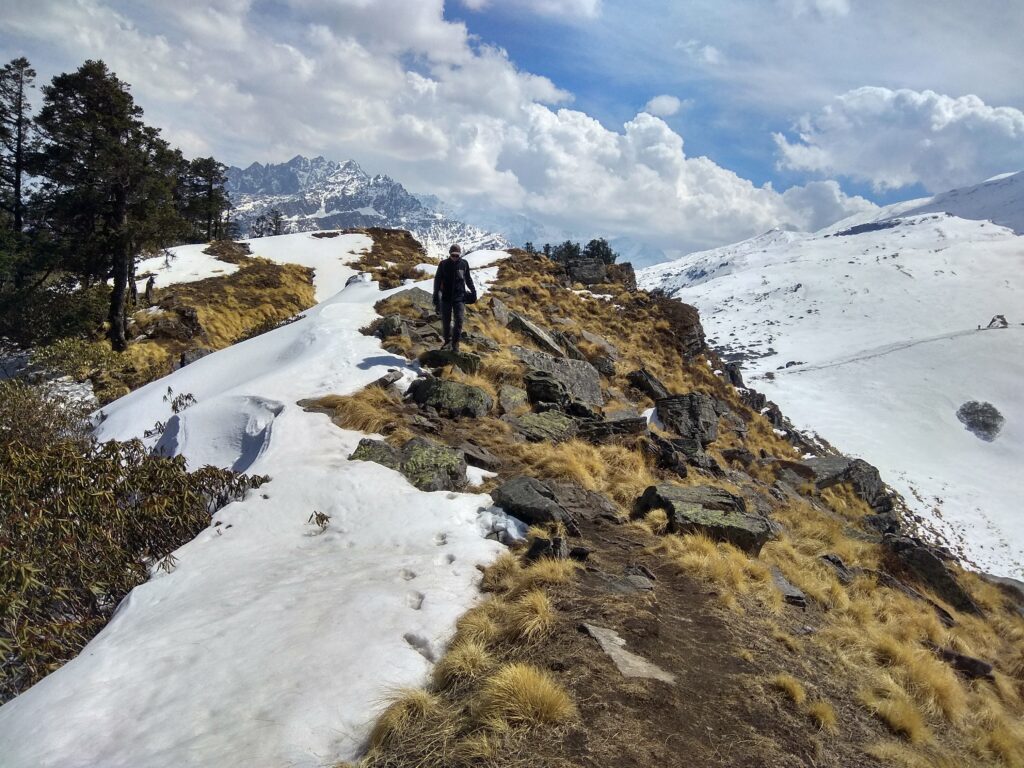
Pangarchulla Trek Altitude:
Pangarchulla trek difficulty:, pangarchulla trek distance:, customize your trek with himalaya shelter:, day 1 drive from dehradun to joshimath.
Drive: 295 km,10 hrs
Altitude: 2,100 ft (640 m) – 6,200 ft (1,890 m)
Accommodation: Guest House / Hotel
Meals: Dinner
Joshimath, a mountain city on the route to destinations like the Valley of Flowers, Hemkund Sahib, and Badrinath, is where the journey starts. The closest city with an airport is Dehradun, which is 295 kilometers away. The day begins early if you have scheduled a drive from Dehradun to Joshimath. By seven in the morning, everyone has gathered at the meeting spot, so you can begin the arduous trip up to Joshimath, a mountain city in the Chamoli region of Uttarakhand. Although today’s only other commitment is the 10-hour trip, it is nevertheless preferable to go as soon as possible for two reasons: Alaknanda has been on our side the entire way. You would have passed past three of the five Panch Prayags, also known as the five sacred river confluences in the Garhwal Himalayas, before arriving at Joshimath by early evening. Because of the rivers’ distinctly identifiable personalities and colours, each of these sights is nothing short of breathtaking. Devprayag: This is where Bhagirathi and the revered Alaknanda River converge. Rudraprayag: This is the location where the powerful Alaknanda joins forces with Mandakini. Here in Karnprayag, the Alaknanda and Pindar rivers merge.
Tonight will be spent in the warmth of a bed at a guest home in Joshimath, a holy mountain city that is located at a height of around 1,890 meters. It would be beneficial for you to relax your body so that it can work properly for the remainder of what is ahead because you have ascended to a significant altitude in only one day. The city has cell phone reception.
One, so you may arrive as soon as you can and allow your body enough time to recover before the following day. Additionally, it is generally a good idea to budget for delays before you start because mountain roads are erratic. Additionally, it is preferable to arrive before dusk. The journey to Joshimath passes through the holy city of Rishikesh and never leaves Ganga’s side. Once you have crossed the city, the route from Dehradun to Rishikesh is flanked by dense, young woods with sunshine peeping through the cracks, turning the green into a vivid shade of dusty gold, and little flecks of life in the air dancing in the warm light. The air is brisk, the road is supple, and the trip is enjoyable. As you go through the jungle, the commotion of the monkeys leaping through the forest, grooming one another on the side tracks, and speeding past the smooth roadways serves as a humorous reminder of whose land you are actually in. After breakfast, you begin to climb a mountain face that is representative of Uttarakhand’s terrain on one side, with layer upon layer of mountains spreading out in every direction, and a valley on the other. If you closed your eyes, you think you were flying since the roads are so smooth.
Day 2 Drive from Joshimath to Dhak and Trek to Guling
Drive: 10 km, 30 mins
Trek: 6 km, 5 hrs
Altitude: 6,200 ft (1,890 m) – 6,857 ft (2,090 m) – 9,373 ft (2,857 m)
Accommodation: Camping (Alpine tents)
Meals: Breakfast + Lunch + Evening Snacks + Dinner
The day is not long today. So there’s no need to wake up early. After a hearty breakfast, you go. Please be aware that today’s breakfast is not covered by the cost, therefore participants will need to make other arrangements for food. Joshimath serves as a hub for several locations in the area, including the Valley of Flowers, Hemkund Sahib, and even the Badrinath Temple. That is to say, it receives a lot of visitors and, as a result, has plenty of amenities. After breakfast, you put our packed rucksacks into a vehicle and drove us to Dhaka, where our trip would begin.
You may leave your extra luggage in the guest house, so keep your packs light and only bring what you need for the walk. Joshimath is around 10 kilometres from Dhaka, and the trip there shouldn’t take more than 30 minutes. The drive is brief yet beautiful. From the beginning, titans surround you. After 20 minutes of driving, you can see Nanda Devi, the second-highest mountain in India after Kanchenjunga, unhindered to your left and Pangarchulla’s crown perched above a dense pine forest to your right.
Reaching Dhak takes roughly 30 minutes. You’ll begin your journey here. The first 30 minutes of the hike are spent ascending on a motorable road, following which you get off the road and go up the mountain on a stone-paved route. The ascent is moderate and steady. Despite being primarily stone-paved, there are still areas of the route that are narrow and unstable, so you must go with utmost caution. Today’s walk is rather straightforward, similar to a stroll in the garden, but in the shade of the shrubs and amid the bleating of the calves. You will acquire close to 800M overall today. Therefore, the stroll across the park now includes a modest elevation, of course!
What you see as strewn colours on the mountainsides are the brightly painted house walls of the numerous mountain towns that perilously perch on these treacherous slopes. You can get a glimpse of the many peculiarities of mountain living on the trail as it travels through the villages of Kharchi and Upper Tugashi. These peculiarities range from the structure of the houses built to support their lifestyle to the numerous sources of income and their close ties to and dependence on nature. A fantastic illustration of the mountain people’s strong relationship with the environment and their uncanny capacity to cohabit with other natural forms in a spirit of support rather than exploitation are the hydro-powered mills that may be seen in the settlements.
Now, other peaks are being added to the mix. While Pangarchulla plays hide and seek at each curve of the route, Dhonagiri maintains a prominent position the entire time. You also start to notice additional well-known peaks; remember to keep asking your local trek guides for their names. The trek’s entire route passes through Nanda Devi National Park. Since it is a protected region, remember to show respect for both the surroundings and the locals.
You reach the next settlement after a section of severe ascent that lasts for two and a half hours. On the route, there are plenty of water sources. The communities also offer wide-ranging vistas of step farming, so you can get a sense of the area’s resilient environment. To get to the next settlement, which is dangerously perched on the precarious ledges of the mountain face, you must traverse these terraced plains. You begin to put some distance between yourself and any indication after crossing Upper Tugashi. You enter the forest, which is home to pine and walnut trees as well as golden and black oaks.
Inquire about the tree whose bark is used to produce butter tea; butter tea is a local delicacy throughout the winter and is another example of utilizing nature to one’s advantage. The last section of the path for today is a gentle ascent. Guling, you are now quite close to the campground. You’ll be there just in time for a hot meal. The greatest views of the Garhwal range may be seen from the vast open field known as Guling Top. It’s an amazing experience to see the sun chase after these peaks twice a day.
The entire environment serves to calm you down. The trees’ hues of red, green, and yellow contrast with the five dozen different shades of brown, the white of the summits, and the sun, which teases the skies by changing their colour every second as evening approaches. After a hearty meal, take a moment to relax before feasting your eyes on the wonders that are being revealed to you as the day draws to a close. You take a little acclimatization stroll in the evening and return to camp before it gets dark because you have climbed quite a bit of altitude today.
Day 3 Trek from Guling to Khulara
Trek: 5 km, 3 hrs
Altitude: 9,373 ft (2,857 m) – 11,122 ft (3,390 m)
A brief day of hiking is planned today among the oak and pine trees that surrounded our campground yesterday. After breakfast, you join the tranquillity of the woodland to end the day as soon as possible. This is crucial since the summit pushes off that evening, and we need to rest our bodies before descending into the darkness and bitter cold. By nine in the morning, you depart the encampment. After spending the previous night in wide spaces, it takes five minutes to enter the dense forest, where you find yourself suddenly in enclosed spaces. However, the lofty forest canopy does present you with a few spots of sunlight.
The numerous flowing streams create motion in the otherwise silent forest, with the drooping pine branches bending in as if for a kiss and the stern oak being the total opposite. In this forest, you will also find Himalayan Birch or Bhojpatra trees, as well as trees used to manufacture butter tea. The enormous fallen trees on the track that you must climb over are the only obstacles in your path. Today’s terrain features a little rise that is not too taxing. From Khulara on, the path may be covered with snow in March and April, and you may even have to set up camp there.
Three hours should be plenty for you to get to Khulara’s campground. It is a vastly open area where the perspective of the peaks widens to include a great number of additional mountains. The sunsets here are incredibly breathtaking; they are like a dialogue between the sun and the sky, with the sun’s smallest movements altering the colour of the mountains and the heavens. You spend some time in the evening distributing the equipment you’ll need for the summit push and giving everyone a quick lesson on how to utilise it to your advantage.
Day 4 Trek from Khulara to Pangarchulla and back to Khulara
Trek: 14 km, 12-14 hrs
Altitude: 11,122 ft (3,390 m) – 15,060 ft (4,590 m) – 11,122 ft (3,390 m)
Before dawn even breaks, the day begins. You get ready and depart our camping at three in the morning. Remember to pack enough water because the day will be quite lengthy and there are no water sources along the way. It will be the longest and hardest day of the journey because it is the summit day. You fill our bottles with water and eat something before you retire for the evening. The hike begins by passing through Khulara’s wide area before climbing gradually through rocky hills. The nights frequently become bitterly chilly. Therefore, be sure to layer up properly.
You will reach the meadows after an hour of inclining over the unsteady terrain. If the sky is clear, glance up to see the beauty of the night. If the ascent up to this point hadn’t already taken your breath away, the silence of the meadows flanked by trees and the stillness of the sky will do it. You reach the top of the ridge line after another hour of ascending gradually. On top, there is a modest stone shrine from which the Pangarchulla and Kuari Pass routes diverge. You turn left from the temple and begin the lengthy, arduous climb up the mountain’s crest to reach our peak. Before you reach the next portion of the route, you must traverse three ridgelines. The ridgeline hike is particularly difficult since it is entirely exposed, making it exceedingly windy and leaving no room for defence against the brisk gusts. This area has a few brief descents, which is a welcome relief from the previous severe ascents. The thin, greyish contours of the summits, obscured by the nighttime fog, give the impression that they are ghost mountains.
By around 6 AM, the sun begins to emerge after we are below the ridge. You won’t want to miss the sky’s shifting hues and the spectacular peaks’ responses to the sun’s motions. You reach the most challenging portion of the summit and push three and a half hours into the climb. Keep in mind that you have a total ascent of around 1,200 metres today and that you hope to reach the peak no later than 11 a.m. You arrive at the hardest part of the climb—the boulder section—by 7:30 AM. Once you figure out how to use these incredibly stable rocks to advance, it becomes much simpler. From the beginning of this segment to the base of the summit, it will take close to an hour and a half. Despite being somewhat level, this demands extra caution since the stones have wide spaces between them that might be severely damaged by even the smallest slip.
The topography varies greatly between the two seasons. This stretch of the climb acquires a heavy layer of snow between March and April, transforming it into a flat, enormous snowfield that is much simpler to negotiate and probably faster to cross. The rocks beneath the snow are revealed in October and December when it melts. The ascent to the top is steeply uphill, starting from the peak’s base. This is also covered with rocks, which makes the ascent difficult in the winter. However, it could move a little more quickly in the spring and summer when snow is more accessible for walking. This final stretch-up will probably take between two and three hours, depending on the climbers’ speed. It is demanding and needs a strong internal drive. By 11 a.m., you should be at the peak. You can see the whole Garhwal Range from where you are standing thanks to the little sections that were previously covered being entirely open. If at all, after this strenuous journey, you feel depleted of vitality, the power of the mountains around you can replenish you.
Prepare to begin your descent after offering a brief prayer at the temple at the peak. You may wish to traverse the most dangerous areas before the sun makes the snow because this will take a very long time as well. It takes a lot of work to descend these sometimes blindingly high mountains, so the trek down may feel interminable. At the three-hour point, you should have finished the boulder portion. Khulara will be reached in three more hours.
Day 5 Trek from Khulara to Dhak and Drive to to Joshimath
Trek: 12 km, 3-4 hrs
Altitude: 11,122 ft (3,390 m) – 6,857 ft (2,090 m) – 6,200 ft (1,890 m)
This day is fairly simple. You only need to follow in our footsteps to return to Joshimath. You finish breakfast by 8 AM and try to depart by 9 AM after taking a nap to get over your morning fatigue. You reach our first campground after an hour and a half of our ascent through the woods. Once you get to Dhak, where you join our car and continue to Joshimath, it will take you a further hour and a half. There is a lot to discover both within and outside of this sacred town. You spend the evenings at the inn.
Day 6 Drive from Joshimath to Dehradun
Altitude: 6,200 ft (1,890 m) – 2,100 ft (640 m)
Meals: Breakfast
The journey is over. Get ready to leave the inn and board your cars to return to Dehradun. Dehradun should be in your sights by late that evening. Please schedule transportation that departs between 11 p.m. and 12 a.m. if you intend to travel that same night so that you may accommodate for any unforeseen traffic delays.
Day 2 How difficult is the trek & what are the challenges?
Pangarchulla trek faq, what peaks are visible from pangarchulla.
Nanda Devi (Main Peak and East Peak): Nanda Devi is the highest mountain in India (except disputed areas) and the 23rd highest peak in the world. It is a twin peaked group, and both the main peak and the eastern peak are visible from Pangarchulla.
Chaukhamba I, II, III and IV: Chaukhamba is a mountain group with four distinct peaks. Among them, Chaukhamba I is the highest, situated at an altitude of about 7,138 metres.
Dronagiri: Dronagiri is a group of peaks in the Garhwal Himalaya. It consists of several prominent peaks, the highest point of which is known as Dronagiri East. This peak is also visible from Pangarchulla.
Hathi Parvat and Ghoda Parvat: These two peaks are part of the Himalayas and are known for their distinctive peaks like Hathi (Hathi) and Ghoda (Ghodi).
Neelkanth: Neelkanth, also known as the “Garhwal Queen”, is a prominent peak in the Garhwal division of the Himalayas. It is situated at an altitude of about 6,596 meters and is named after Lord Shiva (Neelkanth, meaning “blue throat”).
Kamet is the second-highest mountain in the Garhwal Himalayas and is part of the Zaskar Range. It stands at an elevation of approximately 7,756 meters.
Mana Peak: Mana Peak is the highest peak in the Indian state of Uttarakhand. It is located near the Indo-China border and stands at an elevation of around 7,272 meters.
What is the Pangarchulla Trek?
The Pangarchulla Trek is a popular trekking route located in the Chamoli district of Uttarakhand, India. It offers breathtaking views of the Garhwal Himalayas and is known for its diverse terrain, including forests, meadows, and snow-covered slopes.
How long is the Pangarchulla Trek?
The trek typically takes around 6 to 7 days to complete, including acclimatization and rest days.
What is the best time to do the Pangarchulla Trek?
The best time for the Pangarchulla Trek is during the months of April to June and September to November. These periods offer favorable weather conditions and clear views of the surrounding peaks.
Is a permit required for the Pangarchulla Trek?
Yes, a permit is required for trekking in the Garhwal Himalayas. You’ll need to obtain the necessary permits from the Forest Department and follow any additional regulations.
How difficult is the Pangarchulla Trek?
The Pangarchulla Trek is considered to be moderately challenging. It involves both steep ascents and descents, as well as sections with snow and ice. Trekkers should have a reasonable level of fitness and some prior trekking experience.
What is the highest point on the Pangarchulla Trek?
The highest point of the Pangarchulla Trek is the Pangarchulla Peak itself, which stands at an altitude of approximately 4,700 meters (15,419 feet) above sea level.
From the summit of Pangarchulla, trekkers can enjoy panoramic views of several prominent peaks including Nanda Devi, Dronagiri, Hathi Parbat, Ghodi Parbat, Chaukhamba I, II, III, and IV, Neelkanth, Kamet, and Mana Peak.
What kind of accommodation can I expect during the Pangarchulla Trek?
Accommodation along the trekking route usually consists of camping. You’ll need to carry your own sleeping bag, and tents will be set up at designated camping spots.
How do I get to the starting point of the Pangarchulla Trek?
The trek typically starts from the town of Joshimath in Uttarakhand. You can reach Joshimath by road from major cities in Uttarakhand, such as Rishikesh and Dehradun.
Are there any risks or challenges associated with the Pangarchulla Trek?
The main risks include high altitude sickness, sudden changes in weather, and rough terrain. It’s crucial to acclimatize properly, stay hydrated, and be prepared for varying weather conditions.
Is it possible to do the Pangarchulla Trek solo?
While it’s possible to do the trek solo, it’s recommended to go with a group or hire a guide, especially if you’re not experienced in high-altitude trekking or are unfamiliar with the region.
where is the nearest atm in the Pangarchulla trek
The nearest ATM to the Pangarchulla Trek is located in the town of Joshimath, which is typically the starting point for this trek. Joshimath is a small town in the Chamoli district of Uttarakhand,
Is there cellular network available throughout the pangarchulla trek
The last place with reliable network coverage is likely to be the town of Joshimath. Once you start the trek and head into the mountains, the signal strength diminishes significantly.
Why trek with Himalaya Shelter?
“I have been doing treks with Himalaya Shelter for the last two years and they are awesome people with pure humbleness.“
Writes Priyesh.
We at Himalaya Shelter consider our trekkers part of our community, a family of sorts and really understand the efforts that you put into taking that much-needed break and setting off to the mountains. Some of you may wait for months and even a year to plan out that perfect excursion. That’s why we want it to be “a perfect excursion” for you.
Our testimonials (read below) are a testament to our service-oriented mindset.
We take safety into great consideration and ensure our team is trained to handle emergency situations.
For a better experience, we provide accommodation on Twin Sharing throughout the trek. With most trekking operators you would get triple or even quad sharing accommodation.
Our Accommodation will have attached washrooms
Furthermore, we provide the essential safety gear for your trek –
Without any additional charges.
We pamper you with great food which keeps you going on the trek. (On our google maps out of 300 reviews over 80 Trekkers mention great food😋)
We do not outsource services to ensure topmost quality throughout your journey. We use our own fleet of Vehicles to ferry you to the base camp and return.
Is cloakroom available to keep the extra luggage?
Yes! We will provide you cloakroom to keep your extra luggage if you do not want to carry extra luggage while trekking at FREE OF COST
What will the Pick up Point be?
Your Pick-up point will be Prince Chowk, Dehradun which will also mentioned to you in the detailed itinerary!
What are the naerby attraction that i can explore in pangarchulla peak trek
- Joshimath : This is a town located at an elevation of 6,150 feet and serves as the base for many treks in the region, including Pangarchulla. It has various temples and is a significant pilgrimage site.
- Auli : Auli is a renowned ski destination and offers panoramic views of the Himalayan peaks. It’s located not far from Joshimath and is accessible by a cable car.
- Bhavishya Badri Temple : Situated near Joshimath, this temple is dedicated to Lord Vishnu and is one of the Panch Badri temples. It’s believed to be the future abode of Lord Vishnu.
- Nanda Devi National Park : This UNESCO World Heritage site is a must-visit for nature enthusiasts. It’s known for its rich biodiversity and stunning landscapes.
- Tapovan Hot Springs : Located near Joshimath, these natural hot springs are believed to have medicinal properties.
- Chenab Lake : It’s a high-altitude glacial lake near the trail. The lake is surrounded by picturesque meadows and offers a serene environment.
- Tali Lake : This is another beautiful lake on the trek. It’s located at an altitude of around 11,000 feet and offers breathtaking views of the surrounding peaks.
- Gurso Bugyal : A picturesque meadow located near Auli, offering stunning views of Nanda Devi Peak.
- Kuari Pass : While not exactly nearby, it’s a trek that starts from Joshimath and offers spectacular views of the Himalayan peaks.
- Vasudhara Falls : Although a bit further away, Vasudhara Falls is a stunning waterfall located near Badrinath and is accessible with a short trek.
- Tungnath Temple : While it’s a bit of a detour from Pangarchulla, Tungnath is the highest Shiva temple in the world and is an important pilgrimage site.
What is the Qualification of the trek leader?
The minimum requirement to join our team, Trek Leaders should have done the Basic Mountaineer Course
Trek leaders in Himalaya Shelter have extensive experience in trekking and mountaineering. They are familiar with the specific terrain, weather conditions, and challenges of the region where the trek is taking place.
What is the best time to do the trek and how is the weather?
What are the top highlights of the trek.
- Transport support from Dehradun to Dehradun
- Pick-up location: Prince Chowk, near Dehradun Railway Station Pick-up Time: Around 7:30 am
- All vegetarian meals starting from dinner on day 1 to breakfast on the last day
- Professional Guide, Cook and Support staff
- First-Aid kit with Oximeter and Portable Oxygen Cylinder
- Kitchen tents, common tents, toilet tents with portable toilet seats
- Rent for camping equipment like Clean sleeping bags and foam mattresses, Good quality ‘A’ shaped or dome tents, Camping stools, Table and Crampons and gaiters if required
- Forest entry charges for Indian nationals (Additional charges will be applicable for international tourists)
- Porter and mule support to carry camping equipment and personal luggage
- Accommodation throughout the trek on a triple-sharing basis
- Guesthouse accommodation on the first and second last day on a triple-sharing basis
- All applicable taxes
- Your designated hotels may not reopen by the time you reach there. While we are making alternate arrangements, do understand that things may not be as “tip-top” as our designated hotels.
- The gurudwara, Hemkund Sahib may not be open. While we are trying to take permission to go to Hemkund Sahib, if it does not happen, then do understand that the pandemic has put restrictions beyond our control.
- Personal expenses like tips, personal medicines, phone calls etc.
- Any transport support during the trek apart from what is included above
- Any cost or services not mentioned in the Inclusions
- Accommodation in Dehradun
- Adventure Insurance
- Cost arising due to unforeseen incidents like bad weather, medical evacuation, roadblocks etc
- Porter and mule support to carry personal Luggage can be arranged at an additional cost of INR 350 per bag per day (weighing up to 12 kg)
- Please carry a lunch box for packed lunch/breakfast to avoid using polythenes and Aluminium foils. Keeping the Himalayas clean is our own responsibility. Reduce the use of Plastic when you are in the abode of the Sacred Himalaya. 🌱
Upcoming Treks
- 17-07-2021 to 23-07-2021 open
- 17-07-2021 to 23-07-2021 close
Send Request
Your query has been successfully registered. we will contact you within 24 hours., something went wrong.try after sometime..

PANGARCHULLA PEAK TREK
A summit challenge for adventurers
TREK DIFFICULTY
TREK DURATION
HIGHEST ALTITUDE
If you are looking for a power-packed and thrilling summit climb, the Pangarchulla Peak trek offers just that. The summit point of the Pangarchulla Peak trek is situated at a challenging altitude of 15,069 ft.
To begin with, Pangarchulla is a 5-day trek (7 days when you include the travel days from Rishikesh). The trek starts from Auli near Joshimath in the Garhwal region of Uttarakhand. It is situated in the Nanda Devi National Park.
This trek is known for its summit climb. For anyone who has done this trek, that will be the first thing to recall about their trek. The summit day is for one very long. You climb over lots of boulders covered over snow, feeling your feet every step of the way.
While the summit climb in itself leaves you with a strong adrenaline rush, what adds to this experience is the mountain views you get from the top. All along the trek, you are accompanied by grand views of a big part of the Greater Himalayan Range. And at the summit, you are surrounded by them and they all stand so close to you.
And when you trek in March and April, they are filled with blooming Rhododendrons, providing colours to the already beautiful forest. Being in Khullara will transport you to a different world altogether.

Pangarchulla Peak - Complete Trek Information
We have always wanted trekkers to be well-informed before they go on a Himalayan trek . Knowledge is the difference between a safe trek and a dangerous one. It’s also the difference between a wholesome experience and a superficial experience.
Use this section to learn about the Pangarchulla Peak trek. It has in-depth information about each day of the trek, what to expect, and how you need to prepare for it. Many years of expertise have gone into this content. Trekkers find that extremely useful.

Quick Itinerary
Get your trek plan

A route map of the Pangarchulla Peak trek
Drive from Rishikesh to Dhak/Karchi
Drive Distance: 254 km | Drive Duration: 10-11 hours | Pick up point for Indiahikes trekkers: Live Free Hostel, Rishikesh | Pick up Time: 5.15 am
Transport will be arranged at 5.15 AM. It costs Rs 8,000 per Bolero (5-6 seater), and Rs 12,000 per Tempo Traveller (10-12 seater) for the transport, one way. This amount is shared by trekkers. You will reach the base camp, Dhak/Karchi by 5.00 PM.
Drive from Dhak/Karchi to Auli. Trek from Auli to Tali
Trek Distance: 8.1 km | Trek Duration: 8-9 hours | Altitude Gain: 7,785 ft to 11,053 ft
Trek from Tali to Khullara
Trek Distance: 2.65 km | Trek Duration: 3 hours | Altitude Gain and Loss: 11,053 ft to 11,014 ft
Acclimatization Day at Khullara. Trek to Kuari Top and back to Khullara
Trek Distance: 7 km | Trek Duration: 4-5 hours | Altitude Gain and Loss: 11,010 ft to 12,600 ft, and back to 11,010 ft
Trek from Khullara to Pangarchulla Summit, and back to Khullara
Trek Distance: 12 km | Trek Duration: 10-12 hours | Altitude Gain and Loss: 11,010 ft to 15,069 ft, and back to 11,010 ft
Trek from Khullara to Karchi/ Dhak
Trek Distance: 5.25 km | Trek Duration: 3-4 hours | Altitude Loss: 11,010 ft to 7,785 ft
Drive back from Dhak/ Karchi to Rishikesh
Drive Distance: 260 km | Trek Duration: 10-11 hours | Drop off point for Indiahikes trekkers: Live Free Hostel, Rishikesh
The transport cost has to be borne by trekkers. It costs Rs 8,000 per Bolero (5-6 seater), and Rs 12,000 per Tempo Traveller (10-12 seater) for the transport, one way.
Please note: The distance between campsites may vary by 100 meters depending the weather conditions and the route you take. The altitude may also vary by 100 feet for similar reasons.
IMPORTANT POINTS
- It is mandatory for trekkers to carry a copy of their photo ID for entry at forest check posts on the trek.
- At the base camp, your stay will be arranged in lodges.
- On the trek, you will be staying 2 in a tent.
- We have a cloakroom facility at the base camp for excess luggage. Anything beyond one luggage is chargeable at Rs 500 per luggage. Do not leave behind any valuables in the cloakroom.

How Does Each Day Look
Complete day-wise guide with pictures
Day 1 (Pick-up Day): Drive from Rishikesh to Karchi/Dhak

Driving Duration: 10-11 hours drive | Driving Distance: 254 km

Altitude: 7,785 ft

Highlights: The Panch Prayag that you get to see on the journey is the main highlight. Prayag is the place of a confluence of three rivers, and all the five are seen on this route, namely Dev Prayag, Rudra Prayag, Karna Prayag, Nand Prayag and Vishnu Prayag.
The Pangarchulla trek begins from Auli. However, you will be staying at either Dhak or Karchi.
The drive from Rishikesh to Dhak is beautiful. The road chugs along tributaries of the Ganges. It hugs the mountainside and you get views of the vast valleys and forests of Garhwal.
After you cross the village of Pipalkoti, the entire scenery changes. You suddenly see a stark difference in the landscape when approaching closer to the Greater Himalayan Range.
Watch out for the big mountain of Mt. Drongiri from the base camp. This peak will be your company for the entire trek duration.
Karchi has a few interesting things that you need to know. If you are reaching a day in advance or have time post your trek, these are the things to look out for - The Hotsprings, the first sight of Mt. Dronagiri peak welcoming you and the region of Lata, Reini where the Chipko movement started in India.
You will reach by 5.00 PM.
Day 2: Drive from Dhak to Auli. Trek from Auli to Tali
Trek Duration: 8-9 hours | Trek Distance: 8.1 km
Altitude Gain: ⇗ 2,507 ft (8,546 ft to 11,053 ft)
Difficulty: Moderate-Difficult. Continuous ascent which is steep for the first 20 minutes followed by 45 minutes of gradual ascent. Steep again for about an hour, followed by a mix of gradual and steep ascents for 1.5 - 2 hours.
Highlights: Majestic peaks such as Mt Nanda Devi, Mt Hathi, Mt Ghoda, and Mt Dronagiri stand tall around you in Auli.
The day starts with a small drive from our base camp towards Auli.
The trek starts from lower Auli. Upper Auli is 1,000 ft above this. Trekkers do have the option of taking the cable car/ropeway to reach Upper Auli. If you plan to trek, you will reach it after gradually ascending for 1-1.5 hours.
This section will be seeing plenty of waste and is a good opportunity for you to contribute to leaving the mountains better.
From here, the trail enters an oak forest. Within a few minutes, you reach Padiyar temple. You can take a break here if you wish. From Padiyar temple, the trail continues to ascend. In 2.5-3 hours you will reach Padiyar.
At Gorson Bugyal, wide mountain views open up ahead of you. You will trek across the entire length of Gorson Bugyal, which gives you enough time to savour the views. This is a lovely walk one gets to do.
This is also the place you need to look up and catch Himalayan Griffin hovering above you. This majestic beauty is a wondrous bird. After about 40 minutes of moderate ascent, the overhanging trail ends abruptly and you take a U-turn brings you to an overhanging trail which cuts through a cliff.
Continue on this ledge. You can spot Lower and Upper Tugasi villages way below in the valley and also see rhododendron forests from above. The entire valley is below you now. A 20 minutes steep ascent and descent takes you to Tali lake. At Tali lake, you’re above the tree line so you start getting the mountain views again. This with the gorgeous view of Mt. Nandi Devi that makes you go weak in your knees.
From here, your campsite is nestled in between the forest. This should take you around 30-40 minutes to reach.
Day 3: Trek from Tali to Khullara
Trek Duration: 2-3 hours | Trek Distance: 2.65 km
Altitude Difference: ⇘ 40 ft (10,908 ft to 11,010 ft)
Difficulty: Easy. Gradual trek all the way to Khullara.
Highlights: Views of the major peaks of Greater Himalaya.
The trail to Khullara is an easy day. This day will help you get enough rest and spend time exploring Khullara.
You trek through the lovely dense forests of Oak and dwarf rhododendrons. There are plenty of short clearings on this day. When you are about to reach Khullara, you meet the trail which connects from Gulling.
On one side you see Chaukhamba, Neelkanth, Dronagiri, Nilgiri and Hathi Ghoda peaks. Straight ahead of you are Trishul and parts of Nanda Devi. Continue on this trail to reach the upper grasslands.
The Khullara campsite is located in a clearing.
Day 4: Acclimatisation Day at Khullara. Trek to Kuari Top and back to Khullara
Trek Duration: 4-5 hours | Trek Distance: 7km
Altitude Gain and Loss: ⇗ 1,590 ft; ⇘ 1,590 ft (11,010 ft to 12,600 ft and back to 11,010 ft)
Difficulty: Easy. Gradual ascent to Kuari Pass.
Highlights: Camping on an open campsite with views of many mountain peaks. The thrill of climbing to Kuari Pass.
Take the rest day seriously and spend your time in a beautiful setting, watching the sunrise and set.
If you decide to trek up to the Kuari top, it is a moderate climb with a few switchbacks.
Day 5: Trek from Khullara to Pangarchulla Summit, and back to Khullara
Trek Duration: 12-16 hours | Trek Distance: 12km
Altitude Gain and Loss: ⇗ 4,060 ft; ⇘ 4,060 ft (11,010 ft to 15,069 ft and back to 11,010 ft)
Difficulty: Difficult. Initial gradual ascent followed by steep ascent over snow/boulders.
Highlights: Starting the climb in the wee hours and the thrill of reaching the summit when the sun is bright and shiny.
Start early at 4.00 AM, as the summit needs to be reached before 11.00 AM.
From Khullara Campsite , walk towards the forest ridge ahead of you as you connect with the famous Lord Curzon Trail . The initial 30 to 45 minutes of the trek is through a forest ridge along a frozen rivulet. This section will be found buried in a huge accumulation of snow. The ascent of about 100 metres is stiff. Carefully climb up the snow ridge section until you see a vast snowfield in front of you. Observe the snow gully above you in the middle. That is the point where one has to reach. The incline gets steep as you walk on soft powdered snow. You finally leave the forest line behind you. Wear sunglasses to avoid snow blindness.
After walking for 30 to 45 minutes you reach the top of the snow gully. From here you get the view of Pangarchulla Main and Pangarchulla subsidiary summits.
Stay towards the true right of the snow ridge as you walk alongside gaining altitude. The snow accumulation on the ridge from here forth can be huge during the winter season (Mid January till April). After 45 minutes of watchful snow hike along the ridge, you reach the level snow grounds. This can be a possible Advance Base Camp for Pangarchulla Summit. However, there is no source of water here in winter.
From this point observe Chaukhamba massifs in the far north, followed by Mana, Kamet, Abi Gamin, Hathi Parvat, all the way to Nanda Ghunti and Trishul. In the middle sight, the Dronagiri, Changabang and Kalanka peaks are prominent.
The onward approach to the Pangarchulla summit is laborious, but not difficult. It is advisable to have a qualified guide with you for opening the snow route. There are multiple steep sections on soft snow. Proper high ankle trek boots, gaiters and crampons will help in climbing. Crampons are highly advisable to minimize the chances of slipping on snow. The section of the climb can take five-six hours in snow conditions. In post-monsoon season one can reach the summit in 4 hours.
From this point, observe the summit approach the base of Pangarchulla main peak. Six mountain ridges need to be traversed to reach the base of the peak. During the winter season, the whole region is carpeted in snow making it difficult to traverse the area swiftly.
Take the snow trail that descends sixty meters down and then climbs up 120 meters till you reach a level hump. This section is laborious with a sharp descent and ascent. Once you reach the top of the first snow hump, it is time to climb the second one above it.
Traversing the second, third and fourth snow ridges may take an hour and a half. Once you reach the top of the fourth ridge a clear perspective of the summit climb from the base of Pangarchulla Peak can be seen. Move forward towards the fifth ridge which has a gradual ascent as you reach nearer to the base of the peak. As you cross over the fifth ridge, the sixth one appears to be a stone's throw away.
The ascent from here to the summit of the peak is around 300 to 350 meters. The climb to the summit is best approached by following the connecting ridge moving along the right side, to begin with. Halfway through the climb, look for an appropriate point from where the summit route needs to be established.
Ice carving a route via an ice axe will be required from here forth. Take a left as you face the side ridge wall with a sixty-degree incline section. Depending upon the accumulation of snow a fixed rope may be required. As you climb to the top of the razor-sharp cornice, the final summit climb section awaits you. The team should be harnessed on a rope here as the wind here is very strong. Avoid walking on the edge of the cornice at any point as you do the final ridge walk. The summit is less than 100 meters away.
Once at the summit, enjoy the breathtaking 360-degree views of Garhwal peaks. Nanda Ghunti, Trishul ranges are visible from the summit for the first time.
The return is a three-four hour descent down to the camping grounds of Khullara. Take care while descending on snow.
Day 6: Trek from Khullara to Karchi/ Dhak
Trek Duration: 4-5 hours | Trek Distance: 5.25 km
Altitude Loss: ⇘ 3,225 ft (11,010 ft to 7,785 ft)
Difficulty: Easy-Moderate. Moderate to steep descent all the way to Karchi.
Highlights: Walk through walnut trees, golden and brown oak forests all the way till Karchi.
The trail today descends from Khullara but it’s not as steep as the previous day. As you descend, you will go through dwarf rhododendrons. Within 40 minutes of starting from Khullara, you reach the first clearing. You will be surrounded by golden and brown oak forests on all sides.
Continue on the trail leading into the forest. You will reach the second clearing in about an hour. All this time, you will cross small streams along the trail. The water in them is clean and you can drink from them.
Be careful near the streams during the early season. They freeze and become hard and it becomes extremely slippery to walk on them. So, exercise caution when you come across hard ice. The snow that freezes overnight and becomes hard ice is known as Verglas.
Day 7: Drive from Karchi/ Dhak back to Rishikesh
Duration: 10-11 hours | Drive Distance: 260 km
Highlights: The Panch Prayags that you get to see in the correct order on your way down.
Start from Tapoban after breakfast. Enjoy the scenic drive back to Rishikesh. You are expected to reach Rishikesh at around 7.00 PM on this day.

How Difficult is the Pangarchulla Peak Trek?
This will tell you just how fit you must be

Suitable for Experienced Trekkers
At Indiahikes, while rating a trek difficulty we consider a number of factors. These include altitude gained every day, length of trek everyday, highest altitude, nature of the terrain, weather etc. Based on this we rate a trek as easy or difficult or somewhere in between.
Pangarchulla Peak trek is categorized as a difficult trek trek . At Indiahikes, we classify a trek as difficult if it fits the following criteria:
– Challenging, uneven trails – Goes over 15,000 ft – Trekking hours can go up to 9 hours a day – Few exit options – Excellent cardiovascular fitness and prior high altitude trek experience are required
We feel that the Pangarchulla Peak trek addresses all of these criteria. The trek reaches an altitude of 15,070 ft. The summit day goes up to 12 hours of hard trek climbing up and down an altitude of 4,000 ft in a single day. The summit climb is challenging and has steep, uneven and exposed sections.
The last 4 hours of the summit climb are trekking on hard snow over boulders. It is extremely challenging, tiring and filled with tricky sections. It requires that you are sure-footed, always high on alert and carrying a lot of energy.
Apart from the first two days, the rest of the trek is marked with long days with a minimum of 8 hours trek each day.
All of this makes the trek a difficult trek to do. Without prior high altitude trek experience and excellent physical preparation, this trek is almost impossible to do.
Safety on the Pangarchulla Peak Trek
- Safety - Terrain Wise
- Safety - Altitude Wise
- Safety – Weather Wise
- Emergency Exits and Closest Hospital
The Pangarchulla Peak Trek’s challenge comes mainly from its terrain. Until Khullara, the trek follows the route of Kuari Pass and is quite safe. A few tricky sections would be the overhanging stretch from Tali to Gorson Bugyal. But this pales in comparison when we consider the summit day.
The summit climb of this trek is very challenging. It is what makes the trek adventurous. Being mentally, physically and technically prepared to handle these sections will determine the success of your summit climb.
1. Once you reach the top of the snow gully, the entire route to the peak becomes visible. It becomes immediately obvious that the last 4-5 hours of the trek will be on the snow over big boulders. This is the case till you reach the summit.
The challenging part of the trek starts from this section. You will need a technical guide for this part of the trek. Being sure-footed is essential as some places can have loose snow that pulls your foot within the gap between boulders.
2. Once you reach the base of the peak, you will be mainly trekking on the ridge. The ridge section can be seen as 6 small ridge sections put together. Some going up and some coming down. Given that you are trekking on a ridge, both of them can be challenging.
3. As you near the summit, the ridge becomes narrow and windy as well. This section might require a rope. Your technical guide will take a call on this and prepare the trail for you. Towards the end of April, the snow can become hard and icy. This again will require the technical guide to prepare the route for you with an ice axe. Traversing these challenges with proper safety measures will determine the success of your trek and your safety.
At Indiahikes, given these difficult sections, we strongly recommend that you go with a technical guide who knows the trek very well. It is also important that the technical guide has the right equipment like ropes, anchors, and ice-axe to prepare the route for you wherever it is necessary. So, take these preparations seriously.
On this trek, you are climbing around 7,500 ft in the first four days and reaching a maximum altitude of 15,069 ft. Naturally, you have a high chance of getting hit by AMS.
Few aspects of the trek that helps mitigate AMS:
– Except for the first day and the summit climb, every day’s trek and campsites are placed well within a normal altitude gain for each day. With a steady pace, the chances of getting AMS are less.
– You have an acclimatization day on the third day to help you prepare for the long summit climb on the fourth day. This helps your body to prepare itself for the 4,000 ft ascent and descent on the summit day. This also reduces the chances of AMS, HAPE and HACE drastically.
– You also lose all the height you climb on the summit day by the same evening. This again helps your body to recover from any of the altitude sickness symptoms if any.
However, there are still chances of getting hit by AMS.
On this trek, you are prone to get initial symptoms of AMS right from the very first day of the trek given that you climb about 3,000 ft on the first day. To minimize the risk, climb at a steady pace, hydrate regularly and give yourself ample rest once you reach the campsite.
Also, ensure that you do not waste the acclimatization day. Make sure to climb at least a minimum of 2,000 ft on the acclimatization day to reduce your risk of altitude-related sickness on the summit day.
Even after taking all of these precautions, you can still get AMS. Most trekkers usually present with the starting symptoms of AMS — headache or tiredness mixed with perhaps lack of appetite or sleep. The immediate step to take would be to start on a curative course of Diamox, which is 250 mg every 12 hours followed by ample rest. The earlier you treat these symptoms, the higher the chances of recovering and completing the trek.
If you present with symptoms that persist for more than 12 hours, descend to the base camp immediately.
As you climb higher and proceed beyond 11,000 ft, there are chances of HAPE/ HACE to occur as well. In our history of running this trek, we have never had a trekker present with HAPE/HACE. Nevertheless, it is better to be prepared and mindful of the symptoms.
Here’s a Complete Guide to Acute Mountain Sickness, HAPE and HACE:
- What Is Altitude sickness? A Quick Look At AMS, HAPE And HACE
- How To Treat Altitude Sickness – AMS, HAPE, & HACE
- How To Prevent Acute Mountain Sickness (AMS), HAPE and HACE
- 3 Life Saving Drugs You MUST Have To Tackle Altitude Sickness – AMS, HAPE and HACE
The trek gets inaccessible when the snow level goes high or when the snow melts away. It is for that reason the trek is closed for most of the year except April to mid-May. Given that you will be trekking on snow on your summit climb, winter gear is essential. Gaiters and crampons are very much necessary. Hence, having this in your winter kit is essential.
The trek also gets extremely cold on the summit climb as you go up the exposed ridge. This can result in cold-related injuries. But this can be tackled with the right winter gear, the right technique of layering and good insulation techniques .
Emergency Exits: Pangarchulla Peak Trek has multiple trails that reach the Khullara campsite. But at Indiahikes, we have documented and followed the two trails that mark the onward and the descent routes of our trek. Both of these routes mark the exit routes for our trek. Depending on where you are on the trek when evacuation is necessary, you can exit from the nearest exit point.
In general, if you are in the valley where Khullara and Chitrakantha/Tali campsite is located, you can exit from Dhak . While if you have crossed the overhanging section of the trail and on the Gorson Bugyal side, then exit from Auli .
While evacuation from Khullara is easy and simple, evacuation on the summit day is quite challenging. Given the difficulty of the summit climb in terms of the terrain, it is important to have a strong evacuation plan in terms of an emergency.
You will need a proper evacuation kit which contains a stretcher, oxygen cylinder and a high altitude medical kit along with you to tackle any emergency. You will also need good technical guides who can handle the evacuation in case of an emergency.
Closest Hospitals: For mild medical issues, the closest medical assistance can be found in Joshimath . This includes simple fractures, sprain, etc.
Field Hospital Joshimath, Chamoli – 246443 Ph: 8765949852
District Hospital Gopeshwar, Chamoli – 246424
However, for major medical emergencies, the nearest hospital is in Srinagar or Dehradun — which is almost 8-9 hours away from the base camps of this trek.

Why get fit for the Pangarchulla Trek
Fitness matters for the trek
We recommend jogging as the best routine to get fit for a trek. It works on the same muscles that you use while trekking — your calves, glutes and hamstrings. It helps increase your stamina day by day. It is also an easy routine that does not require any equipment or tools.
Fitness target:
To do this trek comfortably, you must be able to cover 10 km in under 60 minutes. This is the minimum fitness required for this trek.

How to achieve this fitness?
- Start jogging at least 4 days a week
- If you cannot run 10 km immediately, start with 2 km and increase to 2 km over 2-3 weeks.
- Once you’re able to run 5 km, increase your pace day by day.
- Gradually increase your pace and bring it down to 10 km in less than 60 mins.
- You must be able to run 10 km in 60 mins consistently for at least 2 weeks before the trek.
This trek requires at least 6-8 weeks of preparation. The longer, the better. So plan your trek soon and start preparing.
Here's a complete guide to get you trek fit.
Strength training tips:
How to get Fitness Approval from the Indiahikes team:
Every trekker needs fitness approval from the Indiahikes team 20 days before the trek date. Without this, you will not be allowed on the trek.
What to upload?
- A minimum of 3 screenshots of your runs/jogs/walks/cycling
- Monthly summary of your routine
Why fitness matters:
Every high-altitude trek comes with a set of challenges. Steep ascents and descents, uneven terrain, snow walks, stream crossings, pass crossings, and summit climb. Even the easiest of treks have some of these challenges if not all of them. Without fitness, trekkers struggle, get injured easily, lag behind, or simply fail to complete the trek.
At Indiahikes, we take pride in the fact that our trekkers are among the fittest in the country. Those who do not meet the fitness requirements are often sent back. Our philosophy is that trekking and fitness go hand in hand. Without fitness, there’s no trekking.
Complete guide to get trek fit

Best Time to do the Pangarchulla Peak Trek
Time your trek well
Pangarchulla Peak trek is accessible for only one month of the year — that is in April . This covers the Spring Season of the year.
The trek is not open during the other months of the year. Before April, the trek has too much snow for the summit climb to be possible.
After April, the snow melts away leaving the route to the summit unsafe with exposed boulders. These boulders are big and have a lot of gaps between them, making traversing them quite challenging for any trekker. It is easily exhausting and very unsafe as well. Because of these reasons, the trek to the summit is best done before the snow melts away.
Pangarchulla Peak in Spring (April)
The month of April offers the right amount of snow for a successful climb to the Pangarchulla summit. Though the rest of the route is open for almost 8 months in a year, the summit climb is best done during this small window.
In April, it is proper Spring on the Pangarchulla trek. At this time, the snow is melting, giving way to lush meadows. The campsites are free of snow but there is plenty of deposited hard snow above 12,000 ft. This is the right amount of snow required for facilitating the summit climb.
Among other attractions is that April is also the season of flowers. You see meadows flowering and Rhodos blooming during this time.
In a nutshell, spring offers the best of both worlds — the perfect window for the summit climb and the time to see fresh blooms. This is the only time the trek is accessible and safe.

How to Reach the Base Camp
Plan your travel

Planning your onward flight/train booking
If you are travelling from Bengaluru, Chennai, Pune, Mumbai or any other city, book your air tickets for Day Zero , which is the day before Day 1 on the itinerary. If your trek start day is 25 August, book your air tickets for 24 August to either Delhi/Dehradun.
There are two options for your flight booking.
Option 1: Fly directly to Dehradun
We recommend this. It gives you an added rest day at Rishikesh. Most metros are directly connected to Dehradun. However, if the cost of the flight ticket to Dehradun is too high, book to Delhi and connect to Rishikesh by bus.
Tip : Dehradun Airport is Jolly Grant is closer to Rishikesh than Dehradun. It is 20 km from Rishikesh and 35 km from Dehradun.
The Dehradun airport is somewhat inconvenient when it comes to city connectivity (either to Rishikesh or Dehradun). Airport buses that ply between Rishikesh to Dehradun via the airport run every hour. In our experience, the hour can stretch to even 1½ hours.
Taxis are available from the airport (plenty). Prepaid taxis are available (look for the pre-paid taxi counter just out of the conveyor belt at the arrivals). You can also flag down a taxi (bargain a bit) with taxis outside the airport. Airport taxis are exorbitant. They usually charge between Rs 800 to Rs 1,000 to Rishikesh.
Usually, most passengers take taxis from the airport. Try to hook up with co-passengers on the flight for your taxi ride to Rishikesh or Dehradun.
Pro Tip : If you want to save real money try to catch an auto just outside the airport terminal complex. They usually come there to drop passengers off. Autos are not allowed to enter the airport complex. They charge approximately Rs 300 to Rishikesh.
If autos are not available, walk for a further 1.5 km to get to the Rishikesh Dehradun highway. From the highway, you can flag down regular town buses or shared autos (shared autos are called Vikram's ). Bus fare is about Rs 30 to Rishikesh. Shared autos charge about Rs 20.
Option 2: Flying to Delhi
Flying to Delhi may be a lot cheaper than getting to Dehradun. Make sure to book a flight that reaches Delhi by 8.00 pm. You must arrive in Delhi on Day Zero and not on Day 1.
Note: If you notice the difference in air ticket prices between Delhi and Dehradun is less than Rs 1000 then book directly to Dehradun. The rest and shorter travel time are worth the difference.
Next, book yourself on a UPSRTC bus to Rishikesh. They are fully AC Volvo buses that leave between 21.00 to 23.00 hrs from ISBT Kashmiri Gate and get to Rishikesh between 3:00 to 5:00 am.
At Rishikesh, wait for Indiahikes pick up at 6.00 am. Contact your driver by 5:30 am. The number of your transport coordinator will be shared with you a week before your departure.
Planning your return flight/train booking
Next, if your onward flight departs from Delhi, then book flight tickets for Day 8 or Day 9. Depending on the day you leave Rishikesh.
Sometimes trekkers worry if they can book an early morning flight out of Delhi on Day 8 Yes, you can. But book flights that depart only after 8 am. Do not book any flight between 6.00 and 8 am. You may not reach Delhi in time.
How to get to Delhi on time for an early morning flight
If your flight is early, say between 8.00 and 9.00 am, then there are two options.
Train : Take the Nanda Devi Express from Haridwar (12402) that leaves Haridwar slightly past midnight (00.17 hrs) to get to Hazrat Nizamuddin Railway Station at 4.50 in the morning. From Hazrat Nizamuddin, you get airport buses from outside the station as well as taxis. For the Metro train walk down to the Hazrat Nizamuddin metro station, take a metro to Durgabai Deshmukh South Campus, get off and connect to the Dhaula Kuan Airport line metro station (there are convenient travelator belts over a skywalk). From Dhaula Kuan you get the metro train to the airport.
Note : Earlier Nanda Devi express would arrive at the New Delhi railway station. From 26 August 2019, it has been extended up to Kota. It no longer goes to the New Delhi railway station. Instead, it goes to Hazrat Nizamuddin railway station . The train number has changed from 12206 to 12402.
Bus : The other option is to take a bus from Rishikesh. It is about a 5½ – 6 hrs journey to Delhi. From Rishikesh add another hour to the journey. So if you take a bus that leaves around 9.00 pm, then expect to reach Delhi at around 3.00 am (ISBT Kashmiri Gate). A bus that leaves at 10 pm will reach Delhi around 4.00 am. AC Volvo buses are the fastest, so opt for them. Non AC buses can take up to 7-8 hrs for the journey.
From Kashmiri Gate ISBT you get Airport buses or taxis.
Note : Metro trains in Delhi do not start before 5.00 am.
If you are taking a flight out of Dehradun
If you are taking a flight out of Dehradun then book yourself on Day 7 . Most metros are now well connected by Dehradun by flight.
Planning your hotel/stay
Hotel options at rishikesh.
Hostel Live Free
Hostel Live Free is situated on the prominent Laxman Jhula Road in Rishikesh. It offers decent accommodation options in dorms and also in private rooms.
Contact number: 099990 20248 Book online: Book online through Booking.com or Trip Advisor Location: https://goo.gl/maps/9H8Xakmt8p2TpYFS6
Zostel is a modern backpackers hostel, excellent for women travelling alone. It has basic amenities such as bunk beds, towels, good bathroom. The entire premises is quite hygienic. Bathrooms are shared. The average cost is Rs 400 – 800 per bed. Rooms start at about Rs 1,200 https://www.zostel.com/ (for online booking). Location: https://goo.gl/maps/ugqLXUBcbgxnFt638
SK International which is next to Zostel is another good option. It has clean rooms with good amenities. Charges are about Rs 1,000 – Rs 1,200 per night. Phone: 013-524-42943. Location: https://goo.gl/maps/3nWu58ynjFyNn6on8
Shiv Shakti Hostel is another good, decent option at a similar price range to Zostel. This is a hostel like Zostel. They also have rooms. Location: https://goo.gl/maps/qLs5wAThyyP8cmfR8
Hotel options at Haridwar
Bedhubs are a good bunk bed stay in Haridwar — which is rare amongst the Dharamshalas and Ashrams of Haridwar. It is quite close to the heart of the action at Haridwar, approximately 500 m from Har Ki Pauri, Ram Ghat. Charges are around Rs 800 -1,000. Phone: 01334 224 567. Location: https://g.page/bedhubs?share
Hotel Radiant near the Haridwar railway station has decent spacious rooms. Room rates are around Rs 750 for a non AC room and Rs 1,050 for an AC room. Contact person – Nitin Sharma – 9557155557. Location: https://goo.gl/maps/1AdiMiTtnAeGfF4Y8
Hotel Rahi , a government-owned GMVN property is fairly decent. Spacious but old building. Almost opposite the Haridwar railway station, just past the bus stop. Prices start at around Rs 700 for a room. Phone: +91-135-2431793 Location: https://goo.gl/maps/bH25Zp8Di9SE3p757
Hotel options at Dehradun
Hotel Drona , which is a government property owned by the GMVN is decent. It is an old, but large and spacious property. It is about 1.5 km from Dehradun railway station. Rooms start at Rs 750. Phone: +91-135-2746847. Book online http://gmvnl.in/newgmvn/online_reservation/ Location: https://goo.gl/maps/sjWSkGhe5LfAN8wDA
MyRoom252 is a new backpacker facility in Dehradun. Modern, colourful and clean. Bunk beds start at Rs 300. Rooms are available too. It is not too far from the Dehradun Railway station. Shared autos (which are called Vikrams) can get you there. For online booking: http://www.myroom252.com/ . Phone: 086308 81083. Location: https://goo.gl/maps/p5xkbMyUF4X5VHwx9
Nomads House is another new backpacker hostel in Dehradun. The atmosphere is good. The place is neat and clean. Indiahikes trek leaders love Nomads House. It is about 10 mins from the Dehradun railway station. Bunk beds start at Rs 400, rooms start at Rs 800. Shared autos are easily available to get to Nomads House. Phone: 9760596464 Location: https://g.page/NomadsHouse?share
What if you miss the Indiahikes pickup? Getting to Karchi on your own
If you miss the Indiahikes pick up from Rishikesh. Here is how you can get to Karchi on your own.
From Rishikesh ISBT, there is a direct bus to Karchi that leaves at 6:30 am and costs you Rs 695.
Alternatively, if you are at Haridwar, there are direct buses from Haridwar to Joshimath. You can book your seats online here: https://www.utconline.uk.gov.in/SeatAvailabilityy.aspx
Tip: Book a window seat on the left for the amazing views.
Joshimath is about 11-12 hours by bus from Rishikesh. On the way, the bus passes Devprayag and Srinagar (the Uttarakhand Srinagar, not the Kashmir one).
At Joshimath, from the main market, shared taxis leave for Karchi every half an hour. These taxis start from Tapoban Taxi Stand, Joshimath. The last taxi is at 4.00 pm. After 4 pm vehicles are scarce and only run if there are enough people. Otherwise, you have to pay for the whole taxi amount.
It takes about 20 minutes to get to Karchi. It is 16 km from Joshimath. So it is almost there.
There is also another bus from Dehradun Railway Station (Mussoorie Bus Stand) to Tapovan(near Joshimath) at 5:30 AM. The bus fare is Rs 695. Get down at Dhak bend, from there Indiahikes Karchi Basecamp is around 5kms.
Tip : While this bus hopping may sound cumbersome, we do it regularly at Indiahikes. They are a fun and a good way to know the real Uttarakhand. You also get to meet very interesting local people. So while no one wants to miss a pickup, don’t be too disheartened if it happens. You may just experience one of your best travel moments!

What to Pack for Your Trek
Things you must take on the trek
- Mandatory Documents
- The Essentials
- Personal Medical Kit
These are documents required for legal purposes by Indiahikes and the forest department. Without any of these, you will not be allowed to trek.
- Original and photocopy of government photo identity card. Anything such as a driver’s license, Aadhar Card, or passport will do. This is required by the forest department for your identification.
- Disclaimer certificate: There are two sections in this. The first part is a personal medical record. The second part is a legal requirement. Download the PDF, read carefully, fill in and sign it. This must be handed over to your Trek Leader during registration at the base camp. – Download disclaimer certificate
- Medical certificate: The medical certificate needs to be filled out by an MBBS doctor, without which the forest department will not issue permissions for your trek. It is also a requirement by Indiahikes – Download medical certificate Note: Indiahikes has a panel of doctors who can help you with a medical certificate. They are available for online consultation. To get in touch with them, please write to [email protected] . They will respond to you within 24 hours. Consultation fee: Rs 300
Keep important documents in a clear plastic cover and slide them into the inner pocket at the back of your backpack. This keeps them from getting wet.

Before you purchase any gear, make sure you visit the Crosstrek Rental store , where you can get custom-made high quality gear at 5% of the buying cost.
You can rent trekking shoes, backpacks, padded jackets, trekking poles, rainwear and headlamps for less than Rs 1400 for the entire duration of your trek. Visit our Crosstrek Rentals store here.
Here is a list of everything you need for your trek.
Shoes and backpack
- Trekking shoes with ankle support ( Available on rent )
- Backpack with rain cover ( Available on rent )
Warm Layers and Clothes
- Warm layers ( Padded jackets available on rent ) - 3 layers if you're trekking in spring, summer and monsoon (1 woollen sweater, 1 fleece, 1 padded jacket) - 4 layers if you're trekking in autumn (1 woollen sweater, 2 fleece, 1 padded jacket) - 5 layers if you're trekking in winter (1 pair of thermals, 1 woollen sweater, 2 fleece, 1 padded jacket)
- 3 Collared T-shirts (Wear one, carry two)
- 2 quick-dry trek pants (Wear one, carry one)
Accessories
- Sunglasses ( Available on rent )
- Sun cap, preferably with flaps ( Available for purchase )
- Waterproof gloves ( Available for purchase )
- Woollen socks (2 pairs of Dry fit + 1 pair of Woollen)
- Headlamp ( Available on rent )
- Trekking pole ( Available on rent )
- Rain jacket + pants / poncho ( Poncho is available on rent )
Toiletries:
- Moisturiser
- Light towel
- Lip balm or vaseline
- Toilet paper ( Wet wipes are strictly not allowed on our treks )
- Reusable plastic covers (for used clothes)
- Steel lunch box, spoon and a coffee mug ( Lunch box is available on rent )
- Two water bottles or Hydration Pack ( Water bottles are available on rent )
Once you run through this list, don't miss this ultimate guide on what gear to take on a trek . It contains tips on what gear to choose, where to get it from and how much to spend on it.
Our only tip: Keep your backpack light. Indiahikes practices low impact sustainable trekking in every aspect of the trek. Carrying your own personal backpack reduces your impact on the mountains by 20% . We expect all our trekkers to carry their own backpacks unless they have a justifiable reason not to.

Carry these medicines with you, easily accessible at all times. Do not take any medicine unless you have consulted your trek leader .
- Diamox (1 Strip): Be on a course of a half tablet of Diamox starting from Delhi every 12 hours (125 mg). Carry on the medication until you descend to Tapoban. Being on a preventive course of Diamox greatly reduces the chances of Acute Mountain Sickness on the Pangarchulla Peak trek.
- Dexamethasone (1 Strip): This is part of the Live Saving Drugs kit. Do not take this on your own. Your trek leader will inform you in case the need arises.
- Nifedipine (5 tablets): Again part of the Live Saving Drugs kit. Do not take this on your own. Your trek leader will inform you in case the need arises.
- Dolo 650 (5 tablets): This is a paracetamol. It helps to tackle fever, mild pain
- Avomine (4 tablets): Carry this especially if you are prone to motion sickness. Pop one-half hour before the start of your road journey.
- Combiflam (5 tablets): Take a combiflam if you get a sudden twist of the leg or a muscle strain. It is a pain reliever. It also contains paracetamol.
- Digene (4 tablets): Take it if you feel the food that you’ve taken is undigested. Alert your trek leader immediately. It could be a sign of AMS.
- ORS (6 packs): Consume a pack of ORS water at least once a day, usually mid-day when you are in the middle of your trek. It replenishes essential salts lost while trekking. Tip : It also makes cold water easier to drink.
- Knee Brace (optional) : Carry this if you are prone to knee injury or have known issues of knee pain.
Our trek leaders carry a high altitude medical kit with them which also consist of Life Saving Drugs . If there is an emergency our trek leaders know how to tackle it. Meanwhile, contact your trek leader before consuming any of these medicines listed here.
Pro Tip: We find that these medicines by trekkers are rarely used. But you cannot do away with them. At the end of the trek please donate unused medicines to your trek leader. Some of these medicines get distributed to villages on the trek and some are added to the Indiahikes medical kit.

Frequently Asked Questions
Get your questions answered here
The total distance covered during the Pangarchulla Peak trek on the Auli-Pangarchulla Peak-Karchhi trail is 37.5 km. The trek starts from Auli near Joshimath in the Garhwal region of Uttarakhand .
The trek spans over 5 days (7 days including the travel from Rishikesh and back). Except for the first two days which are short, you trek for more than 8 hours for the three days of the trek. On the summit day, you trek for about 12 hours long. As such this makes the trek a difficult one for trekkers.
Pangarchulla Peak trek reaches a maximum altitude/height of 15,069 ft.
From Auli, the trek climbs a height/altitude of more or less 7,500 ft during the length of this trek. You steadily climb up to 4,000 ft on the first three days of the trek. On the summit day, you climb about 4,000 ft up and down on the same day. On the last day, you climb down another 4,000 ft again. Please check the detailed itinerary to understand the trek in more detail.
Pangarchulla Peak trek is a difficult trek. At Indiahikes, we classify a trek as difficult if it fits the following criteria. It reaches an altitude of 15,070 ft. The summit day goes up to 12 hours of hard trek climbing up and down an altitude of 4,000 ft in a single day. The summit climb is challenging and has steep, uneven and exposed sections.
All of this makes Pangarchulla a difficult trek to do. Without prior high altitude trek experience and excellent physical preparation, this trek is almost impossible to do.
Amidst the difficulty, Pangarchulla gives trekkers the feeling of adventure and accomplishment of reaching the summit that possibly no other trek gives. You need to be extremely fit to get the privilege to do this trek.
As a measure of your fitness, we need you to:
Run at least 5 km in 30 minutes & 10 km in 62 minutes before your trek. Consistency of your workout also matters, so aim to jog 30 km a week or 150 km in a month. It's a minimum mandatory requirement if you wish to trek with us.
How to Get Fit for Your Trek
After you register, you will be sent a questionnaire about your trekking experience and medical history. Additionally, you must attach a screenshot of a 5 km run under 35 mins only to get approved for the trek.
High-altitude trekking experience of above 14,000 ft or at least moderate-difficult trek experience is a preferred requirement.
Once you get confirmed for your trek, we will diligently follow up on your fitness routine. Our team will also assist in putting you through a fitness plan. It will ultimately help you have a safe trek experience.
Joshimath is the last town where you’ll find ATMs to make some cash withdrawals. All major private and public sector banks have their ATMs and some even have branches in Joshimath. However, cash runs quickly at the Joshimath ATMs. Hence, Rishikesh is your best bet to make last-minute cash withdrawals.
We advise you to carry around Rs 4-5k in cash to pay for your transport to the basecamp, for rental gear deposit and personal expenses en route to the basecamp. If you are planning to extend your visit around Joshimath after the trek, we advise you to carry more.
If you’re an Indiahikes trekker, there is no major need for cash once you arrive at the base camp . All meals, accommodations, permits, and related expenses are taken care of by Indiahikes.
Yes, you can keep the extra luggage at the base camp. Once the trek ends, you will be able to collect the luggage. Our team will arrange for this.
Ensure you do not keep any valuables at the base. Laptops, mobile phones, cash or any important items cannot be kept here.
Given its difficulty, the Pangarchulla Peak trek can be done only in April. It also has an extensive selection process. It is advised to book this trek 3-4 months in advance.
On any difficult trek like the Pangarchulla Trek, we usually take a maximum of 15 trekkers.
Having more footprints through porters or mules on any trail isn’t good for the ecosystem. Keeping this and the spirit of trekking in mind, there will be no offloading available on this trek. Check out ways to make carrying your backup easier
However, if you have any medical issues and are not able to carry your own backpack, you can offload your backpack. The cost of offloading on the Pangarchulla Peak trek is Rs 2,100 for the whole trek. Find details about the offloading process here.
Photo Gallery

Expert Speak
Sandhya UC, Co-Founder, COO

Sandhya is a founding partner at Indiahikes. Over the past ten years, she has explored and put on the map a few of the greatest Himalayan treks in India, including Kashmir Great Lakes and Kedarkantha. She is a TedX Speaker and has been awarded the " Women of Worth" Award by Outlook Business in 2017. She believes in sustainable living just as she believes in sustainable trekking.
Here’s Sandhya talking about one of the well-known treks in our country.
What I Like About Pangarchulla Peak Trek
Sandhya is a founding partner at Indiahikes. Over the past ten years, she has explored and put on the map a few of the greatest Himalayan treks in India, including Kashmir Great Lakes and Kedarkantha. She is a TedX Speaker and has been awarded the "Women of Worth" Award by Outlook Business in 2017. She believes in sustainable living just as she believes in sustainable trekking. Here’s Sandhya talking about one of the well-known treks in our country.
1 . An adventure-filled summit climb
This trek is known for its summit climb. For anyone who has done this trek, that will be the first thing to recall about their trek. The summit day is for one, very long. You climb over lots of boulders covered over snow, feeling your feet every step of the way.
As you climb high, you also traverse lots of tricky, steep and exposed sections which adds to the thrill and adventure. You also climb till 15,069 ft, almost 4,000 ft up and down on the summit day. All of this makes this trek a very exciting and adventure-filled one.

An adventure filled summit climb on the Pangarchulla trek. Picture by Satyen Dasgupta
2 . Grand views of the Greater Himalayan Range
This feeling is unparalleled and very hard to find in any other treks in the Himalayas. You are surrounded by a 360-degree view of Hathi Parbat, Mana Mandir, Kamet, Nanda Devi, Dronagiri, Chaukhamba, Ghori Parbat and many more peaks that are steeped in mythology and mountaineering stories.

The mountain views are so grand on this trek that it makes all your efforts to reach the peak worthwhile. Picture by Satyen Dasgupta
3 . Camping at Khullara
Very few campsites in the Himalayas can compare to Khullara. Khullara is a big open ground surrounded by dense beautiful forests and grand mountain views. The forests for one are a highlight themselves, providing the setting of a forest in a fairy tale.
And when you trek in March and April, they are filled with blooming Rhododendrons, providing colours to the already beautiful forest. Being in Khullara will transport you to a different world altogether. And what's more, you get to spend two days at this campsite (including the acclimatization day).
Even if you leave these aspects out, the Pangarchulla Peak is a superb trek. The beautiful sights and challenges of the trek make it a trek worth doing.

The picturesque Khullara campsite is known for stunning sunrises and sunsets. Picture by Dan
Why fitness matters on the Pangarchulla Trek
Pangarchulla is not an easy trek by any means. The summit push involves a continuous climb from wee hours such as 1 am to almost 10 or 11 am. That's 10 continuous hours of trekking at high altitudes, over snow and hard boulders. Not to mention, you're climbing to 14,000 ft., which is a very high altitude.
It requires fit legs and strong lungs to do this trek, which means you have to work on your fitness for at least two months before you step on the trail.
Watch this video to know about how difficult the trek is and why fitness matters.
Trek Trivia
Things Nobody Tells You About Pangarchulla Peak
- The Story Behind the Name
- The Divine Flower of the Himalayas
- A Picture-Perfect Lake
- Camp Under an Ancient Walnut Tree
Have you ever thought why Pangarchulla is called Pangarchulla?
Pangarchulla has an interesting story behind its name. If you look at Pangarchulla Peak from the base when it is not covered in snow, it looks like a big black chimney. At its base, many maple trees grow.
So Pangarchulla is a literal translation describing its appearance where it looks as if a chimney is placed amidst maple trees. Pangar means Maple, which refers to Maple trees and Chulla means a chimney.

Did you know Pangarchulla is famous for Saussurea Obvallata?
Saussurea Obvallata or Brahma Kamal is a flower that blooms in the alpine meadows of the Himalayas above 14,000 ft. Just 1,000 ft below Pangarchulla Peak, on the other side, you will find vast meadows filled with Brahma Kamal flowers.
Many local people trek ‘barefoot’ to the top of Pangarchulla, descend to the meadows, collect these flowers and offer them to their local deity. It is a common ritual in many parts of the Himalayan region, where you see people wearing these flowers on their caps once they are offered to their deities because they believe it brings good luck.

Why you should not miss visiting Tali lake?
Tali lake is placed right at the end of the treeline where high altitude meadows start. The reflection of Mt Nanda Devi, Mt Dronagiri and the other mountains in the lake is stunning.
In winters, the same lake turns into a frozen ground on which you can play ice hockey and skate all around!

The specialty of Akhrotghetta campsite
Akhrotghetta campsite is located under a huge lone walnut tree that is hundreds of years old. That’s where it gets its name from. Akhrot means walnut. From here you get an amazing panorama of the mountains like Hathi Parvat, Gauri Parvat, Mt Barmal, Mt Dunagiri, Garud Parvat etc.

Leaving the Mountains Better
Green Trails is our promise to leave the mountains better. We have removed over 1 lakh kilos of the waste left behind by others on trekking trails. Yet this is a small percentage of what we do. Green Trails dives into reducing the use of resources, reducing our carbon footprint and bringing about a change in the daily practices of our trekkers too.

Other Treks Like Pangarchulla Peak

Moderate-Difficult
Goechala Trek
Get Trek Info

Warwan Valley Trek

Bali Pass Trek

Kedartal Trek
The closest you can get to Mt Kanchenjunga without climbing it
The high adventure from Ladakh to Jammu & Kashmir
A Grand Pass Crossing High on Adventure
Treks by Categories
Treks by season, treks by month, treks by duration, treks by difficulty.
- Easy - Moderate
- Moderate - Difficult
Treks by Region
- Uttarakhand
- Himachal Pradesh
- Lahaul and Spiti
- Jammu & Kashmir
- West Bengal
- Chhattisgarh
- Madhya Pradesh
Treks by Experience
- Family Treks
- Stargazing Treks
- Senior Treks
- Adventure Therapy
- Summer Camps
- Youth Camps
Quick Links
- Upcoming Treks
- Cancellation policy
- Work with us
- Our sustainability practices
Follow Us On
- Privacy Policy
- Terms & Conditions
080 468 01269
Mon to Sat - 9.30 AM to 7.30 PM
Sun - 9.30 AM to 6.30 PM
Bengaluru Office
139, Defence Colony Road, Defence Layout, Sahakar Nagar, Bengaluru, Karnataka - 560092
Dehradun Office
Mohabbewala, Titan Road, Near Titan Factory, Chandramani Khalsa Dehradun - 248002
© 2024 Indiahikes Private Limited
All images are copyrighted by their respective authors.

A Challenging Summit In Uttarakhand
Highest Altitude
Joshimath, Uttarakhand
Mar & April
Pangarchulla Peak Trek
The Pangarchulla Peak Trek is breathtaking, and at the same time, it has an excellent challenge to reach its summit. It offers awe-inspiring views of the Garhwal Himalayas. Standing tall at 15,069 feet, reaching the summit is a great challenge that rewards hikers with breathtaking panoramas. The Pangarchulla trek is moderate in grade and requires a good fitness level. Trekkers can marvel at the famous Garhwal Himalayan peaks on clear days, including Nanda Devi, Kamet, Hathi Ghoda Parbat, Chaukhamba, and Mana.
The trail of the Pangarchulla Peak Trek winds through dense forests, a serene world adorned with beautiful flowers and a glistening carpet of snow. It’s not just an adventure but a journey through a captivating world of tranquillity and natural beauty. The trek features stunning rhododendrons and pristine snow carpets, a sight that will leave you spellbound and yearning for more.
The best times to embark on this trek are March, April, September, and October when the weather is mild, and the slopes are stable. It’s important to note that during other times, the slopes can become unstable and dangerous, with exposed boulders posing a risk. This thrilling expedition is perfect for those seeking to test their endurance and determination while immersing themselves in the Himalayas’ stunning landscapes and panoramic views. However, safety should always be a priority, ensuring a secure and confident trekking experience.
- Stay will be on a twin-sharing basis in tents
- + 250 Trek Insurance (Optional)
- Discount Policy
- Transport Optional ( INR - 1,600 extra )
Pickup from Arctic Hills By Opulence Hotels – Rishikesh at 6.30 A.M & will drop at same location by 7 P.M
- Inclusions & Exclusions
- Food Provided Trekup India
- Safety With Trekup India
Call Our Mountain Experts
Fix Diparture Dates
Pangarchulla peak trek videos.
Videos by experts watch these videos to prepare well for a Successful Tre

Want To Trek Like Pro?
Check out the following videos if you want to trek like a pro trekker and improve your skills. These videos contain helpful tips, tricks, and techniques to help you trek like a pro. Whether you’re a beginner or an experienced trekker, these videos can provide valuable insights to enhance your trekking experience. So, watch the videos below by Trekup India experts to take your trekking skills to the next level.
Know Everything About Acute Mountain Sickness
Acute Mountain Sickness is a medical condition that can occur when individuals travel to high altitudes, typically above 8,000 feet. It is caused by the decrease in air pressure and oxygen levels in the air as altitude increases. Symptoms of Acute Mountain Sickness may include headache, nausea, vomiting, dizziness, and difficulty sleeping. To avoid Acute Mountain Sickness, it is important to gradually adjust to high altitudes and seek medical attention if symptoms worsen. To learn more about this condition, check out the videos by Trekup India.
Day Wise Detailed Itinerary of Pangarchulla Peak Trek
Day 01: rishikesh – garudganga by surface 225 kms approx 8 hrs.
- Driving Distance: 225 Kms:
- Time Take : Approx 7 Hrs
- Overnight stay at Guest House / Hotel
- Meal Dinner Only
Today’s morning pickup will be from Rishikesh at 6:30 am. The entire day will be a driving day, and meals en route will be self-purchased. A good mobile network and connectivity will be available. Overnight stay will be in a guest house or hotel provided by Trekup India.
Please report at Natraj Chowk in Rishikesh at 6:30 am, where a Trekup India representative/driver will meet you in the morning. Once everyone has boarded the vehicle, we will proceed with our day-long drive of approximately 7-8 hours to Garudganga/Joshimath. We will enjoy the incredible mountain drive, following the river Ganges until Devpryag, where it changes its name to Alaknanda. Along the way, we will pass through some significant Himalayan towns, such as:
– Devpryag: Witness the incredible confluence of the Alaknanda and Bhagirathi rivers.
– Rudrapryag: The beautiful Alaknanda River merges with the Mandakini River.
– Karanpryag: The place where the Pindar River merges with Alaknanda.
This drive is fantastic, as you will notice that five rivers merge into the River Alaknanda to eventually form the holy River Ganga, also called Panch Prayag. The five prayags are Vishnupryag, Nandpryag, Karanpryag, Rudrapryag, and Devpryag. It is believed that anyone taking a dip in these five Prayags cleanses and purifies the soul, bringing them closer to Moksha.
After a long, hectic drive, we will reach our destination, check into the accommodation, and have some time for rest. Here, we will meet with Trekup India team members, and your trek leaders will be introduced during the evening briefing.
Day 02: Garudganga -Joshimath-Tugasi Village by surface 35 KMS approx 1.5 Hrs and trek to Guiling top (9600 Ft.) for approx 3 Kms
- Driving Distance: 35 Kms:
- Time Take during drive : Approx 1.5 Hrs
- Trek Distance: 3 Kms :
- Time taken trekking: Approx 3-4 Hrs
- Overnight stay at Camps in tents on twing sharing
- Meal Breakfast / Lunch / Snacks / Dinner
After breakfast, we will drive for 1.5 hours to the trek point and then start our trek to Guiling Top, gaining an altitude of 3450 feet. Water sources will be available, and there will be mild network coverage until Tugasi Village. We will have an overnight stay at Trekup India camps.
We will enjoy breakfast at our booked accommodation in the morning and then drive to Tugasi village. Upon arrival, we will get out of our vehicles and begin our trek to Guiling. The trek will mostly pass through beautiful Himalayan villages and consist of steep and gradual ascents to the Guiling top. Remember, don’t fill your water supplies while trekking through the villages to stay hydrated. You will also have the chance to meet and interact with local people, farmers, and shepherds and learn about their daily mountain life and hardships. You might hear some local mountain stories. We will likely reach our campsite to enjoy a hot lunch at Trekup India’s campsite. After checking into our camps, we can stroll around the campsite to capture views of the great Himalayan peaks, including Doronagiri, Hathi Parvat, Guari Parvat, and others. Later, we will enjoy tea, snacks, and dinner at the campsite and prepare for the next trek.
Day 03: Guiling – Khulara (11800 Ft.) by Trek 4 Kms approx 5-6 Hrs
- Trek Distance: 4 Kms
- Time taken: Approx 5-6 Hrs
- Overnight stay at Camps in tents on twin sharing basis
Today, enjoy a gradual, steep trek to Khulara, gaining approximately 2200 Feet. Do carry 2 litres of water, as this day you might not get a water source. Do not expect connectivity; leave yourself in nature. Spend a beautiful night in Trekup India.
Wake up to a beautiful mountain morning with a cup of black tea, gazing at mighty sun rays over the vast mountains. After a warm breakfast, we prepare for a stricter day trek to our next destination. The trek passes through the beautiful oak, Rhododendron and wall nut forests. Trekking through the forest means a greater chance to spot different species of birds; it can be a paradise for birdwatchers; hence, binoculars will benefit enthusiasts. On the other hand, keep a close watch on spot wild animals. We will get natural water sources to fill our bottles and keep our bodies hydrated. The Khulara campsite offers even better & more mountain views than the first campsite; some of the peaks visible are Doronagiri, Kamet, Kedarnath Peak, Kedar Dome, Chaukhambha, Mana I, Nanda Devi, Nanda Ghunt and others. We make it to the campsite for lunchtime, enjoy a hot lunch, and spend some time regaining and conserving our energy for the upcoming challenging destination. You may ask your trek leader to demo how to pitch the tent and learn some mountain survival skills.
Day 04 Khulara – Kuari Pass – Khulara (12500 Ft.) by Trek 7.5 Kms approx 6-7 Hrs (both Way)
- Trek Distance: 7.5 Kms
- Time Taken: Approx 6-7 Hours (both way) Day for making it to Kuari Pass summit by gaining an altitude of 700 Ft. through Lord Curzon Trail .
- Overnight stay in tents (twin sharing)
- Meal Breakfast / Lunch / Snacks / Dinner
This morning, wake up to the freshness of the mountains and see the golden rays of the sun on these pretty mountains; if you feel like doing this, leave yourself in the lap of nature and meditate for 10-15 minutes. Enjoy cooked breakfast at the campsite, and after that, along with us, our expert Trek leaders, we proceed our trek to Kuari Pass; the trail passes through the Oak and Rhododendron Forest; enjoy the chirping of birds, best for Birdwatcher (Do not forget to carry your binocular), after walking through the forest the landscape changes to beautiful mountains views. After an hour, we will follow the Lord Curzon train towards Kuari Pass; after walking for 30-40 Minutes, we will come to a view spot, where we have an opportunity to witness incredible views on clear days of Chaukhambha, Neelkanth Peak and other peaks. Will we start Steff ascending to Kuari Pass peak at 12500 Ft. Do not forget to energize yourself with Nutri / energy bars (you must carry some), as well make sure your water bottles are filled to keep you hydrated and unique care against harsh sun is required, hence be prepared with a Sun hat and sunscreens. After spending quality time at Kuari Pass’s summit, we descend the same route to our Khulara campsite. Evening in leisure time for rest, relaxation, and getting ready for another stricter day.
Day 05: Khulara – Pangarchulla – Khulara by Trek 14 Kms approx 11- 12 Hours (both way)
- Trek Distance: 14 Kms
- Time Taken : Approx 11- 12 Hours (both way)
- Overnight stay at Camps in tenyts on twin sharing
- Finally, the final summit has come, we will start early in the morning, the day might be tiring as it will be steep climb on snow / boulders and straight gaining 3269 Ft. Carry enough water for the day.
Today morning we start early in the morning today (Between 3-4 am); get yourself prepared for the day, as all efforts and hard work are going to be utilized here; we are sure that by today, your body will be fully prepared for some steep and rigid step, though you will be exhausted, in the end, you will feel it worth and one of the best moment for your life, that you will cheer for a lifetime. Though the scenery experience will be unique as the views and landscape change from ethereal forestation to vast open meadows, the pretty blue skies and the empty land can be seen till your vision reaches. Finally, after a 6 hours body tiring climb to Pangarchulla summit at 14700 Ft. and, a vast, magnificent 360 degrees of Garhwal mountains greet you with its beauty; you will just be mesmerized by the never-before-seen beauty; it blows your mind & soul to just another level. Our advice is to sit for 5-10 minutes, close your eyes, meditate & feel nature, the sound, the freshness, and talk to your soul like you are in a different world. Have an opportunity to witness some of Garhwal’s high peaks, such as Kedarnath, Kharchakund, Chaukhamba, Parvati Parbat to the West, Avalanch Peak to the North, Kamet, Mana and many more. The river gorge of Rishi Ganga, Alaknanda, Dhauli bounds Pangarchulla. Later, after completing the summit with excitement, we returned to the Khulara campsite and enjoyed hot tea and snacks, followed by dinner.
Day 06: Khulara –Tugasi by trek 11 Kms approx 7-8 Hrs – Joshimath by surface 35 Kms approx 1.5 Kms
- Trek Distance: 11 Kms:
- Time Taken: Approx 6-7 Hrs
- Overnight stay at Camps
- Following back same route we trek on steep descend to Tugasi and there after drive to Garudganga for overnight stay at Trekup India accommodation, followed by certificate ceremony.
After a leisurely breakfast at Trekup India campsite this morning, we will return to our hotel in Joshimath. From Khulara, we trek until the Tugasi road head, following the same route we have trekked up. On this day, you will have the final chance to witness the fantastic nature and mountains you will miss in your cities. On arrival at your accommodation, it is time to freshen up. Later, we will have a certificate ceremony.
Day 07: Garudganga – Rishikesh by surface 225 Kms approx 7 Hrs
- After having tea or coffee, we will depart to Haridwar from Joshimath.
- You will be reaching Haridwar in the evening around 6 to 7 PM.
- Get your bookings and tickets done accordingly.
- You can also do the tickets for your hometown after 8:00 PM
- No Accommodation
- Meal Breakfast Only
Today morning, after breakfast we board our vehicles and proceed our drive to Rishikesh, reaching in the evening hours between 1800-1900 Hrs. So, make your onwards plans accordingly.
Pangarchulla Peak Trek Route Map
We’ve prepared a comprehensive Trek Route Map for your upcoming adventure to Pangarchulla Peak Trek , which outlines the entire journey including all stops and trails. This map provides detailed information on the terrain, distance between points of interest, and estimated travel time to help ensure a safe and enjoyable trek. We’ve carefully curated the map to ensure that you have all the necessary information at your fingertips. Please take a moment to review it thoroughly, and don’t hesitate to reach out if you have any questions or concerns.
Kashmir Great Lakes Trek Altitude Chart
The Trek Altitude Chart is a useful tool for Trekkers to monitor their altitude changes during their rides, allowing them to plan their routes more efficiently and track their progress over time. This Pangarchulla Peak Trek chart is beneficial for both casual and experienced Trekkers, helping them make the most out of their Trek experience.
Trek Cost Inclusions
- Stay: 4 Nights of tented accommodation at individual campsites of Trekup India on twin sharing and 2 nights of hotel, guest house on sharing basis.
- Meals: Trekup India will provide freshly cooked meals during the trek starting with Dinner on Day 1 to tea, coffee on day 7 (Meals are simple, nutritious, and vegetarian)
- Transport (Optional): Rishikesh to Joshimath and return. ( 1600 extra )
- Trek Insurance (Optional): Trekup India recommends that all trekkers consider getting trek insurance. This is optional, but highly recommended. Trek insurance covers unexpected events that may occur during your trek. The cost of the insurance starts from INR 210. Please read more about what is included in the coverage and why it is mandatory on treks.
- Trek Equipment: Sleeping bag, Sleeping tents, Kitchen tent, Dining tent, Toilet Tent.
- Amenities: All utensils, sleeping mattresses (Black foam mats), Crampons, and Gaiters for snow.
- Health & Safety: First Aid Box, Oxygen Cylinders, Stretchers, Oxi meters, BP Machines, health.
- Permits: Forest Permits and Camping Permission Fee
- Trek Crew: High Altitude Chef, Helpers, Trek Leader & Guides, and other support teams.
- Potters & Mules: Potters and Mules are to carry all trekking equipment, ration, and vegetables.
Trek Cost Exclusions
- GST 5% (it is Mandatory)
- Any Meals/accommodation beside the itinerary or not mentioned in the program.
- Any Bus / Airfare to/from trek start/end point
- Personal Medical expenses do carry your medication.
- Any personal services such as Laundry, phone calls, liquors, mineral water, etc.
- Any still / video camera fee
- Any Entrance fee Monuments, Monasteries, Museums, Temples – Pay directly on the spot.
- Mules or porter charges to carry private baggage (Offload Charges for bag 365 per day, per bag if paid online (at base camp 2,550). Note: Bag weight should not be more than 10 kg.
- Any emergency evacuation charges
- Any services that are not mentioned in the cost inclusion section.
What should you pack for the Pangarchulla Peak Trek
Pangarchulla Peak Trek is a high-altitude trek. The trekking gear you have to have for this particular trek differs from normal treks. Thus, read this whole segment. There is an important question that the trekker who is doing trek asks, like what all things to carry while trekking. Below, we have provided the details on everything you should take; an easy way to remember is by Head to foot or foot to head. We have prepared from Head to foot.

When trekking it's important to carry headgear to protect your head and face.
Heading out for a trek? Don’t forget to carry headgear to protect your beautiful face and head from the sun, wind, and dust! It’s an essential accessory that keeps you safe and comfortable throughout your adventurous journey. So, make sure you pack it before you step out into nature!
- Head Lamps – When trekking at night, headlamps are essential to illuminate your path while keeping your hands free. Headlamps come in different sizes and lumens, so it is essential to choose one that suits your needs.
- Hats or Cap – Caps or hats are also necessary when trekking in different weather conditions. Caps protect your head from the wind and freezing temperatures at night, while hats provide shade and protection from the sun during the day. It’s essential to ensure that your hat has a strap to prevent it from being blown away by the wind.
- Sunglasses – Sunglasses are also essential for trekking. Your sunglasses should protect your eyes from harmful UV rays and fit your face perfectly to avoid falling off while climbing, jumping, or crossing obstacles. The glass of your sunglasses should also be designed for different weather conditions to provide optimal visibility.
- Buff / Balaclava – Lastly, a buff or balaclava is a must-have to protect your mouth or neck from extreme temperatures and keep them warm. Buffs and balaclavas come in different materials, thicknesses, and designs, so it’s important to choose one that suits your needs and preferences. Depending on the weather conditions and your activities, you can wear them as neck warmers, face masks, or headbands.
When trekking in high altitudes, prepare for cold weather by wearing layers. Layering traps heat, keeps you warm, and allows you to easily adjust your clothing as temperatures fluctuate.
Layering is important for different seasons when trekking. When planning a high-altitude trek, it is important to prepare for the cold weather. Wearing layers is the best approach as it provides both protection and flexibility when the weather changes frequently in the mountains. Layering helps to trap heat and keep your body warm, while at the same time allowing you to easily adjust your clothing as the temperature fluctuates. By wearing layers, you can enjoy your trek comfortably and stay safe in the unpredictable mountain weather
- For spring, summer, and monsoon treks , consider wearing three layers: a woollen sweater, a fleece, and a padded jacket.
- For autumn treks , add one more fleece layer to make it four layers.
- For winter treks , you may need five layers with thermals, a woollen sweater, two fleeces, and a padded jacket.
- T-shirt/sleeve shirt – Bring three T-shirts and two quick-dry trek pants, wearing one and carrying the others. Long sleeve shirts help to protect from sun UV rays. We recommend synthetic T-shirts as they get dry quickly when they get wet.
- Hiking / Trekking Jacket – down jackets (-5 to-10 C) or two-three-layer jackets.
- Thermals – at least two pairs of thermals help keep the body warm during cold weather.
- Undergarments – you can carry them according to your habitual and hygiene requirements.
- Gloves – 1 pair of gloves will keep your hand warm and nice.
- Trek Pants – Bring 2 to 3 comfortable trekking pants. Trekking pants play a significant role, as they are designed for comfort and mobility, making trekking easier. It should be Synthetic so that it gets dry quickly when wet.
- Rain Wear – you can carry a raincoat or Poncho. During long rains and snowfalls, the waterproof jackets start leaking. Still, the Poncho and raincoats keep you dry, so choose accordingly.
Tip: If you choose a raincoat on your trek, carry a small waterproof cover so things inside your backpack can’t get wet. If you carry a Poncho, you don’t need to worry. It protects both you and your backpack.
When it comes to planning a trek, one of the most important aspects is to ensure that you have the right kind of foot gear.
- Trekking shoes which are waterproof and have ankle support. Walking / Hiking sandals which can be used off the trek, i.e., in the morning and evening hours when you reach the campsite, basically to get your feet rest from heavy boots, sometimes used for crossing streams and rivers, it’s more comfortable and safer than crossing barefoot or wetting your shoes. Sneakers (Optional) can be worn for normal driving days or used around the camp.
- Socks – you should at least carry 3 to 4 pairs.
- Microspikes & Gaitors will be provided by Trekup India when required. You don’t have to carry them.
Personal First Aid Kit
Don't forget to pack your personal first aid kit! It's always better to be safe. So, make sure you're prepared for any unforeseen circumstances.
Below are some common medicines generally required/used during your adventure trip; however, please consult your doctors prior.
- Antiseptic towel or water syringe (to clean the wound)
- Butterfly bandage for a small cut
- Cotton and elastic bandages and sterile gauze pad for larger wounds
- Latex gloves are used when the wound bleeds.
- Medicine for Diarrhea (Upset stomach)
- Medicine for cold, flue/fever, headache
- Some pain killers
- ORS pouches
- Quick pain relief spray (External use)
- Any personal medicine prescribed by your doctor
- Dimox / Similar for high altitude sickness
- Bug Repellent
- Carry some nutria/energy bars and drinks (non-alcoholic)
- Note: Kindly consult your doctor before purchasing or taking any medicine.
Gadgets and Other Items
You might also consider bringing a camera, binoculars, portable charger, and snacks. Be well-prepared and tackle any trail with confidence.
- Trekking Poles
- Mobile phone
- Spare batteries for phone and camera, power bank
- Lightweight flashlight or headlight
- A waterproof bag made of plastic is used for the camera.
- Plug/converter for electrical items
- 1-litre water bottle
- A journal with a pen would be a good idea to keep your notes.
- Some book of your interest for the ideal time
- Get into the habit of maintaining a Map and guidebook of the region.
Hygiene & Personal toiletry
Remember to pack hygiene and personal toiletry items such as soap, shampoo, toothbrush, toothpaste, deodorant, and toilet paper.
- Sunscreen with UV protection to shield your skin from harmful rays
- 1 or 2 small quick-drying towels to help you dry off quickly in case of rain or sweat
- Toilet paper, tissues or wet wipes for maintaining hygiene while on the trek
- Toothbrush, toothpaste, and mouth freshener to keep your mouth clean and fresh throughout the journey
- Deodorant or talcum powder to help you stay fresh and odor-free, especially during hot and humid climates
- Shampoo to keep your hair clean and healthy
- Sanitary pads or tampons (for female trekkers) to manage menstrual cycles
- Lip-gloss or salve to protect your lips from dryness and chapping
- Bio-degradable soap to keep yourself clean and hygienic while on the trek
- Nail clipper and other personal items that you use daily
Compulsory Documents to Carry
There are certain documents that you should always carry with you. These documents are not only necessary for your safety and security, but they may also be required by local authorities.
These files must be submitted to the Forest Department before your trek. With none of these, you will not be permitted to trek—original and photocopy of government photo identity card. Carry IDs like Aadhaar, voter ID, etc.
How To Plan Your Trek & Reach Rishikesh?
By Air:- Most air carriers such as Air Indian Airlines, Jet Airways (www.jetairways.com ) have regular flights to Srinagar. Getting to Srinagar by flight from New Delhi is considered the most conceivable.
By Train:- Jammu may be the closest railway station to Srinagar, which is at a distance of 290 km. Jammu railway station is nicely attached to other main towns in India by rail. Direct Rails are available from Delhi, Trivandrum, Bangalore and also Chennai.
By Bus:- Srinagar is connected through the National Highway 1A to all over the country. J & K transportation has regular comfy buses from Jammu. The Journey captures approximately ten hrs to arrive at Srinagar.
Pangarchulla Peak Trek Photos
Fitness required & preparation guide for pangarchulla peak trek.
If you’re preparing for a Pangarchulla Peak Trek, Trekup India recommends jogging as part of your fitness routine. Jogging helps work out the same muscle groups that you’ll use during trekking and can help you build endurance. You don’t need any special equipment to get started.

Fitness Target
Trekup India has put the Pangarchulla Peak Trek into an moderate grade-level trek.
For Moderate Treks – In order to be well-prepared for your upcoming trek, it is recommended that you focus on building your endurance by aiming to cover a distance of 4.5 kilometers in less than 40 minutes. This will help you to develop the necessary stamina and strength required to successfully complete your journey.
How to Achieve This Fitness Target?
To start preparing for your trek:
- Try jogging for at least five days every week.
- If you find 5 km too difficult at first, begin with 2 km and gradually increase over 2-3 weeks.
- Once you feel more comfortable running 5 km, focus on improving your speed gradually on a daily basis.
It is important to ensure that you can consistently complete 4.5 km in under 40 minutes for at least two weeks before your planned trek. Allow yourself 6-8 weeks to prepare physically for the journey.
Strength Training exercises that benefit Trekking
Trekking is an activity that demands a good level of strength.

Trekking is a demanding activity that requires good cardiovascular endurance, muscular strength, and overall fitness. To help you prepare for your trek, incorporating bodyweight exercises into your training routine can be an effective way to build strength, improve stability, and enhance endurance, all of which are crucial for a successful trek. In this regard, here’s a breakdown of body weight exercises categorized by the specific body parts they target and the benefits they offer during trekking.
1. Lower Body Exercises
Lower body exercises like squats and lunges are great for building lower body strength, essential for trekking.
Squats are an excellent exercise for building lower body strength, essential for trekking. They target the quadriceps, hamstrings, glutes, and calves. Solid quadriceps and glutes provide power for ascending and tackling uphill climbs, while vital hamstrings aid stability during descents. This is particularly helpful in navigating uneven terrain during trekking.
How to perform Squats Exercises:
- Stand with feet shoulder-width apart, toes pointing slightly outward.
- Lower your body by bending your knees and hips, keeping your back straight.
- Lower until your thighs are parallel to the ground or as low as comfortable.
- Push through your heels to return to the starting position.
Lunges target the quadriceps, hamstrings, glutes, and calves. They improve lower body strength, balance, and stability, crucial for maintaining control on rocky trails and steep slopes. Additionally, they enhance flexibility, reducing the risk of injury while trekking.
How to Perform Lunge Exercises:
- Stand with feet hip-width apart, hands on hips or sides.
- Take a step forward with one foot, lowering your body until both knees are bent at 90-degree angles.
- Push through the heel of your front foot to return to the starting position.
- Repeat on the other side, alternating legs.
2. Upper Body Exercises
Upper body exercises such as push-ups and pull-ups effectively strengthen the upper body, especially the chest and shoulders, which are essential for carrying a backpack during treks.
a. Push-Ups
Targets: Chest, shoulders, triceps, and core.
Benefits for Trekking: Push-ups are an effective exercise to strengthen the upper body, especially the chest and shoulders, essential for carrying a backpack during treks. Improved upper body strength will also help maintain posture and stability while traversing challenging terrain.
How to Perform Push-Ups Exercises:
- Start in a plank position with hands shoulder-width apart and body in a straight line from head to heels.
- Lower your body by bending your elbows until your chest nearly touches the ground.
- Push through your palms to return to the starting position.
- Keep your core engaged throughout the movement.
b. Pull-Ups/Bodyweight Rows:
Targeting the back, biceps, and shoulders can significantly benefit trekking. You can strengthen these muscle groups by performing pull-ups or bodyweight rows and improve your posture and balance while carrying a backpack. Additionally, more muscular back muscles can help reduce the risk of back strain and fatigue during long treks, making your journey safer and more comfortable.
3. Core Exercises
Core exercises like planks and Russian twists can help strengthen the core muscles, which are crucial for maintaining stability and balance while trekking on uneven terrain.
Targets: Abdominals, obliques, and lower back.
Benefits for Trekking: Planks are an effective exercise that helps strengthen the core muscles. These muscles are crucial for maintaining stability and balance while trekking on uneven terrain. A strong core also helps improve posture, reducing the risk of back pain and fatigue during extended hikes.
How to Perform Planks Exercises:
- Start in a plank position with elbows directly under shoulders and body in a straight line from head to heels.
- Engage your core and hold the position, avoiding sagging or arching the back.
- Keep breathing steadily and hold for the desired duration.
b. Russian Twists
Targets: Obliques, abdominals, and lower back.
Benefits for Trekking: Russian twists engage the core muscles, particularly the obliques, improving rotational stability and balance. Enhanced core strength helps prevent injuries and improves overall performance during trekking.
How to Perform Russian Twist Exercises:
- Sit on the ground with knees bent and feet flat, leaning back slightly to engage the core.
- Clasp hands together and twist the torso to one side, bringing the hands towards the ground beside the hip.
- Return to the centre, then twist to the other side.
- Continue alternating sides for the desired number of repetitions.
4. Full Body/Cardiovascular Exercises
Full-body/cardiovascular exercises like burpees and mountain climbers are excellent for improving cardiovascular endurance, strength, and agility.
Burpees are an excellent full-body exercise that targets your legs, chest, arms, and core. This exercise dramatically benefits trekking enthusiasts, improving cardiovascular endurance, strength, and agility. Regularly incorporating burpees into your workout routine can enhance your overall fitness level, which can help you endure long hikes and rugged terrains with ease.
How to Perform Burpees Exercises:
- Start in a standing position.
- Squat down and place hands on the ground.
- Jump feet back into a plank position.
- Perform a push-up.
- Jump feet back to the squat position.
- Explosively jump up into the air, reaching overhead.
- Land softly and repeat the sequence.
b. Mountain Climbers
Mountain climbers target the core, shoulders, chest, and legs. This dynamic, full-body exercise can significantly improve cardiovascular endurance and agility. It is an excellent functional workout for trekking preparation as it engages both the upper and lower body muscles while strengthening the core muscles.
How to Perform Mountain Climbers Exercises:
- Drive one knee towards the chest, then quickly switch legs, alternating in a running motion.
- Keep the core engaged and the hips stable throughout the movement.
- Continue at a moderate to fast pace for the desired duration.
Incorporating bodyweight exercises into your training routine can help you build strength and endurance and prepare your body for the physical demands of trekking. Consistency and proper form are crucial to maximizing the benefits of these exercises and ensuring a safe and enjoyable trekking experience. Engaging your core muscles, including obliques, abdominals, and lower back, with Russian twists can improve your rotational stability and balance, preventing injuries and enhancing overall performance during trekking.
When incorporating strength training exercises into your workout routine, it’s essential to maintain proper form and technique to avoid injury. Start with lighter weights and gradually increase the intensity as you progress, focusing on compound exercises targeting multiple muscle groups simultaneously. Some examples of practical strength training exercises for trekking include squats, lunges, deadlifts, and pull-ups.
Remember to give your muscles time to recover between workouts, and remember to stretch before and after your workouts to prevent injury and improve flexibility. Combining strength training with jogging and proper stretching allows you to take your fitness to the next level and confidently tackle even the most challenging treks.
Our Trekkers Reviews And Expreinces
Food provided by us during trek.
We provide only Indian vegetarian food, and your meal will mainly consist of Indian bread, vegetables, lentils, rice, and a delicious dessert. During your trek, we will serve three meals a day, including breakfast, lunch, and dinner. You will also be served tea, snacks, and lip-smacking soup in the evening before dinner. If it is a long day of trekking, you will be given a packed snack.
After extensive research on the trekkers’ nutritional requirements, we prepare the menu. Before putting all the meals together, we also consider the altitude and the weather.
The meal we serve during the trek is perfectly balanced with calories, carbohydrates, vitamins, protein, fibre, and minerals. You need to know that all our cooks have great expertise in cooking and have undergone thorough training. So, get ready to enjoy delectable and lip-smacking dishes during your trek. You will be served with lemon tea in the tent to start your day with a refreshed feeling. Before leaving the campsite for trekking, you will be given a hot finger-licking breakfast like upma, Aallu Prantha, Besan Chilla, Poha, Daliya, Corn flakes, and Maggie, along with tea or coffee.
If your trek is longer, we also offer some fresh local fruits such as apples and healthy drinks like Frootie or Maaza. In the afternoon, you will be served a simple & healthy lunch, while at around 04:00 pm, you will be given tea and a light evening breakfast. After you reach your campsite at night, you will be served a hot and delightful dinner.
After reading this, you must have understood the food we provided on the trek; you don’t need to worry about food. Many trekkers repeatedly trek with us because of the food we provide. Thus, we will give you unforgettable experiences.
Safety During Pangarchulla Peak Trek

Trekking with us for the Pangarchulla Peak Trek is entirely safe because we have a team of trek leaders qualified in Wilderness first-aid and complete information about the high-altitude glitches. During the trek, we carry a full first-aid kit that contains all the essential medicines. Before trekking with us, you must ensure that you are medically fit for the trek; for us, your medical fitness is more important than anything else.
Right from our establishment, we at Trekup India have been continuously introducing new safety practices into Indian trekking to ensure the safety of voyagers. Trekup India introduced microspikes and made emergency bottled oxygen mandatory for all treks. Our trek leaders take your daily Pulse oximeter reading. We at Trekup India introduced the radio walkie-talkie as a safety communication device.
How can we ensure that your trek is safe with us?
We have noticed that most trek-organizing organizations do not follow these systems, but with time, they are following us; several competing companies are adopting these practices and organizing great, safe treks.
We ensure complete technical safety in the mountain. Our company has a vast team of more than 100 guides and trek leaders who serve on Himalayan treks. One of the best things about our team is that all the members are trained professionally by the Nehru Institute of Mountaineering, Indian Mountaineering Foundation Delhi, and Hanifle Center Outdoor Education Mussoorie.
Explore our New Safety Protocols
To ensure a perfect Trek, we have introduced some new safety checks to ensure excellent safety for our trekkers.
Our On-trek safety checks include:
- Daily oxygen saturation, along with pulse readings
- Stretchers team appointed on every trek
- Trained mountain staff and complete safety
- Additional oxygen cylinders
- Special medical kit for high-altitude treks
- Microspikes on all types of snow treks
- Experienced Trek leaders, as well as safety
- Technical team on all snowy slopes
For Us, Your Safety Is the Top Priority
At Trekup India, you will find a team with local knowledge and fluency in English and Hindi. This helps ensure that you have a fantastic trek. Not only this, but we also pay attention to your health and safety because this is something we cannot ignore. All the team leaders involved in trekking have already undergone several professional courses in first aid, portable altitude chamber training, CPR, environmental awareness training, and advanced wilderness emergency medicine.
We also carry a complete first aid medical kit on every trek and trip we organize. Apart from the medical kit, we take a portable altitude chamber (if needed) and medical oxygen for all high-altitude treks. Our company has significant expertise in organizing all sorts of group adventure holidays for family groups, school and college groups, and friend groups. We have many travel options that suit different fitness levels and travelling styles.
Regardless of the group size, we value each and every member of our trekking groups. Our commitment to personal attention ensures that your needs and safety are always our top priority.
Who we are?
Trekup India has been a stalwart in the Adventure Tourism industry for 30 years. Since our inception, we have been dedicated to providing top-notch treks, voyages, trekking programs, and high-altitude expeditions. Our extensive experience is a testament to our commitment to your adventure and safety.
We organize treks in Uttarakhand, Kashmir, Sikkim, and Himachal while being part of the trekking community; we feature more than 75 documented Himalayan treks. In addition to other outdoor activities, our company also organizes trips for schools, colleges, and families.
Therefore, we maintain the quality of services offered to our valuable customers.
Must Read These Information Of Pangarchulla Peak Trek
Why you should do pangarchulla peak trek.
- The trek offers stunning views of the Greater Himalayan Range. As you ascend, you will be treated to breathtaking panoramas of the magnificent peaks nearby, including Hathi Parbat, Mana Mandir, Kamet, Nanda Devi, Dronagiri, Chaukhamba, and Ghori Parbat. These views are unmatched and rare in other Himalayan hikes.
- The journey to the summit is thrilling and demanding. It is known for its challenging ascent, with icy rocks, steep areas, and an elevation gain of 4,000 ft on the final day. This makes the trek exhilarating and full of adventure.
- The Khullara campsite is a unique experience in the Himalayas, with its open ground surrounded by lush forests and breathtaking mountain views. The vibrant blooming Rhododendrons in March and April add to its natural beauty, making it a transformative experience. Spending two days at this campsite, including an acclimatization day, adds to the exceptional trek experience.
Best time to do Pangarchulla Peak Trek
The ideal months for embarking on this trek are March and April, as these months offer the pleasant weather of spring.
How Difficult is the Pangarchulla Peak Trek
Pangarchulla Peak trek is a moderate trek. It involves challenging and uneven paths, reaches an altitude above 15,000 ft, requires up to 9 hours of trekking per day, has limited exit routes, and demands excellent cardiovascular fitness and prior high-altitude trek experience. The Pangarchulla Peak trek meets all these criteria, as the summit reaches 15,070 ft, and the summit day involves a strenuous 12-hour ascent and descent over a 4,000 ft aaltitude change. The summit climb features steep, irregular, and exposed sections, including the final 4 hours over hard snow and boulders. This part of the trek is challenging, exhausting, and risky, requiring constant vigilance, agility, and energy. Most trek days involve at least 6-7 hours of trekking, making it arduous. It’s important to note that undertaking this trek without prior high-altitude experience and proper physical conditioning is challenging and nearly impossible.
Mythological Stories About Pangarchulla Peak Trek
Frequently asked questions about pangarchulla peak trek, what is the distance of the pangarchulla peak trek.
The Pangarchulla Peak Trek spans 37.5 km along the Auli-Pangarchulla Peak-Karchhi trail, starting from Auli near Joshimath in the Garhwal region of Uttarakhand. The trek lasts for five days (or seven days, including travel from Rishikesh and back). Most days involve trekking for over 8 hours, with the summit day requiring about 12 hours. The initial two days are relatively short in comparison.
Similar Treks

Bali Pass Trek

Kedarkantha Trek

Har Ki Dun Trek
Trek Insurance – (Trekup India recommends each trekker get insurance.)
Discount Policy Trekup India
Group Discount: Our group discount policy allows you to save money when booking a trek with a group of 10 or more individuals. You will only need to pay for 9 people, as we waive off the trek fee for one person in the group. It’s important to note that the discount amount does not include the 5% GST. We look forward to hosting your group on our trekking adventure soon!
Trekup India offer special discounts to inspire enthusiastic Trekkers. Checkout our Discount policy here
Transportation to base camp is optional. If you want to book transport, you can also book it at the time of booking; just tell your mountain expert or trek coordinator, and they will guide you. We strongly recommend you book your transport at least seven days before the trek.
- Almora District
- Bageshwar District
- Chamoli District
- Champawat District
- Dehradun District
- Haridwar District
- Nainital District
- Pithoragarh District
- Pauri Garhwal District
- Rudraprayag District
- Tehri Garhwal District
Udham Singh Nagar
- Uttarkashi District
- Char Dham Yatra 2024
- Kartik Swami Temple
- Madhyamaheshwar Temple
- Kedarnath Dham
- Bansi Narayan Temple
- Bhavishya Badri Temple
- Narsingh Devta Temple
- Gopinath Temple
- Rudranath Temple
- Kalimath Temple
- Vishwanath Temple
- Kalinka Temple
- Kausani Hill Station
- Ranikhet Hill Station
- Kamal Tal Lake
- Sariyatal Lake
- Khurpatal Lake
- Chamba Hill Station
- Dhanaulti Hill Station
- Normal Trekking
- High Altitude Trekking
- Water Sports
- White water rafting
- Rajaji National Park
- Gangotri National Park
- Assan Barrage Bird Sanctuary
- Binsar Wild Life Sanctuary
- Jim Corbett National Park
- Nanda Devi National Park
- Valley of Flowers National Park
- Homestays in Uttarakhand
Use the form below to contact us directly.
Please complete all required fields.

Pangarchulla Peak Trek
Pangarchulla Peak Trek is a popular trekking destination located in the Chamoli district of Uttarakhand, India . The trek takes you through stunning landscapes, including forests, meadows, and snow-covered mountains, and offers breathtaking views of the Himalayas.
The trek starts from the scenic town of Joshimath (Dhak Village) and takes you through several picturesque villages like Dhak, Tugasi, and Khullara. You will also pass through lush green forests of oak, rhododendron, and deodar trees, and cross several streams and rivers.
The highlight of the trek is reaching the summit of Pangarchula Peak, which stands at an altitude of 4,586 meters above sea level. From the top, you can enjoy panoramic views of several Himalayan peaks, including Nanda Devi, Dronagiri, Chaukhamba, Kamet, and Trishul.
The trek is considered to be moderately difficult and requires a good level of fitness and endurance . The best time to explore Pangarchulla trek is between April and June and September and November . It usually takes around six to seven days to complete the trek, and camping is the only option for accommodation during the trek.
Activities to do in Pangarchulla Peak Trek | Things to do in Pangarchulla Peak Trek
The Pangarchulla Peak Trek is not just about reaching the summit but also about experiencing the beautiful nature and culture of the region. Here are some activities that you can do during the trek:
Trekking : The main activity of the Pangarchulla Peak Trek is trekking, and you will be hiking through beautiful forests, meadows, and snow-covered mountains.
Camping : During the trek, you will be camping in beautiful locations, and it's a great opportunity to experience camping in the wilderness.
Photography : The trek offers breathtaking views of the Himalayas and peaks such as Nanda Devi, Dronagiri, Kamet, Trishul etc and it's a great opportunity to capture some stunning photographs.
Bird Watching : The forests in the region are home to several species of birds, and bird watching can be a great activity during the trek.
Cultural Exploration : The trek takes you through several small villages, and it's a great opportunity to experience the culture and lifestyle of the locals.
Nature Walks : During the trek, you can take short nature walks to explore the beautiful flora and fauna of the region.
Stargazing : The clear skies at night offer a great opportunity for stargazing and observing the beautiful night sky.
Adventure Activities : You can also indulge in adventure activities like rock climbing and rappelling in the region.
Famous Tourist Attractions near Pangarchulla Peak Trek | Places to visit near Pangarchulla Peak Trek
The Pangarchulla Peak Trek is located in the Chamoli Garhwal region of Uttarakhand, India, which is known for its natural beauty and cultural heritage. The trek takes you through lush green forests, scenic meadows, and beautiful Himalayan authentic villages, offering breath-taking views of the snow-capped peaks of the Garhwal Himalayas. Here are some of the popular places to explore near the Pangarchulla Peak trek:
Auli Hill Station - Auli is a popular skiing destination located near the Pangarchulla Peak trek. The town offers stunning views of the Himalayas and has some of the best ski slopes in India.
Badrinath Dham - Badrinath is a holy town located on the banks of the Alaknanda River, about 62 km from the Pangarchulla Peak trek. The town is home to the famous Badrinath temple, one of the four sacred shrines in Hinduism.
Valley of Flowers National Park - The Valley of Flowers National Park is a UNESCO World Heritage Site located near the Pangarchulla Peak trek. The park is known for its stunning alpine flowers, including Himalayan blue poppies, Himalayan cobra lilies, and Himalayan bellflowers.
Hemkund Sahib - Hemkund Sahib is a holy shrine located near the Pangarchulla Peak trek. The shrine is dedicated to Guru Gobind Singh, the tenth Sikh guru, and is located at an altitude of 4,632 meters.
Nanda Devi National Park - Nanda Devi National Park is a UNESCO World Heritage Site located near the Pangarchulla Peak trek. The park is known for its stunning landscapes and is home to rare wildlife species, including snow leopards, Himalayan black bears, and musk deer.
Joshimath Town - Joshimath is a small town located near the Pangarchulla Peak trek. The town is a popular starting point for many treks in the Garhwal region and is home to the famous Shankaracharya temple.
Kuari Pass Trek : Kuari Pass Trek is one of the most popular trek among trekkers in Garhwal Region, Uttarakhand. The Kuari Pass trek is of moderate difficulty level, it is one of the best treks for adventurers and first-timers to gain some experience . Both treks share same trek route till Khullar Campsite
Tour Itinerary
Day wise Pangarchulla Peak Trek route full Information | Day Wise Itinerary Pangarchulla Peak Trek
PangarChulla Peak Trek is one of the adventures treks in Chamoli Garhwal District of Uttarakhand State. The trek is Moderate difficult and requires a good amout of fitness to summit. Here's a day-wise guide for the Pangarchulla Peak Trek:
Total Trek Distance of Pangarchulla Peak Trek is 60km
Day 1: Rishikesh to Joshimath/Dhak Village (7-8 hours drive) : Start your trip early morning to Joshimath which is 251km approx. from Rishikesh. It usualy takes 7 to 8 hours’ drive to reach. Another option is to use Local Transport like Govt. buses (Limited) or Share taxi. You can stay in Dhak Village also, which is around 10 km from Joshimath.
Day 2: Joshimath/Dhak Village to Guling (11 km, 6-7 hours). If you are staying in Joshimath then drive to Dhak Village to start your trek. The trek from Dhak Village to Guling is a gradual ascent through the forest, with a few steep sections. The trail passes through beautiful meadows and offers stunning views of the surrounding peaks.
Day 3: Guling to Khullara (7 km, 4-5 hours ) Start your day 3 trek early morning after breakfast, the trek from Guling to Khullara is a moderate ascent, and the trail passes through dense forests and beautiful meadows. The campsite at Khullara is located in a beautiful meadow and offers stunning views of the surrounding peaks.
Day 4: Khullara to Pangarchulla Peak Summit and back to Khullara (12 km, 10-12 hours) This is the most challenging and rewarding day of the trek. Start your trek to around 1 rto 2 am early morning to summit Pangarchulla Peak. You will love to explore sunrise from Peak, you can also see some of the highest peaks of the Garhwal Himalayas, including Nanda Devi, Dronagiri, Kamet, and Trishul. After spending some time at the peak, trek back to the Khullara campsite.
Day 5: Khullara to Dhak Village (18 km, 8-9 hours) the trek from Khullara to Dhak Village is a long descent through beautiful forests and meadows. The trail passes through a few traditional villages, and you can interact with the locals and get a glimpse of their way of life.
Day 6: Dhak Village to Rishikesh (7 to 8 hour drive) Drive back to Rishikesh with sweet memories of Pangarchulla Peak Trek. Total distance is around 261 kilometers from Dhak Village to Rishikesh.
How to Reach
Location and how to reach pangarchulla peak.
Location : Chamoli Garhwal District, Uttarakhand
Nearest Railway Station to Pangarchulla Peak Trek : 261km, Rishikesh Railway Station
Nearest Airport to Pangarchulla Peak Trek : 275km, Jolly Grant Airport, Dehradun
Total Trek Distance of Pangarchulla Peak Trek is 48 kilometers approx. and is covered with in 4 to 5 days.
Best Time to Visit
Best time to explore pangarchulla peak trek | best time to visit pangarchulla peak.
The best time to explore Pangarchulla Peak trek is between the months of April to June and September to November . During these months, the weather conditions are generally stable, with clear skies and mild temperatures. April to June is the spring season in India, and the weather during this time is pleasant with blooming flowers and lush greenery.
It is advisable to avoid trekking during the monsoon season, which is from July to August, as the trail can be slippery and unsafe due to heavy rainfall. If you are still palnning to visit during monsoon season, be update with roads and weather conditions.
It is also not recommended to trek during the winter season, which is from December to February, as the trail is covered with snow and the temperatures can drop significantly, making it difficult to trek.
Inclusions & Exclusions
- During the trek, there will be places to stay in Camps or Tents (Camping)
- At Trek, all meals will be provided ( Healthy Food)
- At Camps, Bonfire will be provided according to weather conditions.
- For the Trek, there is fees for trekking permits and forest campsites.
- Trekking Supplies (Tents, Sleeping Bags, Ice Axes, Ropes, etc.)
- Expert Trek Leaders will there to Guide (Certified in basic/advanced mountaineering courses)
- A skilled trek crew (Guides, Chefs, Assistants, porters/mules) is available.
- Protective Gear (First Aid Kit, Medical Kit, Oxygen cylinders (if necessary), stretcher, etc.)
- Trek Certificate for Completion.
- Basic Survival Techniques in forest by using natural resources etc.
- GST (Service Tax)
- Offloading Fees for Backpacks (Rs.250 Per day/Per bag)
- Food on the way to Base and from Pick and Drop
- Offloading fees for backpacks (Rs. 250/day/bag)
- Anything not mentioned in Inclusion
- Any personal Expense
Cancellation Policy
At the time of booking, full payment is required.
For the Cancellation due to any reasons, Uttarakhand Guide must be notified of the same in writing at [email protected] . At the time we receive your written cancellation statement, refunds policies will be applicable according to following conditions:
Cancellation before 30 days from the start of Trip
10 % will be deducted from total
Cancellation between 21 to 30 Days from start of Trip
35 % will be deducted
Cancellation between 10 to 21 Days from start of Trip
50 % will be deducted
Cancellation less than 10 days from start of Trip
No amount will be refunded
Note : After the cancellation date, the refund will be handled within 10 working days.
Cancellation fees will be determined based on the total trip cost, and they may vary depending on the date of departure and the date of cancellation.
There will be no refunds:
- For any missed/unused tour services, including meals, owing to any reason.
- If the tour's services are changed, altered, revised, cancelled, or not used.
- If a customer cancels or is forced to cancel the tour due to changes in the itinerary or travel
- If the consumer is dissatisfied with any of the operator's services
Top Destinations

Uttarkashi, kashi of north is situated on the banks of river Bhagirathi at an altitude of 1158 m above sea level.

Udham Singh Nagar is a district located in the state of Uttarakhand in Kumaon Region, India. It was carved out of the Nainital district and came into existence on 30th September 1995.

Tehri Garhwal
Tehri Garhwal District, located in the state of Uttarakhand, India, is a mesmerizing region renowned for its natural beauty, spiritual significance, and cultural heritage.

Rudraprayag
Rudraprayag is a picturesque town located in the Rudraprayag district of Uttarakhand, India. It holds significant religious and cultural importance as it is situated at the confluence of two sacred rivers, Alaknanda and Mandakini.
Pithoragarh
Nestled in the eastern reaches of the picturesque Kumaon region, Pithoragarh stands as a breathtaking district in the scenic state of Uttarakhand, India.

Pauri Garhwal
Pauri Garhwal District, situated in the breathtaking state of Uttarakhand, India, is a hidden gem that offers a soul-stirring experience for tourists seeking a blend of natural beauty, spiritual serenity, and cultural heritage.
Discover Uttarakhand

Pilgrim’s body recovered day after avalanche

Over 180 Adi Kailash pilgrims rescued from landslide-hit road stretch

Monsoon sparks apprehensions of further geological instability in Joshimath

Massive avalanche hits mountains around Kedarnath Temple
Trending tourist places.

Yogdhyan Badri Temple – Chamoli, Uttarakhand
Yogdhyan Badri is one of the sacred Panch Badri temples located in the picturesque state of Uttarakhand, India. Situated amidst…

Yamunotri Dham Travel Guide 2024
Yamunotri Dham is one of the four sacred sites, collectively known as Chota Char Dham, which are located in the…

Wild Life Safari in Uttarakhand
The state is home to several national parks and wildlife sanctuaries, providing a chance to observe a wide range of…

White Water Rafting
Pangarchulla Peak Trek
An amphitheater for the entire Garhwal Range
Available Batches
October 2024, november 2024, december 2024.

Brief Description
An amphitheater for the entire Garhwal Range, Pangarchulla, at an altitude of 4,590M, is perfect if you want to get a real taste for the high mountains at a comfortably low altitude. With the right amount of challenge and awe-inspiring views, it has to be one of the few peaks which introduces you to difficulties other than those that come with altitude in the Himalayas. With giants such as Nanda Devi – India’s second highest peak, Kamet – India’s third highest, Dhronagiri, Hathi Ghoda, Chowkhamba, Mana, Neelkanth (to name a few) standing guard like iron knights, is it any wonder it stands confident and so sure of itself – making climbers sweat?
The trail for Pangarchulla and Kauri Pass remains the same up until the last day. As you are driving to Dhak which is the head trail for this astounding peak, you get an unobstructed view of Nanda Devi to your left and the crown of Pangarchulla to your right, sitting atop a dense forest thick with pine trees. It is a short trek which delivers a lot in its limited time of 6 days. From local towns to dust trails leading to vast open meadows, thick forests, pristine streams and rocky patches going into the white of the snow- the Pangarchulla trek introduces you to an assortment of terrain working all kinds of magic in a very short duration. Not to mention, the many reverential peaks that accompany you all throughout, all of which are soaked in historical relevance and mountaineering stories, alike.
Highlights of Pangarchulla trek
Although at an altitude which wouldn’t make many flinch, it has the ability to shake the confidence of even accomplished climbers. Why is that so, you ask? Pangarchulla presents you with different but equally enthralling challenges in both the seasons (Nov-Dec vs Mar-Apr) giving you a taste of all kinds of terrain and the associated challenges. To know more about the kinds of challenges, read the article below.
Pangarchulla : Who is this trek meant for
Given its trials and the difficult terrain, we would recommend that you consider this trek only if you have prior experience in the Himalayas and some basic skills in the mountains. These will help you adapt to the environment and the terrain better making the experience a joyous one.
The best time for Pangarchulla trek is between March and April to experience a trail covered with snow and ice, and between October and December for a predominantly rocky terrain with bits of hard snow scattered across the landscape.

Brief Itinerary
Detailed itinerary.
Dehradun (430M) to Joshimath (1,890M)
Distance: 295 kms
Duration: 10 hours
The trek begins from Joshimath which is a mountain city on the way to places such as Valley of Flowers, Hemkund Sahib, and Badrinath. It is at a distance of 295 kms from Dehradun – the closest city with an airport.
If you have signed up with Bikat for a drive from Dehradun to Joshimath, the day starts early. Everyone assembles at the meeting point by 7 in the morning so we can start our long drive up to Joshimath – a mountain city in the Chamoli district of Uttarakhand. Although there’s nothing more on the agenda for today other than the 10-hour drive, it is better to leave as early as possible for two reasons:
One, so we can reach as early as possible and give our bodies enough rest for what’s coming the next day. And, two, roads on the mountains are unpredictable and it is always better to account for delays when we start. It is also better to reach before it gets dark.
The drive to Joshimath never leaves Ganga’s side and takes you through the holy city of Rishikesh. The road from Dehradun to Rishikesh, once you have crossed the city, is bordered with thick, fresh forests with sunlight filtering through the gaps – making the green turn a bright color of dusty gold and tiny specs of life in the air dancing in the warm light. The road is smooth, the air nippy and the drive joyous. The bustle of the monkeys jumping across the forest, grooming each other on the side tracks and zipping past the smooth roads as you drive through the jungle is a mirthful reminder of whose territory you really are in.
After breakfast, we start to move upwards with a lush green mountain face (characteristic of Uttarakhand’s topography) on one side and a valley to the other with layers after layers of mountains spread out in all directions. The roads are so smooth, if you closed your eyes, you could bet you were flying.
Alaknanda is a constant companion through our journey. Before we reach Joshimath by early evening, we would have come across three of the five Panch Prayags, a term used to identify the five sacred river confluences in Garhwal Himalayas. The sight of each of these is nothing short of spectacular for the very identifiably distinct colours and personalities of the rivers that come together.
- Devprayag: This is where the sacred Alaknanda river merges with Bhagirathi
- Rudraprayag: Here is where the mighty Alaknanda forms an alliance with Mandakini
- Karnprayag: This is the coming together of Alaknanda and Pindar river
Tonight will be spent in the comfort of a warm bed in a guest house in this sacred mountain city of Joshimath which lies at an altitude of roughly 1,890M. We have gained considerable altitude for one day, and it would serve well to rest our body in order for it to function well for the rest of what’s coming. There is cellular reception in the city.
Joshimath (1,890M) to Tugashi (2,300M) to Guling (2,857M)
Distance: 10 kms + 3 kms
Duration: 30 min drive + 2 hours trek
Today is a short day. So, there is no need for a rushed morning. We leave after a warm breakfast. Please note that the breakfast for today is not included in the expense, so participants will need to arrange for their own meal. The city of Joshimath is a focal point for many places in the region, such as Valley of Flowers, Hemkund Sahib and even the temple of Badrinath. That is to say that it sees a lot of tourists and hence is not short of facilities.
After breakfast, we load up our packed rucksacks into a van which will take us to Tugashi village – the trail head for our trek. Remember to keep your sacks light and only carry what you require on the trek – you can store your extra luggage in the guest house. The drive is short but picturesque. You are in the company of giants from the get-go. 20 minutes into the drive you start seeing an unobstructed view of Nanda Devi –India’s second highest peak after Kanchenjunga, to your left and the crown of Pangarchulla sitting atop a thick pine forest to your right.
We start our trek once we reach the end of the road at Tugashi village. The climb is steady and gradual. While it’s mostly stone-paved, the trail gets narrow and loose in places where you would need to exercise extreme caution. Within the shade of the bushes and the baying of the cattle, the walk today is fairly simple, much like a stroll through the garden. We will be gaining a total of close to 550M today. So, the walk in the park comes with the addition of a slight incline, of course!
The scattered colours you see on the mountain sides are brightly painted house walls of the many mountain settlements that precariously stand on these fragile slopes. The settlements of Kharchi, Lower Tugashi and Upper Tugashi give you a glimpse into the many peculiarities of mountain living – from the structure of the houses designed to support their life style, to the many sources of livelihood and their close association with and dependence on nature. This is a popular route since the same route goes to Kauri Pass and a few other treks too. There are small food stalls in each of these villages. You will also find hydro-powered mills in the villages which is a perfect example of mountain people’s close association with the natural resources and their impeccable ability to coexist with other natural forms in the spirit of support instead of exploitation.
Other peaks now start getting added to the mix. Dhonagiri stays front and center all through the trail while Pangarchulla plays a game of hide and seek at every turn. You also start to see other popular peaks – don’t forget to keep asking for their names from your local trek guides. The entire trail for the trek takes you through Nanda Devi National Park. It is a protected area so do not forget to be respectful of the location and its inhabitants.
A short while into the climb, you hit a patch of steep incline after which you reach the next village. There is no shortage of water sources on the way. The villages also come with expansive views of step farming giving you a glimpse into the sustainable ecosystem of the place. We walk through these terraced lands to reach the next village perilously standing on the narrow ledges of the mountain face.
After crossing Upper Tugashi, we start to put a little distance between ourselves and any sign of civilization. We make an entry into the forest full of golden and black oak as well as pine and walnut trees. Ask your local guide to point out the tree whose bark is used to make butter tea – butter tea is supposed to keep the body warm and is a local relish in the winters – another example of using nature for survival. There is a gradual incline on the trail - it is the last stretch for today. You are now very close to the campsite, Guling. You should make it there just in time for hot lunch. Guling top is a massive open field with the best views of the Garhwal range. To witness the sun playing chase with these peaks twice every day, is quite an experience.
The entire landscape works together to put you at ease. The reds, greens and yellows of the trees plus the five dozen shades of brown along with the white of the peaks and the sun teasing the skies, changing their color every second of the oncoming dusk.
Rest for a bit after your hot lunch and feast your eyes on the marvels that unfold before you as the day comes to a close. Since we have gained quite a bit of altitude today, we go for a short acclimatization walk in the evening and return to camp before it gets dark.
Guling (2857 M) to Khulara (3390 M)
Distance: 5 kms
Durations: 3 hours
Today is a short day of walking in the oak and pine forests that bordered our campsite the previous day. We enter the quiet of the forest right after breakfast so as to finish the day as early as possible. This is important as the summit push begins the same night and it’s vital that we rest our bodies before making our way out in the cold of the night.
We leave the campsite by 9 in the morning. It takes 5 minutes to enter the thick forest where suddenly you are in closed quarters after spending a night in open grounds. You receive patches of sunlight as gifts from the tall canopy of the forest, though. The drooping pine branches leaning in as if for a kiss, and the stern oak, the complete opposite – the many cascading streams adding movement to the otherwise still forest. You will also come across Himalayan Birch or Bhojpatras in this forest as well as the trees used to make butter tea. The only roadblocks on the way are the massive fallen trees on the trail you have to climb over. The terrain today has a gradual incline, not very tiring. The months of March and April might see the trail covered with snow from Khulara onwards and you might even have to camp in snow.
You should reach the campsite of Khulara within three hours. It is a massively open ground where the view of the peaks opens up further to accommodate many more mountains. The sunset here is absolutely awe-inspiring – like a conversation between the sun and the skies with slightest movement of the sun changing the colour of the skies and the mountains.
We also take some time in the evening to distribute necessary gears required for the summit push along with a short tutorial on how to use them effectively to aid your climb.
Khulara (3,390M) to Kuari Pass (3,800M) and back to Khulara (3,390M)
Distance: 4 kms
Duration: 5 hours
After breakfast, with a packed lunch from Khullara, we start our journey, skirting the forest lands towards Kuari Top. About 40 minutes into the trail, the scenery transitions from shadowy, tree-covered paths to open meadows. Upon reaching Khullara Top in another hour, we follow Lord Curzon's trail towards Kuari Pass. From Khullara Top, three trails can be seen: the right one descends to Tali, the left uphill leads to Pangarchulla, and the left downhill goes to Kuari Pass. We will take the path to Kuari Pass. Khullara is connected to Lord Curzon’s trail via a forest ridge. After 20 minutes on this trail, the open Gelgad meadows come into view, offering a stunning sight of Himalayan peaks like Chaukhamba and Neelkantha. Continuing for another 20 minutes, you will reach the famous broken bridge, where a water point may be available if not frozen. Prepare for a steep ascent to Kuari Pass, ensuring you have water bottles with you.
As you approach, look out for Pangarchulla on the left. Prominent peaks visible from here include Chaukhamba, Mt. Kamet, Neelkantha, Mana, Deoban, Hati Parvat, Garud, Trishul, and Dronagiri.
Enjoy your lunch at the beautiful pass, savoring the view, and then return to the Khullara camp.
Khulara (3,390M) to Pangarchulla (4,590M) and back to Khulara (3,390M)
Distance: 14 kms
Duration: 12-13 hours
The day starts before break of dawn. We gear up and leave our campsite in the dead of the night, at 3AM. There are no water sources on the way and it is an extremely long day, so remember to carry sufficient water.
Considering it is summit day, it will be the longest and toughest day of the trek. We eat something and top our bottles before we leave for the night. The trek starts by crossing the open ground of Khulara which starts to climb onto a rocky terrain with a gradual incline. The nights tend to get extremely cold. So, do not forget to layer up adequately.
After an hour of incline on the uneven land, you will hit the meadows. If it is a clear sky, look up to see the wonders of the night – the sky, the stars and the quiet of the meadows bordered by trees is enough to take your breath away if the climb up until now hadn’t done so already. An hour more from here on a gradual incline and you reach the top of the ridge line. There is a small stone temple on top which is where the route for Kuari Pass and Pangarchulla separate. To summit our peak, we take a left from the temple and start to walk the long and steep walk up the ridge of the mountain. There are three ridgelines we will walk before we hit the next section on the trail. The walk on the ridgeline is especially challenging because it is completely exposed and hence extremely windy, with no way to protect yourself or guard against the chilly winds. There are a few small sections of descend on this patch which is a welcome change after steep inclines going up. The peaks appear to be ghost-mountains with their faint greyish outlines fogged out in the mist of the night.
Once off the ridge, the sun starts to make an appearance by around 6AM. The changing colours of the sky and the way the majestic peaks react to the sun’s movements is something you don’t want to miss. Three and a half hours into the climb, we hit the hardest part of the entire summit push. Remember, we are climbing a total of close to 1,200M today and are expecting to reach the summit latest by 11 am.
By 0730 AM we reach the boulder section of the climb – the hardest bit. The rocks here are very stable so once you learn how to use them to move forward, it gets much easier. It will take close to an hour and a half to get from the start of this section to the bottom of the peak. This is relatively flat but requires extreme caution for the boulders have massive gaps between them which could cause a lot of damage in the case of a slightest misstep.
Note: The terrain is very different in both seasons. During March and April, this section of the climb receives a thick sheet of snow making it a flat and massive snow field which is much easier to navigate and is likely to be faster to cross. During Oct-Dec, the snows melts away exposing the boulders underneath.
From the bottom of the peak, it is a steep climb up all the way to the summit. This, too, is rife with boulders which makes the climb slower in winters. During peak season (march and april), however, it might be a bit faster for snow is relatively easier to walk on. Based on the speed of the climbers, this last section up is likely to take anywhere between 2-3 hours. It is demanding and requires a lot of internal motivation. Expect to reach the summit by 11AM.
The tiny parts that were previously hidden are now completely open and you can see the entire Garhwal Range from where you stand. The force of the mountains surrounding you has the power to fill you up with energy, if you feel drained at all from this arduous climb. After a short prayer on the temple at the summit, prepare to start your descend. This is going to take really long too, and you might want to cross the most precarious sections before the sun starts to make the snow unstable.
We follow our footsteps back down the mountain. The climb down might seem endless because it takes a lot of effort to descend these almost blindingly steep slopes. Expect to reach the end of the boulder section at the mark of three hours. And three more hours to get to Khulara.
Khulara (3,390M) to Tugashi (2,300M) to Joshimath (1,890M)
Distance: 8 kms
Duration: 5 hours
Today is very easy. We just have to follow our footsteps back to Joshimath. After resting off the weariness from the previous day, we finish breakfast by 8 and aim to leave by 9 AM. An hour and a half into our descent through the forests, we make it to our first campsite. An hour and a half more and we have reached Tugashi from where we board our vehicle and head on to Joshimath. There is a lot to explore within and around this holy town. We spend the nights at the guest house.
Joshimath (1,890M) to Dehradun (430M)
Distance: 284 kms
Duration: 9 hours
The trip ends today. Prepare to checkout of the guest house and board your vehicles back to Dehradun. We are likely to reach Dehradun by late evening. If you plan on traveling the same night, please book transportation that leaves between 11pm and 12am to account for any unexpected delays on the road.
What's Included
- Food as per menu on the trek, starting from Pack lunch on Day 2 till lunch on Day 5
- Forest Permits/Camping Charges, if any
- Tents, Sleeping bags, mats,Technical equipment
- Safety Equipment
- Trek guide, cook, helpers, porters & mules for carrying common luggage
- Services of a Advanced Mountaineering Course Certified Trek Leader
- 2 Night Hotel Stay in Joshimath
What's Not Included
- Meals during road Journeys
- Meals during hotel stays
- Any expense of personal nature
- Any expense not specified in the inclusion list
- Transportation from Dehradun to Joshimath and back to Dehradun.
Are you Eligible for this Adventure?
Pangarchulla, at a humble height of 4,481M introduces you to difficulties other than altitude and thin air that make the climb a rewarding endeavor. It is a perfect introductory peak in case you want to up your trekking game by a notch or three. It is also a preparatory peak for those who want to take up climbing bigger and higher mountains. You do need prior experience of high-altitude treks to attempt this peak.
Max Altitude

BRS Level Required
Pangarchulla Peak Trek is a level 5 adventure on the Bikat Rating Scale.
This makes it mandatory for you to have high-altitude experience of preferably multiple treks marked at level 4 on the BRS. The altitude, the terrain and the nature of the climb demand a certain level of skill and a need for you to be aware of how your body reacts to the various features of a high altitude environment.
If you do not know what level of BRS trek would suit you best, worry not! Fill out this Form:

we will send you a progression chart to help you comfortably get out of your comfort zone in order to level up and ultimately reach your highest potential in the big, bad world of outdoor adventure.
Packing List
Trekking gear .
- Ruck sack bag with rain cover. Qty -1
- Day Pack Bag - Recommended for treks with summit day
- Head Torch with spare Batteries. Qty -1
- Water Bottles: 2 bottles of 1 liter each
U V protection sunglasses. Qty -1
- Non-skid, deep treaded, high-ankle trekking shoes Qty -1
- Pair of light weight Slipper/Sandals Qty -1
Clothing
- Quick Dry Warm lower or Track Pants. Qty - 2
- Full sleeves T-shirts/ Sweatshirts. 1 for every 2 days of trekking
- Pair of thick woolen socks. 1 pair for every two days of trekking
- Thermal Body warmer Upper & Lower. Qty-1
- Undergarments. Qty - 1 for every day of trekking
- Warm jacket closed at wrist & neck .Qty-1
- Full sleeves sweater. Qty -1
- Rain wear ( Jacket & Pants ) . Qty-1
- Pair of waterproof, warm gloves. Qty-1
- Woolen cap. Qty-1
- Sun shielding Hat. Qty -1
Toiletries
- Personal toiletries kit (Small Towel, Toilet paper, paper soap, Bar soap, toothbrush, toothpaste, cold cream, etc.)
- Lip Balm small pack. Qty-1
- Sun screen lotion small pack. Qty -1
Utensils
- Small size, Light weight & Leak proof lunch box. Qty-1
- Plate. Qty- 1
- Spoon.Qty-1
- Tea/Coffee (plastic) Mug.Qty-1
Miscellaneous
- Camera (Optional)
- Carry your medicines in plenty in case you have any specific ailment. Consult your doctor before joining the trek.
- Dry fruits, Nuts, Chocolate bars (Optional)
Frequently Asked Questions
Eligibility, is this adventure good for me, what’s a good fitness benchmark for this adventure, what skills do i need to complete this adventure, what is the minimum and maximum age limit, about the activity, where is it located, what are some of its highlights, what are some of its challenges, what is the best season for this, what is the accommodation type, what is the temperature like here, is it technically challenging, connectivity, how do i reach the starting point, is there cellular network available throughout, where is the nearest atm, if i choose to travel to the base with you, what is the pick-up point, what time is the drop-off on the last day, what are the nearby attractions that i can explore, equipment & gear, what equipment is provided to us, what can i rent from you, where will i receive the rented items, where do i have to return the rented items, what gear do i need to bring, are there local shops to rent/buy equipment, facilities & additional services, can i offload my bag, can i leave any extra luggage i carry at the base of this adventure, what are the meals like, what are the washroom/ toilet facilities like, what should i do if i get my period on this adventure, what are the medical facilities available to me on this adventure, are there any electricity charging points on this adventure, mandatory documents, what documents do i need to carry, do i need insurance for this, do i need a permit for this, certification, do you provide a certificate of completion, when and how will i get the certificate of completion, international travel, will i need a visa, when should i apply for the visa, what kinds of insurance do i need to travel here, what is the specialty of this when compared to other mountain ranges, till which month can i make a booking for this, what is the qualification of the outdoor leader provided to us, how do you choose your outdoor leaders, is it safe for women, what is the ratio of outdoor leader to participants, what do you do in case of an emergency, what are the rescue options on this adventure, how do you choose your equipment, can i attempt this adventure if i have a specific medical condition, sustainability, what kind of camping do you practice on your outdoor adventures, why are you against fixed camping in the outdoors, how do you manage overcrowding on certain trails, what are some things to remember when using a dry toilet, why should i avoid wet wipes in the outdoors, where should i dispose of my sanitary waste if i am on my period, why should i carry my own utensils on an outdoor adventure, booking process, what happens after i make the payment, do you create a whatsapp group of participants before the start date of the activity, do i need to submit a medical certificate, do i need to submit an undertaking form.
Small Group Size
Our batch sizes are capped at 15 for smaller treks with the trek leader and trekker ratio of 1:8. This ratio, in our years of experience, has proven to deliver the best trekking experience for individuals as well as groups. Capping the size of the group ensures individual attention to each trekker so that no signs of distress or need during the trek go unnoticed. It also helps to form a more cohesive cohort with better group energy which helps define the rhythm and pace of days on the trek. As you go higher up on the BRS scale, since the stakes are higher, expeditions have an even smaller group size with the ratio of expedition leader to climber set at 1:2.
Qualified Trek Leaders
We follow a rigorous regime of hiring and training our experts in the field. Each trek leader is a certified mountaineer with years of experience in the field. In addition to their qualification, they also go through practical and situational training to tackle any and all kinds of sudden conditions that may present themselves on the ground. Being unpredictable is the core nature of the mountains but being ready for any circumstance as best as possible is a controllable asset that we try to nurture. Our field experts are also trained in basic medicine and first-aid response. Watch: Forerunners - The Making of A Trek Leader At Bikat Adventures
Guided Progression
Since Bikat Adventures is a learning-based organization, we help you climb up the ladder of difficulty within the sphere of outdoor adventure systematically. Our on-ground training modules are designed to handhold you through the upskilling process so that you are ready to take on bigger challenges.
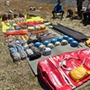
Equipment Quality and Check
All the gear used on our treks and expeditions is tried and tested, maintained for good quality, and is overall top-notch in quality and condition. We are continually looking to obtain the best of everything there is in the market so as to ensure optimum safety.
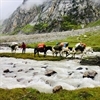
Support Systems
Along with the staff you see on-ground, we have a team of superheroes working in the background to give you the best experience possible. Our background team also comprises local staff from each area who know the region best. Having local support helps with studying the area, pre-planning, execution, and in receiving timely support in case of emergencies in these remote locations.
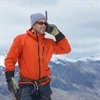
Communication
Our on-field staff is in constant contact with our teams based in primary locations so as to eliminate any avoidable delay in reaching additional help and support when required. We try to use the best tools for communication available, including satellite phones, in regions where they are not restricted.
What our customers Say

Cancellation Policy
Cash refund
Cancellations up to 30 days prior to departure date
5% deduction
Cancellations between 30 days to 15 days prior to departure date
50% deduction
Cancellations within 15 days prior to departure date
Voucher refund
Cancellations up to 5 days prior to departure date
No Deduction
Cancellations within 5 days prior to departure date
- Cash refund is applicable only in case of bookings made without using any promotional offer code or vouchers
- This is only a brief of cancellation terms. For finer details please refer Detailed Cancellation Policy.
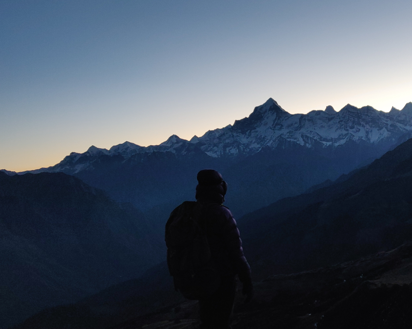
Subscribe for latest updates & offers
Similar adventures.
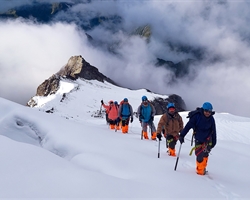
Friendship Peak Trek
A springboard for hardcore mountaineering.
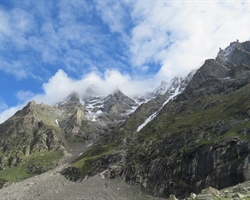
Jagatsukh Peak Trek
A perfect starting point to transition from trekking to climbing.
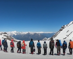
Buran Ghati Trek
Trek with the most thrilling rappelling experience, enter your email, events by categories.

Mountaineering

Scuba Diving
Events by months.
- January July
- February August
- March September
- April October
- May November
- June December
Events By Nights
- 5 & More Night
- Environmental Policy
- Privacy Policy
- Term & Conditions
- Work With Us
- Address: 303, 3rd Floor, Tower B4, Spaze Itech Park, Sector 49. Gurgaon
- Pre Sale - 8448680062 , Post Sale - 8588878499, 9667639126
Bikat Adventures
- Cancellation & Refunds
- Content Sharing

© 2024 Bikat Adventures - All Rights Reserved
Powered by: novel knett software solutions, submit enquiry.
Pangarchulla Trek
- Tour Packages
- How to Reach

- 2 Tour Packages
The Pangarchulla peak is a high altitude trek in the Joshimath region of Chamoli district in Uttarakhand . It is a moderate level trek that will take you on an expedition in the midst of the gigantic boulders, high peaks, long trails and in the midst of the gorgeous Deodar forests. The Pangarchulla Peak is at an altitude of 15069 feet.
Explore Pangarchulla Peak Trekking Guide, Tour itinerary, Tips
- Send Enquiry

Get Personalised Travel Quote
Contact us for a free travel quote and itinerary for your travel plans.
Pangarchulla Trek: Himalayan White Desert
At the Pangarchulla Trek, you will also find the Himalayan Bears & Leopards while you travel in the midst of the dense woods of the forest. The trek is a little demanding on the physical level but it is worth every drop of sweat that you shed. The view at the Pangarchulla hilltop is grand and majestic, loaded with the serene beauty and tranquility The Himalayas has to offer to you. The trail will take you through a landscape that changes with each uphill heave and downward scurry.
From the meadows to breathtaking Oak forests and Grassland, the Pangarchulla Trek has it all. Being in the way of the Nanda Devi Sanctuary so you will be able to have a sight of Mt.Nanda Devi, Chaukhamba, Donagiri, Hathi Parbat , Ghori Parbat, and many other majestic mountain peaks. The trek to Pangarchulla is a 6 to 9 days trek, depending upon your trekking guide.
Suggested Itinerary of The Pangarchulla Trek
Day: Haridwar –Auli (2450m) Distance: 8 to 9 hrs/ 280 km Travel till Haridwar through bus, train or an airplane as Haridwar is well connected to motorable roads, railways and airways across the entire country. From Haridwar it is a 282 kms drive to Auli . It is a fascinating journey that passes alongside the river Ganga and Alaknanda , passing through Rishikesh , Dev Prayag and Rudra Prayag . Stay overnight at Auli.
Day 2: Auli-Tali (3200m) Distance: 5 to 6 hrs Trek Drive around 5 km to reach at the starting point of the trek. Hike on the Auli meadows passing by the Nanda Devi Peak. Pass through dense and beautiful forest to reach till Gorson Bugyal , from there continue into another forest which is a huge collection of oak, deodars, maple and chestnut trees. Reach Tali and camp here overnight.
Day 3: Tali-Kauri Pass (3650m)-Base of Pangarchulla Peak (3650m) Distance: 6 to 7 hrs trek Keep walking from Tali to the Kauri Pass which is a 3 hour trek. You can go to another pass and have better views. Start moving towards the Pangarchulla Peak. Here you will witness some really amazing Himalayan ranges like Chaukhamba, Kedarnath , Neelkanth , Haathi-Ghodi, Kamet, Mana , Dronagiri etc. Stay overnight in tents.
Day 4: Base Camp (3650m)- Summit of Pangarchulla Peak (4700)-Khulara (3225m) Distance: 8 to 9 hrs trek Start trekking towards the ridge at the top. Its better to start early in the morning as you will be able to walk on hard snow. From this route to the summit you will be able to witness the view of mountain peaks like the Nanda Devi, Trishul, Changbhang and many more. After enjoying for a while you may start walking towards Khulara, stay overnight in tents at Khulara.
Day 5: Khulara-Dhak (2000m)-Auli Distance: 3.5-5.5 hrs trek/45 min Drive Start climbing down towards the road that linking Joshimath to Niti-Malari Valley . You will land up in Dhak, a bustling marketplace. You will face a lot of scenic stretches of forests and villages on your way. You can stop in the middle on your way to Tugasi and Karchi and indulge in the local culture of the place. From Dha drive till Auli. Stay overnight at Auli.
Day 6: Auli to Haridwar Distance: 280 km, 8 to 9 hrs drive Drive back to Haridwar from Auli, your trek will end here.
Best Time to Travel to Pangarchulla Trek
The Pangarchulla Trek is trek in the Garhwal Himalayas of Uttarakhand. It is a 6 to 9 days trek depending upon the trek guide you choose. The Best Season to Travel to the Trek to Pangarchulla is during the month of May to October. Even while you travel in May you will find the snow melting and unleashing the green and serene meadows which is a sight to gaze at. The difficulty level of the trek also depends on the travel month you choose.
Pangarchulla Trek is also known a Pangarchula Trek, Pangarchulla Summit Trek, Pangarchulla Peak Trek.
Pangarchulla Trek Photo Gallery

- Pangarchulla Trek Travel Guide
- Pangarchulla Trek Tour Packages
- How to Reach Pangarchulla Trek
- Pangarchulla Trek FAQs
- Pangarchulla Trek Photos
What is Pangarchulla Trek famous for?
Pangarchulla Trek is famous among tourist as Summit Trek, Winter Trek, Snow Trekking, Garhwal Himalyan views.
Pangarchulla Trek is recommended destination for Corporates, Couples, Foreigners, Groups.
Pangarchulla Trek is popular destination for following activities/ interests - Adventure , Trekking .

Pangarchulla Trek Highlights
- Amphitheater of Garhwal Himalayas
- Summit a Peak - 4700 mts
- Tali Tal - high altitude lake, High altitude Meadows
- Altitude Range: 1800 mts to 3850 mts
- Explore Auli Hill Station and Ski Resort
Pangarchulla Trek overview
- Starts from Dhak village, Joshimath
- Trek grade Moderate
- Trek duration 6 days days
- Altitude range 900 - 4572 mts
- Located in Chamoli, Garhwal
- Railway Station Rishikesh, 272 kms
- Nearest Airport Dehradun, 292 kms
- Famous for Summit Trek, Winter Trek, Snow Trekking, Garhwal Himalyan views
Get Package Details
Travelling to Pangarchulla Trek in 2024?
Contact us for planning your Pangarchulla Trek tour with best travel packages of as per your requirements!
- Char Dham Yatra
- Char Dham Packages
- Chopta Tourism
eUttaranchal
- Uttarakhand
- Uttarakhand Tourism
- Uttarakhand Tour Packages
- Uttarakhand Hotels
Customer Service
- Return, Cancellation & Refund
- Privacy Policy
- Terms of Use
Business Connect
- List your Package
- List your Hotel
- Send Feedback
.png?w=auto&h=400 "pangarchulla trek distance")
Pangarchulla Peak Trek
Pangarchulla peak trek overview.
If you're searching for a challenging and spectacular summit ascent, the Pangarchulla Peak trek is for you. The Pangarchulla trek's peak is located at the height of 15,069 feet.
The Pangarchulla mountain is a high elevation trek in Uttarakhand's Chamoli district's Joshimath area. It is a low and moderate trek which will lead you on an excursion across massive rocks, high hills, lengthy routes, and lovely Deodar forests.
Pangarchulla is a 5-day journey to begin with and 6 days when you include the travel days from Haridwar. The walk begins at Auli, near Joshimath in the Garhwal area of Uttarakhand located in the Nanda Devi National Park.
The path to Pangarchulla & Kuari Pass stays consistent until the final day. You have a better sight of Nanda Devi to the left and the pinnacle of Pangarchulla to the right as you drive to Dhak, the head path for this incredible summit, which sits atop a deep forest packed with pine trees. It's a short trek that packs a lot into its six-day duration. The Pangarchulla peak trek brings you to a variety of scenery producing all sorts of enchantment in a very short period of time, from little communities to dust paths leading to large open meadows, lush woods, clean streams, and rocky sections plunging into something like the snow.
Book Pangarchulla Peak Trek Package
Pangarchula peak trek with kuari pass, quick facts of pangarchulla peak trek.

Maximum altitude - Pangarchula summit is 14700 feet (4500 metres)
Grade - Moderate to Difficult.
Duration - 6 Days
Trekking distance - 44 kms
Trail type - The summit offers 360-degree views of Himalayan peaks such as Mt. Nanda Devi, Hathi Parvat, Ghodi Parvat, Kamet, and Dronagiri.
Rail head - Rishikesh Railway Station
Airport - The closest airport to Haridwar is Jolly Grant Airport in Dehradun. From Mumbai or Delhi, travellers can fly directly to Dehradun, or they can take a connecting flight from any location in India. You may hire local automobiles outside of the airport to go from Dehradun to Haridwar via road.
Snow Season - Temperature will be around 18°C to 12°C during the day time and in the night -3°C to -6°C
Service from - You may take a bus or a cab from Haridwar to Joshimath. Transportation will be available at an additional fee.
Best season - The optimum period for a Pangarchulla hike is between March and April, when the path is covered in ice and snow and between October and November.
Who can participate: The Pangarchulla peak trek is suitable for experienced trekkers and those who have already completed moderate level climbs. If you are a novice who is serious about training, you will require a minimum 2-3 months to get prepared physically and psychologically for Pangarchulla.
Short Itinerary for Pangarchulla Peak Trek
Day 1: Haridwar to Joshimath drive (6,750ft, drive of 256 km, 9 hour)
Day 2: Drive 10 kilometers from Joshimath to Dhak village. Then walk 6 kilometers uphill to Gulling.
Day 3: Guling to Kuari Pass, 5 hours; descend to lower Khullara camp, 12 km; 6/7 hours total.
Day 4: Lower Khullara to Pangarchulla top (15069 ft), 6 hours, then return to lower Khullara - total distance 12 km, 10/11 hours.
Day 5: Lower Khullara to Auli via Gurson Bugyal - 10 km - 5/6 hours - drive to Joshimath - 45 minutes / 14 km
Day 6: Joshimath-Haridwar Drive (6750 ft, drive of 256 km, 9 hour)
Pangarchulla Peak Trek Detailed Itinerary

Haridwar to Joshimath
- Altitude - 6,750 ft
- Drive: 256 km
Duration - approx 9 hours
Trekkers will be collected at Haridwar at 6:30 a.m. in either a Tata Sumo or a comparable vehicle (cost not included). Arrive in Joshimath about 5 p.m. where you can have tea, briefing of the trek & dinner.
On the road, breakfast and lunch (exclusive of charges)The guest house will provide you with lodging.

Joshimath to Gulling
- Trek Distance: 6 km,
- Camp elevation: 9,650 ft.
- Time required: around 6 hours
Trek Grade - Moderate
Begin your morning with a delicious breakfast and then travel 10 kilometers to the place where you may begin trekking to Guling.
Climb down to reach another thicket of Oak, Chestnut, Deodar, and Maple trees.
Continue going on the route and you will see the magnificent Dronagiri mountain, that will also make your heart skip a beat, and subsequently we will arrive at Gulling top, our destination for the day.
Set up camp in tents here and relax for the night.

Guling to Kuari Pass
- Altitude - 11,100 ft
- Trek Distance - 12 Km
- Elevation: 11,070 ft Time spent: around 10 hours
Trek gradient: Moderate
Begin with an early breakfast before beginning your Kuari pass hike, which will take you up fields painted in various shades of green and populated with herdsmen and their sheep grazing.
Continue climbing for yet another three hours to get Kuari Pass.
After that, descend to the base camp of Pangarchulla mountain, from which you can see Chaukhamba, Kedarnath, Neelkanth, Haathi-Ghodi, Kamet, Mana, and Dronagiri.
Set a tent in the lower khullara camp at the base camp.

Lower Khullara (11,100 ft) to Pangarchulla top (15069 ft)
Trek distance - 12 km
Altitude - 15,069 ft
Grade - Moderate to difficult
Return to lower Khullara
Start your day off early, around 5:00 AM, with a filling meal, and then set out on your walk by climbing mountain slopes until you reach a ridge that will take you to the peak.
The Mt. Nanda Devi, Trishul, and Changabhang peaks are a visual treat along this path to the Pangarchulla peak trek.
Before continuing your descent to the camp, take some time to bask in the wonders.

Lower Khullara (11,100 ft) to Auli (8600 ft) through Gurson Bugyal
Trek Duration - 5 to 6 hours
Trekking Distance - 10 kilometers
Drive Duration - with 45 minutes to drive to Joshimath.
Altitude - 11000 feet
After a hearty breakfast, set off on a hike in the direction of the route connecting Joshimath and the Niti-Malari valley.
Hike through thorny bushes and quaint towns together all the way to Gurson Bugyal. To understand more about the residents and their traditional culture, you may even stop by the towns of Tugasi and Kharsi.
Drive to Joshimath, where your lodging is waiting for you with a hot lunch and a hot shower. You are welcome to live here.

Joshimath - Haridwar Drive
After breakfast, depart from the Pangarchulla Peak Trek across the icy surroundings and drive down to Haridwar.
Mother Nature and her magnificence in your spirit and mind which has inspired you during the entire voyage, are the only things that will remain constant along the journey.
Continue to your destination to complete this thrilling Pangarchulla Peak hike through Kuari Pass.
Note: The Pangarchulla mountain climb and a trip to the genuine Kuari pass are both included in our 6-day programme. However, in addition to the amount of snow and the weather, it also depends on how well the team performs.
What to Pack for Pangarchulla Peak Trek?

- Winter Jacket
- Toilet paper & wipes
- Walking stick
- Back pack (50-60l)
- Water bottle
- Fleece jackets and thermals
- Hiking shoes
- Mosquito & insect repellent
- Thermal inners
- Waterproof windcheater
- Woolen cap, socks, mittens & scarf

Pangarchulla needs robust hiking boots with adequate traction, ankle support, and snow-handling capabilities.
A 50 to 60 litre backpack is required for a hike like Pangarchulla. Ensure your backpack has strong shoulder and hip supports as well as quick-access compartments.
In the mountains, it's important to layer your clothing. You are best protected from the cold by wearing layers.
Carry two t-shirts and wear one. Keep full-sleeve dry-fit T-shirts on hand (preferably collared). These protect your arms & neck from becoming sunburnt. Throughout the walk, especially at high altitudes, in the rarified air
You will require 1 set of inner thermals, a padded jacket, a few light fleece layers, and 1 light sweater. Don't buy your grandmother's knit sweaters since they can be exceedingly hefty. Sweaters and fleece coats are necessary.
For this journey, two pairs of trekking pants should be plenty. Carry one pair if it rains and wear one pair. Trekking is a great time to wear pants featuring zipper cut-offs at the thighs.
Snow blindness may be avoided using sunglasses. Through a hike like Pangarchulla, you may anticipate walking on extensive snowy terrain and snow blindness can result from exposure to bright sunlight reflected through snow.
A sun hat is required. Without a sun cover, hiking can result in headaches, sunburns, rapid dehydration, and a significant decline in hiking performance.
You need the mittens to keep you warm on a trek like Pangarchulla. Purchase synthetic hand gloves with an inside cushioned lining and an outside waterproofing.

The forest department needs these records for legal reasons. You won't be able to hike without any of these.
- Original and photocopy of a government identity card
- Disclaimer Certificate
- Medical Certificate
Know Before You Go to Pangarchulla Peak Trek

One of the greatest Himalayan summit treks one may take in April is to Pangarchulla Peak. Technically speaking, the 14,700-foot summit is not a behemoth. A careless attitude, though, can lose you the well-deserved summit glory. Take into consideration the tips and suggestions to increase your possibility of attending the Summit.
Trekkers must always have a photocopy of their picture ID with them while entering the forest checkpoints.
Your lodging will be organized in lodges at the base camp.
You will spend three nights in a tent while on the hike.
At the base camp, we provide a cloakroom for extra luggage. Keep your valuables out of the cloakroom.
Please be aware that twin-sharing tents might not be offered. This is due to the fact that various nations supply the basic materials used to make tents.
However, because of the upheaval across the world, their export has suffered. Tents are now in limited supply everywhere as a result.
Despite this, you will still have plenty of room as these tents are made to fit three hikers.
Check the snow conditions with your guide and time your trk=ek according to the fall of snow.
Carry all the trek gears you will need to carry as there might be a time when the ponies won’t be available.
Make an early start to the day and plan your summit according to the proper time as it takes 7 hours to reach.

Driving from Joshimath to Rishikesh
Drive: 254 kilometers
Drive 10-12 hours through Joshimath to Tugasi via car.
From Tugasi, hike to Gulling or Akhrot GhettaTrekking distance: 12 kilometers Altitude Gain: 8,790 to 10,908 feet during a period of 6-7 hours
Trek to Khullara from Gulling or AkhrotghettaTrekking distance of 6 km, time required for the trek, and elevation gain of 10,908 to 11,010 feet
Khullara's Acclimatization Day. Trek back to Khullara after visiting Kuari Top7 km, 4-5 hours, with an elevation gain and loss of 11,010 feet to 12,600 feet before returning to 11,010 feet.
Trek to Pangarchulla Summit from Khullara and then return.Trekking across 12 kilometers for 10 to 12 hours with an elevation gain and loss of 11,010 feet to 15,069 feet before returning to 11,010 feet.
From Khullara, hike to Karchi, then take a car to Tapoban and head back via Tapoban to Rishikesh Driving Range: 260 km | Hike Duration: 10–11 hours Altitude Loss: 11,010 feet to 7,315 feet Trek Length: 5.25 km | Traveling Duration: 3–4 hours
Depending on the weather and the path you follow, the length between campsites might change by 100 meters. For identical reasons, the altitude may likewise change by 100 feet.

By Air: The closest airport to Haridwar is Jolly Grant Airport in Dehradun. From Mumbai or Delhi, travelers can fly directly to Dehradun, or they can take a connecting flight from any location in India. You may hire local automobiles just outside of the airport to go from Dehradun to Haridwar via road.
By Rail: Arriving at Haridwar By Train: There are regular trains from Delhi to Haridwar Railway Station in 4-5 hours & Dehradun (1 hour). Additionally, a few trains run to Rishikesh each day.
By Road: Since there are good bus connections from all major towns and cities to Haridwar, travelers may go there as comfortably and at their leisure. The distance between Chandigarh and Delhi is 205 kilometers.

Only April offers access to the Pangarchulla Peak trip which is the spring season. The other seasons are not favorable for the trek hence it remains closed. As the route contains too much snow before April, the summit ascent is not feasible.
Following April, the snow fades away, making the summit climb hazardous due to exposed stones. These stones are large and have several gaps among them, making it difficult for any hiker to pass between them. It is quite hazardous as well as quickly exhausted. Due to these factors, it is recommended to make the ascent before the snow melts. The mountaintop climb is best accomplished during this brief window, even though the remainder of the path is accessible for approximately 8 months out of the year.
On the Pangarchulla trek in April, it is officially Spring. At this moment, lovely meadows are emerging as the snow begins to melt. Although there is little snow in the campgrounds, there is a lot of newly fallen, heavy snow over 12,000 feet. This is the ideal quantity of snow needed to make it easier to reach the top. Concluding that spring provides a best of both worlds where the ideal timeframe for mountain ascents and the season to view new blossoms. The journey is only accessible and secure during this period.
General Trivia About Pangarchulla Trek

The origin of the word Pangarchulla is a fascinating tale. The direct translation of this name, Pangarchulla, describes how it seems to be a chimney surrounded by maple trees. Chulla signifies a chimney, and Pangar means "maple," which alludes to maple trees.
A flower called Saussurea Obvallata, also known as Brahma Kamal, grows in the Himalayan alpine meadows over 14,000 feet. On the reverse side, you will see wide meadows covered in Brahma Kamal flowers, about 1,000 feet below Pangarchulla Peak. Many locals climb Pangarchulla "barefoot," go through the meadows to gather these flowers, and then present them to their God. In many areas of Himalayan region, putting these flowers on one's person is a customary practice.
Tali Lake is situated exactly where high elevation meadows begin, at the ending of the treeline. It's breathtaking to see Mount Nanda Devi, Mount Dronagiri, as well as other mountains reflected in the lake.
The campground in Akhrot Ghetto is situated beneath a massive, ancient walnut tree. It derives its name from that. Akhrot is Arabic for walnut. You may see peaks including Hathi Parvat, Gauri Parvat, Mt. Barmal, Mt. Dunagiri, and Garud Parvat, among others, in awe-inspiring detail from this location.
Why to Go for Pangarchulla Peak Trek
The peak ascent is what makes this excursion famous. That will be the very first memory that comes to mind for anybody who has completed this way. You carefully feel your feet as you ascend over several pebbles coated in snow. The excitement and adventure are increased as you negotiate several challenging, precarious, and exposed portions while climbing high. On the summit day, you travel about 4,000 feet up and down to reach a height of 15,069 feet. This makes the voyage incredibly fascinating and full of adventures.
You May Also Book

FAQ's of Pangarchulla Peak Trek
What is the height of pangarchulla peak.
The height of Pangarchulla peak is 4575 meters.
How Difficult is the Pangarchulla Peak Trek?
The Pangarchulla Peak hike is classified as a challenging level 1 trek with - Difficult, steep routes - Ascends to approximately 15,000 feet - Trekking hours can exceed 9 hours per day - Few exit alternatives- Prior high elevation trek experience and excellent cardiovascular fitness are essential.
We believe that perhaps the Pangarchulla Peak trip meets all of these requirements. The hike reaches an elevation of 15,070 feet. The summit day might last up to twelve hours of arduous trekking up and down 4,000 feet in one day. The summit ascent is difficult, with steep, uneven, and exposed areas.The final four hour of the summit ascent are spent hiking on firm snow over boulders. It's really difficult, demanding, and full of hard spots. It necessitates being sure-footed, always vigilant, and bearing a lot of energy.
Aside from the initial 2 days, the remaining journey is distinguished by lengthy days, with a minimum of eight hours of trekking each day.All of this adds to the difficulty of the trip. This journey is very hard to complete without previous high altitude trek expertise and adequate physical preparation.
How many days does Pangarchulla trek take?
The number of days to complete Pangarchulla Trek depends on the guide that you take. Approximately it takes about 6 days to complete.
What are the nearest airports and railway stations for Pangarchulla Trek?
The nearest airport is the Jolly Grant airport while the nearest railway station is Rishikesh railway station.
Is offloading available on Pangarchulla Trek?
Keeping in mind the footprints that are left behind by porters and mules, it is best to not opt offloading but if there is any medical issue with someone, offloading is available for them with an additional cost.
What is the nearest ATM at Pangarchulla Peak Trek?
Joshimath is the last place where you will find ATMs but the chances of cash getting exhausted at Joshimath ATMs are high. Hence, it is recommended that you withdraw cash from Rishikesh itself.
Treks in Himachal
Treks in uttarakhand, treks in ladakh, treks in nepal, treks in north-east, treks in kashmir.
The content and images used on this site are copyright protected and copyrights vests with the respective owners.
© 2024 www.heyhimalayas.com All rights reserved.
- +91-8218331684
- [email protected]
- Your cart is empty
Pangarchulla Peak Trek

Specific Tour
About this tour
The Pangarchulla Peak Trek is an exhilarating and challenging journey through the mesmerizing landscapes of the Garhwal Himalayas in Uttarakhand, India. Known for its rugged beauty and demanding trails, this trek stretches over approximately 40 kilometers and is a thrilling experience for avid trekkers and adventure seekers.
Starting from the vibrant town of Joshimath, known as a gateway to several Himalayan expeditions, the trek unfolds a series of diverse landscapes. As trekkers advance, they traverse through enchanting oak and Rhododendron forests, sprawling meadows, and steep rocky paths. The trek’s ultimate challenge and reward is the summit of Pangarchulla Peak, perched at an impressive altitude of 4,700 meters (15,419 feet). Here, one is greeted with a 360-degree panoramic view of the Himalayan giants, including notable peaks like Nanda Devi, Kamet, and Chaukhamba.
The Pangarchulla trek is particularly renowned for its demanding nature, especially during the final ascent to the peak. This challenging section requires trekkers to navigate through steep and often snow-covered terrain, demanding good physical fitness, stamina, and mountaineering skills. The trek usually spans over a period of 6 to 7 days, offering an immersive experience in the heart of the Himalayas.
Quick Information on Pangarchulla Trek:
- Trek Duration: 6 nights/7 days
- Trek Difficulty: Moderate to Challenging
- Starting Point: Joshimath , Uttarakhand
- Best Time to Visit: April to June, September to November
- Highest Altitude: 4,700 meters (15,419 feet) at Pangarchulla Peak
- Trek Distance: Approximately 40 kilometers
- Temperature Range: Day: 10°C to 15°C Night: -2°C to 5°C
- Meals: Veg+Egg
- Accommodation: Tents and guesthouses
- Age Group: Ideal for ages 15-50 years, depending on fitness level
- Nearest Airport: Jolly Grant Airport, Dehradun
- Nearest Railway Station: Haridwar Railway Station
Short Itinerary for Pangarchulla Trek:
Day 01: Dehradun to Joshimath
- Altitude: Dehradun (1,410 ft) to Joshimath (6,200 ft)
- Drive Distance: Approx. 295 km
- Driving Time: 9-10 hours
- Activities: Drive from Dehradun to Joshimath
- Accommodation: Guesthouse in Joshimath
Day 02: Joshimath to Dhak to Guling
- Altitude: Joshimath (6,200 ft) to Dhak (6,867 ft) to Guling (9,408 ft)
- Trek Distance: 6 km (Joshimath to Dhak by drive, Dhak to Guling by trek)
- Trekking Time: 4-5 hours
- Meals: Breakfast, Lunch, Dinner
- Activities: Drive to Dhak, then trek to Guling
- Accommodation: Tents at Guling Campsite
Day 03: Guling to Khulara
- Altitude: Guling (9,408 ft) to Khulara (11,122 ft)
- Trek Distance: 4 km, Trekking Time: 4-5 hours
- Accommodation: Tents at Khulara Campsite
Day 04: Khulara to Pangarchulla Summit and Return
- Altitude: Khulara (11,122 ft) to Pangarchulla Peak (15,069 ft) and back
- Trek Distance: 12 km (round trip), Trekking Time: 7-8 hours
Day 05: Khulara to Dhak to Joshimath
- Altitude: Khulara (11,122 ft) to Dhak (6,867 ft) to Joshimath (6,200 ft)
- Trek Distance: 6 km (Khulara to Dhak), then drive to Joshimath
- Trekking Time: 5-6 hours
- Meals: Breakfast, Lunch
Day 06: Joshimath to Dehradun
- Altitude: Joshimath (6,200 ft) to Dehradun (1,410 ft)
Best Time to Visit Pangarchulla Peak Trek:
The Pangarchulla Trek, with its varying landscapes and climatic conditions, offers distinct experiences across different seasons. The best time to embark on this trek is typically during the spring months of April to June and the post-monsoon period from September to November. Here’s a seasonal breakdown:
Pangarchulla Trek in Spring (April to June):
- Weather: The spring season is characterized by moderately warm days and cool nights. The snow from winter starts to melt, but there’s still enough to make the summit challenge exciting.
- Landscape: This is a time when the flora in the region starts to bloom. Trekkers can witness a variety of flowers and lush green meadows, bringing a burst of color to the Himalayan landscape.
- Trekking Conditions: The melting snow can make some parts of the trail slippery, requiring careful navigation. However, the clear weather provides excellent visibility for breathtaking views of the surrounding peaks.
Pangarchulla Trek in Monsoon (July to August):
- Weather: The summer months, especially July and August, mark the monsoon season in the Himalayas. Trekking during this time can be challenging due to heavy rains and potential landslides.
- Landscape: The rain rejuvenates the greenery, but the cloudy and misty conditions can obscure views.
- Trekking Conditions: Not the most recommended time for the trek due to safety concerns and reduced visibility.
Pangarchulla Trek in Autumn (September to November):
- Weather: Post-monsoon, the weather stabilizes with clear blue skies and a pleasant climate. Night’s start getting colder as November approaches.
- Landscape: The clarity post-monsoon offers some of the best views of the Himalayan range. The landscape is still lush, and the air is crisp and clear, providing excellent trekking conditions.
- Trekking Conditions: Trails are usually dry and firm, making it safer and more enjoyable to trek. This is one of the best times to attempt the Pangarchulla summit.
Pangarchulla Trek in Winter (December to March):
- Weather: Winters are harsh with heavy snowfall and extremely cold temperatures, making it a challenging time for the trek.
- Landscape: The entire region is blanketed in snow, transforming the landscape into a white wonderland.
- Trekking Conditions: Only recommended for highly experienced trekkers with proper winter trekking gear and preparation. The beauty of the snow-covered landscape is unparalleled, but the risks are significantly higher.
Difficulty Level of Pangarchulla Trek:
The Pangarchulla Trek is generally classified as Moderate to Challenging, making it more suitable for trekkers who have some experience and are in good physical shape. The trek’s difficulty level stems from various factors:
Altitude and Acclimatization:
The highest point of the trek is Pangarchulla Peak, at an altitude of 4,700 meters (15,419 feet). The high altitude demands proper acclimatization to avoid altitude sickness. The gradual ascent helps, but the thin air at higher altitudes can be challenging for those not accustomed to it.
Trek Terrain:
The trek involves navigating through a variety of terrains, including dense forests, rocky paths, and snow-covered trails (especially during spring). The final ascent to the summit is particularly steep and can be covered in snow, requiring careful footing and additional mountaineering skills.
Weather Conditions:
Weather in the Himalayas can be unpredictable. Trekkers might face strong winds, cold temperatures, and sudden weather changes, which can add to the challenge.
Distance and Duration:
Covering approximately 40 kilometers, the trek demands long walking days with substantial elevation gain and loss. The physical demands of trekking for several days in a row, often for 6-7 hours each day, require good stamina and endurance.
Read how to get fit for Himalayan trek.
Meals and Accommodation during the trek
Where You’ll Stay:
- In Joshimath: Think of Joshimath as your first stop. It’s a small, cozy town and that’s where we’ll be staying before we start hiking. The places here are pretty basic – you might share a room with a couple of other trekkers, or stay in a dormitory-style room.
- On the Trek: Once we’re on the trek, we’ll be camping in tents. These tents are roomy and comfortable, perfect to crash in after a day of trekking. We’ve got different tents for different group sizes, and if you’re a woman trekking with us, don’t worry, we have separate tents for female trekkers for your privacy and comfort.
About the Food:
- We start serving food from dinner on the first day all the way through to breakfast on the last day.
- Expect to get all your meals – breakfast to start your day, lunch to keep you going, and dinner to relax after a long day. Plus, we have evening tea with snacks, and even some hot soup to warm you up.
- Every meal is a bit different, and we even throw in different desserts daily, so you’ll have something new to try every day.
- We make sure you have plenty of hot water to drink at the campsite. Staying hydrated is super important, especially to help you adjust to the higher altitude and keep you feeling good during the trek.
How to Reach Joshimath for the Trek
To facilitate a stress-free start to your trek, we advise arriving in Rishikesh a day before the trek begins. Our journey to the trailhead starts early from Rishikesh, with a scheduled pickup at around 6 am.
Traveling to Rishikesh:
- By Air: Arrival at Dehradun Airport
- The closest airport is Jolly Grant Airport in Dehradun.
- From there, you can either hire a taxi or use bus services to get to Rishikesh. This trip usually takes about 45 minutes to an hour.
- By Train: Arrival at Rishikesh or Haridwar Railway Station
- Rishikesh is served by its own railway station. Upon arrival, you’ll find numerous auto-rickshaws and taxis to take you to your destination in Rishikesh.
- Alternatively, you can arrive at Haridwar Railway Station and then travel to Rishikesh by taxi or bus, a journey that typically takes 45 minutes to an hour.
- By Bus: From Major Cities
- Regular buses connect Delhi, Haridwar, and other nearby cities to Rishikesh. The bus ride from Delhi to Rishikesh can take about 6-7 hours, varying with traffic and bus type.
Direct Route to Joshimath:
- For direct access to Joshimath, consider hiring a taxi or driving yourself.
- The road trip from Rishikesh to Joshimath spans about 250-260 kilometers and takes around 9-10 hours, offering scenic views and winding mountain roads.
Transportation from Rishikesh to Joshimath:
- Participants of the trek with Nomad Adventures will be transported in sturdy vehicles such as Boleros, Tata Sumos, and Travelers from Rishikesh to Joshimath.
For a smooth and memorable experience on your Kuari Pass Trek with Nomad Adventures, it’s recommended to plan your arrival in Rishikesh well in advance of the trek start date. Safe travels and prepare for an incredible adventure in the mountains! 🏔️✨
Packing List: What to Bring on the Trek
Being well-prepared with the right gear and supplies is crucial for a successful and enjoyable trek. Here’s a comprehensive packing list for the Pangarchulla Trek:
Essential Gear:
- Backpack: A sturdy, 50–60-liter backpack with comfortable straps.
- Trekking Shoes: High-ankle, waterproof, and well-broken-in trekking boots.
- Walking Stick/Trekking Poles: For additional support and balance.
- Thermal Layers: Top and bottom base layers for insulation.
- Trek Pants: 2-3 pairs of quick-dry trekking pants.
- T-Shirts: Breathable and moisture-wicking fabric; include both short and long sleeves.
- Fleece Jacket: A mid-layer fleece or woolen jacket.
- Insulated Jacket: A down or synthetic insulated jacket for colder conditions.
- Outer Layer: A waterproof and windproof jacket for harsh weather.
- Socks: Woolen or synthetic hiking socks, plus a few pairs of lighter socks.
- Hat and Gloves: Woolen or fleece hat and waterproof gloves.
Personal Items:
- Sunglasses: UV-protection sunglasses.
- Sunscreen & Lip Balm: High SPF sunscreen and UV-protected lip balm.
- Toiletries: Basic personal hygiene kit (toothbrush, toothpaste, wet wipes, hand sanitizer, etc.).
- Headlamp/Flashlight: With extra batteries.
- Water Bottles/Hydration Packs: At least 2 Liters capacity.
- Personal Medical Kit: Basic first aid, any personal medications.
Miscellaneous:
- Camera and Power Bank: For capturing memories and charging electronics.
- Plastic Bags: For waste and keeping wet clothes.
Important Tips:
- Layering: Dress in layers to easily adjust to changing temperatures.
- Keep it Light: Pack only essentials to keep your backpack light.
- Waterproof Everything: Use waterproof bags or covers to protect your gear.
- Break in Your Boots: Make sure your trekking shoes are well broken in to avoid blisters.
Remember, the key is to stay warm, dry, and comfortable. Every item you pack should serve a purpose. Always check the weather forecast and consult with your trek leader for any specific gear requirements.
Clock/Baggage Room for Extra Luggage:
You can use the luggage storage at the Sankri base camp for extra items before starting the Kedarkantha trek. Avoid storing valuables there for safety.
Trek Tips to Ensure a Safe Journey on the Pangarchulla Trek:
- Acclimatization: High-altitude treks like Pangarchulla require your body to gradually adjust to the altitude. Take it slow, especially during the initial days, to reduce the risk of altitude sickness.
- Itinerary Flexibility: Be ready to adapt to changes in the trek itinerary due to weather conditions, health issues, or other unforeseen circumstances, always prioritizing safety.
- Medical Consultation: It’s advisable to consult a doctor before embarking on the trek, particularly if you have pre-existing health conditions. Carry essential medication and a comprehensive first-aid kit.
- Power Banks: As electricity might be scarce or unavailable at higher altitudes, bring adequate power banks to keep your devices charged.
- Eco-Friendly Mindset: Preserve the pristine nature of the Himalayas. Avoid littering, use biodegradable products, and practice water conservation to protect the environment.
- Sufficient Cash: ATMs will be inaccessible during most of the trek, so carry enough cash for any purchases or emergencies.
- Night Trek Precautions: Night trekking should be avoided unless specifically included in the itinerary and supervised by an experienced guide.
- Earphone Caution: Refrain from using earphones during the trek. It’s important to be alert and able to hear instructions or warnings from your guides.
- Plastic-Free: Support environmental conservation by avoiding plastic bags. Use reusable bags and containers.
- Guide’s Guidance: Always listen to and follow the instructions of your trek guides. Their expertise and experience are invaluable for a safe trekking experience.
- Cancellation Notice: If you need to cancel, inform the trek organizers or authorities well in advance. This helps in managing logistics and avoids confusion.
- Light Packing: A light backpack can significantly improve your comfort and mobility during the trek. Pack only the essentials.
- Age Consideration: The high altitude and strenuous nature of the trek make it unsuitable for children under 6 years old. Assess the capability and fitness of older children and teenagers.
- Avoid Intoxicants: Alcohol and other intoxicants can impair judgment and physical ability. It’s best to avoid them to ensure your safety and that of others.
- Trek through lush rhododendron and oak forests rich in flora and fauna.
- Gigantic peaks including Hathi Parbat, Ghori Parbat, Chaukhamba, Neelkanth, Mt. Nanda Devi and many more.
- Explore charming mountain villages like Dhak, Tugasi, and Joshimath.
- Conquer the 14,700-foot summit for stunning panoramic views.
Included/Excluded
- Food as per menu on the trek.
- Tents, Sleeping bags, mats.
- Forest permits and camping fee.
- Trek guide, cook, support staff
- Porters/mules to carry trekking equipment.
- First aid medical kit, oxygen cylinder and UIAA certified safety equipment.
- Trek Certificate
- Experience that you will gain
- Any kind of personal expenses on the trek.
- Transport is available from Rishikesh at an additional cost.
- Meal during road journeys.
- Mules or porter to carry personal luggage.
- Any kind of travel insurance.
- Anything not specified in the inclusion list.
- Note* If you don't want to carry your backpack ? you can give it to porter/Mules?, but you have to inform us in advance and have to pay Rs. 1200/- extra per bag for the whole trek.
Frequently asked questions
Will there be water sources on the way will two liters of water be enough.
Our campsites are pitched near water sources. For your day’s trek, two liters of water should be enough. You will find water sources on the trek to refill your water bottles. Your trek leader will brief you about these before starting the day’s trek.
What is the washroom/toilet facilities like on the trek?
During the trek, toilet tents will be set up along each campsite. A toilet tent will have a deep pit, where one can answer nature’s call. There will be a mound of soil and a shovel to cover it up. These are dry toilets, where you’ll have to use toilet paper. This is the most hygienic and convenient way to answer nature’s call in the wild. Please use plain toilet paper and refrain from using wet wipes since these are not biodegradable.
What if it rains while trekking?
If it starts raining while you’re trekking, we will continue on the trail as planned. Your poncho should protect you from the rain. Carry a backpack cover for extra protection from rain for your belongings.
When it gets really cold can I consume alcohol?
Alcohol is dangerous in extreme cold, especially at high altitudes. Contrary to what people believe, alcohol does not make you warmer. Instead, it opens your pores, making your body colder. Moreover, it dehydrates you very quickly. Hence consumption of alcohol is absolutely prohibited on all Nomad Adventures treks. Anyone found with alcohol is quickly removed from the trek. Smoking, similarly, is not allowed on Nomad Adventures treks.
Are trek poles, jackets and other equipment available for rent from Nomad Adventures?
No, but there are shops on the base camp from where you can rent shoes, jackets and trek poles, headlights etc.
Do I need special snow shoes on this trek?
You don’t need special snowshoes. A good waterproof trekking shoe is sufficient for the trek. When there is snow, we provide micro spikes and gaiters.
Why is the trekking pole necessary?
A trekking pole gives you stability and balance and helps reduce fatigue.
What is the age limit?
The minimum age limit is 8+ years. However, minors aged between 8 to 17 should be accompanied by their parents and guardians.
Can I take my child along on this trek?
Pangarchulla Peak Trek is a moderate to difficult level trek and it requires trekkers to be physically fit. The minimum age eligibility is 8+ years. As a parent or guardian, if you feel that your child can adapt to the conditions of the mountains and would be able to walk every day as required, then indeed, yes!
Is there a mobile network on this trek? And, what about charging points?
The last electricity charging point would be in Joshimath. You’ll get only the Bsnl or Mtnl with a 4G network in Joshimath. However, come prepared for the possibility of power cuts. It is good to carry your power banks and extra batteries for your camera.
I am solo female trekker. Do I need to share a tent with a male?
No, Female Trekkers share Room/Tent with female co-trekkers and the same applies to others.
Is it safe to trek with Nomad Adventures?
All high-altitude treks come with their share of risks. We pay utmost importance to the safety of trekkers. While we do our bit to ensure a trekker is safe, we also expect any trekker who is enrolling with us to know what could go wrong, and if it does, how to tackle it.
Can I leave travelling clothes behind and collect them after the trek?
Since you will be starting and returning to Manali, it is possible for you to leave some luggage behind. Please ask your respective homestay/hotel owners to provide some space for extra luggage.
Is Diamox advisable?
No, but in case you are having so please consult your doctor because there are lots of myths about Diamox.
Tour's Location
Write a review, leave a review cancel reply.
Your email address will not be published. Required fields are marked *

Member Since 2022
or continue with
Enter the e-mail address associated with the account. We'll e-mail a link to reset your password.
You will receive an email containing a link allowing you to reset your password to a new preferred one.
Verification mail has been sent.
Please check your mail to verify your account.
Click Here to Login
- How To Reach
30°25'26.6"N 79°35'29.4"E
- Pangarchulla Summit Trek

April-May, Sept-Dec
Joshimath, Uttarakhand
Pickup Point
Railway Station - Dehradun
Minimum Age
Pangarchulla Trek is a difficult and challenging trek to start and is not advised for beginners.
The summit climb is ecstatic which has a trail covered with deep snow, passing through some alluring views which can't refrain an individual to stop and stare at the beauty it holds in and around itself.
The views in the vicinity are astounding. You will witness the snow-laden mountain peaks namely Nanda Devi, Hathi Parbat, Dunagiri, Ghori Parbat, Chaukhamba. This is certainly a treat for the eyes.
Pangarchulla Trek
Pangarchulla trek elevation is encircled around 15,070 feet. It incorporates a total distance of approximately 38 kilometers and demands around 7 days to comfortably complete the trek along with acclimatization. Pangarchulla Summit Trek difficulty level is actually considered to be challenging and hence it comes under the moderate to difficult trek category.
Uttarakhand is one of the most visited states in India when it comes to spirituality and tourism. Uttarakhand doesn't end here, along with all this, it serves as a hub for adventure sports and trekkers from all over. Right from the high altitude juggernaut mountains to the pristine water bodies, this place has a lot to offer for the wanderlusts and nature lovers. Trekking in Uttarakhand is so amazing that the landscapes in the vicinity will certainly leave you speechless. Trekkers and adventure lovers from all parts of India visit this place and return back with a happy heart and calm soul. Out of all the alluring treks in Uttarakhand, Pangarchulla Trek is one of the most beautiful treks which you should certainly experience once in your lifetime.
Brimming with adventure, serenity, and beauty, the Pangarchulla trek lures in herds of trekkers every year. Replete with mesmerizing forests and blooming rhododendrons, the trek climbs up to views of some of the tallest mountains in the Garhwal Himalayas. The initial trail winds through verdant forests which house numerous enchanting floral species crisscrossing the ground, while as you climb higher up, you can treat yourself to a pristine carpet of powdery snow. The undulating terrain of the trek trails through dense oak forests and high altitude pastures that fill you with instant joy! The trek may demand that you struggle your way through a fair share of boulder for impressive rewards! The thrilling summit climb is truly surreal and sets your heart racing as you hustle through toil through boulders and deep snow. What awaits you at the end of a challenging climb are literally breathtaking views of the grandest Himalayan peaks that fence you.
The best time to scale the Pangarchulla Trek is from March to May and then again before the start of winter i.e. from September to October. This is because, during winters, we can envisage heavy snowfall, which will make the trek even more difficult. During summers (April - May), the temperatures will fall between 12 to 20 degrees, while it can drop as low as -5 degrees in the night. There will be an accumulation of snow on the meadows at high altitudes and on the Pangarchulla summit as well. The melting of snow takes place in the month of May. So, people visiting it during the months of April and May must be aware and prepared for the snow conditions. Pangarchulla in summer months is considered to be quite relieving if you live somewhere in the plains where the temperature tends to hit half-centuries. Pangarchulla Trek is not preferable during the monsoon months from July and August because of steep slopes and slippery terrain which makes it very difficult to ascend with the rain pouring downwards. Post monsoon months of October and November see a further 3 to 5 degrees drop in the temperatures.
This trek will end up being an ordeal for the beginners. The level of this trek leans more towards difficult, which naturally demands exceptional physical fitness, stamina, and endurance. It is strongly advisable to have prior trekking experience of scaling at least 11,000 feet before you approach this trek, which means beginners should stay away. The risk of developing altitude sickness is also high because of the high altitude. This is why teenagers can easily opt for this trek. Also, proper acclimatization is key for the successful completion of the trek.
Pangarchulla Summit Trek with Trekmunk will be a wonderful experience for all the wanderlusts. As per the reviews of various trekkers, Trekmunk is the best trekking company in India that assures you a quality service and a friendly atmosphere. Pangarchulla trek cost is 12450 INR which will include all the transfers from base camp, accommodation, meals, and an experienced trek guide. We here at Trekmunk aim to provide you with the cheapest and quality Kedarkantha trek. We need to show some documents of identification of trekkers to the forest department officials in order to get the Pangarchulla trek Permit. So, make sure that you carry the required documents that are mentioned on our site.
Brief Itinerary
Detailed itinerary, day 1: arrive at lata from dehradun.
We will arrange a pick up for you from the Dehradun Railway station early in the morning that shall take you to Lata. The distance of the whole journey from Dehradun to Lata is around 293 Kms journey and it will take approximately 8-10 hours to reach Lata via road. The 8-hour journey from Dehradun to Joshimath will be exhausting but throughout the trail, you will never run out of alluring views, so don't sleep as you might miss out on a view that you will cherish forever. Treat your eyes to great views of the endless forests and yawning valleys of Garhwal route. We will come across many confluences of rivers and spectacular landscapes all along the drive from Haridwar to Lata.
Lata, home of the misty valleys and lofty peaks is the base village for the trek. We will reach Lata before 06:00 pm. You can go out exploring the place in the evening. Enjoy the local culture and delicacies and return back to our stay. We will spend the night at Lata and start our trek to Akhrotgetta the following day.
Day 2: Drive to Dhak; Trek to Akhrotgetta
We will try to start the second day of our trek as early as possible. The morning breakfast will be served at the campsite. After breakfast, we will drive to Dhak village. The distance from Joshimath to Dhak village is around 12 kilometers and it takes around an hour of drive to reach Dhak village via road. During this drive, you can look out for the Sleeping Lady Mountain with gentle slopes running through a long distance. The actual trek via foot starts from Dhak village.
We will start our trek from Dhak Village to Akhrotgetta. It takes around 4 to 5 hours to complete the required distance. The trail is a mixture of gradual and steep ascent which passes through a lot of villages. These villages will serve as water points and we can refill the water bottles from here. You will also find a few streams with clean and clear gushing water that can replenish the water supplies. The majestic Mt. Nanda Devi greets you with a sprawling embrace at the start of the trek. The whole trek from Dhak village to the campsite will pass through delightful surroundings comprising of hemlock, oak, and rhododendron forest. These magical forests merge with the stunning Gorson Bugyal, a beautiful wide meadow, shadowed by the neighboring peaks Moving ahead, you will witness the mesmerizing sight of the bright sun-kissed Dronagiri peak. There lies a splendid snow-capped ridge from where you can witness the elegant Chaukhamba peak. There are few other peaks such as Hathi Parvat and Gori part which also assures breathtaking views from the trail. Passing through open meadows and oak forests, we will reach Akhrotgetta.
Once we reach the campsite we will stay overnight. Dinner will be served at the campsite. Tents will be pitched and fun activities will be organized.
Day 3: Trek from Akhrotgetta to Khullara
We will be starting the day early with a few minutes of yoga and healthy exercise. After having breakfast at the previous campsite, we will advance to Khullara. The altitude of Khullara is around 11,100 feet. It takes around 5- 6 hours to reach the Khullara campsite.
The complete trek distance from Akhrotgetta campsite to Khullara campsite is around 7-8 Kilometres through some green vegetation and really beautiful serene beauty of the hills. The whole trail comprises of dense mountain forests covered with rhododendrons, silver birch and spruce. The magnificent alpine meadows will fill your heart with joy. An uphill trek covering 3 kilometers will take us to lush green meadows where there are well-composed tracks from Tapovan. The panoramic landscapes, wide lush green pastures, frozen ice valleys, and a thrilling advancement of the trail make this journey a memorable one. The last water point is at Forest Hut which is at an elevation of 9,840 feet. The next ascent is quite steep as it connects the forest Hut to Khullara which is located at an elevation of 11,100 feet. You can witness a bunch of snow-clad mountains peaks from here. The mesmerizing views of Nanda Devi, Dronagiri, Hathi Parvat, Gori Parvat, and Chang bang will take make you wonder about your existence.
A walk of few distances along a gradual descent will take you to the Khullara campsite. The tents will be pitched, evening snack and tea will be served as you create memories that will last for a lifetime. This will mark the end of day 3. The next day, we will advance to Gailgad from where our destination will become even more closer.
Day 4: Trek from Khullara to Gailgad
We will be starting the day early. After having a healthy breakfast at Khullara, we will advance to Khullara. The altitude of Gailgad is around 12476 feet. It takes around 3 to 4 hours to reach the Gailgad campsite.
From the Khullara campsite, a beautiful forest ridge linking the Lord Curzon Trail snakes along a frozen stream. This part of the trek is blanketed by deep snow. A steep ascent brings you another bridge to climb, revealing a gully right above you. This climb is stiff and steep as you trudge through the powdery snow, moving past the forest line. Another 45 minutes will land you atop the snow gully, where the trail veers to the right and commands views of the massive Pangarchulla peaks. Stick to the right side of the ridge, and continue trekking for about 45 minutes. This is the Advance Base Camp for the trek. On the top of Gailgad, you can enjoy the view of Himalayan peaks including Nanda Devi. There are numerous other elegant mountain peaks namely Kedarnath Peak, Kedar Dome, Chaukhambha, Balakun, Neel Kantha, Mukut Parvat, Kamet, Abhi Gamin, Mana I, Ghori Parvat, Hathi Parvat, Dronagiri, Kalinka, Chang Bang, and Nanda Ghunti. You will feel like you are in heaven being surrounded by these many mountain peaks in the vicinity. We will spend some time embracing the beauty of the setting and glorifying the magnificence of nature.
We will set camp here for the night. Dinner will be served at the campsite. Tents will be pitched and fun activities will be organized. The following day will be the day when we will trace the Pangarchulla summit and make history for ourselves.
Day 5: Trek from Gailgad to Pangarchulla Summit and back
The most exciting and awaited day of the trek. This is also the toughest day of the whole trek. We will trek to the Pangarchulla summit which is at an elevation of 15,070 feet from the mean sea level. It will take approximately 10-12 hours to complete the scheduled task of the day. It is important to carry enough water because there is only one water point which is around 3-4 hours into the trek.
We begin the strenuous summit climb early in the morning, making way through a huge accumulation of snow. It is imperative to wear proper gaiters and crampons today. The trail features several steep inclines. During winters, care must be taken, as the snow can get very slippery. This is where crampons come into the picture. They will help you with the grip and avoid possible slips and falls. The trial further undulates and involves sharp ascents and descents along with a few mountain ridges. When you’re about 350 to 400 meters from the summit, whip out your ice axes to climb the first snow wall, inclined at 60 degrees. A few laborious hours later, the magical Pangarchulla Summit finally unveils a beautiful panoramic canvas for you! Capture the beautiful views to be locked away in your heart. The alluring 360-degree panoramic view of the snow-clad mountains of Himalayas will be a mind-blowing experience which you are gonna cherish throughout your life. We will spend some time at the summit and descend back to the base camp for lunch.
It will certainly be a long and tiring day. So, we will have dinner at the campsite and proceed to sleep as soon as possible without incorporating any further delay.
Day 6: Trek from Gailgad to Auli; drive to Joshimath
The trek from Gailgad to Auli is a total descent with a handful of steep gradients on the way. The trail passes through thick forests of oak and rhododendron. There is only one water point throughout the trail which is after 3 hours into the trek. We will carry 2 litres of water from the last campsite before starting the trek to Auli. You will have packed lunch today, sitting in between a beautiful meadow. Another few kilometres of descent will advance us to Auli and make our arrival to a motorable road.
Auli is famous for skiing enthusiasts. Auli is known as the ski capital of India. The breathtaking lake at Auli will provide a different kind of tranquillity to your soul. The clarity and serenity of this lake will blow your mind with excitement. This beautiful scenery and serenity of the place will surely restrict your return back into the chaotic world. The ski resort is run by Garhwal Mandal Vikas Nigam (GMVN) and offers 7 days and 14 days skiing courses. However, to ski here, trekkers have to pay whatever their package costs as it is not included in the trek package. From here, your pre-booked vehicles await to depart to Joshimath, marking the end of your beautiful trek.
A drive distance of 13 kilometres from Auli will lead us to Joshimath. We will have evening tea and debriefing at the campsite. A few hours later, dinner will be served and some fun activities can be organised. After that, we will go to sleep and make our overnight stay at Joshimath. The mobile network will be available at Joshimath; you can finally contact your loved ones and ensure them of your safety.
Day 7: Drive from Joshimath to Dehradun
This will be the last day of the trek on which we will drive you from Joshimath to Dehradun. The distance of the whole journey from Joshimath to Dehradun is around 293. The 10 hours of journey from Joshimath to Dehradun will be exhausting but throughout the trail, you will never run out of alluring views. We will come across many confluences of rivers and spectacular landscapes all along the drive back from Joshimath to Dehradun.
We will follow a new route this time. We will pass Karnprayag which has the confluence of Pindar and Alaknanda river. After Karnprayag, we will advance to Rudraprayag. Here, you will find the confluence of the Mandakini and Alaknanda rivers. The way to Kedarnath starts from Rudraprayag. Then we will pass through Srinagar. From Srinagar, we will make our way to Devprayag. You will find the confluence of the two purest rivers namely Bhagirathi and Alaknanda. The water is crystal clear and is accompanied by a light blue texture.
Throughout the whole return journey to Dehradun, I can assure you will keep thinking about the whole trek. The pristine snow-laden mountains and the serene cascade of water bodies will keep flashing continuously. The inclusion of such beauty on the heart will compel you to become a travel nomad who is in seek of nature's love. You are certainly going to return back with a happy heart and a self promise to visit this beautiful place again and again.
We can arrange a cab for you from the pickup point in Dehradun for Joshimath but you will be liable to pay for it. The trekkers joining the trek can share the cab cost among them. For communications purposes, we will create a Whatsapp Group before the departure date of the trek and will share the details regarding the transportation. The drop at Dehradun after the trek will be arranged in a similar way.
How to reach Pangarchulla Summit Trek Base Camp (Joshimath) :
Jolly Grant Airport is the nearest airport to Dehradun and is easily accessible, it is just 25 km away from the city. Daily flights from New Delhi are available to this airport. Take a cab/bus to Joshimath from Dehradun Bus Stand.
Dehradun railway station. Overnight trains that hail from Delhi are Nandadevi Express and Dehradun Express. People often prefer railways over airways because with trains you get to see the landscape in its full glory, it is also cheaper and you will definitely enjoy your way till Dehradun. Take a cab/bus to Joshimath from Dehradun Bus Stand.
Regular bus service is available from Delhi ISBT Kashmere Gate which plies government buses that are safe and you can rely on them more than the private buses. Take a cab/bus to Joshimath from Dehradun Bus Stand.
Latest Stories
Why trek with us .

- Accommodations at Trek: All accommodations on the trek will be on twin sharing basis in Tents or Homestays. Any accommodation in a hotel/guest house/hostel will be in a budget hotel.
- Services of a Professional Trekking Team: A team of an experienced Guide, Cook, Camp Staff, Porters/Mules will accompany you for all the arrangements on the trek . The team will have years of experience and well equipped for any emergency situation.
- Meals: All Meals on the Trek are included. We will serve Vegetarian Indian food on the trek which will be cooked by our high altitude chefs. It will be a five-course meal plan.
- Camping and Safety Equipment: All the camping equipment such as Tents, Sleeping bags, Toilet Tents, Dining Tent, Mattresses, and other things will be provided by us and we guarantee the quality. Safety Equipment including Medical kit, Oxygen Cylinder, Oximeter, Crampons & Gaiters(if required) will be provided by us. We recommend you to bring your own sleeping bags if possible.
- Trek Permits and Forest Camping Charges: Only for Indian Clients, All the applicable trekking permits, Camping Charges, Forest Entry Fee, etc will be paid by us. Foreigners have to pay these charges if not mentioned.
- A Life-Changing Experience: We assure you that by trekking in the Himalayas you will have a life-changing experience and we will do everything we can to provide you with the best services and make your venture in the wild an unforgettable one.
Note: Prior to booking any adventure with Trekmunk, it will be mandatory to sign the waiver form and get a medical certificate from a doctor in due time, without these, you will not be allowed to start the trek. All this will be done online without using any paper.
- GST and Other Taxes: The goods and services tax is not included in the price mentioned with the trek. They are subjected to change according to the government rules of India.
- Accommodation and Food in Dehradun: Food and stay in Dehradun and during transit to Sankri and back are not included in the package. You can book your hotels or homestays in Dehradun, we can recommend a few good options.
- Flights and Transportation to and fro Joshimath : Flights or other means of transport are not included in the package. Transportation from Dehradun to Joshimath and Joshimath to Dehradun is not included in the package. We can arrange a cab for you according to your requirements but you will be liable to pay for the same. Any expenses occurred during the journey are not included in the package cost.
- Personal Equipment: Your Rucksack, personal clothing, shoes, trek poles, and other personal trekking gear is not included in this package. You have to bring your own gear according to the weather and difficulty of the trek.
- Portage of Personal Bags(Offloading): We highly advise you to carry your own burden (your rucksack) but due to any reason, if you wish to not carry your rucksack, we can arrange for a porter/mule to carry it. For this service, you will be charged over and above the trek cost. The charges for offloading vary with every trek.
- Travel Insurance: Travel Insurance is not included in this package. We recommend you to have travel insurance before opting for such adventures. You can buy insurance from us while booking the trek, it is optional.
- Personal Expenses: Any personal expenses incurred (Laundry, Bottled Water, Beverages, Snacks, Orders at tea houses or dhabas, Tips for guides, Camera fees, etc) are not included in the package.
- Emergency Expenses: Any costs arising out of unforeseen circumstances such as accidents, bad weather, landslides, road conditions and any other circumstances beyond our control are not included in the package.
- Anything not mentioned in Inclusions of the package.
Cancellation Policy And More Information
Booking Terms:
1. Confirmation Policy :
Upon Booking, An invoice will be sent to your mail & within 12 to 24 hours the booking confirmation with additional details will be sent to your mail.
2. Cancellation Policy:
Note: Following Cancellation policy will be followed for departures booked on or before 31st May 2021-
1) Cancellation up to 7 days before the start date of the trek: Get a complete cash refund (minus 5% transaction fee). The money is refunded to the same bank account, credit, or debit card from where the payment was made.
2) Cancellation during the last 6 days before the start date of the trek, and not counting the day of the trek: Full refund with 100% of the trek fee in the form of a Trekmunk Trek Voucher. Valid for 1 year from the date of issue. Can be used on any Trekmunk trek.
3) Cancellation on the start day of the trek, or no show on the start day of the trek : Unfortunately, no refund.
For more details, go to https://www.trekmunk.com/cancellation-policy
3. Refund Policy:
Any refund applicable will be processed within 10 to 15 business days as per the company policy.
4. Postpone/Transfer of a booked trek:
1. You can postpone your booked trek for a period of two months (61 days) but we will charge a 20% processing fee. The last date for the postponement will be 15 days before the start of the trek. Failing to book the slot in 2 months (61 days) time, would be considered a cancellation with no refund of any kind. Postpone of a booked trek can only be done once.
2. You can transfer your booked slot for the trek to any fit person till 15 days before the trek. You just have to mail us the request and rest we will handle. The new person has to get all the mandatory documents duly signed for the trek.
More Information:
1. We Trek for a Cause : For overall development of the areas we run our operations in, we donate Rs 100/- per booking from our profits which are used for the upliftment of the local people and conserving nature. We have named this initiative as - Trek for a Cause. For more details, follow: https://www.trekmunk.com/trek-for-a-cause
2. We are paperless : We are focusing on Sustainable Tourism and to do that we are trying all measures to convert our trek operations to be Eco-Friendly. Going Paperless is one step closer to our aim.
3. Single-Use Plastic : Trekmunk does not encourage the use of single-use plastic items. We are ensuring that our team is working together to reduce the problem and educate those around them. We will send you instructions on how to go plastic-free on your adventures.
4. Preparing for your Holiday : Getting some additional exercise makes a lot of sense to spend time before coming on a trekking adventure. The fitter you are, the more enjoyable you will find the experience. Hiking in the hill country is the best training but jogging, squash and swimming are also good for developing cardiovascular fitness and stamina. To read more on how to get fit, follow: https://www.trekmunk.com/get-fit-for-trek
5. Electricity Supply & Plug : You will get electricity supply till the starting point of the trek. If not Indian, We recommend you check if you require an adaptor for your electrical items at: http://www.worldstandards.eu/electricity/plugs-and-sockets/
6. Currency: The unit of currency in India is the Indian Rupees.
7. Health & Vaccinations:
Severe Allergies : If you have a severe allergy please inform the Trekmunk office before you travel. We will do all we can to help, but we cannot guarantee an allergy-free environment on trekmunk trips. You will need to carry your own treatment for the allergy with you, as 'adrenaline auto-injectors' are not carried as standard by our leaders and staff. You should inform your leader on the arrival of your allergy, and let them know where you keep your adrenaline pen.
Vaccinations : You should contact your doctor or travel clinic to check whether you require any specific vaccinations or other preventive measures. You should be up to date with routine courses and boosters as recommended e.g. diphtheria-tetanus-polio and measles-mumps-rubella, along with hepatitis A and typhoid. Malarial prophylaxis is not usually required for trips in the mountains, however, if you are visiting rural and remote low lying areas then they might be necessary.
8. Passport & Visas/Identity Proofs : If foreigner, Validity for 6 months, should have blank pages, and should be kept with yourself all the time.
9. Water : If you are on a trekking or cycling holiday, water is supplied to fill up your individual bottles. This will be boiled or filtered. Additionally, you should take purification tablets or a filter bottle (such as a LifeStraw, Sawyer Filter) to treat your water when in towns or where water is not supplied. We do not encourage the purchasing of single-use plastic bottles.
10. Altitude : This adventure involves going to a very high altitude. This is not something that you should worry about; the human body is quite capable of adapting to a very wide range of altitudes, but it is important that we follow some simple rules in order to acclimatize successfully. We will send you the information in your mailbox about Acute Mountain Sickness and trekking in high altitudes. On this trip, we carry bottled oxygen for use in emergencies.
11. Guidance on Tipping : Tipping is the accepted way of saying thank you for good service. Normally the guide and any other trek staff are given their tips at the end of the trek and this is best done as a group. The main guide will make sure that the tip is appropriately distributed among all the staff members on the trek.
12. Spending/Emergency Money : Approximately Rs. 8000-10000/- (in Indian Currency)should be carried for miscellaneous expenses including porter and trek crew tips, drinks, soft drinks, etc. We recommend that you carry your travel money in the form of cash as the availability of ATM is less in these remote areas. This can also serve as your emergency spending money.
13. Travel Insurance : It is recommended to have travel insurance for these kinds of adventures. When taking out insurance please ensure the policy you choose covers you for the activities and altitude included in your itinerary. We will ask for the Travel Insurance Details over a mail. Indians can buy insurance from us while booking the trek.
I and my friends went to Markha Valley trek with Trekmunk and we all had a great time. Walking up and down the hill, coming across some beautiful sites was mesmerizing. Staying in tents was so much fun. And our guide had all the knowledge about the trek. Trekmunk is really good w ...
I chose (after a lot of research) Trekmunk for my first trek - The Hampta Pass and Chandratal Trek. And I am so really glad I did so. The trekker needs to only focus on the trek and the beautiful landscape around him/her. The rest of everything is taken care of by Trekmunk from d ...
I was bored with my regular 9 to 5 schedule and then I decided to seclude myself from the chaotic city life. So, I went to Brahmatal trek last month along with a couple of my friends. We went with Trekmunk and it was a lovely experience. The trek guide, Ramesh was very polite and ...
I and my friends went to Markha Valley trek with Trekmunk and we all had a great time. Walking up and down the hill, coming across some beautiful sites was mesmerizing. Staying in tents was so much fun. And our guide had all the knowledge about the trek. Trekmunk is really good with its food and accommodation facilities. I highly recommend Trekmunk. Kudos to their Team.
I chose (after a lot of research) Trekmunk for my first trek - The Hampta Pass and Chandratal Trek. And I am so really glad I did so. The trekker needs to only focus on the trek and the beautiful landscape around him/her. The rest of everything is taken care of by Trekmunk from day 1 till the end of the trek. Scrupulously managed logistics; no compromise on safety and security; experienced, intelligent and knowledgeable trek leaders; scrumptious meals; contingency and backup plans; etc. make Trekmunk an ideal choice to go trekking with. My trek was lead by Ashish Pathania, Prashant Reddy and Sanjay Thakur. The three are were thorough professionals. They were jolly, very helpful, experienced, knowledgeable, organized, and needless to say polite yet strict when needed. They played the most important roles in making sure our overall trekking experience was a wonderful one. Thank you Trekmunk for one of the most beautiful experiences I have had till date. Will see you guys soon.
I was bored with my regular 9 to 5 schedule and then I decided to seclude myself from the chaotic city life. So, I went to Brahmatal trek last month along with a couple of my friends. We went with Trekmunk and it was a lovely experience. The trek guide, Ramesh was very polite and helpful. The food and snacks were amazing. The activities in the campsite during our overnight stay is something that I am gonna cherish my entire life. I am waiting for my next trek with Trekmunk.
I had an amazing trek with Trekmunk to Sandakphu November and December 2019. From the first moment of inquiry about the trek and all my questions were answered clearly and on time thanks to Dheeraj who managed to facilitate the trek quite well with his communication. Our guide Arpan was very experienced, calm, patient and very helpful to each trekker's needs in the group. He facilitated to find and hire a porter for me once I needed one although we were in the middle of the trail. He also arranged emergency transportation when I had to cut the trek and go back home for an urgent matter. I really enjoyed their service and I would like to repeat the same trek or try other treks with them again.
Chadar trek is considered to be one of the most difficult and dangerous treks, which requires a lot of skilled trek leaders, a perfect guide and a strong team of porters. I choose Trekmunk for Chadar and they proved they are a perfect team. Highly skilled trek leaders, professional skiers, gave us details on how to walk on slippery ice. Professionally trained and certified with wilderness medication programs always ready to take your care in any condition and travelers themselves. One will enjoy their company, their travel stories and their way of leading a trek. Cheers to team Trekmunk.

Related Blogs
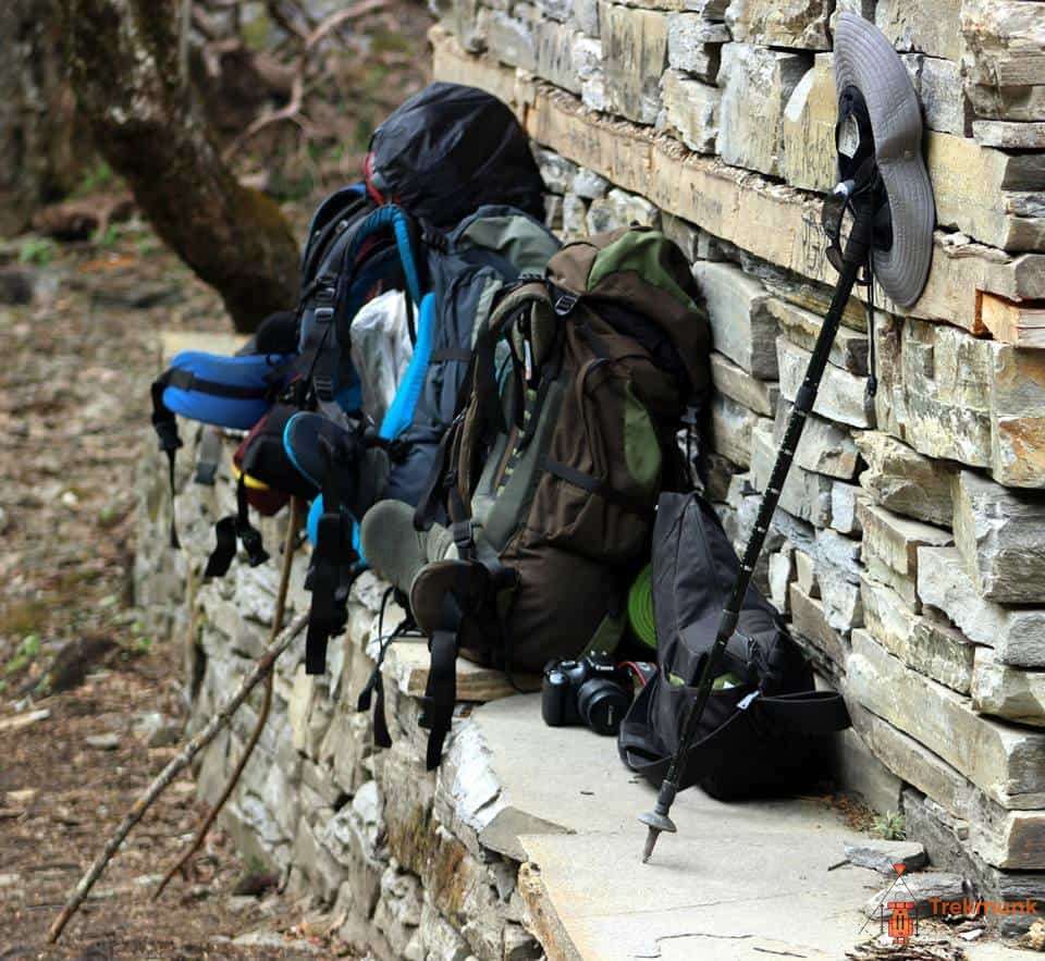
Related Tours
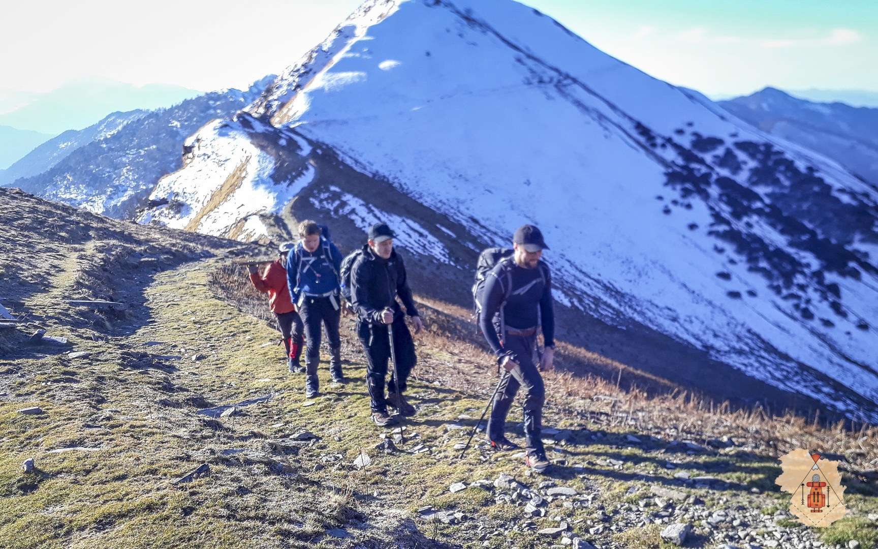
Kuari Pass Trek
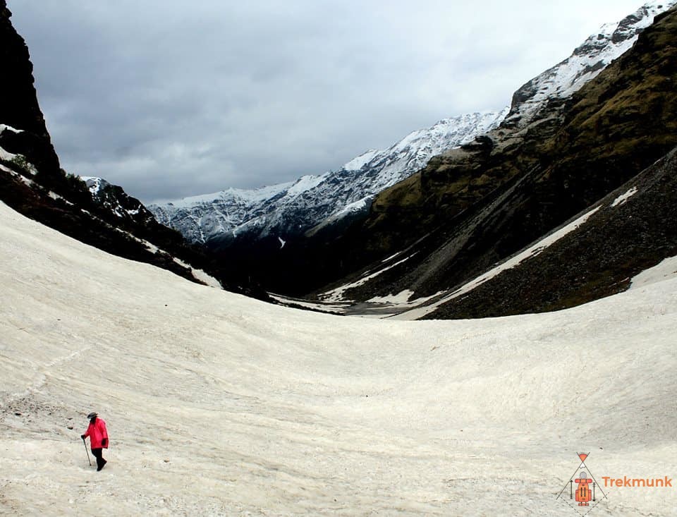
Rupin Pass Trek

"Trekmunk is changing the indian trekking industry"

"10 Most Promising Adventure Sporting and Trekking Companies - 2020"

" Things you do for the Passion for Travel"
Hello there, How can we help you ?
Timing: 10 am to 6 pm IST (GMT +5:30)
Whats App Us
- Dates & Price
- Meaning of Advenchar
- Customer Reviews
- Joshimath to Joshimath
- Dehradun to Dehradun
Proceed Booking
Already a member, don't have an account create one., adding item to wishlist requires an account, why book with us.
- Free Adventure Insurance
- No-hassle best price guarantee
- Customer care available 24/7
- Hand-picked Treks and Expeditions
Got a Question?
Do not hesitate to give us a call. We are an expert team and we are happy to talk to you.
+91 8078656096
")
Pangarchulla Peak Trek
The Pangarchulla Peak Trek is one of the most challenging treks in Uttarakhand, India. Located at an altitude of 15,069 ft, it offers a perfect test of non-technical climbing skills for mountaineering enthusiasts. The trek route takes you through some of the most captivating high mountain views of the Indian Himalayas and culminates with a summit at 4590 m.
The trek begins from Dehradun and takes you to Joshimath. From there, you will ascend to Gulling and then make your way to Lower Khullara. This is where you will get a stunning view of the snow-capped peaks including Nanda Devi, Dronagiri, Kamet, Hathi Parbat, and many more. From here, you will begin your ascent toward the summit point which is situated at a challenging altitude of 15,069 ft.
Along the way, you will also get to witness some breathtaking views of alpine meadows and lush green forests as well as experience the local culture and traditions. You can also enjoy activities like camping under starry night skies or take part in bird-watching sessions while on this trek. The entire journey is filled with adventure and excitement that makes it one of the most sought-after treks in Uttarakhand.
The Pangarchulla Peak Trek is definitely not for beginners as it requires physical fitness as well as mental strength to complete it successfully. However, if you are an experienced trekker looking for a thrilling adventure then this trek should be on top of your list!
Departure & Return Location
Dehradun I.S.B.T ( Google Map )
Departure Time
Price includes.
- Activity: Trekking, Camping, etc
- Accommodation during Trek (Camping)
- Meals during Trek (Veg)
- All season Camping tents on twin sharing basis, Sleeping bags with adequate sub-zero temperature rating, comfortable mattress
- Safety Equipment includes static rescue rope, seat harness, carabiners, pulleys, ice-axe, crampons, slings
- Forest Permits/Camping Charges/Permits, Trek Permit Fee/IMF Permission – up to the amount charged for Indian Nationals.
- Mountaineering course certified Trek Leader with First Aid knowledge
- Experienced Local guide, cook, helpers
- Porters or mules for carrying common luggage
- Exhaustive First Aid kit including portable oxygen cylinder, oximeter
Price Excludes
- Transportation from Dehradun
- Meals during the road journey
- Any expenses of personal nature
- Mules or porter to carry personal luggage. (extra luggage, if any can be left at the base camp with the authorities)
- Cost Escalation due to natural reasons
- Any expense not specified in the inclusion list
What to Expect
- Tough Summit Day The summit day of Pangarchulla Trek will need you to push your limits and trek for 12-15 hours depending on factors like snow, weather and group fitness levels
- Diversity The trail on the Pangarchulla Peak Trek has dense forests, vast meadows and a pure snow landscape. It is rare to find all in one trek
- Breathtaking 360-degree views The Pangarchulla Peak trek offers breathtaking views of the Garhwal range, including Mt. Nanda Devi, Mt. Kamet, and Mt. Trishul. You can also get a glimpse of the majestic Himalayan peaks like Chaukhamba, Neelkanth, Mana Parvat, Hathi Parvat and many more!
- Scenic beauty The Pangarchulla Peak trek takes you through some of the most beautiful landscapes in India with lush green meadows and dense forests on either side of your path. You will also pass by several villages where you can experience local culture and hospitality first hand!
- Camping The Pangarchulla Peak trek gives you an opportunity to camp under starry skies as you make your way up the mountain slopes. This is a great way to relax after a long day’s hike and enjoy nature’s beauty in its full glory!
Pangarchulla Peak Trek Itinerary
Day 1 arrival in joshimath.
Distance: 290 km Time: 12 hours Altitude: 1,875 m (6,150 ft)
The Pangarchulla Peak Trek starts from the town of Joshimath. The drive from Dehradun to Joshimath is a long and tiring 290 Km road journey through winding mountain roads. If you book transport with us, the vehicles will pick you up at Dehradun I.S.B.T at 7 am. You can expect to reach Joshimath by late evening.
The drive from Dehradun to Joshimath is a beautiful journey through the Himalayan mountains. You’ll be able to see some of the most stunning views of the Garhwal region. The road passes through small towns and villages, giving you a glimpse into the local culture and lifestyle.
You’ll also pass by many rivers and streams that flow down from the mountains, providing some much-needed refreshment during your long drive. As you get closer to Joshimath, you’ll be able to see snow-capped peaks in the distance.
The journey will take around 10-12 hours, so it’s best to carry snacks and drinks with you for the ride. We’ll be stopping for breakfast, and lunch on the way.
Once you reach Joshimath, you can check into your guest house. Your trek leader will have a quick briefing session to let you know what to expect over the next few days. After that, it’s time to rest and relax before your journey begins. After that, you can have dinner and rest for the night before starting your Pangarchulla Peak Trek the next day.
Day 2 Joshimath to Dhak & Dhak to Guling
Distance: 4 km Time: 4 hours Altitude: 2,850 m (9,350 ft)
The second day of the Pangarchulla Peak trek is one that is filled with adventure, scenic beauty, and cultural experiences. As soon as you wake up in Joshimath, the excitement for the day ahead kicks in. You have breakfast, pack your bags, and get ready for the drive towards Dhak village.
The journey itself is an experience like no other. The half-hour ride on the mountain roads is filled with picturesque views of the surroundings. As you make your way toward Dhak village, you’ll start to catch a glimpse of Mt. Dronagiri, which is a sight to behold.
Once you reach Dhak village, the trek officially begins. You start by following the uphill trail from the village. Along the way, you’ll come across many small villages such as Karachi and Tugashi. This provides a unique opportunity to observe the lifestyle of the villagers and their way of life in the mountains.
As you continue on the trail, it transforms into a dense forest of oak and birch trees. The natural beauty that surrounds you is awe-inspiring. With each step, you feel further away from the hustle and bustle of city life.
Eventually, you arrive at Guling, where you’ll take a much-needed break and have your lunch. The gradual incline from Dhak village to Guling is a workout, but it’s worth it once you reach Guling. The scenery is breathtaking, and the feeling of accomplishment you experience after reaching the top is hard to match.
After lunch, you set up camp at Guling for the night. The campsite is a peaceful and serene location, shielded from the chaos of the world. As night falls, you’ll be tempted to stay awake to take in the glittering night sky.
In conclusion, the second day of the Pangarchulla Peak trek is a journey that is a perfect blend of adventure, natural beauty, and cultural experiences. Whether you’re a seasoned trekker or a first-timer, this hike has something for everyone.
Day 3 Guling to Lower Khullara
Distance: 5 km Time: 4 hours Altitude: 3,200 m (10,500 ft)
The trail from Guling to Lower Khullara is relatively easy and pleasant compared to the first day. It’s a gradual ascent through a forest, with stunning views of the valley and the mountains. You’ll cross a few streams and waterfalls on the way, which provide scenic spots for photos.
The Lower Khullara campsite is situated at an altitude of about 10,500 ft. It’s a perfect place to catch your breath and acclimatize for the push to the summit. Upon reaching the campsite, you can take a stroll around and soak in the natural beauty of the place. The stunning panoramic views of the snow-capped peaks, the lush green forests, and the tall trees will leave you in awe of nature.
The campsite is equipped with basic amenities such as camping tents, sleeping bags, and a kitchen tent. The camp staff will set up everything for you, including the dining tent. You can relax, enjoy the evening with your fellow trekkers, have snacks, and retire to the camp early for the night.
Remember to hydrate yourself well and eat nutritious food to fuel yourself for the long day ahead. The summit push will be a strenuous and demanding climb, starting at 1 am. It’s essential to have enough stamina and strength for the ascent. Take some time to rest and recuperate your muscles, so your body can be prepared for the challenging climb.
Most trekkers consider the second day an easy day, but the climb to the summit is not for the faint-hearted. The stunning views and experiences of the second day are worth the effort put in. The beauty of nature around you will motivate you to keep going and reach the summit.
Day 4 Lower Khullara to Pangarchulla & Back
Distance: 12 km Time: 14 hours Altitude: 4,590 m (15,059 ft)
The fourth day of the Pangarchulla Peak trek from Lower Khullara to Pangarchulla and back is an experience that will leave you exhausted yet uplifted by the beauty of the Himalayan mountains. The day starts early, with preparations beginning around 1 am in the morning. It’s important to be well-equipped for the climb, as this day will be the hardest and most challenging of the trek.
As we set out, we’ll be welcomed by the cold winds and the snow-covered boulders that we’ll need to negotiate. There’s a sense of adrenaline that rises in you as you climb higher, and the heights begin to impact you. However, this section of the route will need your complete attention and consciousness.
The soft snow covering the boulders makes it extremely challenging for you to negotiate. In peak winters, it is comparatively easier when the boulders are completely covered in snow. As you near the summit, the last section of the climb may require a fixed rope, depending on the snow conditions. It’s vital to keep in mind that everyone’s safety is paramount, and there’s a predetermined turnaround time for the group.
Once you reach the Pangarchulla summit, the view is awe-inspiring, as you’re surrounded by 360-degree views of the majestic Himalayan mountains. It’s a precious moment to be able to experience the beauty and magnificence of nature at its finest. After spending some time at the summit, we’ll start to trek back towards the Lower Khullara campsite on the same route.
The trek back can be equally challenging as your energy levels are lower, and your body has endured a lot. However, there is a sense of achievement that you carry with you as you make your way back to the campsite.
In conclusion, the fourth day of the Pangarchulla Peak trek is an experience that will leave you tired, but the beauty of the Himalayan mountains will uplift your spirits. It’s an adventure that requires you to push yourself beyond your limits, and the sense of accomplishment at the end of it is priceless.
Day 5 Lower Khullara to Joshimath
Distance: 9 km Time: 5 hours Altitude: 1,875 m (6,150 ft)
The fifth day of the Pangarchulla Peak trek marks the end of a magnificent journey that showcased the beauty of the Garhwal Himalayas. As we leave the Lower Khullara campsite, we can’t help but marvel at the stunning landscape and the peaceful environment. The crisp morning air fills our lungs as we have a healthy breakfast before starting our descent toward Joshimath.
The sound of leaves rustling under our boots and the chirping of birds make the trek all the more charming. The mesmerizing view of the majestic peak, Nanda Devi, stands tall in the distance, reminding us how small we are in comparison to the vast beauty of nature. The trek down to Joshimath is relatively easy, but we still take our time to enjoy the views and savor the surroundings.
As we make our way down, we take a break for a sumptuous lunch and then continue our journey. We pass through small villages, where locals are busy with their daily chores, and we see children playing outside their homes. The warmth and hospitality of the people make us feel at home, and we realize how heartening it is to experience the local culture of the place.
Upon reaching Joshimath, we are once again reminded of the beauty of the Garhwal Himalayas. The crisp air, the sight of the snow-capped peaks, and the serene surroundings make us feel at peace. It is a feeling that words cannot describe. We check into our hotel in Joshimath, tired yet satisfied with the journey we’ve completed.
Day 6 Joshimath to Dehradun
Distance: 290 km Time: 12 hours Altitude: 640 m (3,000 ft)
As you bid farewell to the beautiful surroundings of the Pangarchulla Peak trek, you will feel a sense of awe and accomplishment. This trek has given you memories to last a lifetime. The magnificent views of snow-capped mountains, glistening glaciers, and alpine meadows will remain etched in your mind forever.
The long journey from Joshimath to Dehradun will give you time to reflect on your journey and bid goodbye to the friends you’ve made on the trek. The ride passes through winding roads, picturesque landscapes, and scenic vistas that will leave you spellbound. The drive will take around 8-9 hours, so it’s advisable to carry some snacks and water.
As you relive the moments of the trek, you’ll realize how much you’ve grown and learned during the past week. You may have pushed yourself out of your comfort zone, challenged your limits and discovered new strengths, and made lifelong connections. Your experience on the Pangarchulla trek may have also instilled a sense of respect and appreciation for nature.
As you reach Dehradun, you will understand that the journey may have ended, but the memories, friendships, and lessons you’ve gained will remain with you forever. The last day of the Pangarchulla Peak trek acts as a perfect ending to a trip that you will cherish for many years.
Best Time To Visit Pangarchulla
The ideal time for the Pangarchulla Peak Trek is from March-April and October-December. During these times, the weather is pleasant, and the skies are clear, making it easier to trek. Moreover, these months provide a chance to witness different shades of nature. Let’s take a closer look.
March-April
The months of March and April are the spring months in Uttarakhand, providing an excellent opportunity to trek in the region. The snow starts melting in these months, making the trail more accessible but there’s still snow on the boulder section of the Pangarchulla Peak, making it easier to traverse the most difficult section of the trek.
Moreover, during this time, the forests start blooming with diverse flora, creating a beautiful sight for trekkers. One can enjoy the views of rhododendron, oak, and deodar forests in full bloom. Apart from that, the weather during this time of the year is pleasant, and the skies are clear, providing an unobstructed view of the Himalayan mountain range. Overall, March-April is an excellent time to trek the Pangarchulla Peak.
October-December
The months of October to December are the autumn months in the Garhwal region of Uttarakhand. This time of the year is ideal for Pangarchulla Peak Trek because the monsoon is over, and the weather is dry and pleasant. Moreover, during these months, the valleys come alive with different shades of nature. The forests start changing their colors, and you can enjoy the views of yellow, red, and orange leaves scattered all over the ground.
As the winter sets, the snow starts to accumulate on the peak, making it a perfect setting for snow lovers. Moreover, the clear skies provide an unobstructed view of the surrounding peaks and the Himalayan mountain range.
Pangarchulla Peak Trek Map
Peaks visible from pangarchulla peak, pangarchulla peak trek photos.
")
Frequently Asked Questions (FAQs)
How difficult is the pangarchulla peak trek.
The Pangarchulla Peak Trek is a challenging trek that requires a good level of fitness and stamina. The trail is steep and goes through rough terrain with steep ascents and descents. The altitude gain is significant, and you will be trekking above 4,000 meters, so altitude sickness can be a concern.
However, the stunning views of the Himalayas and the sense of accomplishment make it worth the effort. It’s recommended that you have prior trekking experience and be in good physical shape before attempting this trek. As always, it’s important to consult a doctor before embarking on any physical activity.
What are the requirements for participation?
To participate in the Pangarchulla Peak trek, you need to meet certain requirements:
Physical fitness and stamina: The trek is strenuous, and you will be walking for 6-7 hours daily, often on steep and rugged terrain. Prior trekking experience and good physical shape are highly recommended.
Age limit: The minimum age required to participate is 7 years, and anyone over 60 years old will need a doctor’s certificate ensuring they are fit to trek.
Altitude sickness: You will be trekking at high altitudes, so it’s essential to be aware of the symptoms of altitude sickness, such as nausea, shortness of breath, headache, and fatigue. It’s recommended that you consult a doctor before you begin your trek to get advice on how to minimize the risk of altitude sickness.
Equipment: You will need to carry a backpack, trekking pole, and other essential items, so make sure you are prepared and able to carry the weight.
Mental preparedness: Trekking can be challenging, and it’s essential to be mentally prepared to deal with unpredictable weather, physical exhaustion, and rugged terrain.
In conclusion, the Pangarchulla Peak trek requires a good level of fitness, trekking experience, and proper physical and mental preparation.
What kind of food will be available on this trek?
During the Pangarchulla Peak Trek, you will be provided with nutritious and hygienic vegetarian meals with a combination of Indian, asian and western cuisine. Here’s an overview of what you can expect:
Breakfast: You can expect a warm breakfast with options ranging from porridge, bread, poha, upma pancakes, and tea/coffee.
Lunch: Lunch will typically consist of a packed meal, which you can enjoy at a scenic spot on the trail. It usually includes bread, cheese, rice, and rolls. fruits, chocolates, and juice.
Dinner: Dinner will be a hot and nutritious meal, which will include soup, vegetables, rice, dal, chapati, and dessert.
Snacks: Healthy and energizing snacks like cookies, chocolates, and nuts are also provided throughout the day.
It’s important to note that clean drinking water is vital during the trek, and you should carry your water bottle to refill at designated water sources.
If you have any dietary restrictions or preferences, it’s advisable to inform us in advance to accommodate your needs.
What kind of accommodation will I get on Pangarchulla Trek?
During the Pangarchulla Peak Trek, you will stay in campsites every night, which will provide a unique, immersive experience in the surrounding mountains. The campsites are set up at scenic spots with stunning views of the surrounding Himalayan landscape. Here’s what you can expect:
Tents: You will be provided with high-quality trekking tents, which are spacious, waterproof, and designed to protect you from the elements.
Sleeping bags: Advenchar will also provide you with high-altitude sleeping bags to keep you warm and comfortable during the night.
Toilet tents: There will be separate toilet tents set up at each campsite to ensure privacy and hygiene.
Dining tent: A separate dining tent will be set up where you can enjoy your meals and interact with other trekkers.
It’s essential to note that the facilities during the trek are basic, but they provide all the necessary amenities to ensure your comfort and safety. The camping experience offers a unique opportunity to immerse yourself in nature and enjoy the stunning views, so embrace the experience.
Are there any medical facilities available on this trek?
There are no medical facilities available during the Pangarchulla Peak Trek, and you will be trekking in a remote area where basic medical facilities are not available. However, Advenchar will provide you with necessary medical equipment like first-aid kits and emergency oxygen cylinders. It’s also essential to carry your own medications, such as medicines for altitude sickness or any pre-existing medical conditions, along with an extra pair of prescription glasses or contact lenses, if necessary.
It’s highly recommended that you consult a doctor before you embark on the trek to ensure you are fit and healthy enough to undertake the physical exertion involved in trekking at high altitudes. It’s also essential to stay hydrated during the trek and avoid any alcohol or smoking, which can further exacerbate any health concerns.
In the case of any medical emergencies, our team will be available to provide first aid and help you get to a hospital if necessary. We have a highly experienced team of trek leaders and guides, who carry first-aid kits with them at all times.
However, if you have any ongoing medications or pre-existing conditions, it’s important to carry the medications and to communicate the same with the trek leader before starting the trek.
What kind of clothing should I bring for this trek?
The Pangarchulla Peak Trek goes through very harsh terrain and extreme weather conditions, so packing appropriate clothing is essential to stay comfortable and safe. Here’s a list of clothing suggested for this trek:
Base layer clothing: Thermal inners, synthetic T-shirts, fleece jackets, and pants.
Insulation layer clothing: A warm down jacket, fleece/synthetic jacket, and trousers.
Weather protection clothing: Waterproof and windproof jacket, rain pants.
Trekking pants and shorts: Lightweight and breathable trekking pants, quick-dry shorts, and thermal tights.
Accessories: Warm woolen hats, waterproof gloves, balaclava, UV-protected sunglasses, and a cap.
Footwear: Waterproof trekking boots with good ankle support, high-quality trekking socks, and sandals.
Personal items: Essential toiletries, sunscreen, a towel, and a headlamp with extra batteries.
It’s important to note that you will need to carry these items in your backpack, so ensure that your backpack is spacious and comfortable. Layering your clothes will help regulate your body temperature and protect you from the cold. Avoid cotton clothing and stick to synthetic and woolen materials that wick away moisture and keep you warm even when wet.
You can also consider hiring trekking equipment like jackets, backpacks, and trekking shoes which is available with Advenchar.
How to prepare for Pangarchulla Peak Trek?
Preparing for the Pangarchulla Peak Trek will require a combination of physical fitness, mental readiness, and adequate trekking gear.
Here are some tips to help you prepare:
Physical fitness: Pangarchulla Peak Trek is a challenging trek and requires high levels of physical fitness. You should try to engage in regular exercise for several weeks or months before the trek, such as running, cycling, or hiking. Strengthening exercises like squats, lunges, and leg presses will also be beneficial as the trek requires extensive walking uphill. Additionally, take short treks in hilly areas to get your body acclimatized for longer treks.
Mental readiness: Trekking can be mentally demanding, and it’s essential to have a positive attitude, patience, and persistence. Meditation, yoga, or other relaxation techniques can help prepare you physiologically and mentally for the trek.
Proper gear: It’s crucial to have appropriate gear like trekking boots, a sturdy backpack, trekking poles, etc.
Proper nutrition: Ensure a balanced diet and high protein intake to help prepare and recover from the physical stress of the trek.
Pre-Trek Doctor’s Consultation: It’s highly recommended to have a physical check-up and get medical clearance for the trek before departure. In case of any pre-existing medical conditions, seek medical attention and inform us beforehand.
By following these tips, you’ll be well-prepared for the Pangarchulla Peak Trek and can enjoy the stunning views of the Himalayas.
Advenchar Makes You Happy

Level: Difficult
Pangarchulla peak trek, fixed departure:.
Pre Monsoon 2025 Dates:
- 01,08,15,22 & 29 March 2025
- 05,12,19 & 26 April 2025
Send Your Requirement:
Brief description.
Pangarchulla, also known as the Chimney Peak, adorns the Lord Curzon circuit, which is widely considered among the most legendary hiking routes in the Garhwal Himalaya. Mountaineering enthusiasts may test their non-technical climbing abilities on this peak, which stands at an elevation of 4,590 metres. Even though this journey in Uttarakhand is available at any time of the year, the snow that falls during the winter months makes it impassable. If the level of excitement is directly proportional to the degree of difficulty, then the Pangarchulla Peak Trek in the wintertime would be an adventure that courageous people cannot afford to miss out on. Moderate to Difficult The path leading to Pangarchulla and Kauri Pass is unaltered right up to the last day of the hike. You have a clear view of Nanda Devi to your left and the crown of Pangarchulla to your right, both perched above a deep forest that is heavy with pine trees, while you are driving to Dhak, which is the head trail for this spectacular summit.
Delight in the breathtaking views of breathtaking mountains like Mount Nanda Devi, Chaukhamba, Donagiri, Kedarnath, Neelkanth, Haathi-Parbat, Ghori Parbat, and many more. The Pangarchulla trek takes you through various landscapes relatively short, exposing you to a wide range of environments along the way. These environments include local towns, dust trails that lead to vast open meadows, dense forests, pristine streams, and rocky patches that lead into the white of the snow.
Highlights and Key Features
Technical detail, participant eligibility and health requirements for the trek:.
Age Limit: Participants from 15 years and above are welcome to join the Trek.
Experience Level: Previous trekking experience is mandatory.
Physical Fitness: Participants should be capable of carrying a 15 kg Rucksack (backpack). Fitness is crucial, and climbers must possess sufficient stamina to cover a distance of 5 km in 30 minutes without experiencing undue stress.
Health Requirements: – Resting pulse rate: 60 to 90 beats per minute – Blood Pressure: Diastolic 75 – 85 mm Hg, Systolic 100 – 130 mm Hg – Resting respiratory rate: 12 to 20 breaths per minute – No history of liver and kidney issues – Absence of Diabetes Mellitus, Bronchial Asthma, Epilepsy, Heart problems, Hypertension, etc. – No existing health issues that might adversely impact the participant during the trek – BMI under 25 (Exceptions for individuals with heavy bone density and those regularly engaged in weightlifting exercises)
Pre-Existing Conditions: Participants with any pre-existing medical conditions or those currently on medication must declare it in the Self Declaration form.
Special Casual Leave for Government Employees: Parvat Exploration, a registered adventure tour operator, allows government employees to avail of Special Casual Leave (SCL) for up to 30 days in a calendar year, as per the rules of the Pay Commission. This benefit applies when participating in trekking or mountaineering expeditions organized by a registered adventure organization like Parvat Exploration.
Special Note for Junior Trekkers: For participants below 15 years, a parent or guardian must accompany them. Trekkers aged 15 to 18 can participate solo but must provide a signed disclaimer form from a parent or guardian.
Parvat Exploration ensures that participants meet the necessary health and fitness criteria, promoting a safe and enjoyable trekking experience in the breathtaking landscapes of the Uttarakhand Himalayas
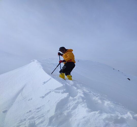
Day 1: Rishikesh to Karchi Village (2286 M) via Joshimath (1890 M)
Distance: 275 kms
Duration: 10 hours ( Drive)
Begin your journey from the spiritual town of Rishikesh, embarking on a picturesque drive towards Karchi Village, Base foe Kuari Pass Trek passing through the charming town of Joshimath. The route offers stunning views of the Himalayan landscapes and introduces you to the rich cultural tapestry of the region. Arrive at Karchi Village, a quaint Himalayan hamlet, and settle in for the night.
Day 2: Karchi Village (2286 M) to Gulling Campsite (2870 M)
Distance: 05 kms
Duration: 04 hours trek
Begin the trek from Karchi Village, heading towards the Gulling Campsite. The trail takes you through dense forests, meandering streams, and quaint Himalayan villages. Gulling Campsite, nestled amidst nature’s embrace, provides a serene setting for a night under the star-lit sky.
Day 3: Gulling Campsite to Khullara Campsite (3390M)
Distance: 5 kms
Durations: 3 hours
Continue your ascent as the trail leads you to the Khullara Campsite. This leg of the journey unveils breathtaking vistas of the surrounding mountains and lush meadows. Khullara Campsite offers a picturesque spot to rest and rejuvenate in preparation for the next day’s adventure.
Day 4: Khullara (3,390m) to Pangarchulla (4,590m) and Back to Khullara (3,390m)
Distance: 14 kms
Duration: 12-16 hours
Embark on an exhilarating ascent from the tranquil Khullara Campsite to the lofty summit of Pangarchulla, standing proudly at 4,590 meters. The trail unfolds through rugged terrain, challenging your perseverance with steep climbs and rocky paths. As you ascend, witness the landscape transform, offering breathtaking views of the surrounding peaks and valleys.
Reaching Pangarchulla’s summit, be rewarded with an awe-inspiring 360-degree panorama, showcasing the grandeur of the Himalayan range. The iconic peaks of Nanda Devi, Dronagiri, and Chaukhamba create a majestic backdrop against the clear sky. Take a moment to absorb the sheer magnificence of your surroundings.
After relishing the summit experience, commence your descent back to the comforting embrace of Khullara Campsite. The journey down allows for reflection on the achievement of conquering Pangarchulla and offers a chance to appreciate the diverse ecosystems encountered during this high-altitude adventure. As night falls, find solace and warmth at Khullara, nestled amid the Himalayan wilderness.
Day 5: Khullara(3390 M) to Karchi Village (2286 M)
Distance: 10 kms
Duration: 4 hours
Bid farewell to the Khullara Campsite and begin your descent towards Karchi Village. The journey back allows you to reflect on the experiences of the trek, surrounded by the beauty of the Himalayas. Reconnect with the village atmosphere as you reach Karchi and spend your last night in the serene Himalayan setting.
Day 6: Departure from Karchi Village (2286 M) to Rishikesh
Conclude your Parvat exploration with a journey from Karchi Village back to Rishikesh. Cherish the memories of the Kuari Pass trek, carrying with you the breathtaking views, cultural encounters, and a sense of accomplishment from this Himalayan adventure. Depart with a heart full of experiences and a spirit rejuvenated by the wonders of nature.
Inclusion & Exclusion
- Accommodation in Homestay on day 1& 5 and in camps on day 2,3&4 on triple sharing basis
- Forest permits/camping charges
- Delicious & nutritious vegetarian food ( meals : breakfast, lunch, snacks & dinner)
- Day 1 dinner to day 6 breakfast
- Camping equipment (sleeping bag, mattress, 4 season tents,toilet tent& dining tent)
- Trek guide, cook, helpers, porters & Services of a Certified Trek Leader (BMC or AMC Qualified)
- Transportation from Rishikesh to Karchi Village and back to Rishikesh.
- Technical equipment like Gaitors & spikes
- Safety Equiptments: Basic First Aid, Oxygen Cylinder, Ropes
- Meals during road journeys
- Permit for Foreign Nationals
- Carriage of Personal Bags during the trek
- Any kind of Insurance
- Any expense of a personal nature
- Rental of Personal Equipment
- Any expense not specified in the inclusion list.
- Any evacuation cost or Medical treatment cost
- Any extra costs incurred caused in the event of finishing the expedition early.
- Tips for local guides or porter
- Any cost arising out of unforeseen circumstances such as bad weather, landslides, road conditions and any other circumstances beyond our control.
Things to Carry
Essential Trekking Gear:
1. Rucksack bag with rain cover – Qty: 1 2. Day pack bag (recommended for treks with summit day) 3. Head torch with spare batteries – Qty: 1 4. UV protection sunglasses – Qty: 1 5. Water bottles: 2 bottles of 1 liter each
Footwear: 6. Non-skid, deep-treaded, high-ankle trekking shoes – Qty: 1 7. Pair of lightweight slipper/sandals – Qty: 1
8. Quick-dry warm lower or track pants – Qty: 2 9. Full sleeves T-shirts/sweatshirts – 1 for every 2 days of trekking 10. Pair of thick woolen socks – 1 pair for every two days of trekking 11. Thermal body warmer upper & lower – Qty: 1 12. Undergarments – Qty: 1 for every day of trekking 13. Warm jacket closed at wrist & neck – Qty: 1 14. Full sleeves sweater – Qty: 1 15. Rainwear (jacket & pants) – Qty: 1 16. Pair of waterproof, warm gloves – Qty: 1 17. Woolen cap – Qty: 1 18. Sunshielding hat – Qty: 1
Toiletries: 19. Personal toiletries kit (small towel, toilet paper, paper soap, bar soap, toothbrush, toothpaste, cold cream, etc.) 20. Sunscreen lotion small pack – Qty: 1 21. Lip balm small pack – Qty: 1
Utensils: 22. Small size, lightweight & leak-proof lunch box – Qty: 1 23. Plate – Qty: 1 24. Spoon – Qty: 1 25. Tea/coffee (plastic) mug – Qty: 1
Miscellaneous: 26. Camera (optional) 27. Carry your medicines in plenty in case you have any specific ailment. Consult your doctor before joining the trek. 28. Dry fruits, nuts, chocolate bars (optional) Note: This comprehensive list covers essential items for a trek with Parvat Exploration. Adjustments can be made based on specific trek requirements and personal preferences. Participants are advised to double-check with Parvat Exploration for any trek-specific recommendations or variations in the list.
Parvat Exploration: Your Trusted Himalayan Guides
Embark on an unforgettable adventure with Parvat Exploration – where expertise meets passion. Here’s why choosing us for your trek is the key to an extraordinary Himalayan experience:
1. Highly Qualified Team, Seasoned in Indian Mountaineering : Join a team of seasoned mountaineers with a wealth of experience navigating the challenging terrains of the Indian Himalayas. Our expertise is your assurance of a trek that combines adventure with safety and knowledge. 2. Exclusive IMF Associate Membership: Trust your journey with the best, as three of our team members hold an esteemed position as associate members with the Indian Mountaineering Foundation (IMF). This exclusive membership is limited to only 100 individuals in India, highlighting the caliber and dedication of our team. 3. Local Expertise – Meet Team Parvat Exploration, a Himalayan Native : A proud local born and raised in Uttarakhand. The Himalayas are not just our workplace; they are our home. With Team Parvat Exploration as your guide, you’ll experience the mountains through the eyes of someone deeply connected to its culture, people, and nuances. 4. Accredited by ATOAI, IMF & Uttarakhand Tourism: Parvat Exploration proudly stands as an affiliated firm with the Adventure Tour Operators Association of India (ATOAI), the Indian Mountaineering Foundation (IMF), and Uttarakhand Tourism. Our triple accreditation underscores our commitment to responsible and high-quality trekking adventures. 5. Safety is Our Pledge: Your safety is our topmost priority. At Parvat Exploration, safety isn’t just a priority; it’s a fundamental principle that guides every aspect of our treks. Rest assured, you’re in capable hands as we navigate the trails with your well-being as our foremost concern. 6. World-Class Equipment: Equip yourself with the best, as we provide world-class gear. Our equipment is meticulously maintained and regularly updated to meet the highest industry standards, ensuring your comfort and safety throughout the trek. 7. Delicious and Nutritious Food with Local Delicacies: Savor the journey with our culinary delights. Our team takes pride in offering not just nourishing meals but also a variety of options, including delicious and nutritious local dishes. Immerse yourself in the rich flavors of the region as you trek through the breathtaking landscapes. 8. Expert Trek Leaders – AMC Qualified: Our trek leaders are not just leaders; they are minimum AMC qualified from recognized institutes. This ensures that you are guided by professionals who understand the nuances of mountain terrain and are well-prepared for any challenges that may arise. 9. Seasonal Specialization – All Year Adventure: Parvat Exploration specializes in mountaineering during the prime season and offers captivating winter treks. Whether you’re drawn to the thrill of summer ascents or the serene beauty of winter landscapes, we have the expertise to make your trek extraordinary, regardless of the season. Choose Parvat Exploration for a trek that transcends the ordinary. Your Himalayan adventure awaits, crafted with expertise, passion, and a commitment to making your journey truly exceptional.
Subscribe to our newsletter
Registered address.
150 Harbajwala, Dehradun, Uttarakhand: 248171
Garhwal Head Office
228 Ward No 05, Barkot, Uttarkashi, Uttarakhand: 249141
Kumaon Head Office
Matena, Near KMVN, Almora, Uttarakhand: 263601
- Privacy Policy
- Terms & Conditions
- Environmental Policy
- Cancellation Policy
Parvat Exploration
05ABCFP5491P1ZN
UTDB Cert. No.:
UTTR/ALMORA/13-2023/006463
+91 72176 50905
+91 94561 12947, +91 95281 25747, [email protected], affiliations.
Copyright © 2023 Parvat Exploration. All rights reserved.
Website Developed by Veb Design Solutions
Start typing and press enter to search

Pangarchulla Trek – Summit a 15,000 ft Himalayan Peak
Region: Uttarakhand
Base Camp: Joshimath
Grade: Moderate
Distance: 52 Km
Min Age: 15 Years
Best Season: Spring, Summer and Autumn
Trek Description
Pangarchulla Peak is located in the Chamoli District of Uttarakhand at an altitude of 15,009 ft/4,572 m . The trail for this trek goes through the “ Kuari Pass ” or Lord Curzon Trail , giving you the double treat in one trek with Kuari Pass and Kuari Top both covered.
George Curzon , then viceroy of India (1899-1905), visited this place and, hence the name. This trail is also part of “Chimney Peak” (14,700 ft). The name “Kuari” has other cultural significance, as it is known as the Abode of Goddess Nanda Devi.
The trek perfectly blends rugged terrain, high altitude, summit climb, and snow-covered trail, yet it is beginner-friendly with some prior trekking experience.
From Pangarchulla trek, you get panoramic views of various peaks like Mt.Nanda Devi, Dronagiri, and Mt. Trishul. The trail is filled with dense forests of Walnuts, Birch and other trees.
The final summit trek is filled with snow, boulders and steep ascent, quenching your thirst for an adventure without a difficult or technical climb. This factor makes this trek more favorable than the Kedarkantha Peak trek .
Drive Distance : 250 Km
Drive Time : 9-10 hours
Altitude : 6,150 feet (approx)
The distance from Rishikesh to Joshimath is 250 km, which takes 9-10 hours to complete via NH7. We will leave Rishikesh early in the morning, enjoying the beautiful road journey.
On our way, we will come across 4 out of 5 Panch Prayags (Prayag is a holy confluence of two rivers). First, we will come across Devprayag (the last Prayag), where Alaknanda meets Bhagirathi to form the river Ganga finally. Then, we will encounter Rudraprayag (4 th ), where Alaknanda meets the Mandakini River. At Karnaprayag (3 rd ), Alaknanda meets the Pindar river. Lastly, at Nandprayag (2 nd ), Alaknanda meets the Nandakini river.
These rivers will follow you along till Joshimath, adding more beauty to your road trip.
We will spend the night in Joshimath to get refreshed for another drive and hike the next day. Tip – It is advised that trekkers reach Rishikesh on Day 0, which is a day prior, to avoid delays. By reaching on Day 0, you can take a short tour of Rishikesh.
Trek Distance : 5 Km
Trek Duration : 3-4 hours
Altitude : 9,600 ft
Dhak village is 11.1 drive away from Joshimath, which takes approx 45 mins to cover.
After this short drive to Dhak village, our trek starts towards Gulling Top via Tugasi village, our first campsite.
The trail towards Gulling is filled with trees of oaks, maple, pine, and walnuts, giving you a chance to enjoy fresh nuts right off the tree. The gulling top is a vast open field providing beautiful views of various snow-covered mountain peaks like Mt. Dronagiri.
After our hike for the day, we will stretch and enjoy a delicious hot dinner.
Trek Distance : 7 Km
Trek Time : 5-6 hours
Altitude : 11,000 ft
After a delicious breakfast, we will head for Khullara Top. The ascent climb is a little bit steep but not tiring. The whole trail will go through the deep forest of Oak, Thunder, and Cedars. Throughout the hike, Mt. Dronagiri will follow you along other peaks. You will find small clear water streams here for drinking water.
Khulara Top provides a grand space for camping, like a small bugyal, with the Himalayan Peaks like a big tapestry hanging in the background.
Trek Distance: 14 Km
Trek Time : 7-8 hours
Altitude : 12,500 ft
The trek today will be long but worth every step. After a steep climb of 1.5 km, you’ll walk on a ridge famously known as “Lord Curzon Trail” . Our trek will continue on this ridge and inclines, finally leading to Kuari Top. From here, you can clearly see many peaks like Dronagiri, Hathi Parvat, Chaukhamba, Neekanth, and so on.
After a short descent from the top and a few kms, you’ll reach Kuari Pass. The trail remains the same for both Kuari Top and Kuari Pass, as both are at the same altitude.
We will retrace back to our campsite – khulara, and rest well for the next day’s summit climb.
Trek Time : 10-12 hours
Altitude : 15,000 ft
The most awaited part of the trek begins today – the summit climb to Pangarchulla Peak.
We will begin our trek at midnight, 1:00 am, yes, to catch the first rays of the sun sparkling on the snow-covered mountain peaks.
After packing our food, we will start our trek carefully, as it will be dark and difficult to walk on a snowy path. The path is a mixture of knee-to-waist-high snow, boulders, and ridge walking, making it adventurous and difficult to trek. Today, we will gain more altitude and walk for a longer period of 10-12 hours on difficult terrain.
It is advised to be prepared with the right gear and follow the trek leader’s expert advice to avoid mishaps.
After reaching the Pangarchulla Peak, you can locate many peaks like Nanda Devi (7816 m), Kamet (7756 m), Hathi Parbat (6727 m), Gauri or Ghori Parbat (6708 m), Neelkantha (6500 m), Mana (7274 m), Deoban (6855 m), Trishul (7120 m), Trishul II (6690 m), Trishul III (6007 m) and Dronagiri (7066 m).
Trek Distance: 12 Km
After taking a well-deserved rest, we will start our descent back to Joshimath via the same route, enjoying everything all over again. It will take us around 5-6 hours to reach back. From Dhak or Tugasi we will take a taxi back to Joshimath. It will be 1 hour drive only.
Upon reaching back, you are free to take a stroll through the town or rest and relax your muscles
Drive Distance: 250 Km
After breakfast, we will bid bye to Joshimath with a promise to return soon for another trek.
What’s Included and Excluded?
Price inclusion.
- 2 Nights stay in Joshimath
- 4 Nights camping
- Meals from Day 1 dinner to Day 7 breakfast
- All the required forest and camping permits
- Sleeping bags, Mattresses and Tent
- Helmet, Ecobag and First aid kit with oxygen cylinder
- Certified Trek Leader
- Trek completion certificate
- Transportation from Rishikesh to Rishikesh
Price Exclusion
- Trek Insurance
- Meals during the transfer
- 5% GST is not included
- Any expenses not mentioned in the inclusion
- For backpack offloading additional fee will be charged
- Any expenses arising from emergencies during the trek
- Any personal expenses
What to Bring Along
- 45-60 Ltr Bag Pack With Rain Cover & Comfortable Straps
- Hot & Cold Water Bottle Like Borosil & Milton
- Energy Bar, Dry Fruits & ORS
- Personal Medical Kit
- 2/3 Full Sleeves (Non-Cotton)
- 1 Full Fleece T-Shirt
- 1 Fleece Jacket (Woollen Or Sweater)
- 1 Down Feather/Hollofil Jacket
- 1 Waterproof Jacket/Poncho
- 1 Pair Thermal Inners (Upper And Lower)
- 2 Trek Pants (Avoid Shorts & Denim Pants)
- 1 Pair of Waterproof Gloves
- 1 Pair of Woollen Gloves
- Woollen Cap
- 4 Pairs Of Cotton Socks
- 1 Pair Of Woollen Socks
- 1 Pairs Of Sunglasses (U/V Protected)
- 1 Neck Gaiters (Buff)
- 1 Waterproof & High Ankle Trekking Shoes
- 1 Pair Of Floaters
- Hand Sanitizer & Sunscreen Lotion
- Toothbrush And Toothpaste
- Toilet Paper And Wet Wipes
- Quick Dry Towel
- Lip Balm & Antibacterial Powder
- Moisturizer
Ways to Reach
The nearest airport is Dehradun’s Jolly Grant Airport, which is just 15.8 km away from Rishikesh.
From here, you have two options.
- From the airport, the main city of Dehradun is 1.5 km away; walk till there or hail a shared auto/taxi.
- Hire a private taxi or shared one if it is convenient for you to direct Rishikesh itself.
You can book a direct train to Rishikesh railway station, which is named Yog Nagri Rishikesh Station, Rishikesh being the Yoga Capital of the world.
Option 2 is to book train tickets to Dehradun, which is 38.4 km away with 1-hour drive time.
Similarly, you can book tickets for Haridwar, which is 44 km away and has a 1-1.5 hour drive time. Tip – Book for a train that reaches Rishikesh early in the morning on Day 0. It will give you time to acclimatise to the weather, and a short tour of the city can also be done.
Joshimath is well connected to motorable roads, so you can directly drive here in your private vehicle.
Another option is to reach Delhi, the capital of the country. The city is well-connected with all parts of the country. From Delhi, you can book a bus ticket directly from the Kashmiri Gate bus stop or use online booking platforms like Redbus.
Local buses from various operators like UTC, Vishwanath Seva, and Himgiri are available from Rishikesh or Dehradun to Joshimath. These buses leave early in the morning from Rishikesh Domestic Bus Stand and Parade Ground, Dehradun.
Raithal is the point where we start our Dayara Bugyal Trek in Uttarakhand. It is approximately 183 kilometers away from Dehradun, which takes around 6 to 7 hours by public transportation. To reach Raithal you have to reach Uttarkashi first.
The bus to Uttarkashi leaves early in the morning around 5:30 am from Dehradun Hill station. You can also book your ticket online via the UTC portal. The average cost of the ticket is around 350 to 400 INR. Shared taxi option is also available.
If you are traveling via taxi, you will be charged around 400 to 500. You can hire a taxi from Rispana Pul and Parade Ground to Uttarkashi. Upon reaching Uttarkashi, you can rent another taxi to Raithal from Uttarkashi Taxi Stand. You must pay 100 to 150 INR to hire the taxi.
Difficulty Grade of Pangarchulla
The Pangarchulla Trek is rated as moderate to difficult level. A trek’s difficulty is decided on the basis of the number of days required, terrain & gradient type, and altitude gain.
- Altitude Gain – The Pangarchulla peak is at an altitude of 15,069 ft above sea level. As a high-altitude trek, the threat of health issues like AMS ( Acute Mountain Sickness ) increases, leading to worse problems like HAPE/HACE.
- Long Trek – There are many long treks, but here you have to walk more on a single day, and changing weather, such as increasing altitude, takes a toll on the body if not acclimatised well.
- Changing Terrain – The starting is easy, but the mixture of terrain and different gradients to the summit top makes being physically and mentally fit essential. Factors like rough winds, big boulders, steep summit climbs, sharp ridges and walking ina knee to waist-deep snow add more challenges and thrill to the trek.
Hence, it is advised to follow a proper workout routine that includes both strength training and cardio. Try to achieve running 5 kms in 45 mins. This will make your trekking experience more pleasant without any problems.
Prior experience with treks and snow treks like Kedarkantha, Dayara Bugyal , Sandakhphu, or Rupin Pass will help you better prepare for this trek.
Ideal Time to do Pangarchulla
Pangarchulla is famous as a winter trek but it can be done during other seasons and making each experience unique.
Months – November to February
Temperature – Day: 5℃ to 10℃ | Night: -5℃ or below
The best time to experience a snow-covered adventure. During these months, you’ll find thick snow sheets with chilly winds and freezing temperatures waiting for you. Though you’ll find snow on summit climbs throughout the year during winters, the feel is different.
For adventure enthusiasts, winter is the perfect season as the snow becomes hard, making the challenging, and heavy snowfalls closing down paths and forcing you to trek in deep snow adds more challenges.
Tip – Rent proper gear like crampons, headlamps, water-repellent shoes, gaiters and appropriate clothing.
Months – April to June
Temperature – Day: 10℃ to 12℃ | Night: -2℃ to 5℃
In spring, the snow starts to melt as the increasing temperature makes snow soft and easy to walk. Trek during this time still remains challenging enough for adventure seekers without the freezing temperatures.
After harsh winters, springs bring back the colour in the region. With melting snow, life returns with the excitement of a new beginning. Beaming colourful flowers, vibrant meadows, and forest greenery with a white backdrop of the Himalayas create a beautiful live image.
Culture, Flora Fauna and Adventures
Mythology of dronagiri parvat .
According to Ramayana, when Lord Ram’s younger brother was severely injured during the battle with Demon King Ravan’s son Meghnad, a rare herb “Sanjeevni” was the only cure.
Hanumanji was tasked with fetching Sanjeevni, which can only be found in the Himalayas.
It was believed that Sanjeeevni was found on Mt. Dronagiri/Dunagiri or Gandhamardhan. But Hanuman could not identify the herb, so he took the whole mountain to the battlefield.
After this incident, the locals stopped worshipping Lord Hanuman. This ritual is still followed in present times. Even during the Ram-Leela performance in the festival of Dussehra, the Hanumanji part is skipped entirely.
Nanda Devi Raj Jaat Yatra Festival
Nanda Devi is believed to be Goddess Parvati, so when she married Lord Shiva, she moved to Kailash Parvat, leaving behind her maternal place.
This three-week-long festival is organized once every 12 years, which signifies that Maa Nanda Devi visits her hometown every 12 years. Other than 12 years Raaj Jaat, there is Lok Jaat which is celebrated every year. The festival is celebrated with enthusiasm in nearby villgages of Joshimath and Chamoli.
Uttarakhand is blessed with diverse flora and fauna. You can spot animals like Himalayan Brown bears, Langurs, Himalayan Musk Deers and, during winters, even a Snow leopard.
During the trek, you will come across a diverse range of trees and flowers, such as Silver Birch, Oak, and Pine. Pink and White flower Rhododendrons, also known as “Buransh ke Phool ”, welcome you when in bloom.
The magical properties of Thuner’s tea will vanish your cough & cold in minutes.
If luck is in your favour, you may spot birds like the Himalayan Monal (State bird of Uttarakhand) and Himalayan Griffon Vulture.
Badrinath Temple- One of the pilgrims in Char-Dham Yatra, Badrinath temple is just 40.5 km away from Joshimath. Situated at an elevation of 10,171 ft, the trek to the temple is filled with devotion, joy and beautiful views of the Himalayas.
Joshimath – Our base village of Trek provides many sites and temples, like Narsingh Devta temple, Adi Shankaracharya Math, Auli Ropeway, Jogidhara Waterfalls etc, for you to explore.
Valley of Flowers – Recognised as the prestigious UNESCO World Heritage Site in 2002, this valley is home to more than 600 species of flowers. One of India’s oldest treks, accidentally found in 1931, is a must-visit.
Bagini Glacier Trek – Enjoy a trek to the glacier without crowd and hassle, just an hour’s drive away from Joshimath to Jumma base village. Peaks like Changa Banga and Kalanka add to the beauty of this glacier.
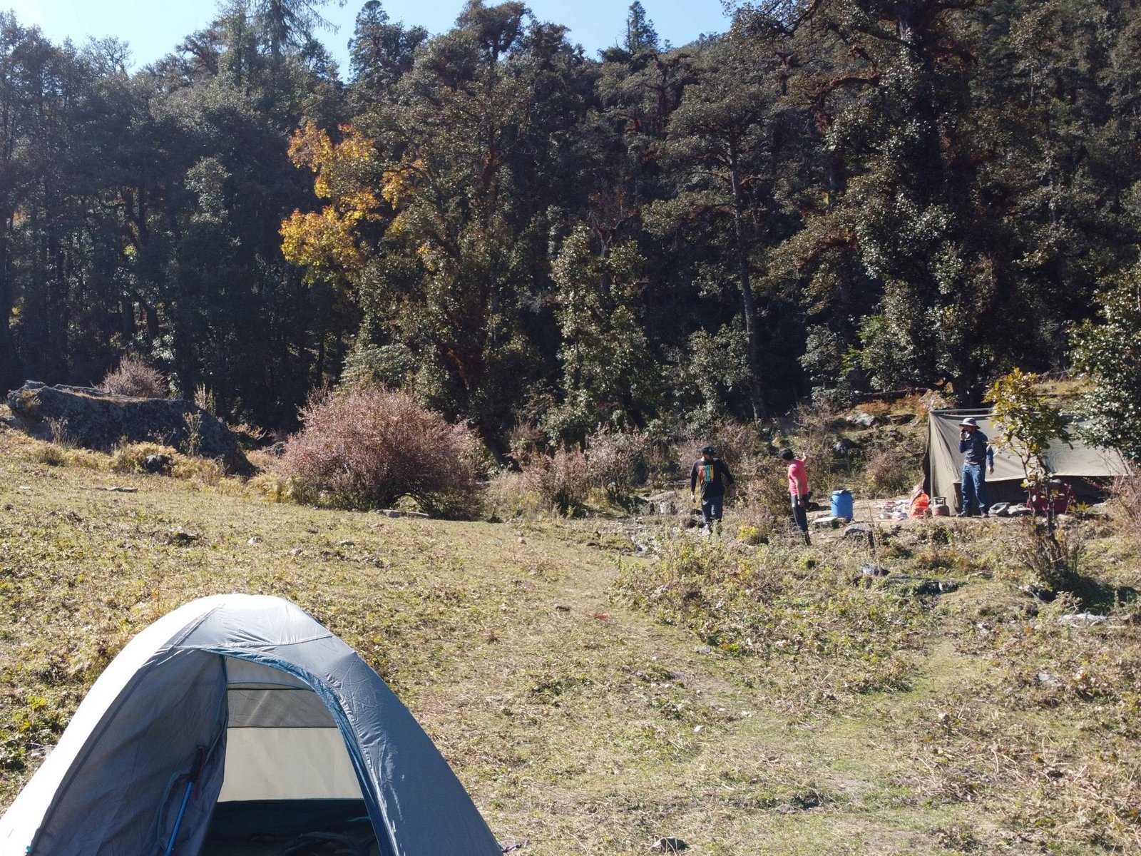
Map of Trail
The total trek on foot distance is 52 km.
Yes, a permit is required as Pangarchulla lies in a protected area. If you hire a trekking company like ours, then it is covered in the package itself.
Yes, gears like spikes, gaiters, trekking poles, etc, are a must. You can buy or opt to rent gear.
Yes, as it is a moderate-level trek, prior experience helps you understand and adjust better to higher altitudes, snow and ever-changing weather conditions.
Charging your gadgets might be always challenging during the trek. During this trek, the last charging point you will get is at Joshimath. So it is recommended to carry spare batteries for cameras and a power bank with a capacity of more than 20,000 mAh to ensure you have enough power for the entire trek.
In Joshimath, network is available via networks like Jio, Airtel and BSNL.
Aadhaar card, Declaration form, and Trek Insurance . If you are a teen then a parent’s declaration will be needed. If you are 60+ then a medical certificate will be required. And if you are a foreign national then your Passport will be needed for issuing permits.
/ Per Person
Cancellation Policy
Available Dates
Contact us for booking
Contact us for Booking
Similar Treks

Kuari Pass Trek

Gaumukg Tapovan

Kedar Tal Trek

Nandanvan Vasuki Tal Trek
Leave a comment cancel reply.
Email me when someone replies to my comment
Save my name, email, and website in this browser for the next time I comment.
Terms & Conditions
Subscribe to our newsletter
Get news and discounts straight to your inbox
We are Associated With

Himalayan Dream Treks
We believe in making the Himalayas more than just a destination; we see them as a life changing experience. Whether you seek spiritual enlightenment, have a passion for trekking, or simply crave adventure, we're here to accompany you on your journey.
Important Links
Why Choose Us?
Advance Payment
Cancellation Policy & Refund
Privacy Policy
Terms & Condition
Career At HDT
Contact Details
+91-80896 93825
+91-94565 46051
Join Our WhatsApp Group
Office Address
Dehradun Office :
10 B, Mothorowala Rd, Dharampur, Ajabpur Kalan, Dehradun, India, Uttarakhand, 248121
© All Rights Reserved 2024 Himalayan Dream Treks
(To the Himalayas and Beyond) — Designed & Developed by DeveloSquad
Home » Shop » Pangarchulla peak with Kuari Pass trek
- getting there
- Detailed Itinerary
- cost inclusions
- cancellations
- 1 Week trek
- Garhwal Treks
- Moderate Grade Treks in Himalayas
- Spring Treks
- Summer Treks
- Uttarakhand
- Winter Treks
Pangarchulla peak trek with Kuari Pass:
- Upcoming group fixed departure to Pangarchulla peak will be published soon for autumn/winters 2023.
- Private/customised treks for your own group/family is open as per your preferred date. TREK FEE will be same for a group of 8 to 10 persons i.e. ₹ 12500 + 5% GST per person (Joshimath to Joshimath) and will be proportianately lower for 11 persons or more in a private/customised tour.
Pangarchulla trek route offers you one of the most captivating high mountain views of Indian Himalayas along with a satisfaction of climbing to a summit at ~ 15000 ft. The peak stands tall in the vicinity and present unmatched Panorama of central Garhwal peaks at a stretch of 180°. You can spot Nanda Devi clearly to your north east to all major peaks of Badrinath valley and finally stretching to Kedarnath valley peaks on west. Nanda Devi, Dronagiri, Changabang, Rishi, Mukut, Kamet, Abi Gamin, Mana, Hathi, Ghoda, Neelkanth and Chaukhamba massif to name a few!

Starting from October weather becomes clear and you can view mesmerising vista throughout the trek.

Exquisite campsites add more charm and delight. You will camp inside deep conifer forest, on the fringe of the jungle and alpine meadows, locally called Bugyal. Note that at present we can’t camp on alpine meadows.

This is not all! Once the tree line ends, landscape switch into fur flung meadows. From Khullara to Kuari pass, you will walk on these grassy slopes. Towards the end of the trek, you will cross Gurson Bugyal, a prominent meadows of the Himalayas.

Brief Itinerary:
Day 1: Drive from Rishikesh to Joshimath – 10/11 hours – 250 Km. Lodge. Day 2: Drive to Karchi village (7500 ft) via Dhak – 15 Km, 45 minutes. Then trek to Khullara (11,1000 ft) – 11 Km, 6/7 hours. Camp. Day 3: Visit Kuari Pass (12630 ft) and return to Khullara – 8 Km- 6/7 hours. Camp. Day 4: Khullara (11,100 ft) to Pangarchulla summit (14,925 ft), 6 hours and back to Khullara – total 12 Km – 12/14 hours . A strenuous and challenging summit day. Camp Day 5: Khullara (11,100 ft) to Auli (8600 ft) via Gurson Bugyal, 5/6 hours – 10 Km – drive to Joshimath 45 mins/14 Km. Lodge. Day 6: Drive from Joshimath to Haridwar – 280 Km – 11/12 hours.
Important Notes on itinerary:
- Our 6 days itinerary includes both Pangarchulla peak climb and visiting the actual Kuari pass . However it depends on the performance of the team, in addition to snow and weather conditions. Understand that Pangarchulla summit is a possibility when you are highly fit and well acclimatised on the mountain and weather is with you.
- From Oct 2018, due to an order from Uttarakhand High Court, one is NOT allowed to camp on alpine meadows/grasslands, locally called “Bugyal”. In this trek our high camp will be either at Gulling and Lower Khullara. We will visit Kuari Pass and attempt Pangarchulla in two successive days.
- Often it is convenient to reach Rishikesh anytime on Day 0 . Either you can fly to Dehradun (DED, Jolly Grant airport) which is only 1 hour drive from Rishikesh. or you can get Volvo bus services (morning and overnight) from ISBT Kashmiri Gate Delhi to Rishikesh (5/6 hours). Arrange your stay in Rishikesh accordingly.
- Trekkers need to reach Haridwar on Day 1 morning by 6 am latest or the night before. Similarly book your return tickets from Rishikesh/Haridwar on Day 6 evening, 7/8 pm in the evening or later.
Altitude and distance profile graph for Pangarchulla peak trek:
Check the below pictorial representation for Pangarchulla trek route tog get an idea of the climb.

Note: After the camping restrictions imposed from 2018 post monsoon, we can camp up to Khulara area . From here Pangarchulla summit is quite a climb. A reasonably fit person should take anything between 12 to 16 hours for a summit push and return in favourable conditions.
Is Pangarchulla trek possible during winters?
As they say nothing is impossible, but indeed difficult and strenuous. Let us understand this properly:
Pangarchulla summit gets a double whammy during winters due to:
1) Fresh snow
Being north of Kuari Pass and close to the high mountains, this region normally receives early snowfall. This can be as early as the beginning of November. From December usually snow fall will be more frequent and deposited snow will make it strenuous. Furthermore, Pangarchulla peak summit is at ~4550 m/14925 ft, which is high altitude even in Himalayan standards. In winters expect knee deep or even more fresh snow towards the summit. This will certainly be very taxing. 1 Km of walk can be very likely to be as good as 2 Km or more.
To summarise, prepare for 12 to 16 hours of a very long and strenuous day with respect to both physical and clothing perspective (carry good waterproof trekking shoes, windproof cum waterproof and head torch). Here we don’t account for bad weather/additional snowfall during trek!

2) Campsite restriction:
As already said we camp at Khulara which is the highest permitted campsite on this side of the trail. From Khulara to Pangarchulla summit is an altitude gain of approx 3800 ft/1150 m. This is strenuous even without snow. And after the summit you have to descend all the way back to Khulara.
So hopefully you are now well aware of the difficulties that you may face during a winter summit attempt.
Best time and season to attempt Pangarchulla peak:
Spring summer: Mid April to June end. Earlier in the season, more will be the residual snow from winter. As the season will progress, snow will melt. Mid May to mid of June is normally better and conducive for the summit.
Autumn/Fall: September to mid of November. Monsoon will end by August but better to wait 2 weeks in case of residual monsoon. Mid September to end of October is your best bet to reach Pangarchulla summit in this season. From mid November onward chances to reach the summit decreases significantly.
Clothing and expected temperature in Pangarchulla trek:
It is important to carry proper clothing in a high altitude trail like this. Campsite temperatures can be freezing in early spring or late autumn.
Three layers of clothing is mandatory in the campsite while outside tent.
a) A thermal base layer (warm woolly-cot material). b) A warm jacket (Fleece/Synthetic/Down jacket ) as middle layer. c) A windproof cum waterproof with hood as the outer layer.
You may not require the thermal base layer from May to October.
Don’t forget to check and download the “ list of things that you need to carry during Pangarchulla peak trek “.
Spring/summer temperature: Day time weather remains warm and pleasant. Night/early morning temperatures will be cool or cold on varying altitude.
Joshimath: 15°C (April) to 25°C (June) Guling: 10°C to 15°C . Lower Khullara: 0°C to 5° C.
Autumn/Fall temperature: From October daytime temp remains cool and nights are cold. Late night/early morning temperatures can easily be freezing or even lower. Though inside tent the temperature will be somewhat 8°C 10°C warmer than outside.
Joshimath: 20°C (Sep) to 10°C (Nov) Guling: 10°C to 0°C . Lower Khullara: 5°C to -5° C.
Access to Pangarchulla peak trek base (Joshimath):
We will arrange a pickup from Rishikesh (ISBT or Tapovan checkpost at Rishikesh) to Joshimath and drop from Joshimath to Haridwar. This will be shared by the team members on actual basis and paid directly to the driver. The fare is ₹ 7500 for a Tata Sumo/Mahindra Maxx one way. This can accommodate 6 to 8 people. A Tempo Traveller charges ₹ 10500 (12-14 seat) one way. This is NOT included in TREK FEE.
To reach the trek base Joshimath independently/public transportation check the details in GETTING THERE tab.
Here is a road map with major points enroute from Haridwar to Joshimath. We will start from Rishikesh .

Why treks with HT?
Duration: 4 days of trek; Haridwar to Haridwar in 6 days.
Prerequisite: Prior trekking experience is a must with good physical fitness.
Highest Point: Pangarchulla peak ~ 4550 m/14925 ft.
Grade: Moderate
Physicality: 7/10
Trail Length: 40 Km
Seasons: April to June (Spring/Summer), September to December (Fall/Winter)
Access: Trek starting point (trek base) is Joshimath, 275 Km from Haridwar.
Rail station: Haridwar (STN Code: HW)
Airport: Delhi, Dehradun (Airport Code: DED)
Upcoming scheduled dates for Pangarchulla plus Kuari Pass trek:
- You can check the scheduled Fixed Departure dates in the calendar available inside Booking Form or inside REGISTER NOW form. Tour starting Dates are highlighted as per our itinerary ( Day 1 of 6 days itinerary ).
- At present BOOK NOW functionality is disabled . You can get all the information in your email by submitting the REGISTER NOW form.
- If you are a group of people and available dates are not matching then you may select Custom date mode (by clicking the Select your custom date) and fill in the displayed form.
- You can also check all the available dates at a glance in our TREK CALENDAR .
- Trekkers need to reach Haridwar on Day 1 morning (latest by 6 am). Return to Haridwar on Day 7 late evening (8-9 pm). Arrange your tickets for inward journey and return accordingly.
How to reach Joshimath (The trek base):
Nearest Rail station: Haridwar (Station Code: HW)
Nearest Airport: Delhi, Dehradun (Airport Code: DED)
Haridwar is well connected by train from Delhi . Frequent regular and Volvo bus service from Delhi Kashmiri Gate ISBT. To reach the trek base Joshimath you need to reach Haridwar on your own arrangements.
We will arrange a pick up and drop from Haridwar to Joshimath and back. This will be shared equally by the team members on actual basis. You pay directly to the driver/transporter. The fare is ₹ 6000 for a Tata Sumo/Mahindra Maxx one way. These can accommodate 6 to 8 people. Similarly a Tempo Traveller charges ₹ 9000 one way, which can accommodate 12 people. This is NOT included in the TREK FEE and payable directly to the driver.
If you want to reach and return from Joshimath by public vehicle then:
- Take early morning bus service from Haridwar to directly Badrinath or till Joshimath. Direct buses leave by 5 am. The state operated Bus terminus referred as Roadways/ISBT) is just opposite to the railway station. Privately operated buses start just 2 minutes walking from here. In the summer during Char Dham Yatra, buses are packed. It takes at least 12 hours to reach Joshimath.
- From Joshimath early in the morning board the direct bus for Haridwar/Rishikesh. It will take 11/12 hours. From Rishikesh, it is only 25 Km journey to Haridwar by frequent bus service.
How to reach Haridwar:
For the treks in Garhwal, one has to reach Haridwar normally. Rishikesh is another 25 Km from here and is considered a gateway to Garhwal Himalayas. You can fly or by train reach New Delhi as per your convenience from any part within India.
There are direct trains from Kolkata to Haridwar.
KUMBHA EXPRESS – Train No. – 12369 ( Very good option to reach Haridwar by 5 pm; Spend the night in Haridwar and start your onward journey by car next morning)
UPASANA EXPRESS – Train No. – 12327 ( Very good option to reach Haridwar by 5 pm; Spend the night in Haridwar and start your onward journey by car next morning)
DOON EXPRESS – Train No. – 13009 (Don’t book this train when you plan a long onward journey immediately nn the same morning)]
Avoid booking wait listed (WL) tickets in AC classes (1A/2A/3A) or Chair Car (CC). Book Sleeper class (SL)/Second Sitting class (2S) tickets which have normally more seats/berth and hence much better chance to get confirmed.
You can easily reach Haridwar from New Delhi by train or bus (~ 5/6 hours) and is around 210 Km.
Following trains are good to reach Haridwar and run daily.
DDN JANSHTBDI – Train No. 12055 (Arrives HW in the evening @ 7:30 pm, good choice when you stay the night in Haridwar and have a long drive ahead next day) NANDA DEVI EXP – Train No. 12205 (arrives HW early morning @ 4am) UTKAL EXPRESS – Train No. 18477 (arrives HW in the night @ 9pm) MUSSOORIE EXP – Train No. 14041 (arrives HW in the morning @ 5:45am) Always avoid booking waitlisted (WL) tickets in AC classes (1A/2A/3A) or Chair Car (CC). Book Sleeper class (SL)/Second Sitting class (2S) tickets which have normally more seats/berth and hence much better chance to get confirmed.
Govt. Road Transport (Roadways of Uttarakhand, Uttar Pradesh, Delhi, Haryana, Punjab etc.) buses are frequently available in day time and night from Kashmiri Gate ISBT ( http://www.delhi.gov.in/wps/wcm/connect/doit_transport/Transport/Home/ISBT/Fare+Chart ). Tickets are available on board for these regular type buses. From Delhi Airport or Station you can reach ISBT Kashmiri Gate via Delhi Metro service ( http://www.delhimetrorail.com/metro-fares.aspx ). It is only 4 Km from NDLS and can be reached easily by booking an auto rickshaw.
For privately operated bus, you can book online from different portals ( http://www.redbus.in ). Select a boarding point suitably. Overnight Volvo/A.C/Push back bus service.
Nearest Airport Jolly Grant near Dehradun (Airport code: DED) is 35 Km away from Haridwar. This airport is accessed from Dehradun, Haridwar and Rishikesh easily. The flights are mostly via Delhi.
Regarding night accommodations in haridwar:.
Trekkers reaching on the previous day before the journey to the actual trek base need to stay the night in Haridwar. There are several options in Haridwar for spending a night while staying in Premium, Standard or Budget accommodation. Options vary from Privately operated Hotels/Lodges, to State run Tourist rest House and Dharamshala.
State run GMVN (Garhwal Mandal Vikas Nigam) operates Hotel Rahi just beside the Bus Stand and opposite to the Haridwar Railway Station. This is a reliable and a decent choice for Standard accommodation.Check the following for online booking of the above: http://www.gmvnl.com/newgmvn/tour/booktrh.asp You can call or visit GMVN nearest office or even send an email for more information.The information is available at: http://www.gmvnl.com/newgmvn/online_reservation/#
Return from Haridwar:
Normally you reach Haridwar from any trek base by 7/8 pm in the evening. You can take any train after 9 pm or regular bus service as mentioned above to reach Delhi or directly to your homeward journey in the same night.
Drive from Haridwar to Joshimath – 10/11 hours – 275 Km
Drive to dhak– 10 km, 30 minutes. trek to guling - 6 km, 4/5 hours, guling to kuari pass, 5 hours – return to lower khullara camp – total 12 km- 6/7 hours, lower khullara to pangarchulla summit (14,925 ft), 6 hours and back to lower khullara – total 12 km – 10/11 hours, lower khullara to auli via gurson bugyal – 10 km – 5/6 hours - drive to joshimath, 45 mins /14 km, drive from joshimath to haridwar – 280 km - 11/12 hours.
P.S.: Distances and altitudes are approximate and may not be exact.
TREK FEE: ₹ 12500 per person (Joshimath to Joshimath) + 5% GST
The above cost is for a group of 8 to 10 members or if there is any scheduled group tour.
Inclusions:
2 night’s accommodation at Joshimath (Day 1 & Day 5) in a lodge on triple/quad sharing basis. We will provide separate room(s) for male and female trekkers.
Car drop from Joshimath to trek starting point Karchi (Day 1) and pick up from trek end point Auli to Joshimath back.
All meals during the trek ( from Day 1 dinner to Day 5 dinner ). Regular Indian style nutritious vegetarian food during the trek (including occasional eggs), breakfast packed/hot lunch (depending upon the time you reach a campsite), snacks, dinner along with coffee/tea/soup.
Excellent Trekking Guide(s) , who will be a local to this particular area and has profound knowledge of the trekking trails around.
Specialised Cook, Support staff, Porters/Packed Animals for carrying the central logistics of the trek.
Stay in tents on twin sharing basis during the trek.
Camping equipment like Sleeping bag, Carry mattress, Gaiters, Micro spikes/Crampon. (You may bring your own sleeping bag or a liner if you have a high altitude specific personal sleeping bag or for hygienic reasons.)
Kitchen tent, dining tent and toilet tent as required during the trek.
All permit fee, camping charges, forest levy required for the trek.
Basic Medical & First Aid kit.
Travel and Medical Insurance Policy covering high altitude trekking tours (For Indian nationals it is included in the TREK FEE, up to 60 years of age). It covers your trek as well as your return journey to Haridwar.
Exclusions:
Transportation from Rishikesh to Joshimath and return. A Tata Sumo fare is ₹ 7500 and Tempo Traveller ₹ 10,500 one way. Usually this is shared by trekkers in the group and comes around ₹ 2500 to ₹ 3000 per person i.e. ₹ 1000 – 1500 one way . You pay directly to the driver sharing equally with the other team members.
We assume that you will carry your personal Rucksack/Backpack with all your personal belongings. If you want to offload your Rucksack and be carried by our Pack Animal/Porter then you need to pay an additional ₹ 1200 for the entire duration of the trek. The Rucksack should not weigh more than 10 Kg.
Any tip/gratuity to the HT support staff.
Anything which is NOT mentioned in the “Inclusions” or personal in nature.
- We assume that you have read and understood our “Terms & Conditions” ( https://himalayatrekker.com/terms-and-conditions ) before Booking a trek/tour.
- To reserve your place in a scheduled Fixed Departure trek or a Customised/Private trek pay 25% of the TREK/TOUR FEE as the initial “Booking Deposit” . You can pay by Net banking/Draft/Cheque/Credit/Debit/AMEX cards. This will ensure your participation in the desired trek and we will reserve your place in the scheduled date. You need to pay the remaining amount at least 15 days before Trek Starting Date .
- If you book a Trek/Tour before 14 days or less from Trek/Tour Starting Date, you need to pay the full TREK/TOUR FEE .
Cancellations:
- “Booking Amount” i.e. 25% of the TREK/TOUR FEE is Non-Refundable at any stage.
- If in case you are not able to make it due to unavoidable reason(s), we provide you a very flexible choice of Shifting to another trek within next one year . One year is counted from the starting date of the trek/tour you booked initially with us.
- In case you postpone your trip you need to inform minimum of 15 days before the trek/tour starting date. (Though we suggest to inform us earlier if known)
- In case you postpone a trek/tour before 15 days of the scheduled Trek/Tour Starting date or prior , you may shift to another group of the same trek/tour scheduled in the same season or within next one year. You may shift to another suitable route also. For changing any, you need our approval first. Your request must be in written communication through your registered email with us.
- If you cancel/postpone a trek/tour from 14 days to 8 days before tour starting date , your Booking Amount is Non-Refundable. We will not take any request of shifting dates. We will charge 50% of the amount as Cancellation Charges and process refund of remaining 50%. You may also shift to another group within next year but 25% Booking Amount will be deemed as Cancellation Charge and the rest amount will be transferred to the shifted group.
- If you cancel a trek/tour 7 days (i.e. a week) before Trek/Tour Starting Date or later , there will be NO REFUND.
- In case of any unforeseen incident including but not limited to natural calamities like flood, earthquake, landslide, forest fire or any political unrest, if we are compelled to cancel the trek/trip, you will be entitled to redeem the full amount for the same/similar kind of trek/trip within next one year.
If you need more clarifications write in to [email protected]

Tour Reviews

Two very experienced and qualified guides from HT made this trek an unforgettable experience. With their encouragement the whole team pushed their limits to reach the summit which many other teams did not even try.

Overall experience was awesome. Climbing the peak was breath-taking. It was tough for me. Our guide Puran Singh ji was very much helpful and was kind of inspiration for all of us. Over all, it was a good team. In my opinion, just maintain this environment in all the treks.Thanks.

Awesome, Outstanding, Fantabolus! One of the best trekking experience of my life 🙂 Trekking with Great Dev Singh Sirji itself dream come true for me. HT Rocks!!!
Leave a Review
Cancel reply.
You must be logged in to post a comment.
You May Also Like

Dodital Trek

Ronti Saddle Trek

Singalila Phoktey Dara Trek
Submit this form that we can email you all the necessary details and call you to discuss., tour starting date: green boxed dates indicate starting of a scheduled fixed departure tour (day 1 of our tour itinerary). please check the calendar and choose a suitable fixed departure date (green boxed) unless dates are not matching or you are looking for a customised/private trip., i accept the terms & conditions.

- +918149796729
- [email protected]
- Mumbai Treks
- Himachal Tours
- Uttarakhand Tours
- Rajasthan Tours
- South Tours
- North - East Tours
- Himalayan Summer Treks
- Himalayan Winter Treks
- Spiti Valley
- Kedarkantha
- Har Ki Dun Trek
- Valley of Flowers Trek
- Malvan Tarkali
- We Are Hiring

- Pangarchulla Peak Trek
- Instant Confirmation
- Best Price Guaranteed
- 1000+ Happy Customers
- Winter Treks in Himalayas
Adorning the Lord Curzon circuit- one of Garhwal Himalaya’s most fabled trails, Pangarchulla- the chimney peak soars to vision. Perched at 14, 700 ft., for mountaineering enthusiasts, the peak offers a perfect test of non-technical climbing skills. Though this Uttarakhand trek is accessible all though the year, it is the winter snow that makes it truly unsurpassable. If thrill is directly proportionate to the gauge of challenge, Pangarchulla Peak Trek in the winters would be a journey brave hearts just cannot afford to miss!
Spanning over 7 days, the trek will take you along the pilgrim vein of Uttarakhand, from Haridwar to Joshimath, where we have our base camp. A little further away, from Dhak village, starts our walking trajectory up the rocky tracks. With ascent, the horizons open up to cliff side villages characterized by terraced farmland and slant roofed houses, moving on to green meadows surrounded by the signature peaks of Garhwal Himalayas. Notable are—Nanda Devi, Chaukhamba, Hati-Ghori, and Barmal among others. Part of the Nanda Devi Sanctuary, the trail to Pangarchulla never loses sight of these celebrated peaks and culminates finally at the summit with a gala of glittering snow views.
Key Highlights:
• A Variety of Flora and Fauna- Until the snowline starts; the track will be strewn with blood-red rhododendrons. Plenty of Oaks, silver birch, blue pine, and bhojpatra- the bark of which is known to source papyrus, will be lining the way. Commonly found wildlife here consists of—musk deer, black bear, and Himalayan tahr.
• A Ridge Climb on Summit Day- A steep ridge taking you on an ascent to the peak on summit day is a painstaking but highly gratifying feature of this trek. The climb becomes arduous and sated with adrenalin rush. The overwhelming snow on the trail will add to this incomparable feeling of exploring the unsurpassable. • Unbound Snow on Risk-Free Slopes- The one dominant characteristic of your winter adventure to the Pangarchulla Peak will be the treat of snow. In most parts on the last lap of the climb, the slopes covered in powdery snow will offer you an ascent without the risk of a deathly fall, by providing a cushioning. These gently curving inclines have the typical quality of skiing slopes. It is ideal for you to enjoy the delights of a snow saturated wintry Himalaya sans the risk of tumbling over fatally. It is also ideal for your enjoyment if you happen to have experience in skiing
Basic information :
- Dificulty - Moderate To Difficult
- Duration - 7 Days
- Maximum Altitude -4,500m/14,700 Ft.
- Base Camp - Joshimath
Brief Itinerary:
Day 01: Drive Rishikesh to Joshimath
Day 02: Drive Joshimath to Dhak and Trek to Gulling top
Day 03: Trek Gulling Top to Camp I
Day 04: Trek Camp I to Kuari pass via Khullara and back to Camp I
Day 05: Trek Camp I to Pangarchulla Peak Summit via Khullara and Back to Camp I
Day 06: Trek Camp-I to Dhak village and drive to Joshimath
Day 07: Drive Joshimath to Rishikesh
Note: On Day 7, you’ll reach Rishikesh between 6 pm and 7 pm. You can book your travel any time after 8 pm.
Please keep a buffer day for your retrun journey .
- November :11,12,13,18,19,20,25,26,27
- December :2,3,4,9,10,11,16,17,18,23,24,25,30,31
- January: 6,7,8,13,14,15,20,21,22,27,28,29

Cost :
- Rishikesh to Rishikesh : Rs.11,499/-
- Delhi to Delhi: Rs 13,999/-
What is included in the tour
- Accommodation. (Guesthouse)Joshimath on Day 1 and Day 5,Ghangharia on Day 2, Day 3 and Day 4
- Meals while on trek from the Day 1st Dinner to the Day 5th Dinner
- Mountaineering qualified & professional trek Leader
- First aid: Medical kits,Stretcher, Oxygen cylinder
- All necessary entry fees and permits.
- Porters/mules to carry central equipment.
- Transport Rishikesh to Joshimath and return as per the Itinerary
- Transport Joshimath to Govindghat, Pulna & Badrinath and return as per the itinerary
What is NOT included in the tour
- Meals during road journeys.
- Accommodation in Dehradun.
- Any expense not specified in the inclusion list.
- Altitude: 2,050m/6,750ft
- 256 km drive, approx 10 hours
- Trekkers will be picked from Rishikesh at 6:30am in a Tata Sumo or a similar vehicle (cost is included)
- Arrive at Joshimath approx by 5 pm – (tea, briefing of the trek & dinner)
- Breakfast and Lunch on the way (exclusive of charges)
- Accommodation at the guest house
- Telephone Network- Available
- Rishikesh to Joshimath (best place for white water rafting, trekking gear available on rent and purchase)
- Rishikesh to Devprayag (confluence of Bhagirathi river and Alaknanda river)
- Devprayag to Srinagar
- Srinagar to Rudrapryag (confluence of Mandakini river and Alaknanda river)
- Rudrapryag to Karnprayag (confluence of Pindar river and Alaknanda river)
- Altitude: 2,900m/9,600ft
- 12 km drive and 5 km trek, approx 4hrs
- First 1 hour trek till road head
- The trail is a mix of steep and gradual ascent, mostly through villages
- Hot lunch at camp site
- Water Points- Available at villages in passing
- Accommodation in tent
- Peaks spotted: Dronagri, HathiParvat, GoriParvat
- Drive from Joshimath to Dhak village (2,050m/6750ft) (12 km)
- Trek from Dhak village to Tugasivillage (2,450m/8050ft) (3.5 km trek)
- Trek from Tugasi village to Gulling village (2,750m/9,000ft) (2 km trek)
- Gulling village to Gulling top camp site (2,900m/9600ft) (0.5 km Trek)
- Altitude: 3,350m/11,000ft
- 5.5 kms trek, approx 5 hrs
- Steep ascent through oak, rhododendron (mostly pink and white), walnut forest
- Lunch at camp site
- Peaks spotted: Nanda Devi, Kalanka, Chang bang, Dronagri, Hathi Parvat, Gori Parvat
- Altitude: 3,800m/12,500ft
- Approx 7-8 km Trek, 5-6 hrs(3-4 km each way)
- First half is steep ascent and second half is gradual ascent
- Wide meadows with golden to bright green grass cover to cross in the summer that turns into rolling snowfields in the winter
- Khullara top to broken bridge with frozen stream (traverse walk) (12,200 ft)
- Broken bridge to KUARI PASS (Strenuous climb) (12,500 ft)
- Carry enough water (no water source on the way)
- Early morning after breakfast start trek to Kuari pass
- Special care for protection from the harsh sun is required in these open meadows
Peaks: Kedarnath Peak, Kedardome, Chaukhambha, Balakun, Neel Kantha, Mukut Parvat, Kamet, Abhi Gamin, Mana I, Ghori Parvat, Hathi Parvat, Dronagiri, Kalanka, Chang Bang, Nanda Devi, Nanda Ghunti
- Altitude:4,500m/14,700 ft
- 12-13Km trek, 7-8hrs (6-7km each way)
- Challenging and steep climb
- Start trekking at 04:00am as turnaround time is 08:00am
- Packed lunch to be had at a rest point on the way
Peaks spotted: Nanda Ghunti, Trishul, Nanda Devi, Kalanka, Chang bang, Dronagri, Hathi Parvat, Gori Parvat, Mana, Kamet, Abl Gamin, Neelkanth, Chaukhamba massifs and many more
- 11km trek, approx 7hrs and 12km drive to Joshimath
- Breakfast at Camp I
- Trek to Dhak village
- Drive from Dhak village to Joshimath
- Packed lunch on the way
- Reach Joshimath by late afternoon
- Joshimath (tea, debriefing, dinner)
- Clean drinking water for filling your bottles will be available at Tugasi and Dhak
- Accommodation: Guest House
- 256 kms drive, approx 10 hrs
- Ride will commence at 6 am, reaching destination at around 6 pm
- Breakfast and Lunch will be on the way at a roadside inn, exclusive of charges
Note: On Day 7, you’ll reach Rishikesh between 6 pm and 7 pm. You can book your travel any time after 8 pm.
Things to carry:
Basic Essentials
- Day Bag(20-30 liter) with Rain Cover (If you hire a mule or porter)
- BackPack(50-60 liter) with Rain Cover
- 2- water bottles
- Personal Medical kit (If required)
- Hiking Shoes-water proof and ankle support
- Torch With extra batteries
- Original ID Card
- Glucose, Chocolates, biscuits, and nuts
Clothing Essentials
- Thermal Wear
- 2-jacket (1 Fleece, 1 Down feather)
- Warm Inner-wears
- 2-Gloves (1 Woollen, 1 Waterproof)
- 2-Trek Pants (which is a comfortable full day)
- 4-T-shirts (2 Full Sleeves, 2 Half Sleeves)
- 2-Sweater (1 Fleece, 1 Woollen)
- 5-Socks (3 Cotton, 2 Woollen)
- Rain Coat / Poncho
- Handkerchief/towels
Protect Your Head
- 2- Caps (1 Sun Cap, 1 Woollen Cap)
- UV sunglass
Personal Utilities
- Sunscreen Cream
- Tooth Brush & Paste
- Quick Dry Towel
- Body Lotion
Payment Details :
UPI ID : 7387523876@upi
Net banking :
- Name- RAJBALA YADAV Bank name - HDFC BANK ACC No.- 50100308491863 IFSC code- HDFC0002501
- Name- NITIN YADAV Bank name - PUNJAB NATIONAL BANK ACC No.- 0530001500002688 IFSC code- PUNB0053000
Please send a screenshot of the payment on WhatsApp 8850043643 for confirmation , we will then share a form for final booking procedure .
Cancellation Policy:
- 100% amount to be paid in advance to book the trip.
- If the booking is canceled 30 days or before the event date then 50% of the booking amount will be refunded.
- If the booking is canceled 30 days before the event date then no refunds will be given.
- No show = No refund.
TREKHIEVERS POLICIES :
- Seats will be reserved only after full payment.
- Detailed schedule of the trek will be given later to registered participants on WhatsApp group.
- Organizers have all the right to modify or change the schedule if required.
- Organizers hold the rights to cancel any event and refund with prior notice.
- We strictly follow no alcohol, no drugs and no litter policy.
Contact details :
Nitin - 7387523876
Instagram- https://www.instagram.com/trekhievers/
Facebook- https://www.facebook.com/trekhievers/
Loading the map...
- INCLUSIONS/EXCLUSIONS
- PICKUP POINT
Awards, Affiliations & Press Coverage

OTHER POPULAR TOURS

Harishchandragad Flowering Special Trek | Mumbai

Harishchandragad Flowering Special Trek | Pune

Andharban Jungle Trek | Pune
OTHER ACTIVITIES

- Monsoon Treks 2024
- Weekend Trips Mumbai & Pune
- Weekend Trips Delhi
- Kerala Tours
- Winter Treks
B-502, Siddhart Heights, Oriental Gold Society, Aundh, Pune - 41100, Maharashtra, India
- Privacy Policy
- Cancellation & Refund Policy
- Terms & Condition
Online booking system by Vacation Labs | © 2024 Trekhievers
Upcoming tours
To Travel is to Live
Pangarchulla Peak Trek

- Trek Reviews 4.4/5.0 (531 Reviews)
- Trek Height 4550 Meter (14927 Feet)
- Trek Distance 36 Km
- Trek Duration 6 Days
Includes/Excludes
- Food as per menu on the trek, starting from Pack lunch on Day 2 till lunch on Day 5
- Forest Permits/Camping Charges, if any
- Tents, Sleeping bags, mats,Technical equipment
- Safety Equipment
- Trek guide, cook, helpers, porters & mules for carrying common luggage
- Services of a Advanced Mountaineering Course Certified Trek Leader
- 2 Night Hotel Stay in Joshimath
- Meals during road Journeys
- Meals during hotel stays
- Any expense of personal nature
- Any expense not specified in the inclusion list
- Transportation from Dehradun to Joshimath and back to Dehradun.
Introduction to Pangarchulla Peak Trek
The Pangarchulla Peak Trek is a challenging and rewarding trek located in the Garhwal region of the Indian Himalayas.
This trek takes you through stunning alpine meadows, dense forests, and high altitude glaciers, culminating in a summit of the majestic Pangarchulla Peak .
This guide will provide you with all the information you need to prepare for this unforgettable adventure.
Best time to go on Pangarchulla Peak Trek
The best time to go on the Pangarchulla Peak Trek is during the months of April to June and September to November.
During these months, the weather is generally clear and dry, making for ideal trekking conditions.
However, it’s important to note that the weather in the Himalayas can be unpredictable, so it’s always best to check the forecast before embarking on your trek.
Additionally, during the winter months, the trail may be covered in snow, making it more difficult to navigate.
Preparation for Pangarchulla Peak Trek
Before embarking on the Pangarchulla Peak Trek, it’s important to prepare yourself physically and mentally.
This trek is considered to be moderately difficult, so it’s recommended that you engage in regular exercise and cardio to build up your endurance.
Additionally, make sure to pack appropriate gear, including warm clothing, sturdy hiking boots, and a good quality backpack.
It’s also important to acclimatize yourself to the altitude by spending a few days in the nearby town of Joshimath before beginning your trek.
Route and itinerary for Pangarchulla Peak Trek.
The Pangarchulla Peak Trek is a 6-day trek that covers a distance of approximately 34 kilometers.
The trek begins in the town of Joshimath and takes you through beautiful forests, meadows, and streams.
On the first day, you will trek from Joshimath to Dhak, which is a distance of 11 kilometers. The
second day involves a trek from Dhak to Khullara, covering a distance of 7 kilometers.
On the third day, you will trek from Khullara to Pangarchulla Base Camp, which is a distance of 6 kilometers.
The fourth day is the most challenging, as you will trek from Pangarchulla Base Camp to the summit of Pangarchulla Peak and back, covering a distance of 10 kilometers.
The fifth day involves a trek from Pangarchulla Base Camp to Khullara, covering a distance of 6 kilometers.
Finally, on the sixth day, you will trek from Khullara to Joshimath, which is a distance of 4 kilometers.
Essential gear and equipment for Pangarchulla Peak Trek
When preparing for the Pangarchulla Peak Trek, it’s important to have the right gear and equipment to ensure a safe and enjoyable experience.
Some essential items to bring include a sturdy pair of hiking boots, warm and waterproof clothing, a backpack, a sleeping bag, a tent, a headlamp, a water bottle, and a first aid kit.
It’s also recommended to bring trekking poles, a hat, gloves, sunglasses, sunscreen, and insect repellent.
Make sure to pack light and only bring what you need, as you will be carrying everything on your back for the duration of the trek.
Find Out Similar Trek
SarPass Trek, Kasol
{ “@context”: “http://www.schema.org”, “@type”: “product”, “brand”: “WDRLUST”, “name”: “Pangarchulla Peak Trek 2024 : Height, Best Time, Distance”, “image”: “https://wdrlust.com/wp-content/uploads/2023/01/Pangarchulla-Trek-e1674372739952.jpg”, “description”: “Get ready to conquer Pangarchulla Peak Trek! This comprehensive guide covers everything from preparation to the best time to go.”, “aggregateRating”: { “@type”: “aggregateRating”, “ratingValue”: “4.4”, “reviewCount”: “531” } }
Pangarchulla Trek Highlights
- Pangarchulla PeakTrek through the steep ridge at an altitude of 15,069 ft and make your way to the lovely summit.
- Witness the Nanda Devi Sanctuary which is a deal with for your eyes- a panorama that changes with each uphill heave and downward and steep.
- Revel in the gratifying sights of glowing peaks including Mt. Nanda Devi, Chaukhamba, Donagiri, Kedarnath, Neelkanth, Haathi-Parbat, and lots greater.
- Get a danger to come upon some of the majestic attractions of dense woods of the forests, valleys and the verdant mountains.
Related trips you might interested in

Chopta Tungnath Trek

Valley of flower Trek

Kedarkantha Trek

Uttarakhand Trip Trek
Leading travel company of Uttarakhand

- Trek Photos
Similar Treks
Trek inclusions/exclusions, departure dates, pangarchula trek, pangarchulla trek.
Pangarchulla trek is an enchanting trek that takes you through some of the most beautiful scenic trails and paths. While trekking, you will come across many small gorges, meadows and deep forest as you continue your trek. Perched at 14,700 ft. This trek is perfect for the ones looking for some adventure up in the mountains. This trek can also be done by beginners, although it is considered as a difficult trek . Although this trek can be done all throughout the year, winter is considered as the best time to enjoy the snow.
Total Trekking
Moderate To Difficult
Minimum Age
Temperature.
The day temperature is between 14*C- 18*C – warm and pleasant. In the night it drops to -6*C.
Best Season
The best time to do the Pangarchulla trek is April, when the spring season is setting in and the higher sections of the trail still have snow.
Day 1 - Rishikesh to Joshimath (Drive 280 Km) Altitude: Joshimath 6724 ft
- You will be picked from Rishikesh at 6:30 am in a Tata Sumo or a similar vehicle.
- Expected arrival time at Joshimath – 5:00 pm (evening tea, briefing of the trek and dinner)
- Rishikesh to Devprayag (confluence of Bhagirathi river and Alaknanda river)
- Accommodation in guest house. Relax for the night.
Day 2 - Joshimath to Dhak to Gulling Top Altitude: 9600 ft Distance 12 km drive and 5 km trek.
- Prepare yourself to indulge in a trekking trip to Gulling Top crossing Dhak Village, Tugasi Village etc.
- Have lunch at your campsite and explore the location well.
- Stay overnight in the tents.
Day 3 - Gulling Top to Khulara Altitude: 11,122 ft Trek : 6 Km.
- Get ready to conquer the steep ascent through Oak, Rhododendron (mostly pink and white), Walnut forest on your journey to Khulara.
- Have lunch at your campsite and stay overnight in tents.
Day 4 - Khulara to Pangarchula Peak Summit and back to Khulara Altitude: 14,700 ft. Trekking12 km
- Today is the challenging trek comes.
- On the way to Pangarchulla, you will have to climb a steep for first 45 minutes and from then onward, the route will go through meadows.
- If you start early by 04:00 am only, you can reach the destination by 10:30 am.
- Return to Khulara after exploring Pangarchulla Peak.
Day 5 - Khulara – Joshimath Altitude: 6,724 Trekking 11 km trek and 12 km drive
- Post breakfast at Khulara camp site, start your journey to Joshimath and have lunch on the way.
- Reach Joshimath by late afternoon.
- Have an evening tea, a debriefing session followed by dinner.
Day 6 - Joshimath to Rishikesh
- Start early morning to go to Haridwar by car.
- Drive to Rishikesh 256 km
- Note: On Day 6, you’ll reach Haridwar between 6 pm and 7 pm. You can book your travel any time after 8 pm.
- The tour concludes here.
Photos Pangarchulla Trek

Reviews for Pangarchulla Trek
Magnificent view from the top.

Bali Pass and Ruinsara Tal Trek

Kuari pass Trek

Kedarkantha Trek

Barhmatal Trek

Gaumukh Tapovan

Pindari Glacier Trek

Satopanth Trek
Pangarchulla short itinerary, reporting information, mountain views on the pangarchula peak summit.
- Splendid sights of the valleys and huge mountains.
- See lines of Oak, Silver Birch, Blue pine, and the unique Bhojpatra (source of the papyrus) all through the route.
- Camp under the night sky just gazing at the beautiful stars.
- Be one with nature – watching many small streams and rivulets and huge Pangarchulla peak.
- During the trail, pass steep and narrow ridge to the summit of the peak, which is a tough but wonderful experience.
- Mingle with the locals and relish regional cuisine.
Nilgiri Parbat
Gauri Parbat.
Recent Trek Image of Pangarchulla Peak
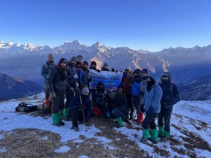
- People suffering from Bronchitis, Asthma, TB, Epilepsy(got faints)
- High blood pressure or higher BMI.
- Below 8 years are not allowed

Trek Equipments On Rent
Joshimath to joshimath, share your query pangarchullatrek, pangarchullatrek.
Trek Updates
- +91 9634923602
- +91 7895770439
- [email protected]

The Searching Souls – चल एक सफर पे
PangarchulLa Peak Trek
Send enquiry & get itinerary on whats app, pangarchulla peak trek.
- Flat 25% Off
- Joshimath to Joshimath all inclusive
- Highest Rated Trekking Company in India
- First Company to Introduce Jumbo Bag (Includes all Trekking Gear)
- Certified by Startup India, Uttarakhand Tourism, MSME and STU
- Top 10 Most Promising Adventure Travel Company in India
- Book Now at Just ₹ 1500
Trek Duration
Trek Distance
Difficulty Level
Best Season
₹10500 ₹7500
Joshimath to Joshimath
Call our Pangarchulla Peak Trek Expert Ms. Nidhi to know more about the trek
- Transportation available at ₹ 2000/person from Rishikesh to Rishikesh
- Jumbo Bag at ₹ 2500/person for entire Trek (Click here to know more)
- Transportation from Joshimath to Dhak road head and back
- Accommodation in Hotel/Guest House on Day 1 and Day 5
- All Meals (Veg only) included from Day 1 Dinner to Day 6 Breakfast
- Tents(Triple/Double Sharing), Sleeping Bags, Sleeping Matts
- Snow Grips/Micro Spikes and Gaiters as per snow conditions
- Experienced Trek Leader, Professional Guides and a very supportive staff
- Forest permits
- Medical Amenities –Medical Tents, Oximeter, Oxygen Cylinder, Stretcher, First Aid Kit
- Sanitised and Hygienic Camp sites and Hotels
- Anything not mentioned in inclusion list
- Meals during Transportation
- Any kind of personal Expenses
- Unscheduled or extended stay due to road blocks, Landslides
- Porter/mule charges (Personal), Back pack offloading Charges
- Cost of Evacuation in case of emergency
MODE OF TRANSPORTATION
- No of Persons (1-4) : Hatch Back - Alto, Swift or Equivalent Vehicle
- No of Persons (5-8) : Tata Sumo/Mahindra Bolero or Equivalent Vehicle
- No of Persons (9-12): Tempo Traveler
- Mar: 02, 03, 09, 10, 16, 17, 23, 24, 30, 31
- April: 06, 07, 13, 14, 20, 21, 27, 28
- May: 04, 05
- Transportation available at ₹ 2200/person from Rishikesh to Rishikesh
- Back Pack offloading ₹ 1400/person
SUMMARY Pangarchulla Peak Trek
Ready for adventure rent your trek gear today.
- Transportation from Joshimath to Joshimath
- No of Persons (1-4) : Sedan/Sumo/Bolero or Equivalent Vehicle
Pay Online To Book Pangarchulla Peak Trek
Check our google reviews for pangarchulla peak trek.

How We Make Treks Comfortable and Safe for you?

Pangarchulla Peak Trek Overview & Itinerary
Pangarchulla Peak Trek also known as the Chimney Peak, lies in the Nanda Devi Sanctuary. Perched at an elevation of 4483 metres, this trek offers everything that a trekker searches for, be it dusty and rocky trails, trails within dense coniferous forest and lastly a challenging and exhausting climb in deep snow with boulder hopping in between. This trek is a perfect example of non-technical mountain climbing. In short, it can be said that, Pangarchulla Peak Trek is a trek that just daredevils can’t afford to miss.
Spanning over 6 days, the journey starts from Haridwar till Joshimath, which serves as our base camp. The trek commences from Tugasi village from where the physical abilities of an individual are tested till day 5. From Tugasi, the trail opens up to cliff side villages, forests, open grassland and snow laden Himalayan Peaks in the background like Mt.Nanda Devi, Mt.Dronagiri, Mt.Kamet, Mt. Hathi-Ghoda, Mt.Neelkanth, Mt. Chaukhambha etc. .
What is special about Pangarchulla Peak trekking?
- If you are looking for a snow trek accessible in Summers Pangarchulla Peak Trek is the trek for you.
- It gives you a feeling of climbing a Himalayan peak without technical climbing
- One of the best summit to climb for trekkers.
- Beautiful camp sites.
- Ridge climb on the summit day.
- The view from the summit is mesmerizing where everything looks below your feet.
Pangarchulla Peak Trekking Trip Video
PANGARCHULLA PEAK TREK ITINERARY
- The trekkers will be picked up from Tapovan Rishikesh at 7.00 A.M from where the journey will begin. Rishikesh is well connected with Delhi through railway and road route. Overnight Buses and Trains are available. You can also take a flight to Dehradun and drive to Rishikesh, Dehradun Airport is closer to Rishikesh
- A 254 km to Joshimath from Rishikesh via, Devprayag and Rudraprayag. Breakfast and lunch during the travel will be provided in the road side inns. The meal cost during the travel will be paid by the individual.
- Arrival at Joshimath town and accommodation in a Guest house/Hotel. Dinner and rest at the guesthouse/hotel followed by a quick introduction and briefing session with the trek leader and fellow travelers.
- Drive to Tugasi village from Joshimath after breakfast. The trek will begin from Tugasi.
- The trail from Tugasi is of gradual ascend and comprises of dusty and rocky patches.
- Lunch and refreshments will be served midway between Tugasi village and Guling Campsite.
- Arrival at the campsite followed by evening refreshments, dinner and rest in the camps.
- Early morning trek to Khulara after breakfast covering a distance of 6 km.
- Khulara is a vast campsite surrounded by coniferous forests of oak, pine and rhododendron accompanied by a water streams all over the campsite area.
- The trek to Khulara from Guling is of moderate ascent.
- Arrival at the campsite till late lunch hours. Rest at the camps post lunch.
- An evening acclimatization walk to gear up for the next big day.
- Evening refreshments post acclimatization walk.
- Dinner and rest at the campsite.
- Early morning ascent to Pangarchula Peak after breakfast.
- Steepy and challenging climb of 6 km.
- Carry energy bars, Dry Fruits and water during the trail.
- Packed lunch in mid of the trail during the summit.
- Rest at the summit followed by descend to Khulara campsite.
- Evening refreshments at the campsite.
- Dinner and stay in the camps.
- Trek Down to Joshimath from Khulara campsite via Guling and Tugasi Village after breakfast.
- Trek till Tugasi village followed by drive to Joshimath from Tugasi.
- Lunch at Joshimath.
- Halt at a guest house/ Hotel in Joshimath.
- Dinner at Joshimath.
- Departure from Joshimath to Dehradun after breakfast.
- Arrival at Rishikesh at night by 8:00 PM
Trek Essentials
Tss jumbo bag.
- Backpack/Ruck Sack (at least 55 Litres) and a small day bag ( upto 15 litres) for summit day
- Poncho/Raincoat and Rain Cover for Ruck Sack
- 2 Quick Dry T-shirts (preferably Full Sleeves) and Track Pants
- Warm Jacket preferably a down jacket or an equivalent heavy jacket to protect from cold at night
- Comfortable Shoes with a good grip and ankle support. We recommend Quechua Forclaz 100 or similar shoe
- A pair of fleece jacket or fleece upper
- Good Thermals for insulation at night
- Lip Balm and Cold Cream
- Sun Cap or Sunscreen (SPF 30+)
- Dark Sunglasses. People who wear spectacle may use photochromatic lenses in their spects
- 2 pair of warm socks and at least 2 pair of normal cotton socks
- 1 Pair of slippers/Sandals
- Woolen Cap and Gloves for night
- Toiletries – Tooth brush, Tooth paste, Liquid soap, Hand Sanitizers, Slippers, Light Towel, Toilet Roll (Avoid wet tissues as they are not eco friendly)
- Torch or Headlamp with extra pair of batteries
- Personal Medical Kit: Crocin-Fever, Avomine-Motion Sickness, Avil 25mg – Allergies, Combiflam, Disprin-headache, Norflox TZ & Lomofen-diarrhea, digene-acidity, omez/rantadine antacid, crepe bandages, band aids, ORS, betadiene or antiseptic cream, moov spray/volini, cotton, gauze.
- Water bottle 1 L or Hydration bag 2 L
- Other personal accessories – Camera, Tripod, mobile charger, power banks(as there will be no electricity during the trek)
- Being a high altitude trek, this trek is suitable for climbers with good physical condition and stamina.
- This is a tentative itinerary which may change as per weather conditions
- We expect you to carry your rucksacks, in case if you want them to be carried by mules back pack offloading charge up to Rs. 300/bag/day is applicable
- In case of any natural calamity the company will not be able to refund the trip charges, for more details check our cancellation policy
Pangarchulla Peak Trek - A Mesmerizing Journey to the Summit
Embark on an adventure of a lifetime with the pangarchulla Peak trek, a popular trekking destination situated in the Garhwal region of the Indian Himalayas. Pangarchulla Peak Trek is stunning trek offers breathtaking views of the snow-clad mountains, verdant meadows, pristine lakes, and charming villages.
The pangarchulla Peak trek starts from the town of Joshimath and takes you through the beauty of the Auli meadows, the Gorson Bugyal, and the Tali Top. From here, the trail becomes more challenging as you ascend toward the summit. On the way, you’ll come across the Khullara and Kuari Pass, which offer stunning views of the surrounding mountains.
The panoramic views of the Himalayan ranges, including Nanda Devi, Trishul, and Dronagiri will leave you mesmerized during the summit. The view is truly awe-inspiring and will leave you feeling humbled by the grandeur of nature. The pangarchulla trek is perfect for adventure seekers who are looking for a challenging and rewarding trekking.
Why should you choose the Pancharchula Peak trek?
The pangarchulla Peak trek offers both stunning vistas and a challenging climb to its summit, which stands at an impressive 15,069 feet. On clear days, hikers can enjoy views of prominent Garhwal Himalayan peaks, such as Nanda Devi, Kamet, Hathi Ghoda Parbat, and Chaukhamba. The panoramic backdrop is dominated by the majestic Himalayan peaks of Chaukhamba (7138m), Neelkanth (6500m), and Dronagiri (70766m), adding to the awe-inspiring beauty of the trek.
Here are all the reasons why you should consider choosing the Pancharchula Peak trek as your next getaway:
- Starts from the town of Joshimath and takes around 7-8 days to complete.
- Takes you through the Auli meadows, Gorson Bugyal, and Tali Top.
- Becomes more challenging as you ascend toward the summit, which stands at 15,069 feet.
- Offers stunning views of Garhwal Himalayan peaks, including Nanda Devi, Kamet, Hathi Ghoda Parbat, and Chaukhamba.
- Offers encounters with diverse wildlife, including the Himalayan Tiger, Musk Deer, Wild Goats, Himalayan Bear, Leopard, and more.
How to reach the Pangarchulla Peak Trek?
To reach Peak Trek, you need to:
- Reach the town of Joshimath in Uttarakhand, India. You can reach Joshimath by road from Rishikesh or Haridwar. The nearest airport is Jolly Grant Airport in Dehradun.
- From Joshimath, you need to drive to the village of Dhak, which is the starting point of the trek. You can hire a taxi or take a shared jeep to Dhak from Joshimath.
- The trek starts from Dhak and takes you through Auli, Gorson Bugyal, and Tali Top, before reaching the summit of Peak.
- The trek is challenging and requires physical fitness and prior high-altitude trekking experience.
- It takes around 7-8 days to complete the trek, including acclimatization days.
- After completing the trek, you can either return to Joshimath or continue your journey to other nearby destinations, such as Badrinath or Valley of Flowers.
- It is advisable to check the weather conditions and get a guide before embarking on the trek.
FAQs for Pangarchulla Peak Trek
A: Pangarchulla Peak trek is a moderate level trek. There is a limited time period during which this trek can be successfully completed. Mid March to Mid May is an ideal time to do this trek as before march excess of snow makes it difficult to summit the peak and after may the snow melts and the trail has certain boulder zones which makes it very difficult to reach the summit.
A: Pangarchula Trek starts from Joshimath which is a base for many famous treks like Kuari pass, Auli Gorson bugyal, Kagbhusandi, Valley of Flowers etc. Pangarchulla is one of the few trekkable peaks at an elevation of 4500 m above sea level. It can be done by beginner, intermediate and experienced trekkers as well. The trail till Khulara camp site is same for Kuari Pass and Pangarchulla.
You can keep extra luggage in the base village for any particular trek. There are no cloak roo charges applicable. Its free of cost
If you are going on a trek don’t expect mobile signals. There are few spots on the trails of few treks where you might find a single tower or something but it always depends if that is enough to make a call or not.
As there are no permanent toilets on the trek, we carry toilet tents which are dry toilets so you need to carry wet tissues/tissue wipes with you.
Yes, TSS team can organize private batches for individual groups, but the cost of the trek may vary according to the number of members in your group. You can talk to our trek coordinator via whatsapp/call to get the customized group rates.
It’s a strict no. If you fall sick during the trek due to alcohol consumption TheSearchingSouls has the right to cancel your trek and send you back to base village. No expenses shall be refunded in that case and you will have to pay additional for stay at base village.
Start running/walking at least 3-4 Kms everyday.
If it’s a snow trek a good trekking shoe is mandatory. If you buy a new shoe do walk for few days so that it fits you well and doesn’t leave you with blisters while you trek. If it is a summer trek or post monsoon trek a shoe with good grip and ankle support will do.
We provide 3 Veg meals and evening Snacks. There will be no non veg served during the trek. Eggs may or may not be served depending on the trek.
We will provide sleeping bags, inner liners, sleeping mats, tents. You just need to carry your personal gear. List of personal Gear is in our website under Trek Essentials.
Himalaya Journeys Treks &Expedition prides itself on being prepared for any emergency situation. Our guides are trained in first aid and can deal with most of the basic ailments that occur during a trek. Every camp site has basic first aid and oxygen cylinders But if a serious emergency occurs, we will evacuate you to the base village and nearest hospital but the expenses of that has to be borne by the individual
Pangarchulla Peak Trek Map
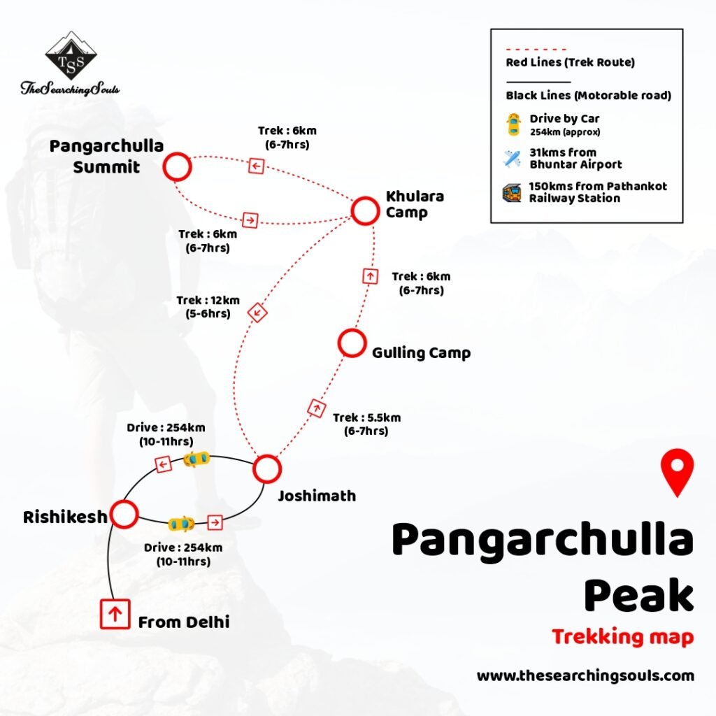
Why Book with TSS?

Safety with TSS
The Searching Souls have always taken Safety as the utmost Priority in their Treks. We Have a “Zero Negligence” approach toward Safety. As a result, we have taken the Following Steps.
Medical Tents: TSS is the Only Company in the Country that Pitches dedicated Medical Tents to The Slopes at all their Campsites. The Medical Tents consist of a Stretcher, Oxygen Cylinder, First Aid Kits, Oxymeters, and a few other facilities depending on the Slope and the nature of The Terrain.
Qualified Trek leaders: All Our Trek Leaders are Qualified From the Nehru Institute of Mountaineering and have thorough knowledge and experience of the Mountains.
Emergency Planning: Team TSS always plans a step ahead in the Mountains as we believe anything at any time can happen in the Mountains, All Our trek leaders, Camp managers, and Cooks are aware of what should be the Course of Action in case of Medical Emergency and Natural Calamities.
TSS Support Team: Safety in the Mountains begins at Home, Proper Planning and preparation are Key in any Mountain Trek. TSS Support Team is always available and will help you prepare better for the Trek through their Expert Knowledge and Guidance.
TSS Jumbo Bags: For executive travelers seeking adventure, trekking is a popular way to explore unfamiliar terrain and find inner peace. However, selecting the right equipment can be crucial to ensure safety and comfort during the journey. TSS recognizes this and offers a solution with their MY JUMBO BAG – BUDDY, which includes all necessary gear for a high-altitude trek at an affordable price. The company also emphasizes the importance of quality equipment in ensuring a successful and memorable trek, while cautioning against overpriced or unnecessary items. With TSS, travelers can confidently embark on their trek, knowing they have a reliable companion in their trek bag.
Are you tired of spending a fortune on expensive trekking equipment? Look no further than MY JUMBO BAG – BUDDY.
Why Experience the Magic of Pangarchulla Peak Trek with The Searching Souls?
Expertise: The Searching Souls is a team of experienced trek leaders who are passionate about sharing their love for the outdoors with others. They have extensive knowledge of the Pangarchulla Peak Trek and the surrounding areas, ensuring that you have a safe and enjoyable experience.
Personalized attention: The Searching Souls focuses on small group sizes, allowing them to provide personalized attention to each trekker. They take the time to understand your individual needs and interests and customize the trek to ensure that you have the best experience possible.
Safety: Safety is a top priority for The Searching Souls. They provide all necessary safety equipment, including first aid kits and emergency communication devices, and their trek leaders are trained in wilderness first aid.
Responsible tourism: The Searching Souls is committed to responsible tourism practices. They follow Leave No Trace principles, minimizing their impact on the environment and also supporting local communities by using local guides and porters.
Memorable experience: The pangarchulla Peak trek with The Searching Souls is not just a trek, but an experience. From the stunning views of the Garhwal Himalayas to the warmth of the local hospitality, the trek is sure to leave you with memories that will last a lifetime.
Unlock Your Inner Adventurer with The Searching Souls – Join Our Trekking Journeys and Create Memories that Last a Lifetime!
Related Treks

Dayara Bugyal Trek
Hike to a high altitude meadow considered among the highest & largest meadows of the Himalayas offering a panoramic view of gigant...

Gaumukh: The Source of...
Hike to Gaumukh is a challenging trek with scenic views.It is a glacier in the Himalayas which is the source of the Ganges River. ...
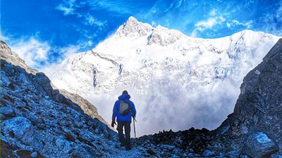
Goechala Trek
Nestled at a height of 15,100 ft, with a closer look at the third-highest peak-Mt. Kanchenjunga Goechala Trek is a dream and desire ...

Pindari Glacier Trek
Pindari Glacier is one of the best treks in Kumaon region of Uttarakhand and a very easy one to begin with.
FULFIL DREAMS
At The Searching Souls, we intend to encourage people, to take out time from their busy lives and join us on a journey of self-exploration in the Himalayas.
Address Lane No 3, Friends Enclave, Near Siddhartha law college, IT Park, Sahastradhara Rd, Dehradun, Uttarakhand 248013
Daily Business Hours: 9 AM to 9 PM
Call: +91- 9634923602, 7895770439
IN A NUTSHELL
Certified by StartUpIndia, MSME and Uttarakhand Tourism, we are a 5 Star Rated Company with a 95% Customer Satisfaction Score. We deal in Trekking in the Himalayas, Customized group tours.
- Trekking Himachal Uttarakhand Maharashtra Expeditions South India Kashmir Summer Kheerganga Trek Laka Glacier Trek Indrahar Pass Trek Bhrigu Lake Trek Hampta Pass Trek Beas Kund Trek Sar Pass Trek Prashar Lake Trek Moon Peak Trek Kasol Kheerganga Trek Rupin Pass Trek Winter Hampta Winter Trek Bir Winter Trek Dalhousie Winter Trek Sar Pass Circuit Trek All Season Kareri Lake Trek Grahan Trek Tosh Trek Triund Trek Summer Har Ki Dun Trek Rupin Pass Trek Bali Pass Trek Ali Bedni Trek Ruinsara Tal Trek Pangarchulla Trek Winter Kuari Pass Trek Chopta Chandarshila Tungnath Trek Brahmatal Trek Roopkund Trek Kedarkantha Trek All Season Dayara Bugyal Trek Gaumukh Tapovan Trek Nag Tibba Trek Monsoon Kedartal Trek Valley of Flowers Trek Forest Treks Kalsubai Trek Sandhan Valley Trek Andharban Trek Bhimashankar Trek Devkund Trek Fort Treks Rajmachi Trek Prabalmachi Trek Visapur Fort Trek Lohagad Fort Trek Nepal Everest Base Camp Annapurna Base Camp India Goechala Trek Chadar Trek Weekend Treks Kudremukh Trek Kodachadri Trek Kumara Parvatha Trek Gokarna Beach Trek Tadiandamol Trek Dudhsagar waterfall Trek Netravathi Peak Trek Bandaje Falls Trek Kurinjal Peak Trek Sunrise Treks Skandgiri Trek Uttari Betta Trek Kunti Betta Trek Anthargange Trek Savandurga Trek Makalidurga Trek Ramanagara Night Trek Nandi Hills Trekking Popular Treks Kashmir Great Lakes Trek Tarsar Marsar Trek Tulian Lake Trek Naranag Gangabal Trek
- Bike Trip Ladakh Others Full Circuit Manali Leh Srinagar Srinagar Leh Manali Exclusive Routes Delhi Srinagar Leh Delhi Leh Umling la Leh Manali to Leh Bike Trip Leh to Leh Leh to Leh (7D/6N) Leh to Leh (6D/5N) Other Bike Trips Uttarakhand Meghalaya Rann of Kutch Rajasthan tawang Bhutan
- Camping Himachal Uttarakhand Bangalore Mumbai Best for Camping Kasol Manali Kullu Workcation Workation camps in Bir Workation Cottage in Jibhi Workation camps in McLeod Ganj Workation Camps in Tosh Trending Camping Sites Rishikesh Kanatal Lansdowne In Bangalore Ramanagara Nandi Hills Kanakapura Nearby Bangalore Dandeli Coorg Camping Sakleshpur Camping Wayanad Camping Gokarna Camping and beach Trek Popular Pawna Lake Camping Bhandardara Camping Revdanda Beach Camping Offbeat Kolad Camping Karnala Camping
- Tours Uttarakhand Ladakh Goa Andaman Spiti Delhi to Delhi Karnataka Mumbai Departure Religious Tours Kedarnath Yatra Rishikesh Spiritual Do Dham Yatra Char Dham Yatra Popular Tours Rishikesh Rishikesh Food Walk Jim Corbett Rishikesh Night Walk Delhi to Auli Tour Popular Tours Manali To Srinagar Leh Ladakh From Delhi Srinagar To Leh Leh Turtuk Village Popular Tours 4 Days Goa Grande Island Backpacking Tours Backpacking Tour 8 Days Offbeat Honeymoon Tours Honeymoon Tour 5 Day Honeymoon Romantic Candlelight Beachside Honeymoon 4 Days Honeymoon Popular Tours Spiti From Manali Spiti Circuit Trending Tours Mcleodganj Triund Kasol Kheerganga Jibhi Tirthan Manali to Solang Valley Manali and Lahaul Trip Chopta Chandrashila trek Mcleodganj Kareri Trek Manali, Solang and Kasol Tour 1 Day Tour Packages Adiyogi Laser Show Adiyogi & Gudibande Fort DD Hills & Mandaragiri Hills Hogenakkal Waterfalls Mysore 2 Days Tour Packages Hampi Tour Package Kodaikanal Tour Package Munnar Tour Package Ooty Tour Package Wayanad Tour Package Chikmagalur Tour Package Coorg Tour Package Pondicherry Tour Package Dandeli Tour Package Sakleshpur Tour Package Kannur Tour Package Udupi Mangalore Tour Valparai Tour Package Thekkady Tour Package Br Hills Tour Package Badami Tour Package Gokarna Murudeshwar Gokarna Tour Package 3 Days Tour Packages Hampi Tour Package Chikmagalur Tour Package Coorg Tour Package Wayanad Tour Package Goa Tour Package Gokarna, Honnavara & Murudeshwar Gokarna, Dandeli & Murdeshwara Mumbai To Mumbai Hampi Gokarna Murudeshwar Dandeli Gokarna Murudeshwar
- Activities Air Activities Water Activities Land Activities Himalayas Paragliding In Bir Paragliding In Manali Paragliding at Dharamshala Bungee Jumping at Rishikesh Giant Swing in Rishikesh Flying Fox in Rishikesh Mumbai Kamshet Paragliding Helicopter Ride in Mumbai Rajasthan Parasailing in Jaisalmer Paramotoring in Jaisalmer Hot Air Balloon in Jaipur Bangalore Helicopter Ride Microlight Flying Bangalore Andaman Scuba In Andaman Scuba In Havelock Snorkeling Kayaking Glass Boat Ride Mumbai Cruise Dinner Helicopter Ride Kolad River Rafting Luxurious Boating Himalayas Rafting in Kullu Rafting in Rishikesh with Camping Goa Titos Club Big Daddy Casino Rajasthan Candle Light Dinner Quad Biking in Jaisalmer ATV Buggy Ride in Jaipur Paintball in Jaipur Jhalana Leopard Safari in Jaipur Bangalore Wine Tasting Tour Wonderla Amusement Park Maharashtra Kolad Camping
- Places India International Himalayas Jammu Kashmir Bir Bhuntar Tosh Tirthan valley Jibhi Kullu Manali Dharamshala Leh Kasol McLeodganj Spiti Valley Malana South India Bangalore Chikmagalur Coorg Hampi Mysore Dandeli Sakleshpur Others Andaman Nicobar Jaipur Best International Dubai Indonesia Thailand Singapore Malaysia
- Pilgrimage Uttarakhand By Helicopter Char Dham Yatra By Helicopter Do Dham Yatra By Helicopter Do Dham In 1 Day Hemkund Sahib In 1 Day Do Dham Ex- Sersi Kedarnath By Helicopter By Road Char Dham By Road Tungnath Temple By Road Kedarnath Yatra
Pangarchulla Trek

Pangarchulla Trek Highlights
- Easy Booking Platform
- Best Price Guaranteed
- Exclusive Offers
Pangarchulla Trek Overview
About pangarchulla trek:.
Pangarchulla is one of our most coveted summit climbs. If timed right, the summit climb to Pangarchulla is out of the world! You make your way to 15,010 ft up a summit ridge, which gives a very high feeling of adventure. This is a challenging trek. The climb to the summit takes the wind out of you, which is why it needs proper training for at least a month and a half before you attempt it. But if you’re fit and well-prepared, I don’t think anything would match up to the high you get when you climb the Pangarchulla summit. Exposed. The trek becomes very difficult to navigate. A big bonus that most trekkers tend to miss is the views on the trek. The Pangarchulla trek passes through the Nanda Devi Sanctuary. So the trail is blessed with views of Mt.Nanda Devi, Chaukhamba, Dunagiri, Hathi Parbat, Ghori Parbat, and more. These are a real treat for the eyes!
Pangarchulla Trek Quick Facts
➔ Starting & Ending Point: With Transport: Dehradun/Rishikesh/Haridwar
➔ Starting & Ending Point: Without Transport: Joshimath
➔ Duration: 6 Days 5 Nights
➔ Distance: 37 km (to and fro)
➔ Maximum Altitude: 15,069 ft (4,593 m)
➔ Difficulty Level: Easy To Moderate
➔ Temperature: Day (6°C to 16°C) and Night: (-6°C to 4°C)
➔ Best Time: August to October & March to May
➔ Nearest Railway Station: Dehradun Railway Station
➔ Nearest Airport: Jolly Grant Airport, Dehradun
Pangarchulla Trek Inclusions:
- Meals - From Dinner On Day 1 to Breakfast on Day 6 - Vegetarian Nutritious Food - Breakfast, Lunch, Hi-Tea, Dinner
- Equipment: Tents(Triple/Double Sharing), Sleeping Bags, Sleeping Matts
- Gears: Snow Grips/Micro Spikes and Gaiters as per snow conditions
- Accommodation in Hotel/Guest House/Camps On Sharing Basis From Day 1 and Day 5
- Experienced Trek Leader, Professional Guides, and a very supportive staff
- Forest permits For Pangarchulla Trek
- Medical Amenities – First Aid Kits, Oxymeters, oxygen cylinders.
How to reach:
➔ As You see above, We have two Pangarchulla trek packages, one includes transport from Dehradun to Joshimath, and one without it.
➔ If you have chosen the alternative which includes transport, then you simply have to meet us at Dehradun.
➔ To reach Dehradun, you can take a direct flight to the Jolly Grant Airport from Delhi.
➔ You can also take a direct train, or even a bus from Delhi, at your convenience.
➔ Alternatively, you can directly reach the Joshimath base camp by taking a direct bus from Dehradun to Joshimath.
➔ However, we suggest you join us from Dehradun. The drive from Dehradun to the Pangarchulla base camp itself is enough to bedazzle you.
Itinerary For Pangarchulla Trek
Day 1 - Drive from Dehradun/Rishikesh Joshimath (2450 m, drive of 280 km, 8-9 hour)
Arrive at Joshimath and unwind at a lodge/hotel And Enjoy Night
- Start your tour by meeting at the Dehradun Railway station at 6:00 AM, and from here, drive to Joshimath.
- Dehradun is connected diversely with Delhi through railway and road routes. Overnight Buses and Trains are available on a daily basis. You can also take a flight to Dehradun (Jolly Grant Airport).
- This drive will surpass through Devprayag and Rudraprayag's holy townships as you follow the rivers Ganga and Alaknanda.
- Arrive at Joshimath and unwind at a lodge/hotel arranged for you where you could spend the night.
- Get started with the orientation session, where you discover deeply the trek you are going to embark tomorrow!
Day 2 - Trek from Joshimath Guling (2928 metres, 12 km drive and 5.5 km trek)
Capture Sights of Nanda Devi Peak And Other Majestic Mountains
- Start your day with a delectable breakfast, and after a short drive of 5 km to Dhak, reach the point where you can begin hiking to Guling.
- Cut through meadows in Auli that make an ideal skiing location.
- On the way, capture sights of Nanda Devi peak and other majestic mountains.
- Climb down to arrive at another thickets expanse with Oak, Chestnut, Deodar, and Maple trees.
- Lunch and refreshments will be served midway between Tugasi village and Guling Campsite
- After a long walk, reach Guling's camp, flourished with a meadow and sights of mountainous landscapes.
- Set up camp here in tents and retire for the night under the star-lit sky.
Day 3 - Trek from Guling to Khulara Campsite (3389 metres, 6 km trek)
The trek to Khulara from Guling
- Begin with an early breakfast, after which you can start your trek to Kluara.
- Khulara is a vast campsite surrounded by coniferous forests of oak, pine and rhododendron accompanied by a water streams all over the campsite area.
- The trek to Khulara from Guling is of moderate ascent.
- Arrival at the campsite till late lunch hours. Rest at the camps post lunch.
- An evening acclimatization walk to gear up for the next big day.
- Evening refreshments post acclimatization walk.
- Dinner and rest at the campsite.
Day 4 - Khulara to Pangarchula Summit and back to Khulara (4575 metres, 12 km trek)
Ready to Pangarchula Peak
- Early morning ascent to Pangarchula Peak after breakfast.
- Steepy and challenging climb of 6 km.
- Carry energy bars, Dry Fruits and water during the trail.
- Packed lunch in mid of the trail during the summit.
- Rest at the summit followed by descend to Khulara campsite.
- Evening refreshments at the campsite.
- Dinner and stay in the camps.
Day 5 - Khulara to Joshimath (2050 metres, 11.5 km trek and 12 km drive)
Explore Guling and Dhak Village
- Trek Down to Joshimath from Khulara campsite via Guling and Dhak Village after breakfast.
- Trek till Dhak village followed by 12 km drive to Joshimath from Dhak.
- Lunch at Joshimath.
- Halt at a guest house/ Hotel in Joshimath.
- Dinner at Joshimath.
Day 6 - Drive from Joshimath Dehradun (drive of 280 km, 8-9 hours)
- Departure from Joshimath to Dehradun after breakfast.
- Arrival at Dehradun at night by 9:00 PM
Our Destination expert will be happy to help you resolve your queries for this tour.
- All in one platform
- Never Settle for Average
- Truly Unique Experiences
Select Package Options
Please select a tour date
Please select a tour package
Total Travellers
Variant description, things to carry, location details about pangarchulla trek.
Starting Point
Pangarchulla Trek Reviews
Tanmay agrawal, good experience.
This is my first trip and I am very happy to see the Pangarchulla Peak with my friends. This is a very good expedition by trekking different kinds of layouts like meadows, muddy, forestry, rocky, snowy, etc

View Images
Good timing
I recently did the Pangarchulla Trek in Uttarakhand and it was amazing! You may see bears or Ghoral (mountain Got) while climbing, the difficulty level is moderate to difficult, as you go high you might feel light-headed or some may get breathless because of the high altitude.
Heena Pandav
Beautiful nature.
The good thing about this trek is that you can experience all kinds of terrain while trekking and enjoying. One should do this trek if he/she wants to meet nature and wants to feel it It was awesome. Good communication and well manor of their people.
Sandesh Singh
View points are awesome.
I am very happy with this beauty of excellence and It takes almost 3 days to climb to the top from the base village of Joshimath. it is a Great trek with a great view
Rohan Bagdai
Looking pretty.
Amazing experience and...thrilling climb The view from the top is Awesome One of the lesser-known Himalayan treks. Mesmerizing views. The ascent was steep and challenging, but it was totally worth it for the incredible views from the top.
Wonderful Experience
This trek is one of the most difficult treks that can be done within 6-7 days But we fully enjoy this trek mostly hills, and mountains, and suffer in the train. All those movements are memorable for the lifetime
Satyen Naik
Once a lifetime experience, I want to Thank, Banbanjara for this amazing arrangement, we had a good operator and staff who assist us in the whole tour with perfection... Everything went awesome and we really felt comfortable with everything.
Bodhan Mehrotra
Suitable for group adventure, you will get to discover beautiful snow terrain, mighty mountain peaks, lush green forests, and some hot water springs too. Pangarchulla Peak trek via Kuari Pass in Auli is a complete paradise for trekking lovers.
The trek was not too strenuous and suitable for slightly older people like me. Felt a little stiff every now and then, but the trek leader was very cooperative and would slow down to give me a few minutes of rest. Returned home safe and sound.
Related Tours

Brahmatal Trek Package

Kuari Pass Trek with Camping

Kedarkantha Trek Package

Dayara Bugyal Trek

Your Joshimath Travel itinerary is waiting.
Receive a curated itinerary featuring the most iconic experiences in Pangarchulla Trek, straight to your whatsapp.
Pangarchulla Trek FAQs
When is the best time do pangarchulla peak trek, what all things i should carry for the pangarchulla peak trek via kauri pass.
There are a couple of things that are essential to carry for a trek. A 60 litres backpack with plastic or waterproof lining High-ankle trekking shoes with good grip (Shoes with thick souls are recommended) Trekking pole or stick Wardrobe essentials like woollen and fleece clothes, synthetic or waterproof track pants, rain-proof jackets, sunglasses, waterproof gloves, wind-proof jackets, thermal inner wear Moisturizer, Sun Screen Lotion, Lip Balm Sun Glass Personal Medicine Kit Insulated water bottle & hydration pack (optional) Flashlight and extra batteries Extra Polythene bags.
What attractions we can see during this trek?
For mountain lovers, this trail offers king-size views of the Himalayas and an opportunity to be transported into the inner Himalayan region in a very short duration. The trek is not only spectacular but very different from everything else. You will for most of the times be walking on endless meadows with big and small mountains jutting out. There are beautiful forest sections, magnificent campsites, and sunrise & sunsets to die for, in addition to many more enjoyable facets of the Himalayas which make trekking a worthwhile activity. You will also get the opportunity to meet and interact with shepherds and their entourage and surely be bowled over by their way of life.
Confirmation Policy
- Upon booking, the traveller will receive a confirmation voucher via email, within 24 hours.
- In the special cases of slots not being available, feasible alternatives will be provided to the customer, in regards to the customer’s preference. In such cases, a new voucher would be sent via email, consisting of the new travel details.
Cancellation Policy
- Any cancellation made 25 days before the date of departure, would levy 15% of the total tour cost as cancellation charges.
- Any cancellation made within 15-25 days before the date of departure, would levy a 25% of total tour cost as cancellation charges.
- Any cancellation made within 7-15 days before the date of departure, would levy 50% of the total tour cost as cancellation charges.
- Any cancellation made within 0-7 days before the date of departure, would levy 100% of the total tour cost as cancellation charges.
- Due to any restrictions such as sudden government policies or regulations, health hazards, medical emergencies, or unprecedented weather conditions, activities and tours may be nonoperational and be canceled. In cases such as these, operators will attempt to cater to the traveler as an alternate, which is feasible in nature. However, any refund would not be catered.
Refund Policy
- Any refund applicable will be processed within 7 business days.
- Travel in small groups.
- An additional fee of INR 250 can be paid for extra porters per day to avail of their services and carry personal belongings throughout the trek.
- If you prefer your sleeping bag, you can buy new sleeping bags at reasonable rates from the store.
- One can even opt for personal trekking gear, and extra oxygen can come at an additional cost.
- Ensure proper waste disposal.
- Respect local cultures and be sensitive to wildlife.
- General precautions and steps are to be taken to initiate good acclimatization with the assistance of guides.
- Those suffering from an ailment or heart disease, diabetes, breathing problems, high altitude sickness, or is pregnancy cannot participate in this trek.
- Guidelines issued by the state government are to be followed.
- Social distancing is to be maintained.
- Frequent hand sanitization and the use of masks are recommended.
- Please provide a valid ID at the time of check-in.
- The exact location will be shared with you post-booking.
More things to Do
Trek Difficulty
Trail Length
Highest Altitude
Best Domestic Packages
Popular on banbanjara, places to visit in india, international places to visit.
Recommended
Popular Tours

Auli Package From Delhi
Starts from ₹6499

Spiti Valley Winter Tour From Delhi
Starts from ₹12500

Jibhi Tirthan Valley Trip from Delhi
Starts from ₹6999

Chopta Tungnath and Chandrashila Trek Package
Starts from ₹3899

Manali, Solang and Kasol Tour Package
Starts from ₹7100

Lakshadweep Tour Package From Mumbai
Starts from ₹22000

Bangalore to Coorg Tour Package
Starts from ₹3287

Bangalore to Kodaikanal Package
Starts from ₹6206

Kedarnath Yatra With Pick Up From Delhi & Haridwar
Starts from ₹8499
Trek Of india

Starts from ₹5699

Starts from ₹5999

Kheerganga Trek with Camping
Starts from ₹1150

Triund Trek & Camping, McLeod Ganj
Starts from ₹830

Starts from ₹7950

Kareri Lake Trek with Camping
Starts from ₹1500

Laka Glacier Trek via Triund
Starts from ₹3199

Starts from ₹5299

Nag Tibba Trek
Starts from ₹1499
Log into Your Account
Create your account.
Username or E-Mail
Forget Password?
Do not have an account?
Already a member.
- Uttarakhand
- Himachal Pradesh
Pangarchulla Trek 2024
- Departure & Return Location Dehradun (Prince Chowk)
- Departure Time 6:30 AM - 7:30 AM
Pangarchulla also known as the Chimney Peak, lies in the Nanda Devi Sanctuary. Perched at an elevation of 4483 metres, this trek offers everything that a trekker searches for, be it dusty and rocky trails, trails within dense coniferous forest and lastly a challenging and exhausting climb in deep snow with boulder hopping in between. This trek is a perfect example of non-technical mountain climbing. In short, it can be said that, Pangarchulla Peak is a trek that just daredevils can’t afford to miss. Spanning over 6 days, the journey starts from Haridwar till Joshimath, which serves as our base camp. The trek commences from Dhak village from where the physical abilities of an individual are tested till day 5. From Dhak, the trail opens up to cliff side villages, forests, open grassland and snow laden Himalayan Peaks in the background like Mt.Nanda Devi, Mt.Dronagiri, Mt.Kamet, Mt. Hathi-Ghoda, Mt.Neelkanth, Mt. Chaukhambha etc.
What is special about Pangarchulla trekking?
- If you are looking for a snow trek accessible in Summers Pangarchulla is the trek for you.
- It gives you a feeling of climbing a Himalayan peak without technical climbing.
- One of the best summit to climb for trekkers.
- Beautiful camp sites.
- Ridge climb on the summit day.
- The view from the summit is mesmerizing where everything looks below your feet.
Price Includes
✓ Accommodation
Neat, clean, hygienic accommodation on Triple / Quad Sharing as per your preferences. Accommodation during the trek will be in camps
✓ Transportation & Taxes
Inclusive of transport services for 3 Nights & 4 Days. (Ex Haridwar). All toll, tax, parking and driver allowances are included.
✓ Meals (Breakfast & Dinner)
Veg Only All Breakfast & Dinner. Note:(Lunch is not included.)
✓ Sight Seeing
All point to point sight-seeing as per given program possible in time frame.
✓ Safety equipment
- First Aid Kit
- Oxygen Cylinder
✓ Permits & Registrations
- Trekking permits and forest camping charges.
Price Excludes
- Anything not mentioned in inclusion list
- GST @ 5 Percent
- Meals during Transportation and Lunch
- Any kind of personal Expenses
- Unscheduled or extended stay due to road blocks, Landslides
- Porter/Mule charges (Personal), Back pack offloading Charges
- Cost of Evacuation in case of emergency
Day 1 - Dehradun to Joshimath
- The trekkers will be picked up from Dehradun Railway Station at 6.00.a.m. from where the journey will begin. Dehradun is well connected with Delhi through railway and road route. Overnight Buses and Trains are available. You can also take a flight to Dehradun
- A 280 km road ride to Joshimath from Dehradun crossing the cities of Rishikesh, Devprayag and Rudraprayag. Breakfast and lunch during the travel will be provided in the road side inns. The meal cost during the travel will be paid by the individual.
- Arrival at Joshimath town and accommodation in a Guest house/Hotel. Dinner and rest at the guesthouse/hotel followed by a quick introduction and briefing session with the trek leader and fellow travelers.
Day 2 - Joshimath to Guling Campsite
- Drive to Dhak village from Joshimath after breakfast on a 12 km drive route. The trek will begin from Dhak village.
- The trail from Dhak is of gradual ascent and comprises of dusty and rocky patches.
- Lunch and refreshments will be served midway between Tugasi village and Guling Campsite.
- Arrival at the campsite followed by evening refreshments, dinner and rest in the camps.
Day 3 - Guling to Khulara Campsite
- Early morning trek to Khulara after breakfast covering a distance of 6 km.
- Khulara is a vast campsite surrounded by coniferous forests of oak, pine and rhododendron accompanied by a water streams all over the campsite area.
- The trek to Khulara from Guling is of moderate ascent.
- Arrival at the campsite till late lunch hours. Rest at the camps post lunch.
- An evening acclimatization walk to gear up for the next big day.
- Evening refreshments post acclimatization walk.
- Dinner and rest at the campsite.
Day 4 - Khulara to Pangarchula Summit and back to Khulara
- Early morning ascent to Pangarchula Peak after breakfast.
- Steepy and challenging climb of 6 km.
- Carry energy bars, Dry Fruits and water during the trail.
- Packed lunch in mid of the trail during the summit.
- Rest at the summit followed by descend to Khulara campsite.
- Evening refreshments at the campsite.
- Dinner and stay in the camps.
Day 5 - Khulara to Joshimath
- Trek Down to Joshimath from Khulara campsite via Guling and Dhak Village after breakfast.
- Trek till Dhak village followed by 12 km drive to Joshimath from Dhak.
- Lunch at Joshimath.
- Halt at a guest house/ Hotel in Joshimath.
- Dinner at Joshimath.
Day 6 - Joshimath to Dehradun
- Departure from Joshimath to Dehradun after breakfast.
- Arrival at Dehradun at night by 9:00 PM
Payment & Cancellation Policy
Payment policy.
- You can book your tour with us at 20% advance to get the confirmation.
- Confirmation will be expedited within 24 hours (one working days) after the booking amount.
- Balance payment is to be made on arrival at the pickup location before the commencement of the tour.
Cancellation Policy
Make your booking 15 days prior in advance. If you cancel the trek due to any reason, it is mandatory to notify us. Cancellation charges will only be effective from the date we get your request to cancel the trek. If the trek gets cancelled from our side due to any reason (heavy snowfall, rainfall, natural disaster etc.) then the refund will not be initiated but we will arrange another trek. Note :- If your trek starts once, and in between 2 or 4 days at the time of the trek, the weather gets bad or the trek route is closed for some reason due to which the trek cannot be done, then the company will not refund the any money to you.
- All the preparations of the company are behind this, for which you cannot blame the company.
- The company can suggest some other good and safe trek for you at that time – which will be done at the same cost.
- And if it does not happen near that place then it would be better to cancel the trek.
- Trek On India can do this for you by deducting the payment for the number of days you trekked and giving you a voucher or coupon code for 1 year
- You can use a Voucher or Coupon Code for another trek within 1 year
- If for any reason you return from the trek at the time of the trek, then no payment will be refunded to you.
- And if you have booked a trek of 6 days and if you have completed 5 days then you cannot ask for a refund of 1 day.
The cancellation charges are as follows –(Bank charges deducted are not Refundable)
- Up to 30 Days – 90% cost is Refundable
- Between 21 to 30 Days – 50% cost is Refundable
- Less than 20 Days – No Refund
(Refund is initiated within 7-8 business days)
When is the best time to do Pangarchulla Peak Trek
The months of April, May, October and November are considered to be the best time for Pangarchulla peak trek to enjoy a blissful session of trekking towards the summit. While April and May experience hot climatic conditions, it becomes easy for trekkers to save themselves from scorching heat and get clearer paths. During the months of October and November, the winter has just begun here, which results in a cozy climate loaded with many beautiful sceneries. Hence, these four months are the best time for Pangarchulla peak trek.
What level of fitness is expected from me?
This is a moderate trek barring one challenging day when you will literally be atop of the world when you get to the Pangarchula peak at about 15069 ft. It’s a challenging trek only recommended to trekkers who have done a trek of 14000 ft. And beginners who have physical fitness on a scale of 7-8.
What all things I should carry for the Pangarchulla Trek ?
There are a couple things that are essential to carry for a trek.
- A 60 liters backpack with a plastic or water-proof lining
- High-ankle trekking shoes with good grip (Shoes with thick souls are recommended)
- Trekking pole or stick
- Wardrobe Essentials like woolen and fleece clothes, synthetic or waterproof track pants, rain-proof jackets, sunglasses, waterproof gloves, wind-proof jackets, thermal inner wear Moisturizer, Sunscreen Lotion, lip balm
- Personal medicine kit
- Insulated water bottle & hydration pack (optional)
- Flashlight and extra batteries
- Extra polythene bags
What kind of shoes I should have?
You should carry high-ankle trekking shoes. Different shoes are suitable for different kinds of treks, depending on the weather, trail condition as well as duration of the trek. For this particular trek, shoes with thick souls are recommended.
How is Pangarchulla Peak trek weather?
For mountain lovers this trail offers king size views of Himalayas and an opportunity to be transported into inner Himalayan region in a very short duration. The trek is not only spectacular but very different from everything else. You will for most of the times be walking on endless meadows with big and small mountains jutting out. There are beautiful forest sections, magnificent campsites, and sunrise & sunsets to die for, in addition to many more enjoyable facets of the Himalayas which make trekking a worthwhile activity. You will also get the opportunity to meet and interact with shepherds and their entourage and surely be bowled over by their way of life.
What is the difficulty level of Pangarchulla Peak Trek?
Pangarchulla Trek is considered as a difficult one. Because of the high altitude of over 15,000 feet at a distance of 38 km with a strong peak near the peak and the landscape claims for an experience of at least one Moderate to Difficult high altitude trek. The summit requires a significant level of fitness and endurance. But the breathtaking views of the mountains, villages and the prominent peaks repay all the challenges of the trek.
How much do we have to trek each day?
We will be covering about 5-6 km initially. Later on trek hours will increase to 12 hours for 3 days, overall experience will be moderate level grade.
Is Pangarchulla Peak Trek safe?
Yes, Pangarchulla Peak Trek is safe because all sort of safety parameters is kept in place before the trek begins. You will be accompanied by a trained instructor who will guide you throughout the trek and each guide will lead a group of 6 people. All you need to do is to listen carefully to the instructions provided by the guide as these instructions will make your trekking experience easy and safe. It is requested to wear high-ankle trekking shoes with good grip and trekking pole or stick for your self-safety. For your further safety, you will be equipped with Camping and trekking equipment such as Sleeping bags, Imported Inflatable Camping Mattresses, Camping stools, Mess Tent, Toilet tent with portable toilet seats and many more. You can even opt for personal trekking gear and extra oxygen can at an additional charge.
What is the Pangarchulla Peak altitude and what is the total Pangarchulla trek distance?
The Pangarchulla Peak stands tall at an altitude of 15,069ft and the trek distance is around 38 km. The trek will take you through some of the majestic views of the region with the snow-capped mountains and the verdant valleys. For the adventure seekers and the thrill seekers, this is a must do trek. The snow-covered mountains offer a different kind of beauty that cannot be comprehended unless you have witnessed it yourself.
What are washroom/toilet facilities like on the trek?
While you are staying at the guest house at Joshimath you will have concrete toilets. During your trek, there will be toilet tents set up along each campsite. There will be 2 or 4 of these toilet tents depending on the size of the group. These toilet tents will have a deep pit, for your nature call. Also, there will be a mound of soil and a shovel to cover it up. These are dry toilets so use toilet paper. There will be a room freshener as well. Also, use plain toilet paper and refrain from using wet wipes since these are not bio-degradable.
What is the average temperature at Pangarchulla Peak Trek?
The maximum temperature at Pangarchulla Peak Trek is 23 degrees Celsius. The temperature of Pangarchulla Peak during the February month is -10 to +15 degree Celsius. When it comes to March month, the temperature goes to -5 to +15 degree Celsius. And, the temperature goes down to -2 to +17 to degree Celsius during April month. The average temperature during the day time is 14°C to 18°C and -3°C to -6°C during the night time.
- Dehradun From Dehradun To Dehradun
- Joshimath From Joshimath To Joshimath
Proceed Booking
Already a member.
Username or E-mail
Don't have an account? Create one.
Or continue as guest, adding item to wishlist requires an account, book with confidence.
+91-8800506998 [email protected]
Related Tours

Panch Kedar Yatra 2024

Om Parvat Yatra 2024

Kedarnath Yatra 2024
IMAGES
VIDEO
COMMENTS
Trek Distance: 3-4 km (each way) | 5-6 hrs. Day-5: Trek From Khullara To Pangarchulla Summit And Back To Khullara camp | Summit Day. Altitude(Pangarchulla Summit): 4,600 m/ 15,100 ft. Trek Distance: 14 km | Duration: 11 - 12 hrs. Day-6: Trek From Khullara camp To Tugashi Village And Drive To Pipalkoti | Last Day Of Trekking
Why choose Pangarchulla Peak Trek?. Before heading towards the itinerary, it is really essential to perceive the reason behind choosing the Pangarchulla peak trek. See firstly, the trekking distance is a total of by taxi 560 Km on both sides and on foot 34 km which is to be covered in 5 nights and 6 days. Rishikesh to Rishikesh
Pangarchulla trek is one of the best summit treks in Uttarakhand. The best time, altitude, distance, How to Reach, Trek Difficulty, and other details +91 9458386006 Treks; ... Pangarchulla Trek Distance: The Pangarchulla hike may cover a distance of 30 to 35 kilometers. Put on your warmest winter clothing, don your snow boots, pull on fuzzy ...
A summit challenge for adventurers. If you are looking for a power-packed and thrilling summit climb, the Pangarchulla Peak trek offers just that. The summit point of the Pangarchulla Peak trek is situated at a challenging altitude of 15,069 ft. To begin with, Pangarchulla is a 5-day trek (7 days when you include the travel days from Rishikesh).
Day 04 Khulara - Kuari Pass - Khulara (12500 Ft.) by Trek 7.5 Kms approx 6-7 Hrs (both Way) Trek Distance: 7.5 Kms. Time Taken: Approx 6-7 Hours (both way) Day for making it to Kuari Pass summit by gaining an altitude of 700 Ft. through Lord Curzon Trail. Overnight stay in tents (twin sharing)
Total Trek Distance of Pangarchulla Peak Trek is 60km. Day 1: Rishikesh to Joshimath/Dhak Village (7-8 hours drive): Start your trip early morning to Joshimath which is 251km approx. from Rishikesh. It usualy takes 7 to 8 hours' drive to reach. Another option is to use Local Transport like Govt. buses (Limited) or Share taxi.
The best time for Pangarchulla trek is between March and April to experience a trail covered with snow and ice, and between October and December for a predominantly rocky terrain with bits of hard snow scattered across the landscape. ... It is at a distance of 295 kms from Dehradun - the closest city with an airport. If you have signed up ...
Suggested Itinerary of The Pangarchulla Trek. Day: Haridwar -Auli (2450m) Distance: 8 to 9 hrs/ 280 km. Travel till Haridwar through bus, train or an airplane as Haridwar is well connected to motorable roads, railways and airways across the entire country. From Haridwar it is a 282 kms drive to Auli. It is a fascinating journey that passes ...
Lower Khullara (11,100 ft) to Pangarchulla top (15069 ft) Trek distance - 12 km Altitude - 15,069 ft Grade - Moderate to difficult Return to lower Khullara. Start your day off early, around 5:00 AM, with a filling meal, and then set out on your walk by climbing mountain slopes until you reach a ridge that will take you to the peak.
Trek Difficulty: Moderate to Challenging. Starting Point: Joshimath, Uttarakhand. Best Time to Visit: April to June, September to November. Highest Altitude: 4,700 meters (15,419 feet) at Pangarchulla Peak. Trek Distance: Approximately 40 kilometers. Temperature Range: Day: 10°C to 15°C Night: -2°C to 5°C.
Pangarchulla trek elevation is encircled around 15,070 feet. It incorporates a total distance of approximately 38 kilometers and demands around 7 days to comfortably complete the trek along with acclimatization. Pangarchulla Summit Trek difficulty level is actually considered to be challenging and hence it comes under the moderate to difficult ...
The elevation of the Pangarchulla trek is roughly 15,070 feet. It takes about 7 days to complete the trek and acclimatization, with a total distance of about 38 kilometers. Since the Pangarchulla Summit Trek is regarded as challenging, it falls under the category of moderate to difficult treks.
Distance: 290 km Time: 12 hours Altitude: 1,875 m (6,150 ft) The Pangarchulla Peak Trek starts from the town of Joshimath. The drive from Dehradun to Joshimath is a long and tiring 290 Km road journey through winding mountain roads.
The Pangarchulla trek takes you through various landscapes relatively short, exposing you to a wide range of environments along the way. ... Fitness is crucial, and climbers must possess sufficient stamina to cover a distance of 5 km in 30 minutes without experiencing undue stress. Health Requirements: - Resting pulse rate: 60 to 90 beats per ...
Trek Distance: 14 Km Trek Time: 10-12 hours. Altitude: 15,000 ft. The most awaited part of the trek begins today - the summit climb to Pangarchulla Peak. We will begin our trek at midnight, 1:00 am, yes, to catch the first rays of the sun sparkling on the snow-covered mountain peaks.
Pangarchulla trek: Distance & Altitude details. Note: After the camping restrictions imposed from 2018 post monsoon, we can camp up to Khulara area. From here Pangarchulla summit is quite a climb. A reasonably fit person should take anything between 12 to 16 hours for a summit push and return in favourable conditions.
Day 05: Trek Camp I to Pangarchulla Peak Summit via Khullara and Back to Camp I. Altitude:4,500m/14,700 ft. 12-13Km trek, 7-8hrs (6-7km each way) Challenging and steep climb. Start trekking at 04:00am as turnaround time is 08:00am. Packed lunch to be had at a rest point on the way.
Pangarchulla Peak Trek 6 Days Gallery Trek Reviews. 4.4/5.0 (531 Reviews) Trek Height. 4550 Meter (14927 Feet) Trek Distance. 36 Km. Trek Duration. 6 Days. Itinerary Includes/Excludes Overview Itinerary. Expand all. Day 1 : Dehradun (430M) to Joshimath (1,890M) Day 2 : ...
The Pangarchulla peak trek is an amazing climbing spot near the well-known Kuari pass. The Pangrachulla peak trek is approximately 15000 feet above th. ... Joshimath Altitude: 6,724 Distance 11 km trek and 12 km drive. Day 6 - :Joshimath to Haridwar Drive to Haridwar 256 km. Reporting Information. Reporting Time. 6.30 am To 7.30 am at Haridwar ...
Pangarchulla Peak trek also known as the Chimney Peak, lies in the Nanda Devi Sanctuary spanning over 6 days, Book starts for Pangarchulla trek ... Trek Distance 32 Km. Difficulty Level Moderate Altitude 14763 Ft. Best Season Apr - May ₹10500 ₹7500. Joshimath to Joshimath. Call our Pangarchulla Peak Trek Expert Ms. Nidhi to know more about ...
Pangarchulla Trek Distance. The Pangarchulla trekking distance can be between 30 to 35 km. Put on your snow boots, fuzzy jackets, gloves, hats, and scarves, and get ready to take a long romantic walk to the mountains and embrace the winter wonderland. If you are lucky, you might get to spot the footprints of either the Himalayan Bear or Leopard
The Pangarchulla Peak Is An High Altitude Trek In The Joshimath Region Of Chamoli District In Uttarakhand. At Pangarchulla Trek You'll Also Find The Himalayan Bears And Leopards While You Travel Amid The Dense Woods Of The Forest. ... Distance: 37 km (to and fro) Maximum Altitude: 15,069 ft (4,593 m) Difficulty Level: Easy To Moderate ...
The Pangarchulla Peak stands tall at an altitude of 15,069ft and the trek distance is around 38 km. The trek will take you through some of the majestic views of the region with the snow-capped mountains and the verdant valleys. For the adventure seekers and the thrill seekers, this is a must do trek.