50 Incredibly Weird Things On Google Earth
Get ready to embark on a digital adventure with our mind-blowing collection of weird things on Google Earth! These are the cool, quirky, and downright astonishing sights you’ve probably never encountered before on your virtual travels.
Here’s a fun tidbit to kickstart your journey: Did you know that Google Earth , originally EarthViewer 3D, was a brainchild of KeyHole Inc, funded by none other than the CIA in 2004? That’s right, we owe our navigational ease to the intelligence world! This indispensable tool weaves together satellite imagery, aerial photography, and Geographic Information Systems (GIS) into an immersive 3D globe.
But it’s not just about getting from point A to B. Google Earth has unlocked a treasure trove of stunning natural wonders and awe-inspiring man-made marvels, many of which remained hidden from the human eye until now. From the comfort of your screen, you can explore these extraordinary places and uncover the secrets of our fascinating planet.
So, gear up for an eye-opening exploration of the most peculiar, beautiful, and intriguing things that Google Earth has to offer. Prepare to be amazed – the world is just a click away!

Weird Things on Google Earth
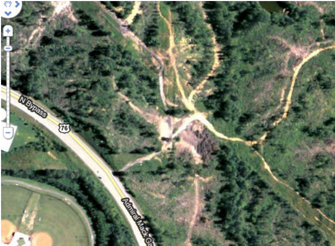
1. Airplane Boneyard 32 08’59.96″ N, 110 50’09.03″W Tucson, Arizona

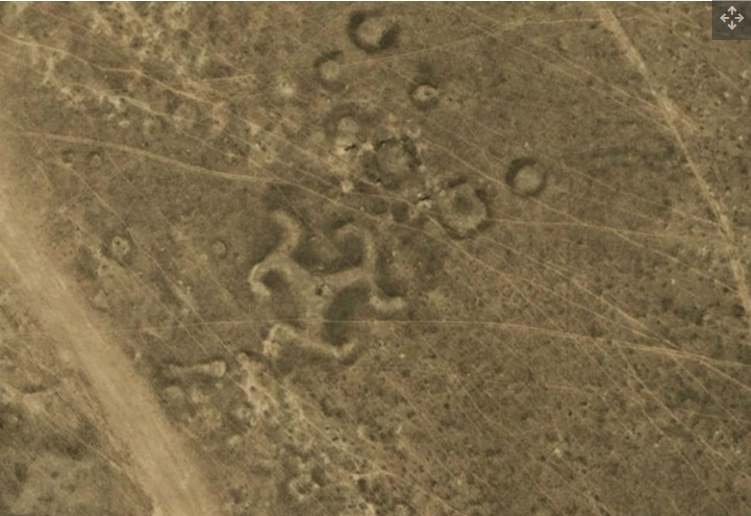
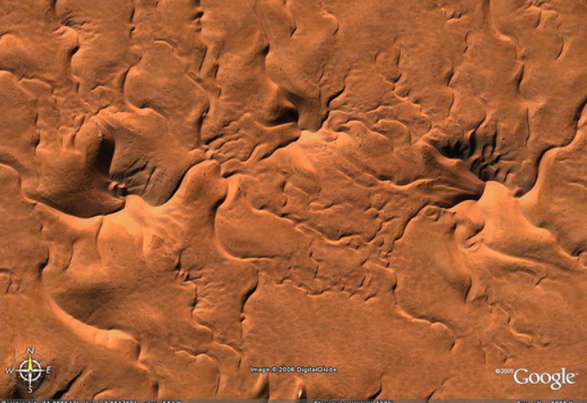
2. Mysterious Desert Pattern 27°22’50.10″N, 33°37’54.62″E Red Sea Governorate, Egypt

3. Swastika-Shaped Building Complex 32°40’34.19″N 117° 9’27.58″W Coronado, California, USA

4. Buffalo Herd 4°17’21.49″ S 31°23’46.46″ E Kigosi Game Reserve, Tanzania

5. Giant Triangle 33.747252, -112.633853 Wittmann, Arizona, USA

6. Shipwrecked SS Ayrfield with Trees -33.836379, 151.080506 Homebush Bay, Sydney, Australia

7. The Badlands Guardian 50° 0’38.20″N 110° 6’48.32″W Walsh, Alberta, Canada

8. Parking Lot for Fighter Jets 33.927911, -118.38069 El Segundo, California, USA

9. Firefox Logo 45° 7’25.87″N 123° 6’48.97″W Dayton, Oregon, USA

10. Guitar-Shaped Forest -33.867886, -63.987 Córdoba, Argentina

11. Heart-Shaped Lake 41.303921, -81.901693 Columbia Station, Ohio, USA

12. Mysterious Desert Pattern 40.452107, 93.742118 China

13. Giant Target 37.563936, -116.85123 Nevada, USA

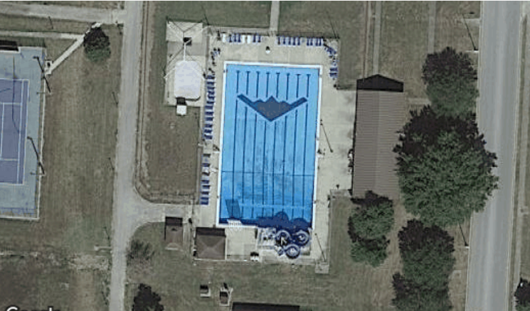
14. World’s Biggest Pool -33.350534, -71.653268 Algarrobo, Valparaíso, Chile

15. Jesus Loves You 43.645074, -115.993081 Boise National Forest, Boise, Idaho, USA

16. Lion King 51.848637, -0.55462 Dunstable LU6 2LD, UK

17. Northern Cyprus Flag 35.282902, 33.376891 Kyrenia, Cyprus

18. Star Fort Schansdijk 5, 4655 De Heen, The Netherlands

19. Potash Ponds 38°29’0.16″N 109°40’52.80″W Moab, Utah, USA

20. Mysterious Pattern 37.629562, -116.849556 Nevada, USA

21. The Whampoa Boat-Shaped Shopping Centre 22°18’14.15″N, 114°11’24.66″E Hung Hom, Kowloon, Hong Kong

22. Russell Square Bloomsbury, London, United Kingdom

23. Coca Cola Logo -18.529211, -70.249941 Arica, Arica y Parinacota, Chile

24. Concentric Cirlces 39.623119, -107.635353 New Castle, Colorado, USA

25. Island in a Lake in an Island in a Lake 69.793° N, 108.241° W Northern Canada

26. Flipped Car 51°19’18.13″N, 6°34’35.64″E Krefeld, Germany

27. Strange Symbol 37.401573, -116.867808 Nevada, USA

28. Monkey Face 65.476721, -173.511416 Russia

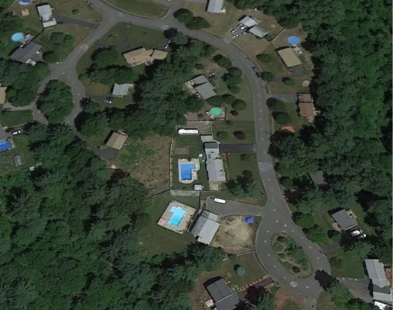
29. Big Swimming Pool 52°29’52.24″N 13°27’13.67″E Berlin, Germany

30. The Shape of this Building 41.84201, -89.485937 Dixon, Illinois, USA

31. Big Friendly Giant 19°56’56.96″S 69°38’1.83″W Huara, Tarapacá, Chile

32. Another Jet in a Parking Lot 48.825183, 2.1985795 92410 Ville-d’Avray, France

33. More Mysterious Desert Patterns 40.458148, 93.393145 China

34. Shipwreck 30.541634, 47.825445 Basrah, Iraq

35. Multiple Landing Strips in the Desert 32.663367, -111.487618 Eloy, Arizona, USA

36. Oil Fields 37°39’16.06″S 68°10’16.42″W Rio Negro, Argentina

37. Mattel Logo 33.921277, -118.391674 El Segundo, California

38. Uluru / Ayers Rock -25.344375, 131.034401 Northern Territory, Austrlia

39. 1:20 Scale Model of Disputed Border Region between India and China 38.265652, 105.9517 Yong Ning Xian, Yinchuan, Ningxia, China

40. UTA Flight 772 Desert Memorial 16.864841, 11.953808 Sahara Desert, southern Ténéré of Niger

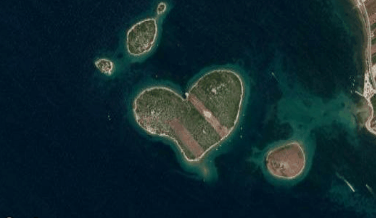
41. Heart-Shaped Land Formation 20°56’15.47″S, 164°39’30.56″E New Caledonia

42. Rainbow Plane Cathy Terrace Englewood Cliffs, New Jersey , USA

43. Barringer Meteor Crater 35.027185, -111.022388 Winslow, Arizona

44. Come Downtown and Play 35.141533, -90.052695 Memphis, Tennessee, USA

45. Hippo Pool 6°53’53.00″ S 31°11’15.40″ E Katavi National Park, Tanzania

46. Solar Field 34.871778, -116.834192 Daggett, California

47. Giant US Flag 7300 Airport Blvd, Houston, TX 77061, USA

48. Big Red Lips in the Desert 12°22’13.32″N, 23°19’20.18″E Sudan

49. Grand Prismatic Spring 44.525049, -110.83819 Yellowstone National Park, Wyoming, USA

50. The Batman Symbol 26.357896, 127.783809 Okinawa, Japan

Make sure to give these a share on Facebook by clicking the button below!
- Share On Facebook
- Odnoklassniki
- Facebook Messenger
- LiveJournal
- 2.1K Shares

Weird Google Earth Destinations You Can Visit From The Comfort Of Your Couch (31 Pics)
I remember when Google Earth was first created. It blew my mind but it was kind of weird to see a picture of my house on the internet.
I went to Hawaii about a year ago for the first time and if I had known how much the world was gonna change in just a few months, I would’ve stayed. People are working from home , Zoom Meetings are the new normal , and who knows when we’ll be able to travel again.
Thanks to Google Earth you can visit anywhere in the world from the comfort of your own couch. We’ve included the coordinates for every weird Google Earth destination we found.
1. Airplane Boneyard — Tucson, Arizona

This is an areal view of the Davis-Monthan Air Force Boneyard in Tucson, Arizona. It began after World War II and it’s the largest military aircraft boneyard in the world.
2. Mysterious Desert Pattern — Red Sea Governorate, Egypt

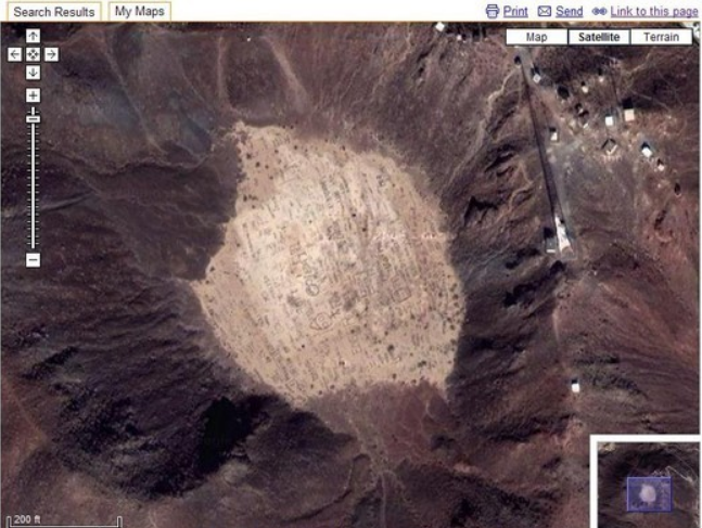
Believe it or not, this isn’t a landing pad for a spaceship but it is a 1 million square foot piece of artwork called — Desert Breath — to celebrate “the desert as a state of mind, a landscape of the mind,” according to the artists’ website .
3. Buffalo Herd — Kigosi Game Reserve, Tanzania

Here, we see a herd of water buffalo at the Kigosi Game Reserve in Tanzania.
4. Giant Triangle — Wittmann, Arizona, USA

According to AZ Central , the “Giant Triangle” was likely used as an airstrip for Luke Air Force Base and part of an airfield that is now used for instrument training by F-16 pilots.
5. Shipwrecked SS Ayrfield with Trees — Homebush Bay, Sydney, Australia

The SS Ayrfield is one of many decommissioned ships in the Homebush Bay, just west of Sydney, but it stands out from others is the incredible “forest” that adorns the rusted hull.
6. The Badlands Guardian — Walsh, Alberta, Canada

The Badlands Guardian is a geomorphological feature located near Medicine Hat in the southeast corner of Alberta, Canada.
7. Jesus Loves You — Boise National Forest, Boise, Idaho, USA

Jesus Love You — each letter is about 31 feet (9.5 meters) long.
8. Guitar-Shaped Forest — Córdoba, Argentina

The guitar forest, planted by farmer Pedro Martin Ureta and his four kids that planted every individual tree decades ago in memory of his wife, Graciela Yraizoz.
9. Heart-Shaped Lake — Columbia Station, Ohio, USA

A heart-shaped lake located in Columbia Station, Ohio.
10. Mysterious Desert Pattern — China

Upon further investigation by Guardian , the mysterious desert pattern appears to be mining, power, and military sites.
11. Giant Target — Nevada, USA

This giant target is likely used for military training. Definitely not aliens…
12. Whipsnade White Lion — Dunstable LU6 2LD, UK

The Whipsnade White Lion was built in 1933. It was designed by Mr. R.B. Brooke-Greaves to indicate the position of Whipsnade wildlife park. The lion is home to a colony of cavies and wallabies which can be seen occasionally on the lion.
13. Northern Cyprus Flag. — Kyrenia, Cyprus

A painting of the Northern Cyprus flag on a mountain near Nicosia/Cyprus.
14. Potash Ponds — Moab, Utah, USA

According to Atlas Obscura , the Moab potash mine and evaporation ponds are located about 10 miles southwest of Moab in southeastern Utah. They are also located in between Arches National Park to the north and Canyonlands National Park to the southwest.
15. Mysterious Pattern — Nevada, USA

This is another formation likely a part of an airfield that is now used for instrument training by F-16 pilots in Nevada.
16. Coca Cola Logo — Arica, Arica y Parinacota, Chile

According to Atlas Obscura , created to commemorate Coke’s 100th anniversary, the logo is a simple one – that classic Coca-Cola script with a caption beneath it that originally read “100 años” – 100 years.
17. Island in a Lake in an Island in a Lake — Northern Canada

The only island in a lake on an “island in a lake on an island” located in Northern Canada. I didn’t even know this was a thing but it’s pretty cool.
18. Strange Symbol — Nevada, USA

This is also another likely symbol used for military training in Nevada. Plenty of space in the desert!
19. Monkey Face — Russia

This is a formation that looks like a monkey’s face located in Russia.
20. The Most Phallic Building — Dixon, Illinois, USA

Believe it or not, this penis-shaped building is a church.
21. Mattel Logo — El Segundo, California

The Matell headquarters in el Segundo, CA has a logo installation that is visible from space.
22. oil fields — rio negro, argentina.

These bizarre lines are actually an oil field in Río Negro Province, Argentina.
23. Uluru / Ayers Rock — Northern Territory, Australia

Uluru, or Ayers Rock, is a massive sandstone monolith in the heart of the Northern Territory’s arid “Red Centre”.
24. 1:20 Scale Model of Disputed Border Region between India and China — Yong Ning Xian, Yinchuan, Ningxia, China

This scale model represents – a region occupied by China but claimed by India near north-central India.
25. UTA Flight 772 Desert Memorial — Sahara Desert, southern Ténéré of Niger

A memorial for UTA Flight 772 which crashed in the Sahara Desert on September 19, 1989.
26. heart-shaped land formation — new caledonia.

The Heart of Voh is a natural clearing formed by the mangroves.
27. Barringer Meteor Crater — Winslow, Arizona

An areal view of the Barringer Meteor Crater — Winslow, Arizona created about 50,000 years ago during the Pleistocene epoch. (I’ve actually been here!)
28. Hippo Pool — Katavi National Park, Tanzania

A play park for hundreds of hippos year-round, it offers a constant water supply from the converging Seronera and Orangi rivers in the Serengeti National Park.
29. Big Red Lips in the Desert — Sudan

A cool land formation in the Sudan. Likely different colored sand that looks like a pair of red lips from above.
30. Grand Prismatic Spring — Yellowstone National Park, Wyoming, USA

An areal view of the Grand Prismatic Spring at Yellowstone National Park, in Wyoming.
31. Batman Symbol — Okinawa, Japan

A batman symbol on the roof of a building in Okinawa, Japan.
More Cool Pics:
- 21 Times People Asked The Internet “What Is This Thing?” And The Internet Delivered
- This Is 2020 Broken Down By Trending Google Searches
- Museums Duel Over Who Has The Coolest Artifact In Their Collection (30 Pics)
- Travel Fails To Remind You Staying Home Isn’t Always So Bad (27 Pics)
- If You’re Going To Be One Of Those Couples That Gets Matching Tattoos, At Least Make Them Cool (34 Pics)
Nate Armbruster
Nate Armbruster is a stand-up comedian and writer based in Chicago who is likely writing a joke as you read this. Find him online at natecomedy.com.

50 unusual finds on Google Earth
Strange and amazing satellite photos, 2. mysterious drawing in the desert (27°22'50.10″n, 33°37'54.62″e) governorate of the red sea, egypt, 3. building in the shape of a swastika cross (32°40'34.19″n 117° 9'27.58″w) coronado, california, usa, 4. bison herd (4°17'21.49″ s 31°23'46.46″ e) kigosi reserve, tanzania, 5. giant triangle (33.747252, -112.633853) wittmann, arizona, usa, 6. the ss ayrfield wreck with trees (-33.836379, 151.080506), homebush bay, sydney, australia, 7. the badlands guardian (50° 0'38.20″n 110° 6'48.32″w) walsh, canada, 8. a parking lot for fighter planes (33.927911, -118.38069) el segundo, california, usa, 9. firefox logo (45° 7'25.87″n 123° 6'48.97″w) dayton, oregon, usa, 10. guitar-shaped forest (-33.867886, -63.987) córdoba, argentina, 11. heart-shaped lake (41.303921, -81.901693) columbia station, ohio, usa, 12. mysterious motive in the desert (40.452107, 93.742118) china, 13. giant target (37.563936, -116.85123) nevada, usa, 14. world's largest swimming pool (-33.350534, -71.653268) algarrobo, chile, 15. "jesus loves you" (43.645074, -115.993081) boise national forest, usa, 16. the lion king (51.848637, -0.55462) dunstable, united kingdom, 17. giant flag of northern cyprus (35.282902, 33.376891) kyrenia, cyprus, 18. star-shaped fort henricus (schansdijk 5, 4655 de heen) netherlands, 19. potash ponds (intrepid potash) (38°29'0.16″n 109°40'52.80″w) moab, utah, usa, 20. mysterious drawing (37.629562, -116.849556) nevada, usa, 21. boat-shaped whampoa shopping centre (22°18'14.15″n, 114°11'24.66″e) hong kong, 22. russell square, bloomsbury, london, 23. coca cola logo (-18.529211, -70.249941) arica and parinacota region, chile, 24. concentric circles (39.623119, -107.635353) new castle, colorado, usa, 25. an island in a lake on an island in a lake (69.793° n, 108.241° w) northern canada, 26. one car returned (51°19'18.13″n, 6°34'35.64″e) krefeld, germany, 27. a strange symbol (37.401573, -116.867808) nevada, usa, 28. one monkey face (65.476721, -173.511416) russia, 29. the badeschiff (52°29'52.24″n 13°27'13.67″e) berlin, germany, 30. a building with an odd shape... (41.84201, -89.485937) dixon, illinois, usa, 31. the atacama giant (19°56'56.96″s 69°38'1.83″w) huara, tarapacá, chile, 32. another fighter plane on a parking lot (48.825183, 2.1985795) ville-d'avray, france, 33. another strange drawing in the desert (40.458148, 93.393145) china, 34. a wreck (30.541634, 47.825445) basra, iraq, 35. airstrips in the desert (32.663367, -111.487618) eloy, arizona, usa, 36. oil fields (37°39'16.06″s 68°10'16.42″w) province of río negro, argentina, 37. mattel logo (33.921277, -118.391674) el segundo, california, usa, 38. uluru / ayers rock (-25.344375, 131.034401) australia, 39. scaled-down model of the disputed border region between india and china (38.265652, 105.9517), 40 memorial of flight 772 awu (16.864841, 11.953808) ténéré desert, niger, 41. a natural heart shape (20°56'15.47″s, 164°39'30.56″e) new caledonia, 42. rainbow plane, new jersey, usa., 43. barringer meteor crater (35.027185, -111.022388) winslow, arizona, usa, 44. "come downtown and play (35.141533, -90.052695) memphis, tennessee, usa, 45. a hippopotamus bath (6°53'53.00″ s 31°11'15.40″ e) katavi national park, tanzania, 46. solar project (34.871778, -116.834192) daggett, california, usa, 47. giant united states flag (7300 airport blvd, houston, tx 77061, usa), 48. big red lips in the desert (12°22'13.32″n, 23°19'20.18″e) sudan, 49. grand prismatic spring (44.525049, -110.83819) yellowstone national park, usa, 50. sign of batman (26.357896, 127.783809) okinawa, japan.
Google Earth is a tool that allows you to explore the entire Earth without moving from home. This ingenious program juxtaposes billions of satellite images to recreate a cartography of the globe. And like their program Google Maps and Google Street View, there are many curiosities ...
You've probably already spotted some of them, but the pictures below will show you other oddities that can only be seen from the sky. From natural formations to man-made structures, we found 50 strange places photographed by the web giant Google.
If you're interested in checking out these places yourself, the GPS coordinates of each image are shown. Just copy and paste them into Google Earth (or Google Maps) to study them in more detail.
All images are screenshots from Google Earth.
1. Aircraft Cemetery (32 08'59.96″ N, 110 50'09.03″W) Tucson, Arizona

Related Items

add a comment of 50 unusual finds on Google Earth
Content for you.

TwistedSifter
The best of the visual web, sifted, sorted and summarized.
- ARCHITECTURE
- NATURE/SPACE
- SHIRK REPORT
- INFORMATIVE
50 Amazing Finds on Google Earth
by twistedsifter
Google Earth is a virtual globe, map and geographical information program. It maps the Earth by the superimposition of images obtained from satellite imagery, aerial photography and geographic information system (GIS) 3D globe. Just like their data-rich Maps and Street View offerings, Google Earth is a treasure trove of oddities.
You’ve no doubt already come across some interesting finds on Google Earth. The post below attempts to compile the most fascinating sites other have stumbled upon browsing Google Earth. From natural formations to human structures, the world is a different place when viewed from above.
If you’re interested in seeing any of the places yourself, I’ve included the coordinates for every image shown below. Just copy and paste into Google Earth/Maps and explore for yourself!
1. Airplane Boneyard 32 08’59.96″ N, 110 50’09.03″W Tucson, Arizona

2. Mysterious Desert Pattern 27°22’50.10″N, 33°37’54.62″E Red Sea Governorate, Egypt

*Update* This is a land art project called Desert Breath by the D.A.ST. Arteam. The Sifter did an entire post on the piece here .
3. Swastika-Shaped Building Complex 32°40’34.19″N 117° 9’27.58″W Coronado, California, USA

4. Buffalo Herd 4°17’21.49″ S 31°23’46.46″ E Kigosi Game Reserve, Tanzania

5. Giant Triangle 33.747252, -112.633853 Wittmann, Arizona, USA

6. Shipwrecked SS Ayrfield with Trees -33.836379, 151.080506 Homebush Bay, Sydney, Australia

7. The Badlands Guardian 50° 0’38.20″N 110° 6’48.32″W Walsh, Alberta, Canada

8. Parking Lot for Fighter Jets 33.927911, -118.38069 El Segundo, California, USA

9. Firefox Logo 45° 7’25.87″N 123° 6’48.97″W Dayton, Oregon, USA
10. Guitar-Shaped Forest -33.867886, -63.987 Córdoba, Argentina

Located in the fertile agricultural region of Argentina’s ‘Pampas’ is a guitar-shaped forest made up of over 7,000 cypress and eucalyptus trees. A farmer named Pedro Martin Ureta planted the forest in memory of his wife. You can read about the touching story here .
11. Heart-Shaped Lake 41.303921, -81.901693 Columbia Station, Ohio, USA

12. Mysterious Desert Pattern 40.452107, 93.742118 China

13. Giant Target 37.563936, -116.85123 Nevada, USA

*Update* The Sifter did an entire post on strange markings in the USA. Some are ‘eye charts’ for airplanes, better known as aerial photo calibration targets . The Sifter did an entire post on them here .
14. World’s Biggest Pool -33.350534, -71.653268 Algarrobo, Valparaíso, Chile

At 1,013 meters (3,324 ft) in length with a total area of 8 hectares (19.77 acres), the swimming pool at the San Alfonso del Mar resort in Algarrobo, Chile is the largest in the world. You can read all about it here .
15. Jesus Loves You 43.645074, -115.993081 Boise National Forest, Boise, Idaho, USA

16. Lion King 51.848637, -0.55462 Dunstable LU6 2LD, UK

17. Northern Cyprus Flag 35.282902, 33.376891 Kyrenia, Cyprus

18. Star Fort Schansdijk 5, 4655 De Heen, The Netherlands

19. Potash Ponds 38°29’0.16″N 109°40’52.80″W Moab, Utah, USA

20. Mysterious Pattern 37.629562, -116.849556 Nevada, USA

21. The Whampoa Boat-Shaped Shopping Centre 22°18’14.15″N, 114°11’24.66″E Hung Hom, Kowloon, Hong Kong

22. Russell Square Bloomsbury, London, United Kingdom

23. Coca Cola Logo -18.529211, -70.249941 Arica, Arica y Parinacota, Chile

24. Concentric Cirlces 39.623119, -107.635353 New Castle, Colorado, USA

25. Island in a Lake in an Island in a Lake 69.793° N, 108.241° W Northern Canada

26. Flipped Car 51°19’18.13″N, 6°34’35.64″E Krefeld, Germany

27. Strange Symbol 37.401573, -116.867808 Nevada, USA

28. Monkey Face 65.476721, -173.511416 Russia

29. Big Swimming Pool 52°29’52.24″N 13°27’13.67″E Berlin, Germany

30. A Most Phallic Buliding 41.84201, -89.485937 Dixon, Illinois, USA

31. Big Friendly Giant 19°56’56.96″S 69°38’1.83″W Huara, Tarapacá, Chile

32. Another Jet in a Parking Lot 48.825183, 2.1985795 92410 Ville-d’Avray, France

33. More Mysterious Desert Patterns 40.458148, 93.393145 China

34. Shipwreck 30.541634, 47.825445 Basrah, Iraq

35. Multiple Landing Strips in the Desert 32.663367, -111.487618 Eloy, Arizona, USA

36. Oil Fields 37°39’16.06″S 68°10’16.42″W Rio Negro, Argentina

37. Mattel Logo 33.921277, -118.391674 El Segundo, California
38. Uluru / Ayers Rock -25.344375, 131.034401 Northern Territory, Austrlia

39. 1:20 Scale Model of Disputed Border Region between India and China 38.265652, 105.9517 Yong Ning Xian, Yinchuan, Ningxia, China

40. UTA Flight 772 Desert Memorial 16.864841, 11.953808 Sahara Desert, southern Ténéré of Niger

41. Heart-Shaped Land Formation 20°56’15.47″S, 164°39’30.56″E New Caledonia

42. Rainbow Plane Cathy Terrace Englewood Cliffs, New Jersey , USA

43. Barringer Meteor Crater 35.027185, -111.022388 Winslow, Arizona

44. Come Downtown and Play 35.141533, -90.052695 Memphis, Tennessee, USA

45. Hippo Pool 6°53’53.00″ S 31°11’15.40″ E Katavi National Park, Tanzania

46. Solar Field 34.871778, -116.834192 Daggett, California

47. Giant US Flag 7300 Airport Blvd, Houston, TX 77061, USA

48. Big Red Lips in the Desert 12°22’13.32″N, 23°19’20.18″E Sudan

49. Grand Prismatic Spring 44.525049, -110.83819 Yellowstone National Park, Wyoming, USA

50. Batman Symbol 26.357896, 127.783809 Okinawa, Japan

– Google Earth – Weird Google Earth – Strangest Sights in Google Earth, Part II – Why Is China Building These Gigantic Structures In the Middle of Nowhere? – The Google Earth Secret Coordinates – MASTER COLLECTION
If you enjoyed this post, the Sifter highly recommends:

Categories: ANIMALS , ARCHITECTURE , BEST OF , LISTS , NATURE/SPACE , STORIES , TRAVEL Tags: · aerial , google , maps , satellite , world tour

Sign up to get our BEST stories of the week straight to your inbox.
- PRIVACY POLICY
- Write For Us
- AFFILIATE DISCLOSURE
Neglected Son Finally Told His Father How His Cold Parenting Affected Him, But Now He Wonders Whether He Was Too Harsh About It

Camp Counselor Keeps Making The Same Joke About The Cooking, So The Camp Chef Mustards Up An Unforgettable Rebuttal

Twin Sister Wasn’t Worried About Waking Up The Rest Of The Household, But Now Her Brother Plans To Give Her A Taste Of Her Own Medicine

Stranger In And Elevator Had His Phone On Speaker, So They Got Revenge By Turning Up The Volume On Their Music

Elderly Couple Had Their Home Foreclosed Upon, So They Left A Smelly Surprise For The Bank And Got Their Home Back

Some Hikers Were Crossing His Property And Wanted Him To Fill Their Water Bottles For Free, But He Insisted That They Pay Or Go Visit The Creek One Hour Away

New Neighbor Moves In And Starts Parking In Their Driveway And Cutting Down Their Trees, So They Got Friends Together To Build A Fence To Send A Clear Message To Stay Out

The House Next Door Was Purchased By A Developer And Bulldozed To Make Room For A Much Larger Home, But It Blocks Most Of The Sun To The Neighbor’s Garden. Now He’s Giving The New Homeowners The Silent Treatment.

He Used To Let The Neighborhood Kids Play Football On His Property, But Then The New Neighbors Moved In And Ruined It For Everyone

Copyright © 2024 · All Rights Reserved · TwistedSifter
Powered by WordPress VIP · RSS Feed · Log in
- 14 Cool Places to Explore on Google Earth

The view from far above grants us an entirely different outlook on the Earth's features. Google Earth offers a safe peek at the sites of mysterious disappearances, nuclear disasters, unapproachable or distant locations, secret government bases, diamond mines, and even the outlines of the past crater strikes. The unique perspective offered by the satellite imaging has inspired artists (and, possibly, aliens) to create new landmarks that could never be appreciated from any other angle.
Desert Breath Pattern Art

27.380583, 33.631839
Red Sea Governorate, Egypt
Located in a desolate Egyptian desert, not far from the shores of the Red Sea, this 1 million square foot spiral design is, in fact, an art project called Desert Breath. In March 2007, Danae Stratou, Alexandra Stratou, and Stella Constantinides created this artwork meant to celebrate the desert landscape. Since the first pictures you can find on their site, the grand art has significantly eroded and no longer looks quite as prominent.
The Badlands Guardian

50.010611, -110.113422
Walsh, Alberta, Canada
The Badlands Guardian is a geomorphological feature situated in the southeast corner of Alberta, Canada. Viewed from the air, it resembles a westward-facing human head wearing a full Indigenous headdress. This area has been traditionally the home of the Siska First Nation, also known as the Blackfoot tribes. The location of the geological feature is very remote and not readily accessible: the Badlands is a deserted and often unfriendly terrain of ravines, hills, and sinkholes. The Earth folds shaping the contour of a giant were formed by the end of the last Ice Age when melting glaciers dissolved clays and light sedimentary soils. These landscapes keep changing even these days, being carved and eroded under the pressure of the wind and heavy rains, forming unique geomorphic features and intriguing topographies.
Airplane Boneyard

32.149989, -110.835842
Tucson, Arizona
The Davis Monthan Air Force Base is where US military planes go to retire. Named "the boneyard," this 4 square mile cemetery of skyborne steel is not accessible for the general public. Still, Google Earth provides a convenient curiosity tour: practically every plane the military has used since World War II, from the B-52 Stratofortress to the F-14 Tomcat. The airplanes from different times have various degrees of decay. Did you know that a retired airplane can make for an innovative and extravagant house? There have been several architectural projects repurposing elements or even entire retired planes as homes.
Guitar-Shaped Forest

-33.867886, -63.987
Córdoba, Argentina
This 2/3 mile long guitar forest was nurtured in the fertile agricultural region of Argentina's pampas. At this size and on the backdrop of plain cultured fields, the guitar-shaped forest is noticeable from both planes and satellites. The guitar forest is a creation of a local farmer Pedro Martin Ureta and his four kids: that planted every tree by hand decades ago. The guitar-shaped forest was intended as a memorial for Pedro's wife, Graciela Yraizoz, who died of an aneurism in 1977. A couple of years later, Pedro remembered his wife's idea to shape the farm after her favorite instrument and decided to honor her memory. With the help of their children, he planted and nurtured roughly 7,000 cypress and eucalyptus trees.
Networked Oil Fields

-37.654461, -68.171228
Rio Negro, Argentina
Not much to be said: it is an oil field being actively developed by YPF. But quite a beautiful sight from above, looking like an elaborate network of nodes and lines.
The White Lion

51.848637, -0.55462
Dunstable LU6 2LD, UK
Coined by some as a "Lion King," this geoglyph, known initially as Whipsnade White Lion, was built in 1933 for an unusual reason. The colossal feline was dug into a chalk hill within the Dunstable downs near the Whipsnade Zoo. Initially, only the outline of the lion could be seen, but it was eventually completed to become the largest geoglyph in the country. The Zoological Society of London conceived the lion project as a landmark to warn passing pilots not to fly low over the zoo to avoid scaring animals. The second purpose of the zoo carving was, of course, advertising for the zoo. Over the years, the lion deteriorated and became overgrown; luckily, in March of 2018, a neighbor donated 50 truckloads of chalk so the zoo could make the lion shine white again.
Electric Blue Potash Mine Bonds

38.483378, -109.681333
Moab, Utah, USA
These ponds are maintained to extract potassium chloride, also known as potash, from the desert landscapes of Utah. Potash is mainly required in the production of potent fertilizers. Most potash forms in areas when inland seas or lakes dry out: as their waters evaporated, they left behind potassium salt deposits. Why does the water have such an unusually vibrant color? The water is dyed bright blue purposely to help it absorb more sunlight and heat and decrease the time it takes for the water to evaporate. As it happens, potash and other salts crystallize out. The evaporation process takes approximately 300 days. At the different stages of evaporation, the ponds can take different colors. Most of the "new" ponds are a bright electric blue. As time passes, ponds display different stages of evaporation as an array of colors, from various hues of blue and turquoise to orange, yellow, and white.
Groom Lake Base, known as Area 51

37.242457, -115.815044
Nevada, USA
Until recently, satellite imagery of this US Air Force military installation was censored. Area 51 became visible on Google Maps only since 2018. But is it the real image or just a cover-up? Who would tell? Area 51 is an active military installation: it is not accessible to the public and is under 24-hour surveillance. Area 51 employees reach the facility by air. They fly in and out via a restricted terminal at McCarran International Airport on one of several unmarked planes allowed to fly through the airspace R-4808N above Area 51. The only officially confirmed use of the base is as a flight-testing facility. Since the 50s, the base was used to develop and test the most advanced aircraft, including stealth and various other innovative technologies. In 1989, Robert Lazar claimed that Area 51 discovered an extraterrestrial technology. Lazar told the reporters that the US government used the facility to examine an alien spacecraft and the remains of an alien pilot; his story was since discredited, but Area 51 remains a symbolic name for every extraterrestrial enthusiast.
Bermuda Triangle

25.001283, -71.000000
Atlantic Ocean
The Bermuda Triangle, an expanse of the ocean known as a Devil's Triangle or Hurricane Alley, is located in the western part of the North Atlantic Ocean. Several aircraft and ships are said to have disappeared under mysterious circumstances or succumbed to an unknown danger. One of the most famous stories happened in 1945: five Navy planes set off from Fort Lauderdale, Florida, in order to conduct training bombing over some nearby shoals. The leading aircraft of the group, known as Flight 19, got helplessly lost; apparently, due to his compass malfunction. All five bombers kept circling aimlessly until they ran low on fuel and were forced to drop into the sea. A rescue plane with its 13-man crew disappeared the same day.
Atacama Giant

-19.949156, -69.633842
Atacama Desert, Chile
The Atacama Giant is an anthropomorphic geoglyph on Cerro Unitas in the Atacama Desert, Chile. It is the largest anthropomorphic figure in the world dated at prehistoric times, from AD 1000 to 1400. It appears to represent a deity; there is also a hypothesis suggesting that the figure was an early astronomical for observing and marking the moon movement; by knowing where the Moon sat, the day and the season could be determined with the precision required for the effective crop cycle. The landscape of Atacama is incredibly rich in unique geoglyphs: nearly 5,000 of these ancient artworks have been discovered to date.
Former Solar Field (now A Lot Of Circles)

34.871778, -116.834192
Daggett, California
The SOLAR Project is, in fact, three consecutive experiments: Solar One, Solar Two, and Solar Tres. They are (now former) solar thermal power plants based in the Mojave Desert, United States, and Andalucía, Spain (the Tres one). Solar One and Solar Two have been discarded since 2009. Solar One was a pilot solar-thermal project: the first test of a large-scale thermal solar power tower plant. In 1995, Solar One was upgraded to become Solar Two: the second ring of 108 larger heliostats was added, totaling 1926. The upgrade gave Solar Two the ability to produce 10 megawatts: enough to power an estimated 7,500 homes. Solar Two was decommissioned in 1999, but the project was considered a success, so the Solar Tres was built in Spain.
Batman Symbol

26.357896, 127.783809
Okinawa, Japan
Batman symbol in Okinawa Japan is real. The iconic white bat marks the home of the Air Force's 44th Fighter Squadron, which is known as the Vampire Bats, according to Kadena spokesman Ed Gulick, but it was unclear who painted it on the roof. It was believed to have been done in the 1980s. A similar painting of a fighting cock can is drawn on the roof of a Kadena building used by the 67th Fighter Squadron.

45.019120, -76.898557
North Frontenac, Canadá
There are over 30 famous heart-shaped lakes that can be seen all over the world. This particular one has especially charming features: not only its shape is natural yet almost perfect, but it can be seen in a variety of colors depending on the season. If you visit Google Maps right now (at the moment of writing this article, it is January) you will see it in white, in a dark green rapport of trees. In autumn, it appears deep blue in the golden ornament of the fall leaves. The lake is surrounded by the Heart Lake Conservation Area in which trees are planted every year by students from the local elementary schools.
Island in a Lake in an Island in a Lake
69.793000, -108.241000

Northern Canada
The world's largest island-in-a-lake-on-an-island-in-a-lake-on-an-island is a small piece of land in Canada. The nameless island lays across the center of a small lake, which is itself encapsulated by a slightly larger island. That resides inside one of a few long elliptical lakes located 75 miles southward from the coast of Victoria Island. In all likelihood, no human has ever stepped on that island.
Do not forget to check out the second part of this collection here!
More in Travel

An Eco Tour Through Florida's Nature Coast

Visiting Alberta’s Top Dinosaur Hotspots

An Unforgettable Summer In Calgary

Scalloping and Offshore Adventure in Steinhatchee, Florida

Orlando Beyond the Theme Parks

A Journey Through Canada's Underrated Grasslands National Park

Day Tripping Around Atlantic Beach

Visiting Old Friends in the UK
🙌 Awesome, you're subscribed!
Thanks for subscribing! Look out for your first newsletter in your inbox soon!
Get us in your inbox
Sign up to our newsletter for the latest and greatest from your city and beyond
By entering your email address you agree to our Terms of Use and Privacy Policy and consent to receive emails from Time Out about news, events, offers and partner promotions.
Awesome, you're subscribed!
The best things in life are free.
Sign up for our email to enjoy your city without spending a thing (as well as some options when you’re feeling flush).
Déjà vu! We already have this email. Try another?
Love the mag?
Our newsletter hand-delivers the best bits to your inbox. Sign up to unlock our digital magazines and also receive the latest news, events, offers and partner promotions.
- Things to Do
- Food & Drink
- Arts & Culture
- Time Out Market
- Coca-Cola Foodmarks
- Los Angeles

The 23 weirdest places on earth you have to visit at least once
Rainbow-coloured mountains, red beaches and ‘cotton castles’, these destinations are certainly one for the bucket list.

Louis Armstrong certainly got it right: we really do live in a wonderful world. From the mountains of China to the coasts of Ireland , each corner of this glorious planet is steeped in (almost) other-worldly wonders.
Some exist almost beyond comprehension. Beaches aren’t supposed to be red, nor are lakes supposed to be pink, but we suppose that’s the beauty of this planet. The earth’s environments give us life and look darn good doing it, too. Keen to see what all the fuss is about? Here are our top picks for the weirdest places in the world, that you’ve absolutely got to pay a visit.
RECOMMENDED: 🌃The best things to do in the world this year 🌟The best places in the world for stargazing 🏖️The best beaches in the world 🌍The best places in the world to travel alone
For more about how we curate, see our editorial guidelines and check out our latest travel guides written by local experts.
Been there, done that? Think again, my friend.
The weirdest places in the world
1. jervis bay, australia.

Australia ’s Jervis Bay is actually home to the whitest sandy beach on the planet, but visitors don’t flock here for whiter-than-white sand. Okay, some do, but most head to this 102-square-kilometre oceanic bay for the magic that comes after dark. Jervis Bay is one of the few places on the planet where people can see the wonder of bioluminescence, as masses of plankton glow in the dark and give the water a gorgeously ethereal look. These are noctiluca, or maybe the more apt ‘sea sparkle’, and the light is a chemical reaction causing excitement and vibration, generating the glow in the process. Bioluminescence is most often seen in the warmer months, but you can get lucky at all times of the year in Jervis Bay.
2. Spotted Lake, Canada

Hidden away in British Columbia, Canada ’s Spotted Lake (known to First Nations people as Kliluk ) is straight out of science fiction. This small body of water is packed with different minerals, from masses of calcium and sodium sulphates to small amounts of silver and titanium. When the water evaporates in summer, a weird collection of deposits is left behind, giving the Spotted Lake its moniker. You can actually walk around the deposits in summer, although good luck shaking the feeling that something might jump out at any moment…
3. Danakil Depression, Ethiopia

If aliens exist on Earth, they exist here. The Danakil Depression in Ethiopia is a weirder-than-weird piece of wonder that is the result of three tectonic plates diverging and leaving behind lava lakes, acidic springs and more. It is known as the ‘hottest place on the planet’, and that is no joke. Geothermal activity in summer causes temperates to reach as high as 55 degrees celsius.
4. Zhangye Danxia, China

It's easy to convince yourself that the swirling colours of China ’s Zhangye Danxia mountains are actually a painting, but this gorgeous landscape is very, very real. The colours are thanks to the whimsical movements of mineral deposits over millennia, although it took just about that much time for China to pay much attention to it. Several observation decks offer visitors stunning views without damaging the landscape, which is good news for everyone.
5. Giant’s Causeway, Northern Ireland

According to legend, the Giant’s Causeway in Northern Ireland dates back to the time of Fionn Mac Cumhaill, a giant tasked with defending his land from the fearsome Benandonner. The story goes that Fionn decided to take the challenge head on, and built this causeway as a way to approach his foe, although the story goes off in many directions from there. Whatever its origins, the sight of some 40,000 basalt columns jutting out into the North Atlantic Ocean is one of the most unique images around, backed by imposing hills and the quietly seething sea.
6. Lake Hillier, Australia

We wouldn’t ever claim to be expert limnologists, but we know enough about lakes to know that they aren’t usually pink. Not pink of any shade, let alone bright bubblegum pink, but that is the hue of Lake Hillier, a saline lake found on the edges of Middle Island in Western Australia. Algae, halobacteria and other microbes create this incredible scene, one that would be safe to swim in if you could actually go in the water. It isn’t the easiest to get to, though, with scenic flights pretty much the best option.
7. Tianzi Mountains, China

Not your ordinary mountain peaks, that’s for sure. The peaks of the Tianzi Mountains are China look as if they were designed by a writer of dystopian fiction, straight out of a post-apocalyptic planet where survival is the only ambition. That may sound very dramatic, but the drama is inspired in heavy doses by these stunners, found in Zhangjiajie in Hunan Province. The mountains are easily accessible from Zhangjiajie, although you really need to be a bird to see the full picture.
8. Green Bridge of Wales

Natural arches are weird wherever they are, be it the mountains of Bosnia and Herzegovina or the massive arch found in Arches National Park, Utah . There is something beautifully fragile about the Green Bridge of Wales , however, and it’s accentuated by the sleepy serenity of the Pembrokeshire coast and that inimitable sense of poetry that flows out of this small nation. The arch is located in the Castlemartin military area, so be sure to call ahead and make sure you can actually get to the thing.
9. Darvaza Gas Crater, Turkmenistan

If you’ve always wanted to visit the Gates of Hell, you better get your skates on. Not the actual gates of hell, that will have to wait for the afterlife, but Turkmenistan is planning on closing its Darvaza gas crater soon. The crater has been burning for decades, creating one of the most intense images on the planet, and visitors have flocked here for the sort of view that just shouldn’t be possible. Nobody really knows how it ignited, but we can only assume it had something to do with Beelzebub.
10. Rainbow River, Colombia

The name is something of a giveaway. Okay, the official name is Caño Cristales, but Colombia ’s Rainbow River is an incredible celebration of colour that must be seen to be believed. Red, yellow, purple and greens abound in this liquid rainbow, flowing dramatically through the Serranía de la Macarena National Park, with the colours changing depending on light conditions. Red dominates, thanks to the Macarenia clavigera plants on the river’s bed, and the many waterfalls accentuate what is already an incredible sight.
11. Vinicunca, Peru

Sticking with rainbows and South America, Peru ’s Rainbow Mountain is straight out of a psychedelic dream. Vinicunca’s unique multi-coloured marble look is the result of sedimentary deposits over the centuries, and the whole thing makes for a truly remarkable hike. It takes around four hours to scale the mountain, depending on how often you stop to marvel at how you’re actually climbing a rainbow mountain.
12. Chocolate Hills, Philippines

Unfortunately, these natural wonders aren’t literally made out of chocolate, they are simply covered in grass that turns brown during the dry season. Found in the Bohol province of the Philippines , the Chocolate Hills are among the most popular tourist attractions in the country and are undoubtedly its weirdest. Nobody really knows how many chocolate hills there actually are, with most estimates in the 1,800 range. That doesn’t really matter though – only chocolate does.
13. Lunar Rainbow, Victoria Falls, Zambia

A moonbow! No, it isn’t the fantastical creation of a children’s fiction writer, but a very real phenomenon found at the already-magnificent Victoria Falls in southern Africa . These nighttime rainbows are only visible when there is a considerable amount of spray splashing back from the powerful cascades, so don’t bother heading here during the dry season in hopes of a miracle. The rainbow happens when light from the moon interacts with all the spray, and the results are magical.
14. Thor’s Well, USA

Some people refer to Thor’s Well as the ‘Drainpipe of the Pacific’, but that just sounds downright disgusting. We’ll stick to Thor’s Well, a thrilling sinkhole that seems to suck the power of the ocean into its grasp at will. It is something of an oceanic black hole, so don’t expect to be able to go for a dip in it, lest you be sucked into the underworld for all eternity. This rough basalt hole is a few miles south of Yachats in the Cape Perpetua Scenic Area, Oregon .
15. Champagne Pool, New Zealand

We aren’t entirely sure if swimming in champagne sounds fantastic or just really, really sticky, but New Zealand ’s Champagne Pool well and truly deserves its spot on our collection of weird and wonderful places around the world. This fascinating pool (some 30km southeast of Rotorua) isn’t actually filled with champagne, but it gets the name from the constant flow of carbon dioxide gas, giving it a bubbling characteristic similar to that oh-so-luxurious beverage.
16. Pamukkale, Turkey

Pamukkale literally translates as ‘cotton castle’, and that feels like a particularly apt name for this incredible network of thermal waters found in the west of Turkey . The geothermal phenomenon has been attracting visitors looking for revitalisation for centuries, but it took designation as a Unesco World Heritage site for the area to be maintained and preserved. The nearby Hierapolis ruins can be underwhelming, but the Cotton Castle never fails to delight.
17. Sand Pyramids, Bosnia and Herzegovina

Sand pyramids are weird. They crop up here and there across the world, but the small collection of sand structures found just outside Foča (Bosnia and Herzegovina) are the only ones in the world that are still growing to this very day. What does that mean? It’ll take many a year before we find out, so make a beeline for this beautiful part of the world for some tranquil observation.
18. Red Beach, China

What an incredible image this is. China’s Red Beach (found in Panjin) looks like something straight out of a heavily-edited movie, as deep crimson takes the place of colours we’ve come to expect in marshes. The Red Beach forms part of the biggest wetland on the planet (itself pretty darn weird), and the colour comes from the Suaeda salsa plant, one of the few species that have what it takes to survive in highly alkaline soil. Don’t worry about the science, just focus on how darn beautiful it is.
19. Fly Geyser, USA

Nothing to see here, just a vivid six-foot geyser spitting water into the air at all times in the middle of the Nevada desert. It has been described as an accidental wonder, but nothing this marvellous can be an accident, so we’re chalking the Fly Geyser up to the ingenious creativity of whoever created this world. The only way to visit it is via a private tour with the Friends of Nevada Black Rock High Rock.
20. Uyuni Salt Flat, Bolivia

Human beings couldn’t survive without salt. The most important of all seasonings is responsible for a heck of a lot more than people realise, so there’s an extra special joy to the Uyuni Salt Flat. Of course, nobody really comes here to ponder the importance of salt. They come to see something truly incredible: nearly 11,000 square kilometres of flat land that is simultaneously otherworldly and very much of this place.
21. Badab-e-Surt, Iran

A preposterous amount of iron oxide has come together at this natural wonder in Iran’s Mazandaran province, giving Badab-e-Surt a distinctive orange glow that is straight out of an Ursula K. Le Guin novella. The name sort of translates as ‘fizzy water’, although the copper colour will likely put you off sipping the stuff (a good thing!). That said, the waters are considered to be particularly good for rheumatism and certain skin conditions. Either way, you will find yourself needing to devote attention towards working out what planet you are on.
22. Waitomo Caves, New Zealand

The definition of a cave is ‘a natural underground chamber’, and you’d be right if you assumed that the ‘underground’ part of that meant that you don’t find a huge amount of light. New Zealand’s Waitomo Caves are a little different, however, lit up as they are by thousands upon thousands of glowworms, giving this subterranean place an undeniably romantic feel. Unless you’re scared of glowworms, of course.
23. Echo Beach, Indonesia

We know a thing or two about beaches, and we’re sure that they traditionally aren’t black. Sand usually veers towards the lighter end of the colour scale, and this makes the black sand beaches of Bali all the more jarring. Jarring in a good way, obviously, as there is something otherworldly about wandering down a jet-black beach, hand-in-hand with your loved one, as the turquoise waters do their thing. There are several black beaches in Bali – Echo being one of them – so get your Pokemon on and try to, erm, visit them all.
[image] [title]
Discover Time Out original video
- Press office
- Investor relations
- Work for Time Out
- Editorial guidelines
- Privacy notice
- Do not sell my information
- Cookie policy
- Accessibility statement
- Terms of use
- Modern slavery statement
- Manage cookies
- Advertising
Time Out Worldwide
- All Time Out Locations
- North America
- South America
- South Pacific
- Entertainment

30 Weird Places on Google Earth (With Pictures)

Google Earth is a virtual Globe that lets a layman person see any part of the planet. If you can’t go somewhere, you can go there virtually. It is a model of Earth which compiles images from various sources such as satellites from geosynchronous orbit that captures low-resolution images and satellites from closer to search that captures high-resolution photos.
You may be shocked to know that there are some weird places on Google Earth. These places may or may not exist on the real map. If you want to know such weird places, you are at the right place.
In this article, we’ll discuss 30 Weird Places on Google Earth.
30 Weird Places on Google Earth
It’s wonderful to see the world via Google Maps’ perspective. Imagine the bizarre and wacky creations that the public has created by mowing across open fields, spray painting their homes, and modifying traffic circles! Let’s discuss them one by one.
1. Galešnjak: the Lover’s Island
The Adriatic Sea separates Italy from Croatia, where this teeny-tiny island may be found. Even though the island is a desolate wasteland, the Juresko family has always advertised it to hand in some extra money.
The 32-acre island doesn’t have any kind of freshwater or buildings on it. It has been marketed as “Lover’s Island” by the Jureskos since it was initially shown in 2009 on Google Earth.
2. Sprawling Swastika
More than 50 geoglyphs, including this swastika-shaped artwork, were unearthed by scientists in northern Kazakhstan, Central Asia. However, unlike the swastika sign, many geoglyphs were constructed of clay mounds. Swastika sign is made of Timber.
Geoglyphs in the area seem to be at least 2,000 years old, if not more. Swastikas were prevalent throughout Europe and Asia at that time and had no connection to any political ideology.
3. Will U Marry Me
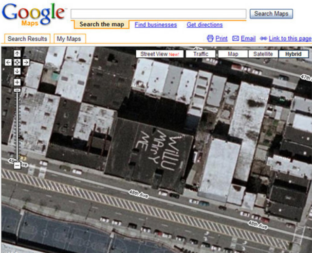
There’s a building in some locality on which somebody has proposed. Though the actual location of this weird place is not known, this image is one of the weirdest places on Google Earth.
4. Shamrock Maze in Dublin
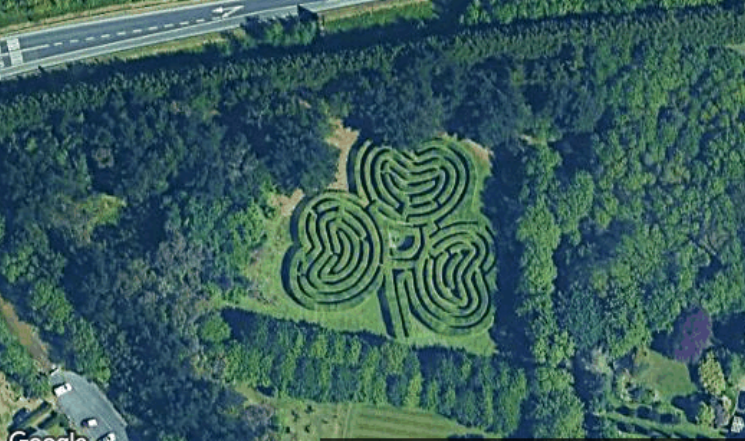
An amusing hedge labyrinth may be found just off a major Irish highway south of Dublin Airport. These major roads in Ireland are also called motorways.
Though no information can be found on this, the road leading to it is blocked by a large metal gate in Google Street View. The notice informs that it’s private property guarded by attack dogs.
5. Lake on an Island or Island on a Lake
This is the next weird thing on our list. Its an island-in-a-lake-on-an-island-in-a-lake-on-an-island. This is something very interesting and rarely seen. This image is taken from a tiny island that is situated inside a crater lake on an island known as Volcano Island. It is situated on an island itself called the Philippines.
In the early days of Google Earth’s existence, this was supposedly the biggest of its sort that had been seen for years.
6. Google Escher Effect – Paris, France
In cases like these, photographs of structures being shot from various angles, are stitched together satellite images and aero images of cities. Taller structures at each image’s margins look to be leaning toward or away from one another at sharp angles after being stitched together.
7. Luecke Farm, Texas
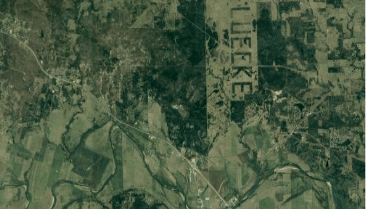
There’s a farm deep in the heart of Texas, and a narcissist farmer lives there who has written his name on his field.
Austin’s Luecke Farm is a ranch located approximately an hour southeast of the capital city. The farmer cut down the majority of the trees to make room for his cattle, but he kept others to serve as an animal habitat.
This is not just ecologically friendly, but NASA utilizes this three-mile-long landmark to calibrate its satellite and aerial photography sensors.
8. Weird Wheels
Google Earth has detected some ancient creativity carved into the surface of the globe, including wheel-shaped geometric formations that may stretch back some 8,500 years. These are even older than Peru’s Geoglyphs that are known as Nazca Lines.
9. Graffiti in Google Maps
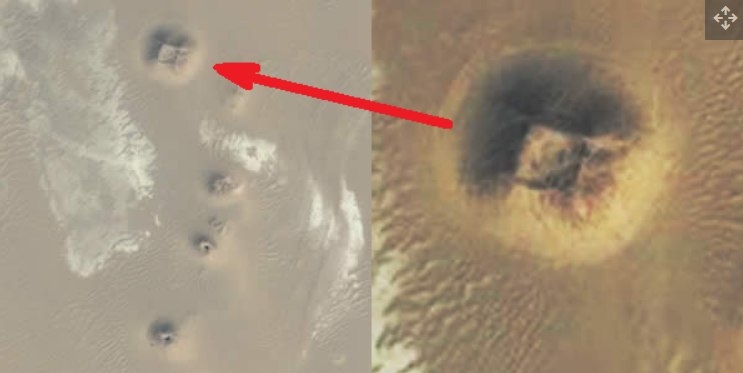
Cerro Prieto, the crater of an extinct volcano is situated in Baja California. Graffiti large enough to be visible from a height seems to have been added by many of the site’s visitors. People standing on the eastern rim of the crater’s rim may view the graffiti, which suggests it was intended for them to see. You can refer to the photo above to have a clear image.
10. “Welcome to Cleveland” Milwaukee, Wisconsin
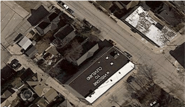
This one is my favorite. There’s a house in Milwaukee, Wisconsin on the terrace of which, it is written: “Welcome to Cleveland”. So, whenever your plane moves above Cleveland, you can see the message.
11. Bull’s eye
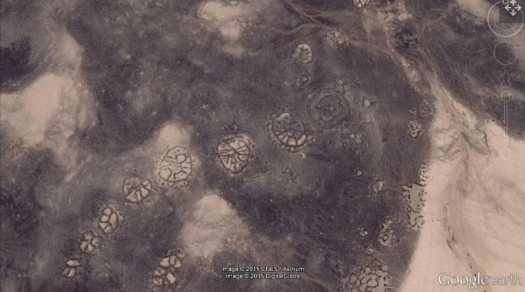
Middle Eastern “wheels,” which appear like bull’s eyes with three triangles pointing to the eye and a little pile of stones going to the bull’s-eye wheel, is the next on our list.
It is described as a “central bull’s-eye tomb with, in this case, three triangles with at least part of a connecting line of stone piles flowing to the center” by co-director David Kennedy of Western Australia University.
12. Mystery Stone Arrow
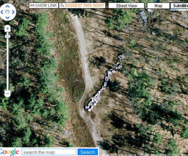
Somewhere in North America, there’s an arrow on a roadside made of stones. The exact location of this scenario is still unknown. But it has made us think about whether this stone arrow is man-made or nature-made.
13. Giant Pac-Man Game on Breckenridge Road, Tewksbury, MA
Would you like to see your neighborhood transformed into a huge Pac-Man game? But the sound of the grinding tiles would likely keep you awake at night.
The pic above resembles the legendary game of Pec Man. This place is located in Tewksbury, Massachusetts.
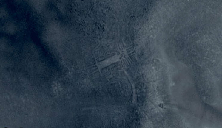
14. Mysterious pyramid
The image is from Google Earth showing an anomaly that some belief is an unexcavated Pyramid. Many abnormalities in Egypt have been seen using Google Earth in recent years, however, there is disagreement as to whether they are natural or manmade.
The quantity and extent of excavations in Egypt have been constrained due to the country’s security and economic conditions.
15. Auto Antics
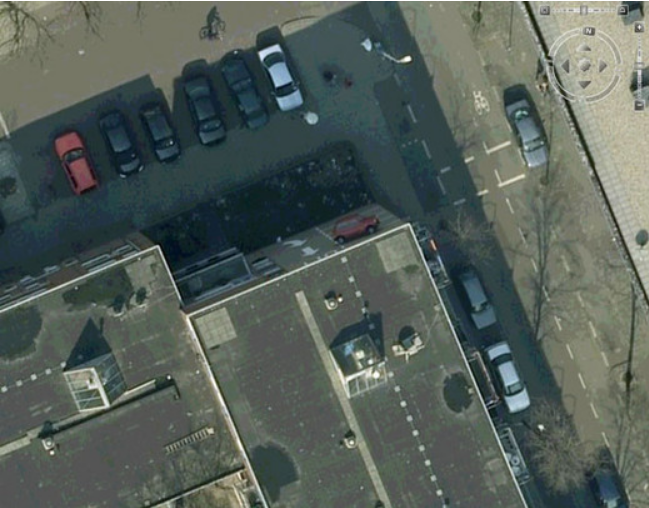
Do you cry about a parking place in your locality? Look at the picture above. In Westenbergstraat, Netherlands the car drivers are parking cars on the sides of the wall. So, don’t worry about your parking, at least you don’t have to park over a wall.
16. Egyptian Pyramids
Egypt is known for its pyramids. These Pyramids are dated back to some 1000-2000 years. Look at the picture above. Can you tell whether this pyramid is eroded or it’s just like that only? Do tell us your views in the comment section below.
17. Stealth Bomber Swimming Pool at Whiteman AFB
This Swimming pool was kept blurred by Google Earth for a long period. But now the secret has been revealed. Street Bombers are Amphibians. This pool, before 2007, looked like a slate of Ice.
As such, Google Earth amended its mistake and made it clear in recent times. This Swimming pool is situated on the outskirts of Whiteman Air Force Base in Missouri, home of the B-2 Stealth Bomber.
18. Face of Satan
There’s an anonymous man who claimed this pattern to be the face of Satan. The pattern formed by the local roads of this place is compared to a symbol. This symbol, according to him belongs to Satan. This brings thrill into reality. What do you think?
19. Cruise Ship Mall, Hong Kong
For a long time, a sign near San Diego’s harbor said, “Cruise ships use airport exit.” Following the warning, this ship veered off course and became entangled in a jungle of Twitter hashtags.
Whampoa Gardens is a massive Hong Kong housing complex constructed on the site of old dockyards, including a ship-shaped commercial mall.
20. Phantom Island

A Manhattan-sized island in the South Pacific was “undiscovered” in 2012 by an Australian research team. Sandy Island, a strange location northwest of New Caledonia, was shown on maps. It even appeared on Google Earth as a black polygon. But when scientists decided to go there in later 2019, it was open water instead of Solid Ground.
21. Man Shaped Lake, Brazil
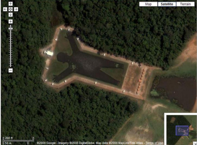
You may have seen lakes and rivers of many shapes. But this is different. In Brazil, there’s a place where the lake is designed in the shape of a man. This is a man-made lake otherwise it would not have been formed.
22. Parque Gulliver in Valencia, Spain
You must have read Gulliver’s Travel in your Childhood. This place in Parque Gulliver in Valencia, Spain still torments the Gullivers by Lilliputians. This place is named after the Gulliver.
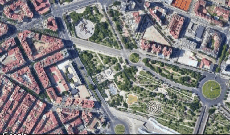
It offers tons of interesting things. In the image, you can see. He is on the upper left side with big houses and on the lower right side, you can notice the Gardens of Turia.
23. Iraq’s Bloody Lake
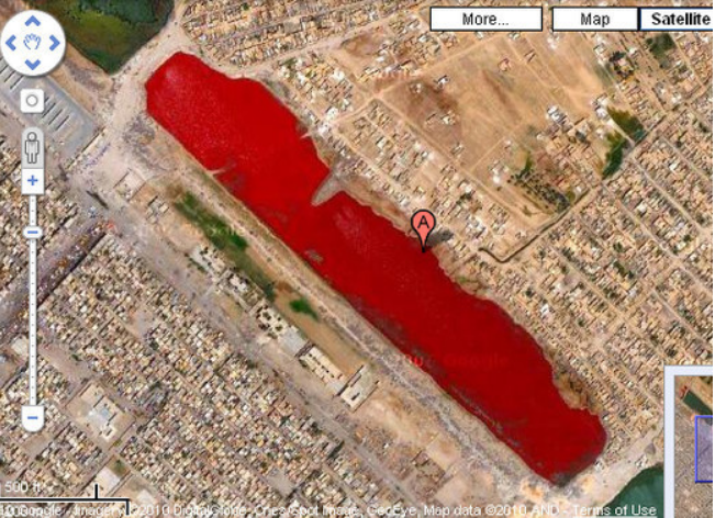
There was much dark speculation about this blood-red lake in Iraq’s Sadr City when it was discovered in 2007. Somebody claims that Iraqi slaughterhouses occasionally pour blood into canals. Although no official explanation has been provided, it’s more probable that the color is due to sewage, pollution, or a water-treatment procedure.
24. Atacama Giant
On the Cerro Unitas peak in the Atacama Desert, Chile, there is an anthropomorphic geoglyph called the Atacama Giant. It is a Prehistoric anthropomorphic figure with a length of 119 meters. It was a deity for the inhabitants of the area from AD 1000 to 1400 and was the world’s largest.
25. Puzzling Pentagram
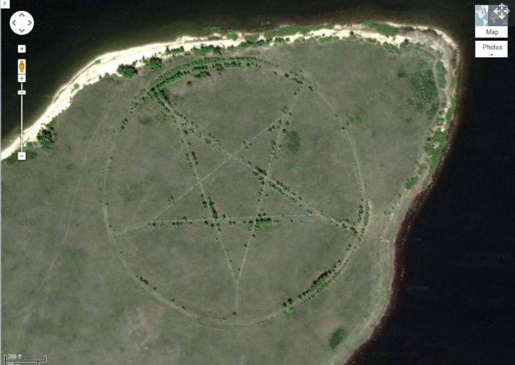
In the area of Central Asia, there’s an isolated corner of Kazakhstan. In that isolated corner, there lies a big Pentagonal structure measuring up 1,200 feet (366 meters) in diameter.
You can see the pentagonal structure bounded by a circle, which is located on the southern shore of the Upper Tobol Reservoir. Some people relate this structure to devil’s workshops or nefarious religious sects. What are your views on this?
26. Issaouane Erg desert – Dunes (Algeria)
This is a beautiful picture of the Erg Desert. You can see the 3 Dunes. These dunes are just the tip of the iceberg as there are hundreds and thousands of dunes just like that. The color combination and shape of these dunes in the desert are amazing.
27. UFO Landing Pad Mat in Holland
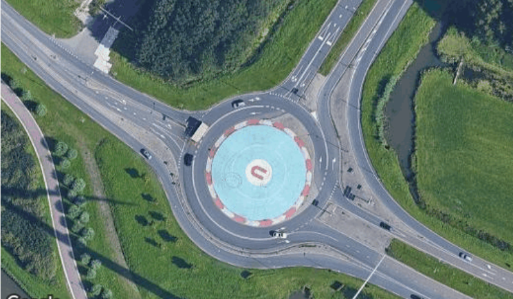
In Poland, the state has made an official UFO Landing site with traffic advisory lights to completely direct the aliens. It’s a roundabout between roads and the area between it is where the UFO landing pad has been made.
So, the next time the aliens are coming, they know where to land their Unidentifying Flying Object(UFO).
28. Abandoned Launch Sites
During the Cold War, almost 300 Nike missiles, which were supersonic surface-to-air missiles, were ready to fire at nearly 300 locations around the United States. Even nuclear warheads were on some of the rockets. Once a necessary weapon, long-range intercontinental ballistic missiles are now considered obsolete.
29. Fingerprint on Lens in Brighton, UK
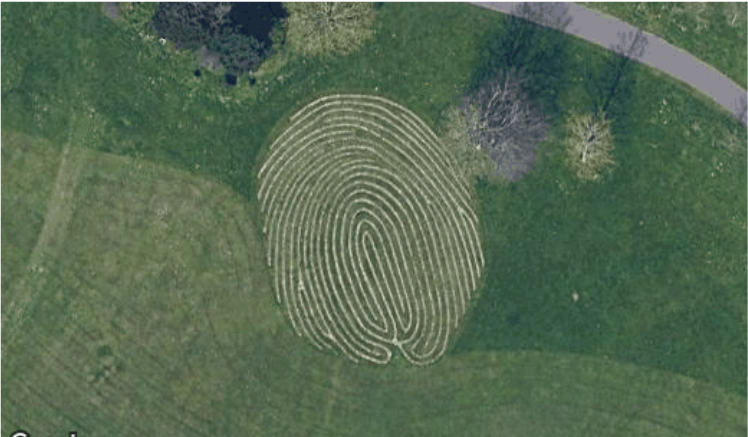
Did you ever imagine a field in the shape of a fingerprint? Think no more, there’s a site in Brighton, the United Kingdom where you can see the Fingerprint shaped area.
30. Desert Breath
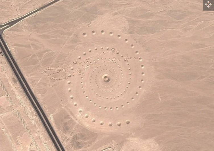
An alternative world via a spiral door? What if it’s a communication from another planet? What if it’s a relic from a long-dead deity?
Desert Breath, an artwork in the Egyptian desert near the Red Sea, has a massive spiral shape. Designed to honor “the desert as a state of mind, a landscape of the mind,” the 1 million-square-foot (100,000-square-meter) artwork was completed in March 2007 by Danae Stratou, Alexandra Stratou, and Stella Constantinides.
These are all the 30 weird places on Google Earth. These images are taken from google earth and you can revisit them as soon as possible. Because, when these came to the notice of Google, they might remove them.

Stephen McDaniel Story: The Monstrous Murderer who Butchered his Ex-Classmate
Who is caroline ellison meet sam bankman-fried’s rumored ex-girlfriend, dexter killer: everything about mark twitchell, the killer who wore a hockey mask, leave a reply cancel reply.
Save my name, email, and website in this browser for the next time I comment.
Most Popular
The teal mango.
We're a Digital Platform offering the Latest Updates and News from Entertainment, Technology, Lifestyle and Food Industry.
- DMCA Policy
- Terms And Conditions
- Corrections Policy
- Fact Checking Policy
- Cookie Policy
- Ethics Policy
- Editorial Policy
- Privacy Policy
EDITOR PICKS
15 Secretive Places You Can Now See on Google Earth (And 3 You Can't)

Blurred out and pixelated

The advent of easily-accessible satellite imagery in the form of Google Maps and Google Earth has likely raised some security experts' blood pressure over the years. Local law can restrict aerial photography or satellite imagery of sensitive sites; when Google gets imagery from commercial entities or government agencies, those sites sometimes come pre-blurred, according to The Google Earth Blog , which is not affiliated with Google.
Over time, though, laws have been changed, new sources of imagery have become available, and Google has quietly lifted the veil on many of these secretive sites. Here are the government buildings, military installments and industrial centers you can now peruse on Google Earth — and three places still shielded from prying eyes.
The U.S. president's digs

When Google Maps and Google Earth first launched, 1600 Pennsylvania Avenue in Washington, D.C., was whited out. It was a short-lived attempt at national security protection; comments on a 2005 post on the website Google Sightseeing suggest that the blurring was lifted by early 2006.
Blurred or not, the White House is surrounded by multiple layers of security. According to ABC News, this includes windows made of bulletproof glass, alarms and infrared sensors along fencelines, armed security teams on the property grounds and teams of snipers on the White House roof.
Still, it's pretty common for people to try to jump the White House fence. Usually, they're caught quickly, but there have been major lapses, too. One notable failure was an incident in March 2017 in which a man from California jumped a fence and spent 17 minutes on the grounds with a backpack that contained pepper spray.
One Observatory Circle

While the White House was brought into view fairly quickly after Google Maps and Earth launched, the Vice President's residence remained obscured for the entirety of Dick Cheney's tenure in the office. One Observatory Circle in Washington, D.C., remained blurred out on Google Earth until Jan. 18, 2009, according to a Gawker post from the time. Users can still see the slate-roofed 1893 structure and its surrounding grounds without pixilation.
Like the White House, the Vice President's residence has plenty of on-site security. Former VP Joe Biden allegedly let some of those security secrets slip in 2009, when he told dinner companions about a bunker underneath the home, according to Fox News . His staff later released a statement saying that the VP was referring not to a classified bunker location, but to a secure upstairs workspace.
The U.S. Capitol Building

The U.S. Capitol was another U.S. government site pixelated when Google Earth first launched in 2001. Things got worse before they got better. According to a 2007 article in the Washington Post , Google originally launched its views of D.C. with U.S. Geological Survey satellite imagery that censored the Capitol, as well as the White House. In June 2007, the company opted to use imagery that didn't block these sites, but that was much older (and blurrier). For a while, D.C. was a confusing mishmash of clear USGS aerial photography and blurry, out-of-date commercial satellite imagery. Today, it's all cleared up.

Ah, HAARP. The High Frequency Active Auroral Research Program is better known for what it doesn't do than what it actually does. HAARP is an Alaska-based program for studying the ionosphere , an upper layer of the atmosphere, in hopes of developing better radio communications. To conspiracy theorists, it controls the weather and chemtrails and the minds of the populace and … you get the idea.
Various blog posts and news items claim that HAARP's facility in Gakona, Alaska, was once blurred on Google Earth. A look through the program's history page shows no deliberate censorship of the facility, though there are large defects in the satellite data that partially cover the site until 2013. (The facility holds an annual open house and posts pictures of its interior on Facebook, so it's unlikely that researchers are sweating some overhead shots.)
The Faroe Islands

The Faroe Islands, halfway between Norway and Iceland, were once largely a fuzzy blur on Google Earth. Today, they're crystal-clear, with the exception of two small islands, Fugloy and Svínoy. An Australian news article once speculated , with no particular evidence, that the blurring had to do with fishing rights. It's also entirely possible that the blurriness has nothing to do with censorship and everything to do with the technical challenges of getting high-resolution imagery for every place on the planet.
According to Google, some fuzzy places, particularly in remote regions, are simply the result of a lack of good aerial images. When better imagery becomes available, Google incorporates it, so "censored" spots may become clear with the next software update.
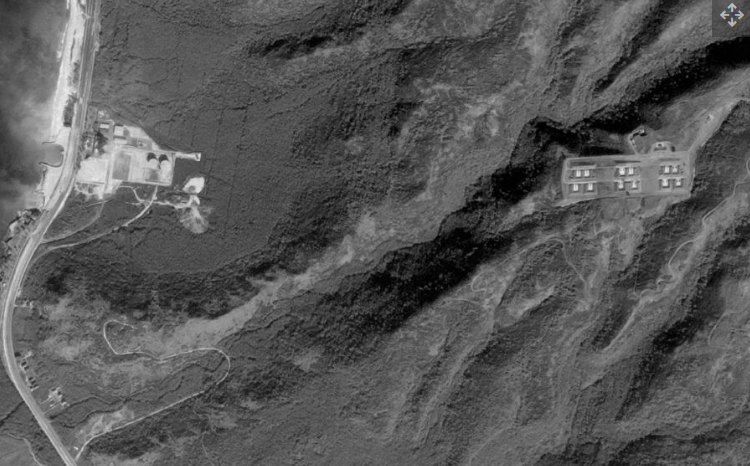
Volkel Air Base, the Netherlands

The censorship of Volkel Air Base in the Netherlands was definitely no accident. The air base, which is the site of a U.S. nuclear weapons repository, once appeared as a patchwork of green and white pixels . The presence of the nukes first became wide public knowledge in 2010, when Wikileaks leaked a diplomatic cable that mentioned their existence. The former Prime Minister of the Netherlands confirmed the presence of the nukes in 2013, calling them "absolutely pointless," according to The Telegraph .
The nukes make it clear why the Dutch felt rather secretive about the base, but Google unblurred it on Sept. 14, 2016.
Noordeinde Palace, the Netherlands

The Dutch are rather famous in satellite-imagery-loving circles for their enthusiastic pixelation. On Google Earth, the country was dotted with pixelated splotches covering military bases, government buildings and more. According to CNN , Dutch law changed in 2013 to lift this censorship, and the Netherlands have become considerably clearer since. (There are some spots, like a blob in Noordwijk aan Zee , where new satellite imagery has yet to become available since the law change.)
Most of the censored areas in the Netherlands used the large, pixelated mask still seen in Noordwijk aan Zee to obscure sensitive sites, but Noordeinde Palace in The Hague got a more personal touch. The office building of the country's kind was once painstakingly blurred pixel-by-pixel with a much more delicate hand than usually used on the country's satellite imagery. Until 2013, the palace, as seen on Google Earth, looked like something out of an old Atari game.
The Elmira Correctional Facility, New York

The Elmira Correctional Facility in Elmira, New York, is a maximum-security prison with a wild history. In 2003, two inmates, Timothy Morgan and Timothy Vail, made paper-mache models of themselves using their own hair, left them snuggled in their beds, and escaped through a hole they'd made with a sledgehammer through the ceiling of their cell. They were recaptured two days later. More recently, in the summer of 2017, the prison was hit with a series of brawls involving homemade weapons, according to USA Today .
Around 2006, the images of Elmira on Google Earth were very low-resolution, reportedly over concerns that satellite imagery would be used to stage helicopter escapes from the prison — though it may just have been poor-quality satellite imagery, because the surrounding neighborhoods weren't particularly sharp, either. However, helicopter escapes have happened. The first, made famous by the 1975 movie "Breakout," took place at the Santa Martha Acatitla prison in Mexico. New York businessman Joel David Kaplan, who was serving a sentence for killing his business partner while in Mexico, fled the prison by helicopter. He made it to California and was never recaptured, no satellite imagery required. According to Time magazine , Kaplan's wife had visited the prison a day before the escape with a male companion who seemed to be scoping out the prison yard.
The prison roof became much more clear in a 2013 Google Earth update.
Bhabha Atomic Research Center, India

BARC, or the Bhabha Atomic Research Center, is the home of India's nuclear power research program. It's in Mumbai, and its appearance on Google Earth has been a headache for India's officials. In 2005, the then-president of India, A.P.J. Abdul Kalam, called for new laws to obscure India's sensitive sites; in 2006, the nation's defense and science agencies started looking into how to obscure or downgrade the available imagery, according to Phys.org .
Little came from these efforts; the sites remain clear. But India's concerns were perhaps warrented. In 2011, the nonprofit Institute for Science and International Security used Google Earth imagery to suggest that the country might have been building a new uranium-enrichment facility, and it has been tracking the country's uranium-enrichment infrastructure with satellite imagery since.
Ingolstadt Manching Airport, Germany

Sometimes, a spot that looks secretive on one mapping service is clear as day on another. That's the case with the Ingolstadt Manching Airport in Germany, a military air base that also serves some private charter flights. On Microsoft's Bing Maps, the airport is blurred out. On Google Earth, it's clearly visible. The airport has aerial imagery of its own layout right on its website , so it's possible that Bing's blurring is just a holdover from old, redacted satellite imagery and that Google has a less secretive source.
Current page: Page 1
Sign up for the Live Science daily newsletter now
Get the world’s most fascinating discoveries delivered straight to your inbox.
Stephanie Pappas is a contributing writer for Live Science, covering topics ranging from geoscience to archaeology to the human brain and behavior. She was previously a senior writer for Live Science but is now a freelancer based in Denver, Colorado, and regularly contributes to Scientific American and The Monitor, the monthly magazine of the American Psychological Association. Stephanie received a bachelor's degree in psychology from the University of South Carolina and a graduate certificate in science communication from the University of California, Santa Cruz.
Experts predicted way more hurricanes this year — here's the weird reason we're 'missing' storms
Deep below the Arctic Ocean, some plants have adapted to photosynthesize in almost near darkness
'We have changed the view of our galaxy forever': Astronomers capture most detailed ever infrared map of the Milky Way
Most Popular
- 2 'The secret to living to 110 was, don't register your death': Ig Nobel winner Saul Justin Newman on the flawed data on extreme aging
- 3 New self-swab HPV test is an alternative to Pap smears. Here's how it works.
- 4 Nuking an asteroid could save Earth from destruction, researchers show in 1st-of-its-kind X-ray experiment
- 5 Experts predicted way more hurricanes this year — here's the weird reason we're 'missing' storms
- Search Search for:
- Architecture
- Military Tech
- DIY Projects
20 Strangest Places You Can See On Google Earth

Google Earth gives people the chance to explore the entire surface of the planet from their desktop with just a few easy clicks. People can see the deepest of oceans and even 3D images of buildings. But there are some cool and unbelievable images that are worth checking out on Google Earth and here are 20 of the most amazing ones.
Come Downtown and Play, Memphis, Tennesse, USA (35.141533, -90.052695)
The Barringer Meteor Crater, Winslow, Arizona, USA (35.027185, -111.022388)
Oil Fields, Rio Negro, Argentina (37°39’16.06?S 68°10’16.42?W)
Potash Evaporation Ponds, Moab, Utah, USA (38°29’0.16?N 109°40’52.80?W)
Homebush Bay, Sydney, Australia (-33.836379, 151.080506)
Massive Herd of Water Buffalo, Kigosi Game Reserve, Tanzania (4°17’21.49? S 31°23’46.46? E)
Hear-Shaped Lake, Columbia Station, Ohio, USA (1.303921, -81.901693)
Giant Target, Nevada, USA (37.563936, -116.85123)
Coca-Cola Logo, Arica, Chile (-18.529211, -70.249941)
Swastika-Shaped Building, Coronado, California, USA (32°40’34.19?N 117° 9’27.58?W)
Random Triangle, Wittmann, Arizona, USA (33.747252, -112.633853)
Guitar-Shaped Forest, Córdoba, Argentina (-33.867886, -63.987)
The Badlands Guardian, Walsh, Alberta, Canada (50° 0’38.20?N 110° 6’48.32?W)
Jet in a Parking Lot, 92410 Ville-d’Avray, France (48.825183, 2.1985795)
Mysterious Pattern, Gobi Desert, China (40.452107, 93.742118)
Another Mysterious Pattern, Red Sea Governorate, Egypt (27°22’50.10?N, 33°37’54.62?E)
Boise National Forest, Boise, Idaho, USA (43.645074, -115.993081)
Nevada, USA (37.629562, -116.849556)
Giant Pool of Hippos, Katavi National Park, Tanzania (6°53’53.00? S 31°11’15.40? E)
Heart-Shaped Land Formation, New Caledonia, France (20°56’15.47?S, 164°39’30.56?E)

amazing photogrophy

47.153769, 27.597610

Bago City Reaches City In Whole WORLD………………….AACLP MACF
Leave a Reply Cancel reply
Your email address will not be published. Required fields are marked *
Notify me of follow-up comments by email.
Notify me of new posts by email.

0, text: error()">
0, text: error(), css: errorCssClass">
Reset your password
Enter your email address or username and we’ll send you a link to reset your password
Check your inbox
An email with a link to reset your password was sent to the email address associated with your account
Provide email
Please enter your email to complete registration
Activate to continue
Your account isn't active yet. We've emailed you an activation link. Please check your inbox and click the link to activate your account
0, text: error" style="display: none;">
0, text: success" style="display: none;">
- Relationships
The Bored Panda iOS app is live! Fight boredom with iPhones and iPads here .
- Partnership
- Success stories
- --> -->