- Muskwa Kechika
- Alaska Highway

Liard River Hot Springs
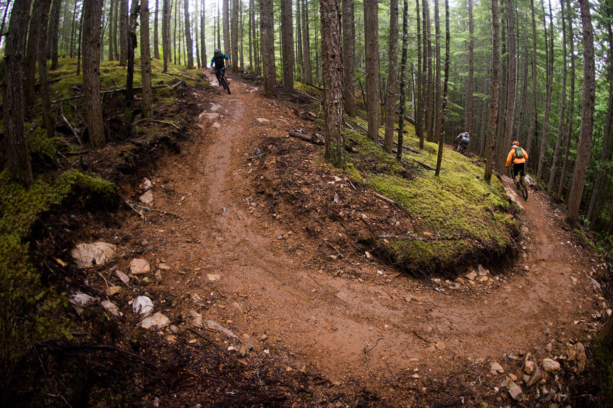
- Ancient Forest
- Guided Adventures
- Photography
- Tumbler Ridge UNESCO Global Geopark
- Winter Experiences
- Historical & Cultural Experiences
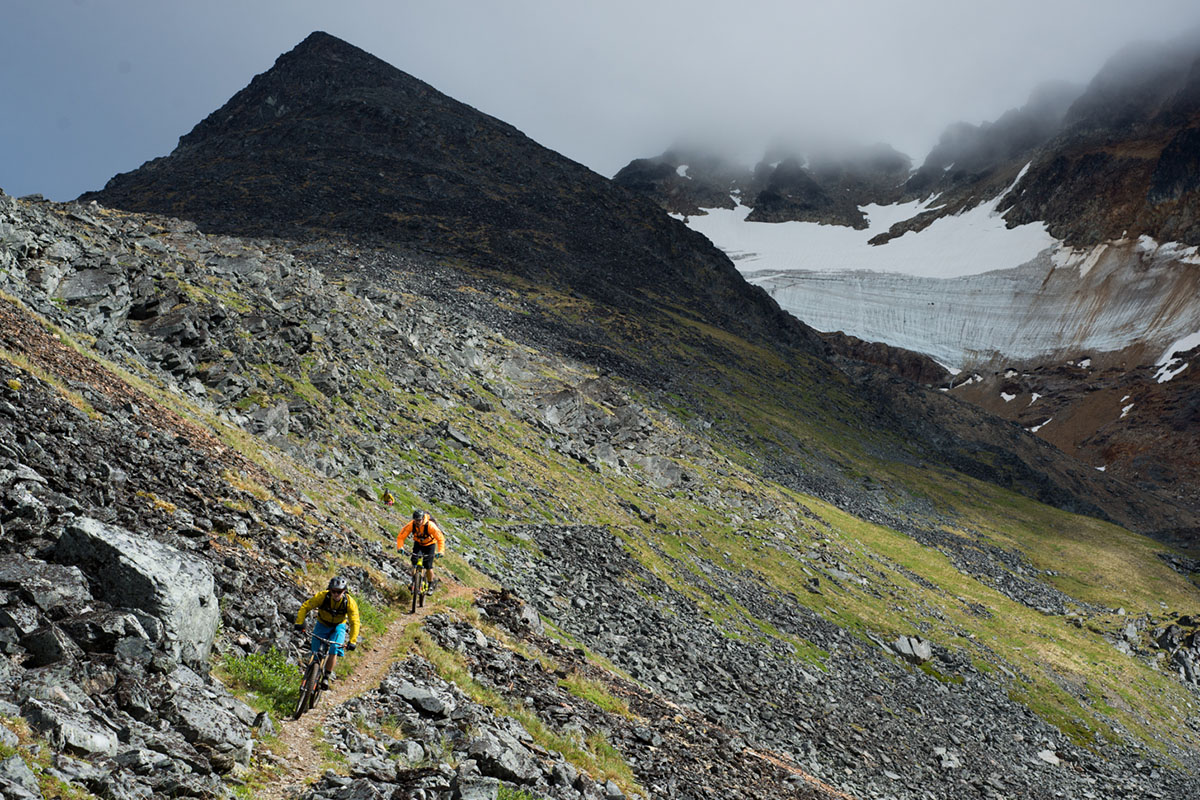
- The Big Five
- 10 Day Trip
14 Day Trip
- Visit Responsibly
- Know Before You Go
Home / Itineraries / 14 Day Trip
FOLLOW THE GREAT NORTHERN CIRCLE ROUTE
This giant loop of Northern British Columbia is the ultimate road trip. Follow the Alaska Highway north, through the Northern Rockies, and back south on the Stewart-Cassiar Highway before heading back along Highway 16. The natural scenery is staggering and the wildlife sightings are endless. Uncover the past at historic and cultural sites, pull over to camp, hike, fish, boat, or take moments to just sit in nature. The boundless wilderness on this trip is unmatched anywhere else in British Columbia.

Prince George, BC
Prince george.
Begin this journey through the north in Northern BC’s largest city. Hit the town for pints at local breweries, explore the thriving culinary scene, and wander downtown shops, galleries, and museums.

Mackenzie, BC
Take a short detour to Mackenzie and experience its small town charms and spectacular wild landscape. Rich in history, including that of many indigenous communities, Mackenzie offers ample opportunity for outdoor recreation—including paddling, hiking and mountain biking—with unmatched views from atop Morfee Mountain.

Mile 0, Dawson Creek
Mile 0 in dawson creek.
Dawson Creek is where the historic Alaska Highway journey begins. Home to the Mile 0 landmark, road trippers embarking on this iconic trip can learn all about the highway’s history. Visit the N.A.R. Station Museum, tour downtown Dawson Creek, and see the Pouce Coupe trestle bridge before heading north.

Kiskatinaw Bridge
See the first curved wooden bridge ever built in Canada and one of very few still standing today. Visitors can stand below at Kiskatinaw Provincial Park and marvel at this three-span, timber-truss engineering wonder before cooling off with a swim in the Kiskatinaw River.

Fort Nelson Heritage Museum
Fort nelson.
Thousands of square kilometres of wilderness surrounded Fort Nelson. This is the gateway for expeditions into the Muskwa-Kechika, outdoor adventure, and the last stop before long, remote stretches of road on the Alaska Highway. Go back in time and see historic artifacts and memorabilia from the pioneer days at the Fort Nelson Heritage Museum.

Stone Mountain Provincial Park
This is the beginning of the incredible Rocky Mountain scenery found along the Alaska Highway. Camp overnight at Summit Lake, fish for trout, and hike the Summit Peak Trail or other backcountry hikes in the area. Keep an eye out for Stone’s sheep balancing on the cliffs in this high-elevation park.

Muncho Lake Provincial Park
The mineral-rich, jade-coloured waters of Muncho Lake and the squished limestone of Folded Mountain are the scenic highlights here. Visitors can spot wildlife or spend days exploring the lake by canoe and kayak. Join on a flightseeing tour or fly-in fishing trip fish and stay overnight in the park or at Northern Rockies Lodge.

Walk along wooden boardwalks to relax in the wilderness at these natural hot springs—the largest in Canada. Sink your toes into the sand and rest your back against the earth basin of the 42-52°C (108-126°F) Alpha Pool surrounded by a lush boreal forest. Visitors can camp overnight in the park to spend a time relaxing.

Watson Lake, Yukon
Leave your own mark at the world-famous Sign Post Forest. Wander pathways lined with over 85,000 signs left behind by travellers and road-trippers—a tradition started by homesick soldiers who were building the Alaska Highway in 1942. Don’t miss a chance to take a tour of the Northern Lights Space and Science Centre to learn the science behind the aurora borealis phenomenon.

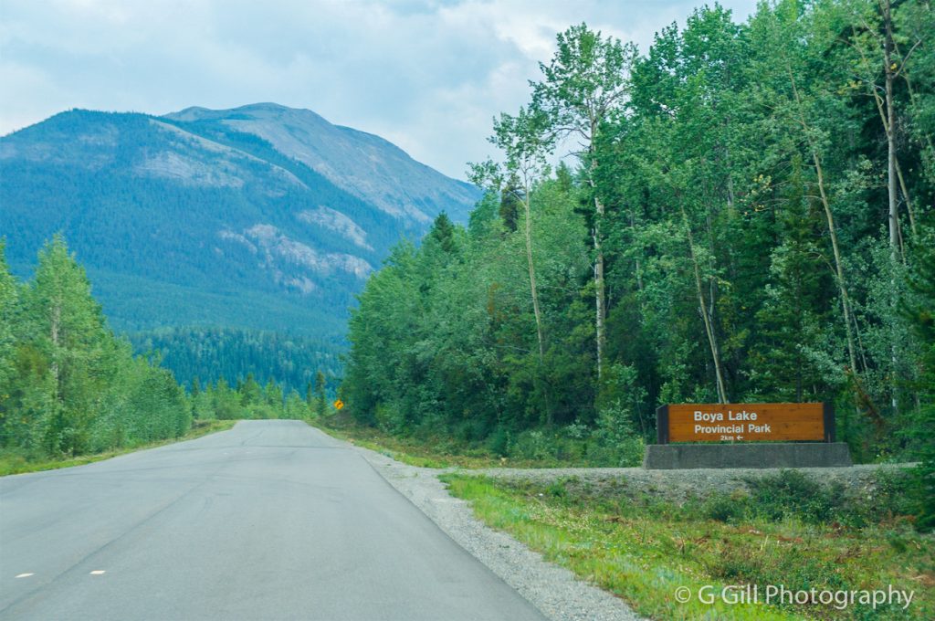
Tā Ch’ilā Provincial Park (Boya Lake)
This draw at this provincial park is the lake and its crystal-clear waters that shimmer aquamarine. This seemingly tropical paradise is the perfect place to paddle the inlets, islands, and bays by canoe or kayak, camp overnight, and explore the gentle interpretative walking trails of the park.

Kinaskan Lake Provincial Park
Nestled between the Skeena and Coast mountains, the views from this campground are striking. Avid hikers can home base here before exploring backcountry trails that lead into the Mount Edziza Provincial Park trail system. Visitors can also hop in a floatplane for easy access to this wilderness area, along with nearby Spatsizi Plateau Wilderness Provincial Park.

The Hazeltons
Sitting at the confluence of the Bulkley and Skeena rivers, this area is home to one of the most impressive Indigenous cultural sites and learning centres in BC. Explore the ‘Ksan Historical Village and Museum to gaze at totems that stretch to the sky and learn about the Gitxsan peoples who have called this place home for thousands of years.

This mountain town is full of friendly locals and adrenaline-inducing outdoor adventures. If you need to burn some energy at the end of this road trip, the bike trails, hiking routes, rivers, and lakes here will do the trick. Come winter, Hudson Bay Mountain and Hanklin-Evelyn Backcountry Recreation Area offer resort and backcountry skiing.

For mountain bikers and anglers, Burns Lake is paradise. Ride more than 90 km (56 mi) of world-class trails at the Boer Mountain Recreation Site, complete with a trailside campground at Krager Lake. For anglers, there are more than 25 lakes in the surrounding area known as top spots for sport fishing and boating in BC.

This wilderness city is the perfect place to end a long journey through the remote north. Hit the town for pints at local breweries, explore the thriving culinary scene, and wander downtown shops, galleries, and museums.
More from the blog
A guide to winter in bc’s northeast.
Skip mountain villages with bustling crowds and instead make your way to BC’s Northeast — a region that knows how to do winter well.
Wilderness Lodges and Campgrounds in Northeast BC
The raw and rugged scenery of BC’s Northeast is anything but ordinary. From lakeside A-frame cabins to remote fishing outposts set deep in the heart of the Muskwa-Kechika, here are nine cool stays that aren’t your average hotel.
Paddling in BC’s Northeast Region
One glimpse at Northeast BC’s lake-dotted landscape reveals a paddler’s paradise, one that promises few crowds and plenty of scenery. Here you’ll find pristine waterways framed by sweet-smelling pine and spruce forests and well-stocked lakes, home to rainbow trout, walleye, and northern pike.
YOUR TRAVEL GUIDE
Sign up to our newsletter for the latest experiences and guides
The Great Northern Circle Route Is a Bucket List-Worthy Canadian Road Trip

The Great Northern Circle Route in Northern BC is full of amazing sights and stops.
For those wanting to go on a bucket-list-worthy road trip this summer but still stay close to home, it’s time you discovered the Great Northern Circle Route in Northern BC.
This spectacularly scenic route puts the natural beauty of Canada on full display: monumental mountains, untouched wilderness, shimmering blue lakes, plus gorgeous flora and fauna surround you as you travel through this immense untamed area.

In Northern BC, beauty is more than skin deep
Many Canadians know that British Columbia is gifted in the natural beauty department but, unless you’ve travelled to its north, you haven’t yet seen the best of it. This is where the province’s dramatic scenery meets outdoor adventure, sporting activities, animal spotting, and heritage sites.
Northern BC begins at the city of Prince George and extends up to the Yukon/Alaska border. This vast region also encompasses the Haida Gwaii archipelago. Hiking, swimming, fly fishing, kayaking — all can be done in this natural playground and in one epic road trip.
This spectacularly scenic route puts the natural beauty of Canada on full display.
Plan your route to adventure
To properly take in the sights and scenery of Northern BC, plan to follow the entire Great Northern Circle Route, covering 3,200 kilometres. You’ll head north from Prince George, through Pine Pass and the Peace River Regional District, along the historic Alaska Highway (#97). Make sure to buckle in as you travel up through the Yukon and down the Stewart-Cassiar Highway (#37), then across the Yellowhead Highway (#16) back to Prince George.
Throughout your journey, you will discover prehistoric worlds, the culture of Indigenous peoples, quaint towns, historic museums, protected parklands, glaciated valleys, misty rainforests, and rugged mountains.
Stops along the way
Your journey doesn’t need to end here. You can always take an additional five to ten days to paddle the gorgeous 120-kilometre route through the Nation Lakes chain of waterways — or maybe that’s next year’s adventure?
Prince George

Take either air, road, or rail to get to the starting point of your journey, the modern city of Prince George. Called the “basecamp of the north,” this is where you can visit BC’s northernmost winery or a local brewery, the Huble Homestead Historic Site, or the world’s only inland temperate rainforest. You can also get in a game of golf on tamed, manicured grasses before they turn wild, stock up on supplies, and drink your fill of excellent coffee before you hit the road.
Chetwyn and Tumbler Ridge

This section of road will take you through Chetwynd, home to more than 120 wooden chainsaw carvings, which line the streets. Starting out as an idea in 1992 to carve three bears to commemorate the anniversary of the Alaska Highway, the momentum grew to include the annual International Chainsaw Carving Competition, now drawing in carvers from all over the world.
For natural beauty lovers, your next stop should be the Tumbler Ridge Geopark, the only UNESCO Global Geopark in Western Canada. Here, you’ll find falls larger than those in Niagara (don’t miss a jet boat tour for total immersion) and more than 20 trails for every type of hiker, from vigorous alpine treks to meandering strolls. There’s even a car route to follow if that’s more your speed.
Dawson Creek

This is a good spot to park for the night but, before you do, take a selfie at the historic Mile 0 sign, which marks the beginning of the historic Alaska Highway. This 1,930 km scenic route is open all year, and joins highways to Edmonton and Prince George. Check out the Northern Alberta Railway Station Museum located in a renovated grain elevator and the Walter Wright Pioneer Village.
Fort St. John

If you have a mind to go fishing, just outside Fort St. John is Charlie Lake, an idyllic spot to fish for trout, walleye, or northern pike. After a morning of casting and jigging, you’ve earned a beer at one of the local craft breweries before checking out the North Peace Cultural Centre and the Indigenous Artists’ Market before journeying on. If you can be up before dawn, you should stop to view the sunrise over Pink Mountain on your way to Fort Nelson. Up for a bit of an adventure? Travel along a bumpy logging road to view the scenic Sikanni Chief Falls, where the roar of water comes before you see the falls.
Fort Nelson

When you arrive at Fort Nelson, you’re at the gateway to the Northern Rockies. Before leaving the town, visit the Fort Nelson Heritage Museum to learn about life during the building of the Alaska Highway. Along the road, Muncho Lake offers some of the most brilliant scenery you’ll ever set your eyes upon, with jade-coloured lakes and a backdrop of towering, craggy mountains. On the way stop by Liard River Hot Springs, an ecological phenomenon with a natural river of hot water.
Watson Lake Sign post Forest

You’ll want to come prepared to make your mark at Sign Post Forest, where there are close to 70,000 license plates, road shields, and homemade signs mounted. After a bit of fun and maybe a selfie or two, the Stewart-Cassiar Highway will lead you to the crystal-clear waters of Tā Ch’ilā Provincial Park. You also may want to take a short detour to visit the Cassiar ghost town, where the chills you feel might not be from the dip you took in the lake.
Jade City to Stewart

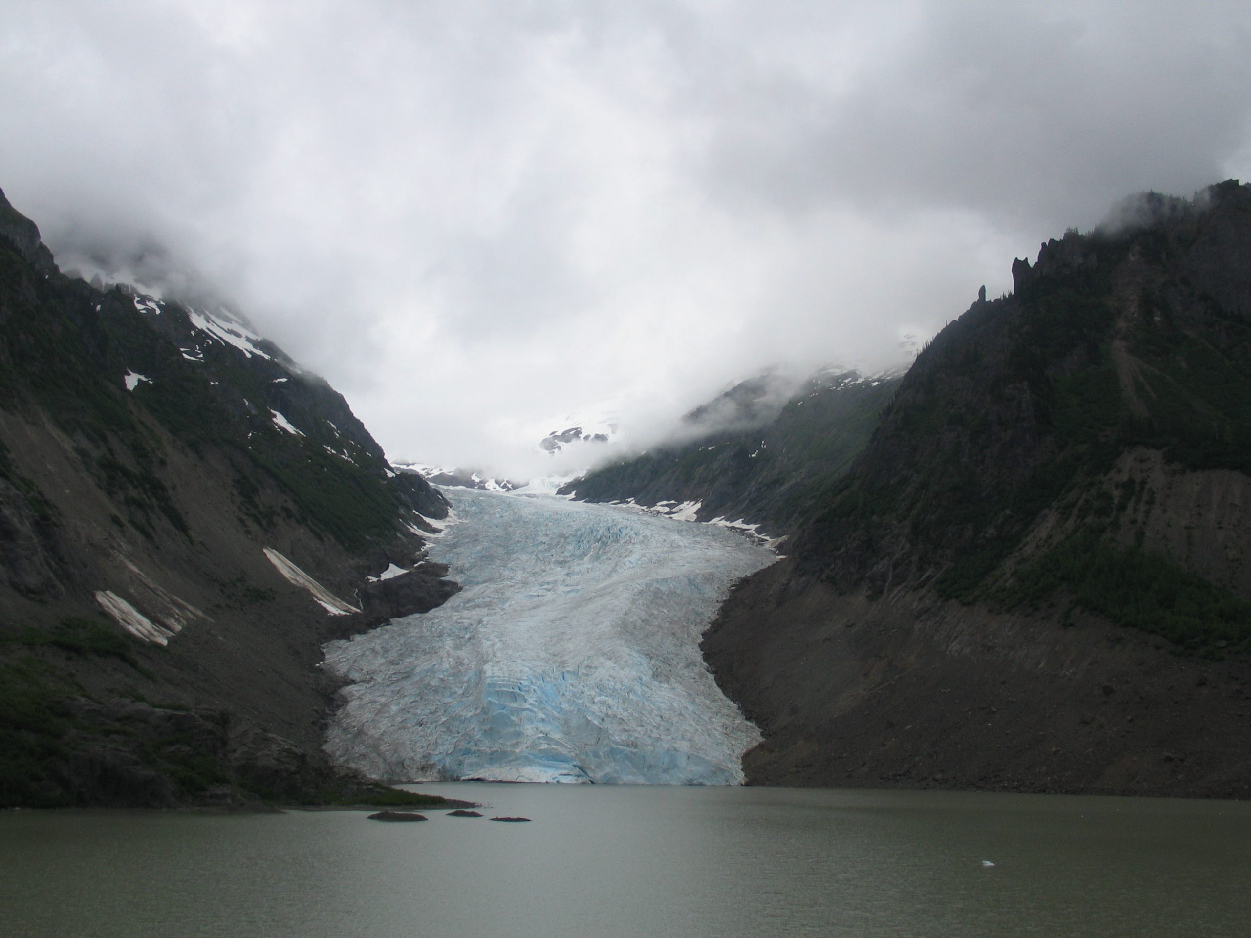
This stretch of road is all about the great outdoors — go paddling, canoe to Cascade Falls, take a small plane to the Spatsizi Plateau Wilderness Park for breathtaking, remote beauty, or go to Mount Edziza Provincial Park for the surreal volcanic landscape. Just north of the town of Stewart, if travel restrictions allow, cross into Alaska and head to the stunning Salmon Glacier. This is the world’s largest vehicle-accessible glacier and something you won’t want to miss.

Stewart to Smithers
Relive history on an interpretive walking trail at the Battle Hill National Historic Site and learn about the rich culture of the Gitxsan people at the ‘Ksan Historical Village before continuing south to Smithers.
Smithers to Fort St. James

For a change of pace, take in the town of Smithers. This is the stop to get into that ski town vibe, with a magnificent mountain backdrop overlooking an alpine-themed streetscape. After a day spent hiking or paddling, head to a local brewery, shop, or café.
The next stop is Burns Lake, known for its 90 kilometres of biking trails, and then — since you’re already in the Lakes District — don’t miss the chance to hop on a float plane and head to a remote, pristine lake that feels like it’s there only for you.
Fort St. James and the return to Prince George

This final leg of your journey takes you to the Fort St. James National Historic Site, a recreation of an 1896 Hudson’s Bay trading post. This area was originally established by explorer Simon Fraser in 1806 as an outpost for the Northwest Company and became known as the ‘Siberia of the fur trade’ due to its harsh winters, but today it’s known for its excellent fishing.
If you have a desire to experience authentic nature at its most pristine, place the Great Northern Circle Route at the top of your bucket list.

To find out more, visit hellobc.com to start planning.
No thanks, I’m not interested.

Joy of Exploring
The Lanes Less Travelled
- Search Button

Great Northern Circle Route, British Columbia
The Great Northern Circle Route is an incredible 10-15 days camping road trip through the untamed wilderness of British Columbia’s North. In this trip, you will enjoy the serenity of nature and experience the real wilderness of BC’s North.
Note : This post is for travellers that have limited time and cannot travel for a long time on an RV. This road trip can be completed easily in two weeks .
We were able to comfortably make this trip in two weeks while stopping at many spectacular viewpoints, historic sites, museums, towns, wildlife viewing, and parks . We broke down our journey so that we can drive between destinations 6-8 hours apart each day. However, we would drive slow and make frequent stops to enjoy the trip and complete those destinations in a longer time.
Note : There are limited services in many parts of this trip, including Gas Stations and Cellular Service .
How to get there
Sample of the trip plan (two weeks).
The table below is just a sample to get you started, and you should customize it based on your preference and time available for the Great Northern Circle Route road trip.

The map below is a breakdown of towns/Provincial parks that you can stay to even your travel time between destinations.

Highlights of the Great Northern Circle Route Road Trip
Part 1: prince george to dawson creek.
The road between Prince George to Dawson Creek has some beautiful landscapes. The landscape turns mountainous after Mackenzie. If you would like to make a small side trip before Chetwynd, visit Hudson’s Hope, aka the land of the Dinosaurs. You can head north on Hwy 29, and learn about the largest earth-filled structures in the world, and visit Hudson’s Hope Museum to see dinosaur fossil and footprint collections.
In this stretch, we highly recommend that you should stop in Chetwynd to enjoy amazing chainsaw carving sculptures.

Alaska Highway
Alaska Highway is a 1600 mile stretch that was completed in 1942-43 to link the community of Dawson Creek, British Columbia to Fairbanks, Alaska. Originally the highway was named Alaska-Canadian Highway , which was shortened to Alcan Highway . Presently, it is the only land route to Alaska and called the Alaska Highway .
Note : In this trip, we will only travel on Alaska Highway from Dawson Creek, British Columbia, to Watson Lake, Yukon. For more details on Alaska Highway , read our other post.
Part 2: Dawson Creek (Mile 0) to Stone Mountain Provincial Park
Mile 0 in Dawson Creek is the start of the world famous Alaska Highway.

The first few hours of your drive on Alaska Highway between Fort St John and Fort Nelson is an average drive through some flat area. You can visit Charlie Lake , which is just north of Fort St John.

Upon arrival in the historic fur trade town of Fort Nelson , you can visit Fort Nelson Museum and stock up your supplies for the trip. Fort Nelson is the only town until you reach Watson Lake . However, after Fort Nelson, t he roads became very interesting, surrounded by serene nature, and lots of viewpoints.

You will drive over the highest elevation pass on Alaska Highway, Summit Pass (elevation 4,250 feet/ 1,295 m).

Upon arrival in Stone Mountain Provincial Park, we were amazed by the beauty of the Summit Lake campground and the lake. It is a self serve campground with a camping fee of $20 per night . We highly recommend camping here.

Part 3: Stone Mountain Provincial Park to Muncho Lake
Now you will drive along McDonald Creek and Toad River through the spectacular landscape. There are many viewpoints on this stretch of Alaska Highway.

Your next stop will be Muncho Lake Provincial Park, which offers great trails and water recreation activities. There is a great campground and day-use area to relax and refresh.

Part 4: Muncho Lake to Liard River Hotsprings
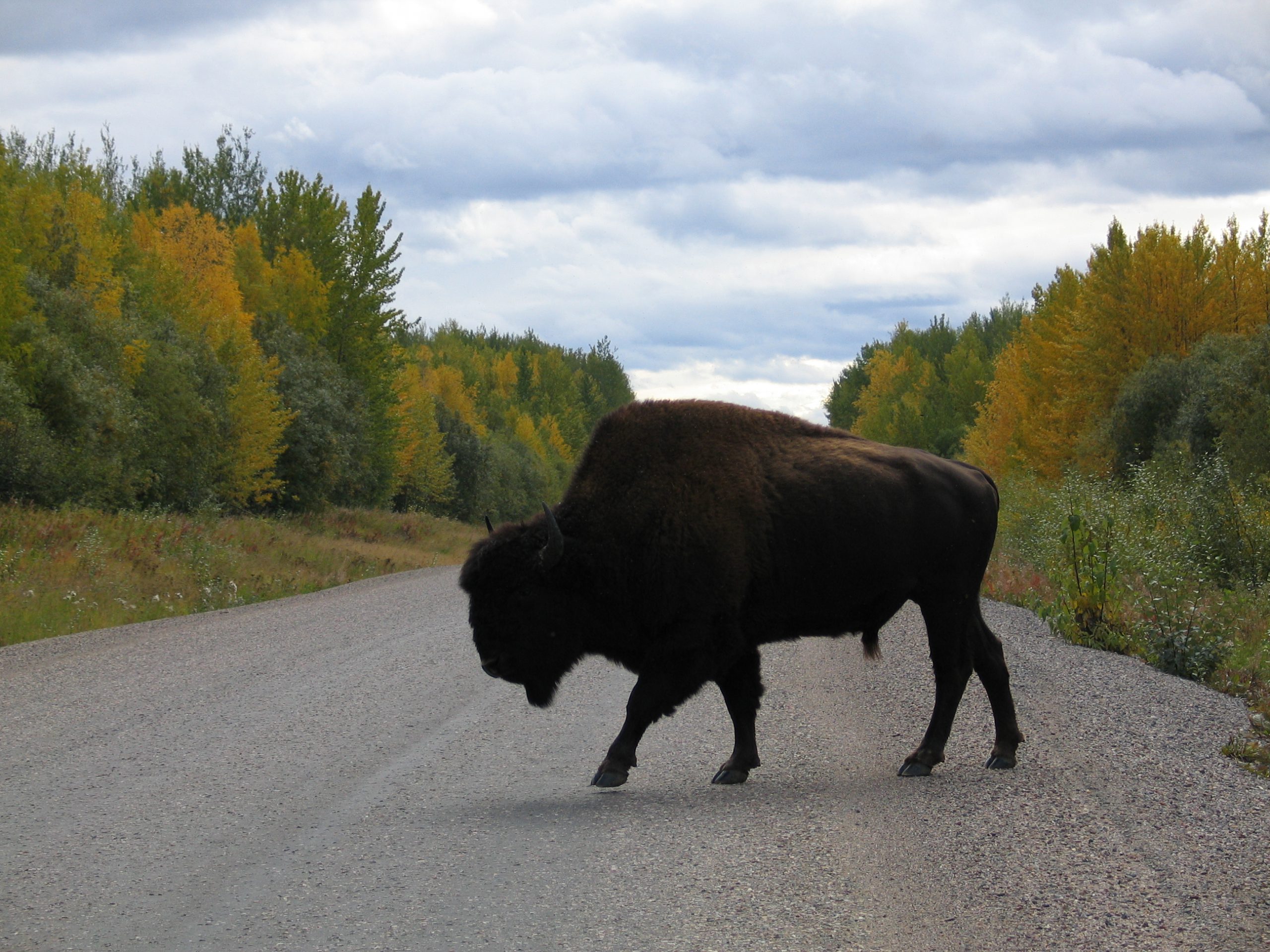
The section of the highway between Muncho Lake and Liard River is famous for wildlife viewing. You might get an opportunity to see Bear, Caribou, Moose, or Bison.

The next stop is a must-see Liard River Hot Springs. These surreal hot springs are the second largest in Canada and offer a relaxing experience in anatural settingof the beautiful lush boreal spruce forest.

Read my other post for more information about Liard River Hot Springs . To stay in the campground, make a reservation between May and September. Reservation takes place through the Discover Camping website .
Part 5: Liard River to Watson Lake
The drive between Liard River Hot Springs and Watson Lake has an abundance of wildlife. You can easily spot moose, bears, and herd of Bisons along the highway. Likewise, this stretch of road offers some spectacular views of the Liard River.

At Historical Mile 627, there is an official BC-Yukon border . After a short drive from the BC-Yukon border, you will arrive at Watson Lake.

Watson Lake is ‘gateway to the Yukon’ . It is the first Yukon community on Alaska Highway. We highly recommend that you should visit the Sign Post Forest , a unique attraction that has more than 90,000 signs installed by visitors from all around the world. Read our other blog post to know more about Watson Lake .

There are a few places to stay such as Historic Air Force Lodge , but we camped at the Watson Lake campground . It is a road accessible Government campground with approximately 40 campsites, and 8 pull-through sites. The campground is very inexpensive, $5 per night.

Before you leave Watson Lake, make sure to fill up your gas and supplies. The next town on Stewart-Cassiar Highway is Dease Lake, which is 257 km from Watson Lake. There is only one First Nations Gas Stations between Dease Lake and Watson Lake. However, when we were driving, they were out of gas. We highly recommend getting gas at Watson Lake.
Highway 37: Stewart-Cassiar Scenic Route
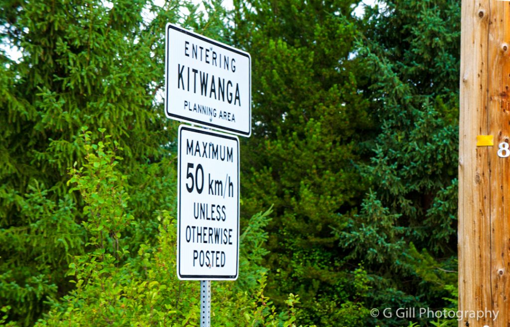
Highway 37 (Stewart-Cassiar scenic route) is a 720 km stretch from Alaska Highway near Watson Lake to Kitwanga, BC.
Note : There is no cellular network on this route and minimal services.

Part 6: Watson Lake to Boya Lake
After exploring Watson Lake, continue west on the Alaska Highway for about 21 km, and turn left onto Highway 37 (Signs for Stewart/ Kitwanga). You will enter British Columbia now, and then enjoy the scenic drive.

Remember to reserve your spot at Boya Lake Campground in advance. We were unable to find any empty camping spots. It was getting late in the evening, so we decided to continue driving south till we come across another campground.
Boya Lake is quite a famous campground. Reservation takes place through the Discover Camping website .
Part 7: Boya Lake to Jade City
We continued driving and arrived at Jade City. Jade City is not a city but a store on the highway that sells jade, rhodonite, hematite products. A TV reality show “Jade Fever” has been filmed here.

We enjoyed visiting the store and bought some souvenirs. The owners of the store allow camping (free of cost) in the lot beside the shop, and offer free coffee in the morning at their store.

Part 8: Jade City to Stewart
We arrived at Jade City in the evening around 6 pm. As we were browsing the store, we met some travellers who were heading northbound on Hwy 37 towards Alaska. They gave an update about the Telegraph Creek Wildfire and informed us that the fire is burning out of control, and authorities were planning to evacuate the town and close the highway that night. We were in a dilemma about proceeding southbound that night before they close the road or camp and try out the next day. Another speculation was that the gas stations are running out of gas because of evacuations and use by wildfire personnel. There is no cellular service to contact anyone or check updates on the internet.
The real dilemma was: if we drive to Dease Lake and find the highway closed, then we won’t have enough gas to return to Watson Lake or just go back to Watson Lake and proceed back via Alaska Highway. The next morning, I informed a friend to listen to me on the High-Frequency radio if I don’t contact him by the evening. We started driving southbound towards Dease Lake via the scenic and smoky highway. Though, it was uncertain and weird feeling as we did not see a single vehicle travelling in that stretch of road. We continued driving!

Finally, we arrived at Dease Lake and found the highway still open. The gas station was busy, and we had to wait for half an hour to get our turn. After getting gas, we were confident about the situation and had enough gas to travel further. The smoke cleared after Dease Lake.
Dease Lake to Kinaskan Lake

After driving about 25 km from Dease Lake, the road gets very scenic and you will arrive at Lower Gnat Lake. Spend some time at this scenic viewpoint.

Continue driving on Hwy 37, and enjoy spectacular views.

Continue driving for about 104 km from Lower Gnat Lake till you arrive at Kinaskan Lake Provincial Park. The park offers spectacular views of the lake and vehicle accessible campsites at the cost of $20 per night.

After spending quality time at Kinsaskan Lake, continue driving on Hwy 37 for about 203 km to Meziadin Junction.
From Meziadin junction take Hwy 37 A to Stewart. The road is very scenic with high mountains. You will also see bear glacier from the road.

Part 9: Stewart to Salmon Glacier via Hyder, Alaska
Stewart is a hidden gem, a beautiful quiet small town surrounded by snow-covered mountains. It flourished in the early 1900s during the gold rush. We highly recommend that you should visit Hyder, Alaska and Salmon Glacier.
Note : There is no American border control or Customs at the Hyder-Stewart Border Crossing . However, there is Canadian border control (CBSA) when you enter back to Canada

Salmon Glacier is the world’s largest road-accessible glacier that is about 40 km from Stewart. Read our blog post about how to get to Salmon Glacier . Our post on Stewart to Salmon Glacier identifies details about self guided driving tour.

Furthermore, read our other post about Hyder, Alaska “the friendliest ghost town of Alaska”.

Highway 16 (Highway of Tears )

Highway 16 or Yellowhead Highway connects Prince Rupert with Alberta. The section of Highway 16 between Prince George and Prince Rupert is also known as “The Highway of Tears.” This name comes because so many Indigenous women and girls have vanished or found dead along this stretch of highway.

Part 10: Kitwanga to Prince George
In Kitwanga, we highly recommend visiting a National Historic Site Gitwangak Battle Hill. Take a walk and follow the self-guided trail to understand the history of the place.
We stopped for lunch in Smithers, and continued driving on Hwy 16.

If you are near Vanderhoof, we recommend visiting Fort St James. It is a beautiful and historic small town located along the shore of a spectacular Stuart Lake. Fort St James is approximately 60 km north of Vanderhoof, the geographical centre of British Columbia. Read our blog post on Fort St James for more details.

We intended to stay near Vanderhoof, but due to extreme wildfire near Burns lake, and too much smoke, we continued driving and went straight to Prince George.

The photographs below are from the 2018 wildfires near Burns Lake. The smoke was so thick that it turned day into darkness.

Useful Links – Great Northern Circle Route
Super Natural BC: Great Northern Circle Route
Boya Lake Campground
Kinaskan Lake Provincial Park
Gikwangak Battle HIll
Thanks for visiting our blog. Please leave a comment if you find our post helpful, or if you have any questions or suggestions for us .

Pat Werbowski
Perfect layout, information, and quantity to inform & interest Thank You

Hello Pat, thank you for visiting and appreciating our blog

Best view i have ever seen !

Like!! I blog quite often and I genuinely thank you for your information. The article has truly peaked my interest.
Thank you so much for appreciating our post. We are so glad that our post peaked your interest. We look forward to hear your experience 🙂

Inderjit Grewal
The super natural ,a gift bestowed to BC due to it’s geographical feature A feel like never coming back from a world so mystic You have given a vivid map of the exploring these places of great interest Keep going.to see the world through your eyes TRUE EXPLORING
Thank you so much for words of appreciation. Your continued support means a lot 🙂
Leave a Reply Cancel reply
Your email address will not be published. Required fields are marked *
Thanks for visiting- G&H

- Budget Travel
- Cheap Flights
- Driving Canada
- Paved Roads
- Gravel Roads
- Train Travel
- Hitchhikers Guide
- Tourist Visa
- Working Holiday Visa
- Hospitality Work
- Organic Farms
- Ranch Jobs in Canada
- Canada Topo Maps
- Climate & Weather
Alaska Highway
- Thompson Okanagan
- Kootenay Rockies
- Cariboo Chilcotin
- Northern BC
- Alberta Rockies
- Southern Alberta
- 19 Best Alberta Towns
- Yukon & Alaska
- Northwest Territories
- Saskatchewan
- Guided Tours 2024/2025
- Camper Rental
- Accommodation
- Travel Insurance
- Basic Packing List
- Campfire Cooking
- Campfire Recipes
- Multi Day Hikes
- Horseback Adventures
- National Parks Canada
- Small Town Rodeos
- Heliskiing Canada
- Canada Facts
- Wilderness Dangers
- Black Bears
- Grizzly Bears
- Polar Bears
- Canada With Kids
- Canadian Food
- Canadian Currency
- Outdoor Store
- Travel Resources
- Backcountry Newsletter
Northern BC Travel Guide
British Columbia’s north is a vast wilderness full of wildlife, pristine glaciers, ancient totem poles and raw rugged splendour.

Epic Highways In Northern BC
Road-tripping in Northern BC is like being in another world. The population decreases and wild animal sightings increase the further north you travel. It gets quieter and more adventurous as the roads get rougher.

Nass Valley AutoTour

Stewart-Cassiar #37

Top Posts BC
Featured towns in northern bc.

Stewart BC / Hyder Alaska

The Hazeltons

25 Best Small BC Towns
Northern british columbia travel guide.
Northern BC Facts
Table of Contents
Northern BC is roughly the top half of British Columbia . It has a size of 500,000 square km and is home to fewer than 500,000 residents. This makes Northern BC one of the least densely populated places in North America. Prince George is northern BC’s largest city.
People who live in northern BC are passionate about their large outdoor playground, its culture and colourful past and are eager to share it with you.
Northern BC has lots of open spaces, long stretches of lonely roads and plenty of hidden treasures for you to discover. You will come across an abundance of Canadian wildlife . What an amazing sight to see a herd of buffalo on the side of the road or a female moose with her baby or stone sheep making their way across cliffs.
It happens to many of us. We travel to far-away places and we don’t know our own country, (or province in my case). I spent many years in the Okanagan Valley and didn’t know what Northern BC was like. For me, northern BC was where people went to find work and made a big buck, just like in Northern Alberta .
Little did I know until I travelled through the northern part of the province on my way to the Yukon for the first time. I soon realized this was unspoiled land and as beautiful as it can get. It’s a land made for wilderness adventure, just the way I like it.
Northern BC – Why You Should Go
If you’re looking for fast wilderness, raw, rugged beauty, rich history, interesting aboriginal culture and authentic people, you came to the right place. Follow the historic trails of the First Nation people, explorers, fur traders, gold seekers, pioneers, railroaders, and lumberjacks. This region of British Columbia has it all.
Once you escape to Northern BC, you might find yourself coming back again and again.

Getting There and Around
Four main highways give access to Northern BC:
- Yellowhead Highway 16 from the Alberta border in the east to Prince Rupert west on the Pacific coast. At Kitwanga you can head north on Highway 37 to Stewart, Yukon and Alaska.
- Alaska Highway 97 north from Prince George to Dawson Creek and the Peace River Country. From there Highway 97 continues north to the Yukon and Alaska.
- Steward Cassiar Highway 37 originates in Kitimat. This north/south route follows Highway 16 for a small stretch before turning north at Kitwanga. From here it continues to its terminus near Watson Lake in the Yukon. Highway 37 A leads to Stewart BC and Hyder Alaska .
- Atlin Highway 7

Prince George is northern BC’s busiest airport and offers frequent scheduled flights to major cities. Smaller regional airports are in Fort St. John, Fort Nelson, Smithers, Terrance/Kitimat, Prince Rupert, Sandspit, and Masset. Air Canada, WestJet, Central Mountain Air, Hawkair, Northern Thunderbird Air, Pacific Coastal Airlines, Harbour Air and many charter companies offer air service.
Via Rail’s Skeena line roughly parallels Highway 16 and connects Prince Rupert to Jasper, Alberta. If you decide to take this scenic route you will have an overnight in Prince George. The train stops here overnight and continues the next morning.
BC Bus North is a new long-haul coach service offering connections between Prince Rupert, Prince George, Dawson Creek, Fort St. John, Fort Nelson and Valemount. This service has a fixed route and schedule.
Greyhound is not operating in Canada anymore.
Prince Rupert is the southern terminus of the Alaska Marine Highway System and a frequent stop for Vancouver and Alaska-bound cruise ships. It’s also the terminus of BC Ferries routes up the Inside Passage from Port Hardy on Vancouver Island and across the Hecate Strait from Haida Gwaii. For BC Ferries information visit www.bcferries.com

Top Activities and Adventure Destinations
Northern BC offers limitless outdoor adventure recreation. The countless lakes, rivers, and streams are ideal for water sports like canoeing, kayaking, sailing, and fishing. Other popular activities during the summer months are horseback riding, golfing hiking, birding, and wildlife viewing.
- Venture out on an ocean kayaking tour along Haida Gwaii (Queen Charlotte Islands), known for its rainforests and First Nations history.
- Join a whale-watching trip from Prince Rupert
- Go grizzly bear viewing at Belarko on the road to Bella Coola.
- Visit Liard River Hot Springs Provincial Park for an unforgettable soak in the natural hot pools.
- Find history at Fort St. James National Historic Site
- Kinuseo Falls at Tumbler Ridge
- For the adventure seeker, there is the gravel road to Telegraph Creek.
- Don’t miss a visit to the border towns of Stewart Canada and Hyder (the friendliest little ghost town in Alaska), and take a self-guided tour up to the Salmon Glacier, Canada’s largest glacier accessible by road.
- The Hazeltons and the Kasan First Nation Village
- Drive the Auto Tour from Terrace to Nass Valley and Nisga’a Memorial Lava Bed Park
- 25 Best BC Towns to Visit – check out the selection of unique small towns in British Columbia
Communities In Northern BC
The main communities to visit in northern BC include Prince Rupert, Terrace, Smithers, The Hazeltons , Stewart , Houston, Burns Lake, Fort St. James, Vanderhoof, Prince George, Fort St. John, Dawson Creek, Tumbler Ridge, and Fort Nelson. Read more: Alaska Highway .
Read more: 25 Best Towns in British Columbia to Visit

RELATED LINKS
Thompson Okanagan Travel Guide
Kootenay Rockies Travel Guide
Cariboo Chilcotin Travel Guide
Alaska Highway Travel Guide
TOP POSTS about British Columbia
Hiking Secrets
How to get around Canada
Backcountry Accommodation

- Prestige Adventures
- Dog Friendly
- Go Green Program
- JoeAnnas House
- Book Direct Perks
- Nelson - Inn
- Nelson - Resort
- Prince Rupert
- Prince George
- Business Travel
- Meetings and Events
- Corporate Getaway
- Third-Party Credit Card
- Rewards Program
- Request a Prestige Rewards Card
- Rewards Partner Application

RESERVATIONS
Your guide to the ultimate northern bc summer road trip wednesday, july 26th, 2023 by prestige hotels & resorts.
Summertime means road trip time! Whether you are coming to Canada from abroad or taking the time to get to know your home country, it is well-known that one of the best ways to enjoy the breathtaking views of British Columbia is by taking a drive down a country, mountain, or lakeside road. BC is a huge province, and we know it can be overwhelming, but don’t worry! Here’s your guide to the ultimate Northern BC summer road trip!
Northern British Columbia
Prince george – smithers – prince rupert.
Welcome to where the wild things are. Northern British Columbia is a vast, untamed paradise that beckons you with its rugged wilderness, captivating coastal beauty, and unforgettable experiences. Here nature reigns supreme, inviting adventurers to explore its pristine landscape. From the untamed wilderness of the inland forests to the breathtaking allure of the coastal regions, Northern BC is a land of diversity and contrasts. Adventure awaits!
There are more trails than we could ever list, more local dining gems than we could ever recommend, and so many unique experiences that we couldn’t even cover half of it. That being said, we did our best. Here’s the ultimate Northern BC road trip. Prepare for a road trip that combines cultural richness, outdoor adventures, and good old northern hospitality!
Ultimate Northern BC Summer Road Trip Day One: Prince George
Begin your exploration by delving into history at the Exploration Place Museum and Science Centre . Discover fascinating exhibits that showcase the region’s Indigenous cultures, natural history, and modern achievements, all providing insight into Prince George. The Exploration Place Museum and Science Centre takes great pride in promoting education on Indigenous cultures, including the Lheidli T’enneh community that has called the Prince George area home since time immemorial. Through its exhibits and programs, the museum offers a unique opportunity to learn about the rich heritage and traditions of local Indigenous communities. Visitors can delve into the First Nations people’s history, art, language, and spiritual beliefs. Interactive displays, storytelling sessions, and artifacts provide a comprehensive understanding of Indigenous cultures, fostering respect and appreciation for their contribution to the region.
Outdoor enthusiasts may opt to spend the whole day deep in the woods. Prince George has an abundance of that! Immerse yourself in the pristine wilderness of nearby parks and trails, where hiking, mountain biking, and wildlife viewing await. Explore the tranquil waters of Nechako and Fraser Rivers, perfect for canoeing, kayaking, and fishing amidst the serene surroundings.
Lunch is the first opportunity you have to indulge in the rich flavours of the north! Savour locally sourced delicacies, wild game dishes, and crafter brews that reflect the essence of the region’s bountiful options. When it comes to savouring not just exceptional beer but also mouthwatering meals, Crossroads Brewing Company is the ultimate destination. With its exceptional range of brews and delectable menu, this renowned establishment is sure to satisfy your cravings for both incredible beer and delectable cuisine.
The afternoon is for the arts! Two Rivers Gallery is a vibrant center of the arts that has been serving the community for nearly 20 years. The gallery not only encourages artistic expression but also promotes diversity and cultural understanding. With thought-provoking exhibits, Two Rivers Gallery often features Indigenous art as a part of its collection. Visitors can expect to encounter a range of Indigenous works, including traditional and contemporary pieces that highlight the rich cultural heritage of the Indigenous communities in the region.
Locals at Prestige is the hot new restaurant in Prince George, a sophisticated eatery emphasizing fresh, local, and sustainable ingredients. You’re sure to be impressed. Did you know Prestige Treasure Cove Resort is directly connected to Treasure Cove Casino ? You’re in for a fun evening! Treasure Cove Casino has over 37,000 square feet of gaming fun. Try your hand at one of the table games, bingo, or one of the 500 slot machines. Yes, we said 500!
Ultimate Northern BC Summer Road Trip Day Two: Smithers
The drive from Prince George to Smithers offers a picturesque journey through the stunning wild world of Northern BC. The drive takes approximately four and a half hours, depending on traffic and road conditions. Stock up on your favourite road snacks and drinks and prepare to soak it all in. You’ll start by heading west on Highway 16, also known as the Yellowhead Highway. This highway is well known for seeing all sorts of wildlife, so keep your eyes peeled! You never know when you may see a mother bear and her cubs crossing the road. Along the way, you’ll pass throwing charming small towns, dense forests, rolling hills, curving rivers, notable lakes, and breathtaking mountain vistas.
Smithers is where an outdoor adventure and angler’s dreams come to life. Set against a breathtaking backdrop of snow-capped mountains and pristine rivers, Smithers is a haven for fishing enthusiasts seeking an unforgettable angling experience. Head out with Steelhead Excursion and cast your line into the bountiful waters of the Bulkley River, renowned for their abundance of salmon and steelhead. Whether you’re a seasoned angler or a first-time fisherman, you will have a thrilling day on the water!
You’ve had a long day of outdoor adventure! Time for a satiating dinner and some evening entertainment. Noir Kitchen and Bar , located at Prestige Hudson Bay Lodge Smithers , has a host of European-inspired meals offering a Mediterranean dining experience in Smithers. After your delectable meal, you’ll head to a little timber-framed brewery known as Smithers Brewing Co . With a total of ten taps; there’s plenty of variety. They also have cider and in-house brewed non-alcoholic Kombucha. There’s something for everyone! On some nights, the brewery has amazing live local talent performances. Enjoy the northern melodies of local artists while you sip some locally inspired brews!
Ultimate Northern BC Summer Road Trip Day Three: Prince Rupert
Your journey resumes back on the Yellowhead Highway. Smithers to Prince Rupert is roughly three hours and fifty minutes of winding roads through stunning landscapes. The drive will take you through lush forests, where towering trees create a dense canopy of green. Majestic mountains stand guard proudly in the distance, with their peaks reaching into the clouds. The Yellowhead Highway meanders alongside pristine rivers and crystal-clear lakes, reflecting the vibrant colours of the surrounding wilderness. As you approach Prince Rupert, the scenery transforms into a coastal wonderland with rugged cliffs, crashing waves, and panoramic ocean views.
When you arrive in Prince Rupert, head to Cow Bay to get a feel for the community along with some delightful ocean scenes. You’ll find yourself transported to a bygone era with its historic buildings and coastal cobblestone streets. This quaint district is a haven for art enthusiasts, offering a plethora of galleries, studios, and boutiques showcasing local talent. Indulge your taste buds with some delicious seafood for lunch at one of the waterfront restaurants. With its unique blend of history, culture, and natural beauty, Cow Bay is a must-visit destination that will leave you with lasting memories.
Get ready to step into a journey through time at the North Pacific Cannery , where history comes alive amidst the rugged beauty of the North Coast. As you enter, a sense of historical anticipation fills the air as you imagine an era when salmon canning was the heartbeat of this community. Firstly, immerse yourself in the rich heritage of the cannery through a guided tour. Step by step, your knowledgeable guide will unveil the secrets of this once-thriving industry, weaving together tales of hardworking fishermen, bustling canning lines, and the resilience of the people who called this place home.
Next, weave your way through the meticulously preserved buildings, each a testament to the ingenuity and craftsmanship of a bygone era. Wander the boardwalks, tracing the footsteps of fishermen past and let the echoes of the past whisper stories in your ears. The scent of saltwater mingles with the tang of freshly cut timber, a reminder of the relationship between the cannery and the surrounding coastal wilderness.
We totally understand if you want seafood for dinner. After all you’re in the best place for the freshest selection, and you should take advantage of that! If you’re looking for something else check out OV Burger Bar : no fuss here, just high-quality ingredients and big flavours. It’s a quick drive or an enjoyable walking distance from Prestige Prince Rupert Hotel . In the summer months, Prince Rupert has a very late sunset. Let’s make the most of it! Rent a kayak and head out along the coast, getting a special view of the rugged coastline. Immerse yourself in the tranquility of nature as you navigate through hidden coves and explore secluded beaches. Encounter diverse marine life, from playful seals to majestic eagles soaring overhead. With each stroke of your paddle, you’ll forge a deeper connection with the untamed wilderness that Northern BC is known for.
Comments are closed.

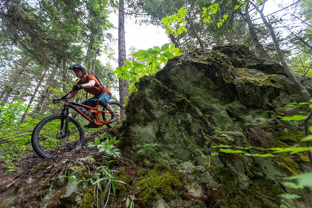
It is important to respect other trail users and support the organizations that maintain the trails where ever you ride.
Tips on how to ride safely and responsibly .
8-Day Itinerary: Northern BC Road Trip
8-Day Itinerary: Northern BC Road Trip
This 8-day itinerary is based on the Northern BC trip experienced by one of our lucky contest winners. It features 8 stops that could be spread out over 2 weeks or more to really experience what the region has to offer.
Access: Start in Williams Lake | End in Terrace
Total duration: 8 Days (or more)
Total distance: 800 kilometres (497 miles) See route in Google Maps
Follow this itinerary for a real taste of what Northern British Columbia has to offer. Travel from Williams Lake to Terrace, visiting small riding communities with remarkable trails.
Day 1: Williams Lake
Discover the riding options on more than 200 km of trail within the city limits. Enjoy lakeside laps on Fox Mountain or South Side before cooling off with a jump in the lake. Head for the Desous trail network south of town.
Day 2: Quesnel
Explore Dragon Mountain and Wonderland trail networks. Make sure to sample some of the local brews at Barkerville Brewing .
Day 2: Prince George
Explore Pidherny Recreation Site north of town. Ride 60+ trails surrounding the University of Northern British Columbia. Get some post-ride fuel at Butella Burning , CrossRoads Brewery , or Trench Brewing & Distilling
Day 3: Fort St. James
Check out the must-ride experience of Mount Pope Trail . Spend the rest of the day exploring the trails in Mt. Pope Provincial Park . Stay overnight at lakeside Stuart Lake Provincial Park .
Day 4: Burns Lake
Spend ample time exploring the trails of Boer Mountain . Camp beside the trails at Kager Lake . Tackle the 13.8 km Razorback trail .
Day 5-6: Smithers
Explore the 22.1 km epic Cronin Pass route through Babine Mountains Provincial Park. Check out the plane crash gap jump in the Piper Recreation Area . Dine at the Alpenhorn Bistro and Bar
Day 7: Terrace
Just outside of town, enjoy shuttle laps on Copper Mountain . Ride the trails close to downtown at Terrace Mountain . Camp at the Ferry Island Municipal Campground .
Cookies are used to make this website work and to enhance your experience. You can provide consent by clicking the "I Accept" button.
Cookies are used to make this website work and to enhance your experience. To learn more about the types of cookies this website uses, see our Cookie Policy. We need your consent to use marketing cookies. Marketing cookies are used to track visitors across websites. The intention is to display ads (via third party services) that are relevant and engaging for individual users. Please select the checkbox below to indicate your consent.
Northern BC Road Trip – Getting to and Along the Alaska Highway
Northern B.C. is the place to drive in summer for long daylight hours, unspoiled wilderness and unlimited fishing, hiking and outdoor enjoyment. It also offers routes to the Yukon and Alaska – including the famed Alaska Highway – a highlight-of-a-lifetime road adventure.
Here are some tips for motoring to the Alaska Highway and up the historic highway itself, to the Yukon. We’ve got a few points of interest for you, including B.C. provincial parks, which accommodate recreational vehicles. Once you’re onto the Alaska Highway, north of Fort Nelson, you’re getting into wilderness, so note the section further below for information about gas stations, rest areas, camping and some of the steeper hills.
Note: The parks and attractions named below are a few highlights only. For more details, check out BC Parks and TourismBC . Keep in mind, while looking at maps, that Highway 97 is also called the Alaska Highway, as it travels north from Dawson Creek . Facilities and services can change over time, so you may wish to check with local visitor centres.
Tips for Travelling North
Stay on top of road conditions and construction activity while travelling by visiting DriveBC on your laptop or mobile. Note that from Fort Nelson northward, internet connectivity is limited or unavailable.
Should an emergency arise while you are in the Pink Mountain area, or any further north, don’t dial 911. (The 911 service is not available there). Instead, call Northern Rockies RCMP (250) 774-2777, BC Ambulance Service (250) 774-2344 or Northern Rockies Fire Rescue (250) 774-2222.
Watch for wildlife – the north has many species of animals that could cross your path.
Turn on your headlights in the day whenever visibility is poor – for example in rainy or dusty conditions. Most vehicles have daytime running lights but when you turn on your headlights, you’ll be easier to see from behind.
Getting to Dawson Creek, BC. – Mile 0 of the Alaska Highway
From Grande Prairie, Alberta (Two Routes)
West, Then North – take Highway 43 west and once you’re into B.C., the road becomes Highway 2 – the Dawson Creek-Tupper Highway. This route passes Swan Lake Provincial Park and Pouce Coupe, then enters Dawson Creek, Mile 0 of the Alaska Highway.
North, Then West – take Highway 2 north, then turn west onto Highway 49. Shortly after arriving in B.C. you’ll get to Dawson Creek, Mile 0 of the Alaska Highway (Also known as Highway 97).
Another option from Grand Prairie is take Highway 2 north, pass the turnoff to Highway 49, then turn onto Highway 64. Highway 64 travels north then heads west, and once over the B.C. border, the route becomes Cecil Lake Road. Turn left onto Rose Prairie Road, which will take you onto and through Fort St. John. Keep driving through town and you’ll find yourself on Mile 45 of the Alaska Highway.
From Prince George , B.C. via Highway 97
Head north on Highway 97 from Prince George and drive 402 kilometres to Dawson Creek. Along the way there are some beautiful provincial parks.
Whiskers Point Provincial Park has lakeside camping and lots of activities for children.
Pine Le Moray Provincial Park features peaceful camping beside Heart Lake, among the rugged Hart Ranges of the Rocky Mountains. (How could you not love this place?)
Moberly Lake Provincial Park offers swimming and fishing in the lake and has an information kiosk about the area’s history, flora and fauna.
Side Trip – Tumbler Ridge Geopark
This UNESCO Global Geopark is recognized as having internationally significant geological heritage. Palaeontology, geology and human history are all featured, with opportunities for hiking and driving tours.
At Chetwynd, head south on Highway 29 to Tumbler Ridge and the geopark. Once you’ve explored the geopark, if you take Highway 52 back north to Highway 97, you’ve made a circle route.
This is it!! – Dawson Creek – Mile 0 of the Alaska Highway
Driving the Alaska Highway is not the challenge it once was, years and years ago. (Ever seen those “ I Drove the Alaska Highway and Survived ” bumper stickers?) The road is now fully hard-surfaced, and over time more services have become available – but be aware that some gas stations can be far between.
Dawson Creek is an excellent place to start your Alaska Highway journey and get information about campgrounds and gas stations along the Alaska Highway, so be sure to stop by the visitors centre to help plan your route. The town also has the Alaska Highway House which depicts the route’s rapid construction by 30,000 U.S. soldiers, along with Canadian civilians, during the Second World War.

The Alaska Highway – Dawson Creek to Fort St. John
Kiskatinaw Provincial Park is a short walk from the Kiskatinaw Bridge , built by the U.S. military, as part of the Alaska Highway. The 30-metre high bridge was the first curved wooden bridge built in Canada and is the last curved, banked trestle bridge standing in Western Canada.
The Alaska Highway – Fort St. John to Fort Nelson
Charlie Lake and Beatton provincial parks both offer swimming, fishing, hiking and boating and are located on either side of Charlie Lake.
Mile 80 Rest Area is the last provincial rest area heading northward. Located by a river it has running water (not potable) and flush toilets. Check the nearby overhead message sign, for any road conditions further up the highway.
Sikanni South Hill – Grade: 9% (three kilometres)
Sikanni North Hill – Grade: 8% (two kilometres)

South Taylor Hill – Grade: 6-10% (five kilometres)
Buckinghorse River Wayside Provincial Park is east of the foothills of the Rocky Mountains and is known for grayling fishing.
Andy Bailey Regional Park and Campground has 12 un-serviced campsites, eight tent sites and a launch for non-motorized boats – a great place to picnic in a forested setting or for a quick fishing adventure.
The Alaska Highway – Fort Nelson to Watson Lake
Tourism Northern Rockies is a great information source for Fort Nelson area and further north, and has a travel guide about private accommodations and regional parks, including Tetsa River Campground.
Fort Nelson Visitor Information Centre near the Fort Nelson Museum offers free wireless internet service, and the latest information. This is the last TourismBC visitor centre for the rest of the Alaska Highway.

Steamboat Hill – Grade: 8% (two kilometres)
Stone Mountain Provincial Park provides spectacular views of the Northern Rockies (hence the park’s name) and a good likelihood of spotting wildlife.
Summit North 1 Hill – Grade: 8% (two kilometres)
Summit North 2 Hill – Grade: 6% (1.7 kilometres)

Muncho Lake Provincial Park is close to the highway and has two campgrounds near the 12-kilometre lake.
Liard River Hot Springs Provincial Park is open all year long for northern travellers to soak and relax. Visitors reach the hot pools via a boardwalk which passes through boreal forest and a warm water swamp.
Hyland River Provincial Park is the last provincial park along the Alaska Highway, before the Yukon border.
Watson Lake, Yukon has full services and repairs and is the junction to new routes.
Want to See Even More of Northern B.C.?
The Great Northern Circle Route links the Alaska Highway to Watson Lake, Yukon, with the scenic B.C. Highway 37 – the Stewart Cassiar Highway . The 725-kilometre route is hard-surfaced, with the exception of one kilometre of gravel, and has three provincial parks with RV camping. Fascinating side trips include Highway 37A to Stewart, touring through the Yukon to reach historic Atlin, B.C., and travelling Telegraph Creek Road as it follows the Stikine River through dramatic canyons, to reach the community of Telegraph Creek.
If you’ve been hankering to see B.C.’s other northern neighbour, there’s the Deh Cho Travel Route where B.C. Highway 77 spurs off the Alaska Highway north of Fort Nelson, B.C., and goes through part of the Northwest Territories, then back south to Alberta.
Going Further Along the Alaska Highway?
You might want to look into the Milepost , which has guided travellers along the route since 1949, and is updated annually.
Northern B.C. highways take you to remote places of breathtaking beauty and historic significance. The Ministry of Transportation and Infrastructure is pleased to contribute to safe passage for all modern-day explorers.
Page 1 of 10 comments on “Northern BC Road Trip – Getting to and Along the Alaska Highway”
Leave a comment cancel reply.
You must be logged in to post a comment.
my husband and I are planning to go from kitwanga to fort saint john..pulling our 35 fot trailer is this highway okay for that?
Thanks for your question. Yes, BC Highway 16 and 97 are paved and regularly support large commercial vehicles. We encourage you to check DriveBC before you leave to get a better sense of current conditions and events along the route. Safe travels.
List of gas stations between Ft Nelson and Watson Lake, please
Thanks for connecting with us here. Unfortunately, we don’t keep a list of this kind, but it should be easy to find info like this with a quick google search. Good luck and happy trails!
I am planning/researching a trip to Telegraph Creek from Scotland possibly travelling May or early September 2016. Can you advise road conditions on Highway 37 & Highway 51 down into Telegraph Creek. I would be hiring a 4×4 for the trip. Any potential hazzards I should be aware of? Any advice would be most welcome. Thanks Anne
Hello Anne, Sounds like an exciting trip. The road to Telegraph Creek is gravel and should be driven with caution as there are switchback and steep cliffs, but in a 4×4 in May or September the weather should be fine. You might ask the 4X4 rental company for some tips, or search out a local forum for tips closer to the date? Happy trails!
I am going to alasks on motor cycle are the roads good to travel and do I need to carry extra gas.
Hi Ken, I’d recommend you check drivebc.ca/mobile. It’ll give you an indication of how much construction is planned for that trip. Here’s the link to look at events on Highway 37: http://drivebc.ca/mobile/pub/events/Highway37.html And here’s the webcam views along that route: http://drivebc.ca/mobile/pub/webcams/Northern37.html And is it ever a bad idea to take extra gas?
My wife and I are going to drive the Alaska highway next year in the summer. My car uses 91octane gasoline. Is that high of octane available in British ColumbiaAnd the Yukon on the Alaska Highway?
A quick scan of 91 octane search results shows us that octane should be available to you on your journey. But to be extra sure, you might want to double check at specific points along your planned route.
- Search Please fill out this field.
- Newsletters
- Inspiration
Planning the Ultimate British Columbia Road Trip
Kevin Miller / Getty Images
British Columbia (BC) is the westernmost province in Canada, bordered by the Pacific Ocean on one side and the Rocky Mountains on the other. In addition to mountains and coastline, forests dominate British Columbia's geography, creating a diverse and beautiful landscape to traverse by road trip.
Since the northern portion of British Columbia is largely unpopulated, extremely mountainous, and underdeveloped, the ideal tour would stick primarily to the province's lower portion. The two best options are to drive a loop from Vancouver, hitting the charming mountain villages that dot the Rocky Mountains along the way, or to spend your time touring Vancouver Island, known for its untamed, surf-centric beaches.
BC roads are, for the most part, well-maintained, safe, and clearly marked, but some routes are winding and mountainous. Visitors should be aware of weather conditions, especially between late October and April when snow, fog, and ice can affect the roads. Driving through the Rocky Mountains during this time is not advisable for inexperienced winter drivers.
Always check the weather forecast and the road report before traveling. For information on current road conditions, visit the British Columbia Ministry of Transportation .
Basic Rules of the Road
Getty Images
Driving in Canada is very similar to driving in the U.S. Canadians drive in the right lane, like Americans, but they measure distances in kilometers instead of miles. Consider these regulations:
- Drivers may not use hand-held electronic devices while driving. Talking on the phone or texting could earn you a ticket for distracted driving, which can cost upwards of $350.
- International visitors may drive in BC for up to six months with a valid driver’s license from your country.
- Driving under the influence of any substance, such as alcohol or drugs, is illegal, even though marijuana products are legal throughout the province.
- Seat belts and car seats appropriate for the age and size of your child are mandatory.
- Common speed limits in BC include 30 kmh (20 mph) in a school zone; 50 kmh (30 mph) in built-up areas; 80 kmh (50 mph) on rural roads; and 110–120 kmh (70–75 mph) on major highways and expressways. The maximum speed limit in BC is 120 kmh (75 mph).
Planning the Logistics
If you plan to fly into Canada and rent an RV or car for your road trip, the most logical place to start is either in Calgary in the neighboring province of Alberta or in Vancouver. Seattle , a two-hour drive away from the Canada/U.S. border, would also be a convenient takeoff point for a drive around British Columbia. Flying into the U.S. instead of Canada can sometimes be more convenient or affordable.
Calgary is a major airline hub that's about 118 miles (190 kilometers) from the BC border. If you arrive in Calgary and rent a car, you can make a splendid drive to Vancouver via Banff and Lake Louise, two of Canada's most stunning mountain destinations.
Camping is also an excellent option for accommodation during your trip; campgrounds in British Columbia are abundant and range in service level, from pit toilets and hand-pumped water to full washrooms with hot showers and electricity. If you plan to stay in hotels and lodges, it would be best to book far in advance, especially for summer.
Option 1: East of Vancouver Loop
Jenske Arts / FOAP / Getty Images
This trip option, east of Vancouver, can take between five and 10 days, depending on whether you include the eastern cities of Revelstoke and Golden in your itinerary. In any case, you'll first want to get from Vancouver to Whistler along the stunning Sea to Sky Highway (Highway 99). This 750-mile (120-kilometer) route is extremely scenic, offering ocean views to one side and mountain panoramas to the other. At the end of it is the famous ski destination—Whistler—one of the best in the world and home to two mountains, Whistler and Blackcomb, that hover a mile above the village.
From Whistler, head northeast to Kamloops , (a four-hour drive). You'll see the terrain change from coastal mountains to near-desert. Worthwhile stops along the way include Nairn Falls Provincial Park, Pemberton, and Lillooet. The latter two towns were a hub of Gold Rush activity in the 19th century and are steeped in First Nations (indigenous) culture. But instead of staying in Kamloops, continue an hour past—still on the TransCanada Highway —to Salmon Arm, which is far more charming.
If you have the time, continue east to Revelstoke and Golden, two of BC's most beautiful destinations in the Canadian Rockies and home to some epic ski resorts. In this region, you can visit hot springs and provincial parks whose lakes are full of that azure-blue glacial water that Lake Louise is known for. Because of the mountainous terrain and limited roads, you'll likely want to head back the same way you arrived, on Highway 1. On the return, stop by places you might have passed the first time around, like Craigellachie and Sicamous, both sleepy-but-scenic resort and retirement towns.
At Sicamous, head south to Kelowna (a two-hour drive), also known as the gateway to the Okanagan Valley and its wine region. Sporty travelers love the wide array of outdoor activities here: hiking, golfing, boating, and more. From there, drive down through Penticton to Osoyoos, stopping at any winery that appeals to you. Mission Hill and Quails Gate are two of the better known and visually striking wineries, but there are dozens of others. You're now on the way back to Vancouver along the very southern part of British Columbia. From Osoyoos, hop onto Highway 3, through Hope and then on to Vancouver, about a four-and-a-half-hour drive.
Option 2: Vancouver Island
Known for its rugged, diverse, and beautiful geography, moderate climate, and unhurried way of life, Vancouver Island sits just off the mainland of British Columbia. It's home to the provincial capital of Victoria, but not the province's most populous city, Vancouver. Vancouver Island is fairly big, requiring about six hours to drive from its south end to its north end. It takes three hours to drive from Nanaimo (mid-island on the east) to Tofino (mid-island on the west) alone.
Victoria makes for a great stopover, with Butchart Gardens beckoning a half-day tour and Craigdarroch Castle requiring at least a few hours. There are plenty of museums to explore and whale-watching tours departing from here, too. After staying in Victoria for a night or two, road trippers can continue to Parksville (about a two-hour drive away) for sprawling, sandy beaches, then proceed for three hours to beautiful Tofino, a small coastal town with a major surf culture.
The hippie-ish town of Tofino is brimming with forests, trails, and beaches (that are slightly cold for swimming, but stunning nonetheless). It offers a diverse culinary scene and activities such as whale watching, black bear viewing, and sea kayaking. End your trip at the picturesque fishing village of Telegraph Cove or Port McNeill for a grizzly bear safari.
Related Articles
More related articles.
CELL COVERAGE LAYER
See where you can dial 911 and scope out data for (really) remote work with Gaia GPS.
BEST WEEK EVER
Try out unlimited access with 7 days of Outside+ for free.
Start Your Free Trial
Powered by Outside
The Most Epic Road Trip in North America
Immerse yourself in awe-inspiring landscapes, geological wonders, and cultural experiences closely tied to the land in the great wilderness of northern british columbia.
Destination British Columbia
- Share on Facebook
- Share on Reddit
Massive in scale and steeped in Indigenous cultures that go back millennia, the far north of British Columbia is unlike anywhere you’ve ever experienced. These vast otherworldly landscapes call to those who seek a deeper connection to nature. From geothermal hot springs and ancient lava beds to one of the largest glaciers in Canada, you could spend a lifetime adventuring in this remote region, known as The Great Wilderness , and there will always be more to see and learn.

Whether you have a few days or a couple weeks to explore, the Great Northern Circle Route is a great place to start. This 1,981-mile loop connects the Stewart-Cassiar (Hwy. 37), Yellowhead (Hwy. 16), and Alaska (Hwy. 97) highways on a journey packed with natural wonders and community immersion. Connect with the histories and living cultures of more than 50 distinct First Nations who have been caretakers of these spectacular landscapes from the start. Traverse rolling prairies, hike through boreal forests, and witness incredible biodiversity. Starting from Prince George—where direct flights from Vancouver and six other airports in British Columbia and Alberta easily connect travelers to all the grandeur The Great Wilderness has in store—here are just some of the once-in-a-lifetime experiences that await you in the far north of British Columbia.

Spot Awe-Inspiring Wildlife
In an area as vast as The Great Wilderness , wildlife encounters could happen in many places, but a few spots stand out for animal activity. Enormous even by The Great Wilderness standards, the 25,000-square-mile Muskwa-Kechika Management Area is a haven for subarctic species, including moose, elk, plains bison, grizzly bears, Stone’s sheep, and northern mountain caribou. This uniquely managed area, in the traditional territories of the Kaska Dena, Treaty 8, and Carrier-Sekani, aims to balance conservation and responsible land use based on centuries of Indigenous wisdom and teachings. Because the area has limited road access from the Alaska Highway, wildlife lovers will get the most out of a visit to Muskwa-Kechika’s ancient mountain ranges, alpine meadows, and river valleys with a multiday backcountry experience. Access Muskwa-Kechika by floatplane, then travel by foot, horseback, or canoe to explore routes that crisscross this remote wilderness. If it’s your first time in the backcountry of northern British Columbia, book a guided trip. Knowledgeable local outfitters can help you safely and respectfully spot a range of wildlife in the area.

Soak in a Natural Hot Spring
Those with ancestral roots in the Liard River area—people speaking the Athapaskan and Kaska languages, with original groups including the Beaver, Sikanni, Nahanni, and Dog Rib—have understood the therapeutic benefits of geothermal energy for thousands of years. Experience the calming effects of soaking in naturally heated mineral-infused water yourself at Liard River Hot Springs Provincial Park , the second-largest hot springs in Canada. Tucked into a spruce-filled boreal wetland, the hot springs complex consists of eight natural springs, including a rustic pool built for soaking in 108-degree water.
After your soak, wander along the boardwalks to explore this unique ecosystem. The area’s geothermal activity attracts more than just human visitors. Keep an eye out for unique flora and fauna, including massive moose, which frequent the area year-round to graze on aquatic vegetation, tiny chub that thrive in warm water, and 14 varieties of orchids.

Learn from the Gitxsan People
The Great Wilderness offers many opportunities to connect with communities who have stewarded this land for thousands of years. Foster your understanding and appreciation of the enduring legacy of the Gitxsan people at the ‘Ksan Historical Village and Museum . Located at the confluence of the Skeena and Bulkley rivers, the replica village gives visitors a chance to see Gitxsan traditions firsthand. Listen as practiced storytellers share oral histories of the Gitxsan culture, spiritual beliefs, artistry, and social structures. Take a peek inside traditional Gitxsan and Wet’suwet’en longhouses. Then see intricate totem poles up close and watch traditional totem carvers at work.

See How Glaciers Shaped the Landscape
The topography of The Great Wilderness is deeply connected to glacier activity over thousands of years. Get an up-close look at the massive scale of glacial ice at the Salmon Glacier , located 25 miles northwest of Stewart, British Columbia. As the fifth-largest glacier in Canada and the largest vehicle-accessible glacier in the world, the Salmon Glacier offers a chance to fully appreciate the grandeur of these ancient ice giants. Stop at the Stewart Visitor Center for details on road conditions before heading out on a 23-mile drive along the unpaved Granduc Road (Salmon Glacier Road), passing dense forests and historic mining camps along the route. Near mile 17, stop at the glacier’s toe, where you can hop out for a closer look and a photo. Then continue on to the upper viewpoint at about 4,000 feet.

Note: The road to access the Salmon Glacier from Stewart crosses into Alaska before returning to the high point of the glacier in British Columbia. You can find border-crossing information here .
Ready to trade your day-to-day for a journey into these extraordinary landscapes? On the Great Northern Circle route, you can feel the heartbeat of The Great Wilderness and learn from those who have shaped this diverse and magnetic area. Get more details on the adventures above and countless other ways to experience the captivating The Great Wilderness of northern British Columbia at HelloBC.com .
Journey into The Great Wilderness, the northernmost area of British Columbia, Canada, where adventures await curious wanderers. Immerse yourself in a place where Indigenous culture is deeply rooted in the vast lands, an extraordinary landscape of jagged mountains, glittering glaciers, booming waterways, and diverse wildlife. Learn more at HelloBC.com .
Continue Exploring British Columbia
Journey Into The Great Wilderness
Ski the Best-Kept Secrets in British Columbia, Canada
Popular on Backpacker
Join Outside+ to get access to exclusive content, 1,000s of training plans, and more.
© 2024 Outside Interactive, Inc
Great Northern Circle Route
From the rolling prairies and wide-open skies of Peace River Country to the untamed sweeping strata of the Northern Rockies and through lush boreal forests and azure-hued lakes of the Stewart-Cassiar, the Great Northern Circle Route is a quintessential RV bucket-list adventure.
Experience rich culture, colourful locals and outdoor adventure while taking in unique geographic wonders teeming with wildlife (caribou, bear, bison and sheep can all be spotted along the highway).
Both provincial parks and private campgrounds abound, yet with over 1,800 km of highway to travel through some of the most untouched wilderness in the world, this circle route is anything but crowded. If wide-open spaces, majestic vistas and a connection to nature is what you’re looking for, look no further than the Great Northern Circle Route.
Flying in to Prince George, BC or Whitehorse, YT? Check out these RV Rentals: Fraser Way RV , and Go North RV Rental in Whitehorse
Some areas along this route are rural and remote, be sure to check Know Before You Go and DriveBC for up to date information.
PRINCE GEORGE
Start your trip in Prince George , a city on the edge of wilderness, perched at the crossroads of Highway 16 (Yellowhead) and Highway 97, where the Nechako River meets the mighty Fraser.
Known as the gateway to the North, Prince George has seen a boom of culture in recent years, with the welcome surge of young entrepreneurs leading to an upswing of unique restaurants, galleries, and live music venues, not to mention two local breweries, Trench (named after the Rocky Mountain Trench) and the aptly-coined Crossroads Brewing. Prince George is also home to BC’s northernmost winery, Northern Lights Estate winery, specializing in locally harvested fruit wines.
Of course, Prince George is also known for its easy access to wilderness. With hundreds of hiking and mountain biking trails, lakes and rivers at its doorstep, it’s not hard to stretch your legs and immerse yourself in nature here. Be sure to check out the tree carvings at Cotton Wood Islands park, or the accessible trails at Forests for the World or the Great West Life Mobility Nature Trail. Drive an hour east of town to the Ancient Forest/Chun T’oh Whudujut Provincial Park to marvel at giant old-growth cedars in the only inland temperate rainforest in the world.
With nearly a dozen RV parks, campgrounds and provincial parks in and around town, Prince George is a perfect launch pad to stock up, sample a few restaurants, take in an afternoon at the farmers’ market or even a round of golf before embarking northward. To plan a perfect weekend in Prince George, and for a full RV and campground listing, visit Tourism Prince George .
PINE PASS TO PEACE RIVER COUNTRY
As you head north across the continental divide and into the Pine Pass, take a detour down Highway 39 and visit Mackenzie where the road less travelled, isn’t always a road! With Morfee Lake just minutes from town, you’ll find the Morfee Lake Campground, and don’t forget to check out the World’s Largest Tree Crusher. As you travel the Rocky Mountains, be sure to make a few stops along to admire the rising mountains and Bijoux Falls just off the highway for a photo, and save your appetite for a roadside lunch at Café 97 at Azouzetta Lake Lodge & Campground (a must for burger and doughnut aficionados).
As the Rockies once again taper into rolling fields of the prairie, you’ve entered Peace River Country. First stop: Chetwynd , the chainsaw carving capital of BC. With whimsical chainsaw carvings lining nearly every road, parking lot and doorway in town, this unmistakable community is an art gallery in itself. Plan your trip around the annual chainsaw carving festival and watch the town come alive with festivities as revered carvers from around the world compete to be crowned top dog.
TUMBLER RIDGE
From Chetwynd, detour south on Highway 29 to Tumbler Ridge. Possibly one of the most iconic locations in Northern BC, the Tumbler Ridge Unesco Global Geopark is truly a sight to behold.
From towering waterfalls to real-deal dinosaur tracks, its geology and sprawling crags, canyons and hills will have you swooning at this unique and ancient area. For an unforgettable experience, book a jetboat tour to Kinuseo Falls with Wild River Adventure Tours. Or see them from above with Ridge Rotors. And for those looking to channel their inner Indiana Jones, hop on a guided day tour to one, or both dinosaur trackways. Also offered is a night tour where the low angled lantern light makes the footprints stand out even more.
Be sure to stop into the Tumbler Ridge Visitors Centre to get the lowdown on the dozen of hiking trails ranging from accessible strolls to arduous peak ascents, and a stop in at the [ Dinosaur Discovery Gallery is a must.
DAWSON CREEK
This is Mile 0 of the Alaska Highway, one of the most impressive feats of civil engineering in the western world. In 1942, in response to the Japanese bombing of Pearl Harbor, both American and Canadian militaries joined forces to punch a route through nearly 2,500 km of untamed wilderness to connect the lower United States to Alaska—the resulting “Alcan” highway was completed in just nine months.
Stop in at the Northern Alberta Railway Park, home to the Dawson Creek Visitor Centre, Art Gallery, and Railway Station Museum to learn about the area’s rich history. Then visit the Walter Wright Pioneer Village , a must-see living museum, conveniently located at Mile 0 Campground and RV Park . Continue your historic tour with a visit to the kitschy Rolla Pub in neighbouring Pouce Coupe, famous for its trinket-adorned décor, live music and old-time rock ’n’ rodeo vibe.
From Dawson Creek head north on Highway 97 towards Fort St. John . Now’s a good time to start stocking up for the journey into the Northern Rockies, which can feel scarce of amenities to some travellers. Be sure to take a slight detour over the famed Kiskatinaw Bridge, the longest curved, wooden trestle bridge in North America and a true remnant of the old Alaska Highway.
FORT NELSON & THE MUSKWA-KECHIKA
From Fort St. John, drive north for about four hours to Fort Nelson, the gateway to the Northern Rockies . The [ Fort Nelson Heritage Museum , the largest collection of artifacts celebrating the Alaska Highway, including a stuffed albino moose, is a must see. Gearheads rejoice in curious curator Marl Brown’s extensive classic and antique auto collection, and all things fuel (and steam) driven. In town, the Triple G Hideaway offers full-service RV hookups, gift shops and down-home cooking and cold brews in its saloon-style restaurant, complete with saddle topped barstools.
The nearby Muskwa-Kechika Management Area is known as the ‘Serengeti of the North’ and is one of the last tracts of true wilderness south of the 60th parallel. For true adventure seekers, Muskwa-Kechika Adventures offers guided horseback trips into the area. For a more relaxing experience, fly in to Elisi Spa & Wilderness Resort for a remote wilderness spa experience with unmatched views.
THE NORTHERN ROCKIES
From Fort Nelson, the Alaska Highway winds its way deep into the Northern Rockies. Be prepared to spot wildlife all along this stretch of remote highway. Caribou, sheep and bison abound in this region, so keep your eyes peeled, and be prepared to stop often as these beautiful creatures graze and cross the highway often. If you’re lucky you may even see some of the grizzly bears from the safety of your car. Please remember to not feed the animals, keep a safe distance and practice leave-no-trace wilderness etiquette.
Stop in at Toad River Lodge to check out its collection of hats from around the world, gas up and grab a snack. Only a few kilometres up the road is Double G Service, famous for fresh baked bread and the richest, gooeyest cinnamon buns this side of, well, anywhere.
From here, it’s on to Summit Lake in Stone Mountain Provincial Park. This provincial park may not have full hookups, but its location, views and proximity to the Summit Peak trail more than make up for it. Hike this scenic trail and find yourself in the alpine surrounded by the sprawling Rockies and stunning views of the lake and valley below. You may even come in contact with Stone’s sheep along the way. Next stop: Muncho Lake. There are three provincial park campgrounds on the lake, but at the centre of it all is Northern Rockies Lodge , home to Liard Air and Northern Rockies Adventures .
A destination in itself, the lodge offers full-service hookups, wi-fi, boat launch, canoe rentals, guided fishing for grayling and monster pike, fly-in hiking, flight-seeing tours and even remote outpost cabin rentals for those looking for an authentic northern frontier experience. At the end of the day, the dining in the lodge is world-class and pairs nicely with the lodge’s extensive wine collection.
LIARD RIVER HOT SPRINGS
A highlight for many travelling the Alaska Highway is the popular and oh-so-soothing Liard River Hot Springs , home to the second largest natural hot springs in Canada. Think natural river of hot water rather than a spring-fed man-made pool.
A boardwalk, which leads to the hot spring pools, passes through a warm water swamp (watch for moose feeding in the muskeg) and boreal forest that supports rich and diverse plant communities as well as mammal and bird species. Facilities include a change house and composting toilet.
This provincial park is open year-round and is especially magical in the winter months. Please be bear aware while visiting this area.
WATSON LAKE AND STEWART-CASSIAR HIGHWAY
From Liard River head to Watson Lake, YT where you’ll find famous signpost forest. More than 67,900 license plates, road shields and homemade signs are mounted here. Make your mark, then head south on scenic Stewart-Cassiar (Highway 37) to swim or paddle Boya Lake’s crystal clear waters in Tā Ch’ilā Provincial Park.
Take a side trip to the ghost town of Cassiar. This region is known for its high concentration of jade deposits. Stop in at Jade City to browse locally mined jade-based souvenirs before heading south to Dease Lake to gas up and resupply.
At nearby Tatogga Lake, take a flight-seeing tour with Alpine Lakes Air over the volcanic wilderness of Mount Edziza Provincial Park, or fly into the Spatsizi Wilderness Plateau , part of Western Canada’s Sacred Headwaters, located in the Tahltan Territory, to a remote outpost cabin experience at Cold Fish Lake.
Continuing south to Kinaskan Lake Provincial Park, take in sweeping views of the Todagin Mountains to the east and the Klastline Plateau to the west. Adventurous paddlers can navigate a section of the Iskut River to Natadesleen Lake to access the trailhead to the massive Cascade Falls. There is also a put in along the highway if river paddling isn’t in the cards.
STEWART & THE SALMON GLACIER
Heading south, you’ll end up at another crossroads—Meziadin Junction. From here you can head towards Highway 16, or side trip to the historic border town of Stewart and the jaw-dropping Salmon Glacier, the largest vehicle accessible glacier in the world. In Stewart, you’ll find colourful buildings and even more vibrant characters characters. Fill your belly and grab some coffee at Toastworks—the storied Ripley Creek Inn’s quirky museum dedicated to all things toaster—but save room for baked goods at Temptations Bakery across the street (don’t forget to add your name to the thousands of signatures on the walls).
From Stewart drive through its neighbouring Alaskan ghost town of Hyder. With few residents isolated from the rest of America, and even fewer amenities, its character truly shines. It’s tradition to stop in at the Glacier in to be “Hyderized” so don’t be shy, but brace yourself. From Hyder it’s a winding service road with spectacular views on a clear day to the Salmon Glacier. This vast expense of ancient ice is truly a sight to behold. With a large flat viewing platform, it’s a perfect place to stop and take in this natural wonder.
Local’s tip: if it’s socked in at the main viewing platform, keep traveling further up the road to a lower viewing area and you might find yourself below the fog. But be cautious, this area is rugged, and may not be suitable for all vehicles. It would be a good idea to check with locals in Stewart if they feel your particular RV is appropriate, and always have a spare tire (and be able to change it).
MEZIADIN JUNCTION TO SMITHERS
From Meziadin, stop in at Meziadin Lake Provincial Park , another incredible campground, before traveling south to Kitwanga Junction at Highway 16 (Yellowhead). Relive history on an interpretive walking trail at Battle Hill National Historic Site before heading east towards the Hazeltons to visit the world-renowned ‘Ksan Historical Village. Learn about Gitxsan history and culture, see traditional totem carvers at work, and stroll the shore where the Bulkley and Skeena Rivers meet. From here drive to Witset to see traditional Indigenous dip-netters perched on canyon walls pulling large salmon from the rushing waters below.
With Witset in your rear-view, roll into Smithers and enjoy this Alps-inspired mountain town. With welcoming locals, its stunning landscape is only matched by its small-town charms. With two breweries and a bevy of mouth-watering dining options and endless opportunity for outdoor adventure, there’s never a shortage of things to do in Smithers. For a full list of RV sites, visit Tourism Smithers . As you continue east, don’t forget to check out the lake front community of Granisle , which offers RV site, a marina and easy access to wonderful Babine Lake.
Optional: don’t miss out on an incredible side trip down Route 16 to check out Terrace and Prince Rupert ! This route takes you directly into the heart of the Nass Valley. A route filled with majestic peaks, famed rivers, and rich in culture – it’s a must-drive!
THE LAKES DISTRICT TO PRINCE GEORGE
This last stretch returning to Prince George weaves through an endless quilt of fresh water lakes. The best way to see it is from above with a flight seeing tour from Lakes District Air in Burns Lake or Nechako Lodge and Aviation in Fraser Lake. For a quick side trip head 65 km south of Fraser Lake to check out the magnificent to Cheslatta Falls. The easy 1.2 km trail to the falls winds through a peaceful pine forest on a ridge overlooking the roaring Cheslatta River. From Fraser Lake, head to Vanderhoof and stop in at the Nechako White Sturgeon Recovery Centre, a research and conservation facility and hatchery offering interpretive tours throughout the summer.
Another quick side trip from here will bring you to the popular Paarens Beach and Sowchea Bay Provincial Park campgrounds on the shores of Stuart Lake. Nearby, the Fort St. James National Historic Site is a living museum where guests can experience life in a Hudsons Bay fur-trading outpost. Stay overnight at the fort, B&B style, in one of its restored buildings and stay for the “world-class chicken races.” From here it’s back to Prince George to reflect on a road trip of a lifetime, a true bucket-list experience and a badge of honour to brag about at the next get together of RV enthusiasts.
7 scenic drives through BC

Things to do
British Columbia is big and beautiful. Every corner of the province has some outstanding piece of nature, gorgeous panoramic view, or unique cultural experience that makes it worth visiting. But why stop at one?
There are a multitude of scenic drives External Link Title around BC that will bring you from amazing stop to amazing stop. Whether you want to hit the road for a few weeks with friends, or need to shove as much scenery as possible into a few days, here are seven routes that show off the best of BC.

1. The Sea-to-Sky Highway
That old saying that it isn't about the destination but the journey, that starts to make sense as you drive the Sea-to-Sky Highway External Link Title . This stretch of winding road between Vancouver and Whistler really earns its name. With the blue waters on one side, cliff sides on the other, and nothing but blue skies ahead of you, you really feel like you've left civilization in your rearview mirror. The Sea-to-Sky will blow you away by way of spectacular waterfalls, rivers, canyons, and mountains, as well as several towns along the route. Keep your eyes peeled for the handy roadside 'Tourist Attraction' signs. The route is also rich with First Nations history with seven Cultural Journey interpretive kiosks External Link Title along the journey - each designed in the shape of cedar-bark hats, where you can engage with the mystery with First Nations oral history, supernatural beings and place names.
Starting point : Vancouver Length : 82 miles Time : < 1 day Essential stops : Britannia Beach, Shannon Falls Provincial Park, the Sea to Sky Gondola, the Stawamus Chief, the 'Peak 2 Peak' Gondola. Read more about the Sea-to-Sky route External Link Title .
2. The Pacific Marine Circle Route
A good choice for time-pressed foodies, the Pacific Marine Circle Route External Link Title packs in surf-tossed beaches, old-growth forest, BC's second-largest wine country, some of Canada's best restaurants and all the delights of the capital, all within just a few hours of driving. Starting in Victoria, on Vancouver Island's southern tip, the route heads west, past the culinary hot spot of Sooke, to the big surf beaches of the southwest coast and the rolling vineyard-draped hills of the Cowichan Valley wine country. The panoramic views of the Juan de Fuca Strait alone are worth the drive.
Starting point : Victoria Length : 158 miles Time : 1 to 3 days Essential stops : Sooke Potholes Provincial Park, Juan de Fuca Marine Trail, BC Forest Discovery Centre, Totem Tour. Read more about the Pacific Marine Circle Route External Link Title .

3. Vancouver to Tofino
Rent your choice of wheels, be a vintage Volkswagen, luxury SUV or motorbike, and head out on the drive from Vancouver to Tofino External Link Title . This scenic drive brings you from the big city to the big waves. You'll leave Vancouver, hop on a ferry to Vancouver Island, and drive right through massive old growth forests on the way to the surf capital of Canada. Along the way you'll want to stop a half dozen times for unreal hikes, sandy beaches that stretch on forever, and consistently breathtaking stunning scenery.
Starting point : Vancouver Length : 188 miles Time : 1 to 3 days Essential Stops : MacMillan Provincial Park, Ucluelet Aquarium, the Wild Pacific Trail, Pacific Rim National Park Reserve. Read more about the Vancouver to Tofino route External Link Title .
4. The Coastal Circle Route
It is seascapes, beaches, and driftwood all the way on the Coastal Circle Route External Link Title , which brings you up Vancouver Island's eastern shore and back down the famous Sunshine Coast. This journey includes at least four ferry rides -- more if you opt to explore some of the smaller islands on the way -- and can take anywhere from a few days to a week. Visit BC's artists and artisans where they live, work and showcase their art. Galleries, studios, funky little arts towns, stunning gardens, intriguing First Nations sites, wineries, organic farms -- and two major cities -- are all highlights of this seaside odyssey.
Starting point : Vancouver Length : 351 miles Time : 3 to 7 days Essential Stops : Butchart Gardens, Comox Air Force Museum, Historic Lund Hotel, Sechelt. Read more about the Coastal Circle Route. External Link Title

5. The Mountains & Vineyards Circle Route
The Mountains & Vineyards Circle Route External Link Title is really all about indulgence. The drive follows a visit to wine country with a tour of hot springs resorts. Starting in Golden, an outdoor adventure center in the Kootenay Rockies, this tour of southeastern BC takes drivers along the lakes and vineyards of the Okanagan Valley, through Canada's only true desert, and past the peaks and glaciers of the Rocky Mountains. Championship golf courses, lift-accessed hiking and mountain biking, historic towns, mountains resorts and, of course, hot springs and wineries will make it tough to get back in the car.
Starting point : Golden Length : 783 miles Time : 7 to 10 days Essential Stops : Kicking Horse Mountain Resort, Yoho National Park, Kimberley Alpine Resort, Columbia Gardens Vineyard & Winery. Read more about the Mountains & Vineyards Circle Route External Link Title .
6. The Hot Springs Circle Route
Seven days, seven hot springs. The Hot Springs Route External Link Title through BC's Kootenay Rockies region visits a string of natural pools, from lavish resorts to secret dips in the woods. Cruise through some of the world's most stunning lake and mountain scenery, with plenty of railway history, mountain resorts, wildlife viewing and outdoor adventure thrown in.
Starting point : Cranbrook Length : 529 miles Time : 7 days Essential Stops : Fairmont Hot Springs, Kootenay National Park, Mount Revelstoke, Creston Valley Wildlife Management Area. Read more about the Hot Springs Circle Route External Link Title .

7. The Great Northern Circle Route
We saved the longest for last. The legendary Alaska Highway is the stuff of many life lists. It's also just the beginning of this odyssey through Northern BC and into the Yukon. The Great Northern Circle Route External Link Title is home to stone sheep, moose, grizzly and black bear, a natural hot springs pool, ancient stands of totems, legendary fishing, glaciers, the Northern Lights, First Nations culture and Fur Trade history. The route starts and finishes in Prince George, which has road and air access to the rest of the province.
Starting point : Prince George Length : 1985 miles Time : 10+ days Essential Stops : Muncho Lake Provincial Park, Boya Lake Provincial Park, Bear Glacier, Salmon Glacier, Fort St. James National Historic Site. Read more about the Great Northern Circle Route External Link Title .
For maps, directions and more routes to check out, visit the Hello BC website
Get inspired
Other articles you might enjoy

Whistler: The Perfect Spot for a Heli-Picnic

A How-To Guide to Vancouver Skiing

Find Yourself in Vancouver: A 3-Day Guide

Discover LGBTQ2+ British Columbia

Vancouver to Whistler: a 3-day itinerary

The top fall destinations across Canada
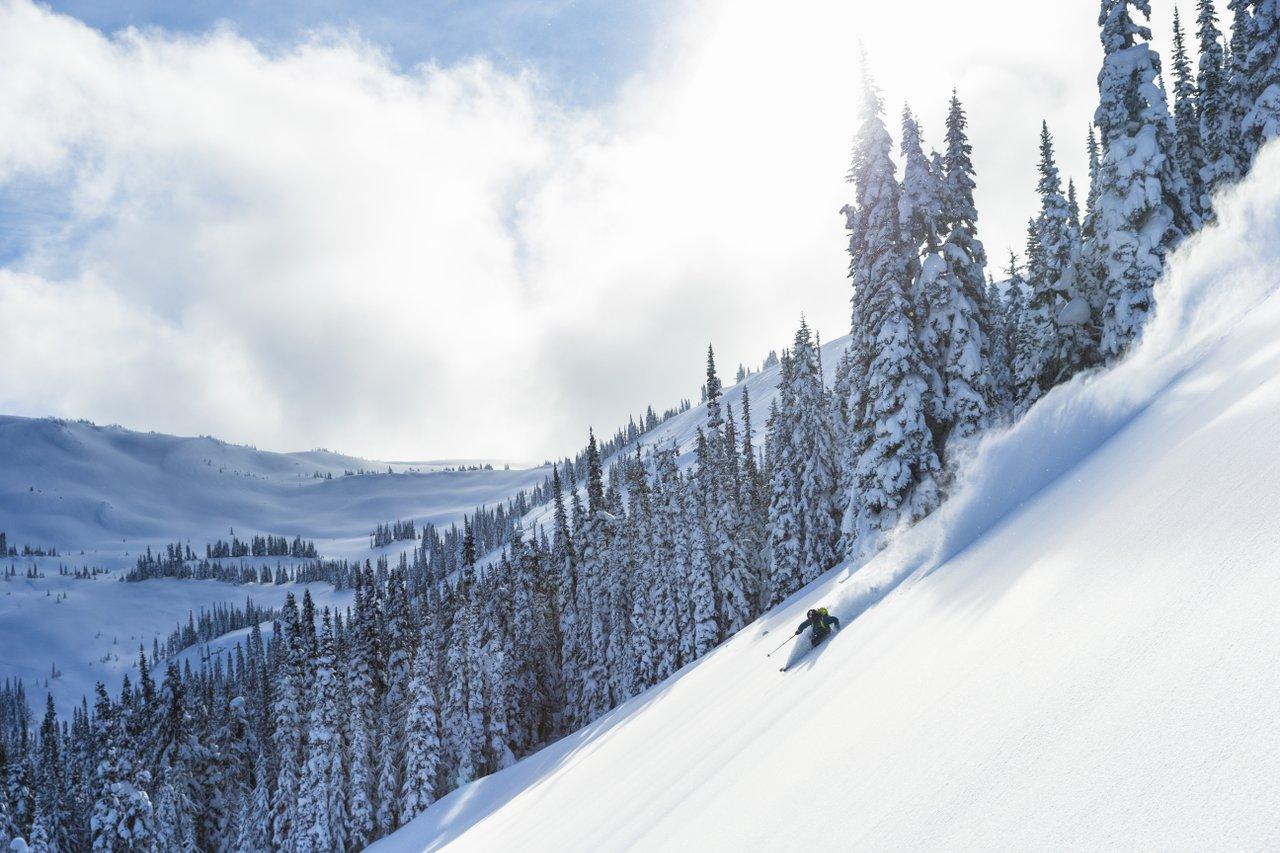
The mountains of BC: a ski and snowboard paradise

Where to see fall colors in Canada

Best camping in Canada – with a twist
Get Your Local Running Newsletter
Plan your week with local routes, events, and weather.
BEST WEEK EVER
Try out unlimited access with 7 days of Outside+ for free.
Start Your Free Trial

The Most Epic Road Trip in North America

Immerse yourself in awe-inspiring landscapes, geological wonders, and cultural experiences closely tied to the land in The Great Wilderness of northern British Columbia
Massive in scale and steeped in Indigenous cultures that go back millennia, the far north of British Columbia is unlike anywhere you’ve ever experienced. These vast otherworldly landscapes call to those who seek a deeper connection to nature. From geothermal hot springs and ancient lava beds to one of the largest glaciers in Canada, you could spend a lifetime adventuring in this remote region, known as The Great Wilderness , and there will always be more to see and learn.
Whether you have a few days or a couple weeks to explore, the Great Northern Circle Route is a great place to start. This 1,981-mile loop connects the Stewart-Cassiar (Hwy. 37), Yellowhead (Hwy. 16), and Alaska (Hwy. 97) highways on a journey packed with natural wonders and community immersion. Connect with the histories and living cultures of more than 50 distinct First Nations who have been caretakers of these spectacular landscapes from the start. Traverse rolling prairies, hike through boreal forests, and witness incredible biodiversity. Starting from Prince George—where direct flights from Vancouver and six other airports in British Columbia and Alberta easily connect travelers to all the grandeur The Great Wilderness has in store—here are just some of the once-in-a-lifetime experiences that await you in the far north of British Columbia.
Spot Awe-Inspiring Wildlife
In an area as vast as The Great Wilderness , wildlife encounters could happen in many places, but a few spots stand out for animal activity. Enormous even by The Great Wilderness standards, the 25,000-square-mile Muskwa-Kechika Management Area is a haven for subarctic species, including moose, elk, plains bison, grizzly bears, Stone’s sheep, and northern mountain caribou. This uniquely managed area, in the traditional territories of the Kaska Dena, Treaty 8, and Carrier-Sekani, aims to balance conservation and responsible land use based on centuries of Indigenous wisdom and teachings. Because the area has limited road access from the Alaska Highway, wildlife lovers will get the most out of a visit to Muskwa-Kechika’s ancient mountain ranges, alpine meadows, and river valleys with a multiday backcountry experience. Access Muskwa-Kechika by floatplane, then travel by foot, horseback, or canoe to explore routes that crisscross this remote wilderness. If it’s your first time in the backcountry of northern British Columbia, book a guided trip. Knowledgeable local outfitters can help you safely and respectfully spot a range of wildlife in the area.

Soak in a Natural Hot Spring
Those with ancestral roots in the Liard River area—people speaking the Athapaskan and Kaska languages, with original groups including the Beaver, Sikanni, Nahanni, and Dog Rib—have understood the therapeutic benefits of geothermal energy for thousands of years. Experience the calming effects of soaking in naturally heated mineral-infused water yourself at Liard River Hot Springs Provincial Park , the second-largest hot springs in Canada. Tucked into a spruce-filled boreal wetland, the hot springs complex consists of eight natural springs, including a rustic pool built for soaking in 108-degree water.
After your soak, wander along the boardwalks to explore this unique ecosystem. The area’s geothermal activity attracts more than just human visitors. Keep an eye out for unique flora and fauna, including massive moose, which frequent the area year-round to graze on aquatic vegetation, tiny chub that thrive in warm water, and 14 varieties of orchids.

Learn from the Gitxsan People
The Great Wilderness offers many opportunities to connect with communities who have stewarded this land for thousands of years. Foster your understanding and appreciation of the enduring legacy of the Gitxsan people at the ‘Ksan Historical Village and Museum . Located at the confluence of the Skeena and Bulkley rivers, the replica village gives visitors a chance to see Gitxsan traditions firsthand. Listen as practiced storytellers share oral histories of the Gitxsan culture, spiritual beliefs, artistry, and social structures. Take a peek inside traditional Gitxsan and Wet’suwet’en longhouses. Then see intricate totem poles up close and watch traditional totem carvers at work.

See How Glaciers Shaped the Landscape
The topography of The Great Wilderness is deeply connected to glacier activity over thousands of years. Get an up-close look at the massive scale of glacial ice at the Salmon Glacier , located 25 miles northwest of Stewart, British Columbia. As the fifth-largest glacier in Canada and the largest vehicle-accessible glacier in the world, the Salmon Glacier offers a chance to fully appreciate the grandeur of these ancient ice giants. Stop at the Stewart Visitor Center for details on road conditions before heading out on a 23-mile drive along the unpaved Granduc Road (Salmon Glacier Road), passing dense forests and historic mining camps along the route. Near mile 17, stop at the glacier’s toe, where you can hop out for a closer look and a photo. Then continue on to the upper viewpoint at about 4,000 feet.
Note: The road to access the Salmon Glacier from Stewart crosses into Alaska before returning to the high point of the glacier in British Columbia. You can find border-crossing information here .
Ready to trade your day-to-day for a journey into these extraordinary landscapes? On the Great Northern Circle route, you can feel the heartbeat of The Great Wilderness and learn from those who have shaped this diverse and magnetic area. Get more details on the adventures above and countless other ways to experience the captivating The Great Wilderness of northern British Columbia at HelloBC.com .
Journey into The Great Wilderness, the northernmost area of British Columbia, Canada, where adventures await curious wanderers. Immerse yourself in a place where Indigenous culture is deeply rooted in the vast lands, an extraordinary landscape of jagged mountains, glittering glaciers, booming waterways, and diverse wildlife. Learn more at HelloBC.com .
Continue Exploring British Columbia
Journey into The Great Wilderness
Ski the Best-Kept Secrets in British Columbia, Canada
- British Columbia
IMAGES
VIDEO
COMMENTS
An hour's drive along a gravel road, you'll find exceptional canoeing on the Nation Lakes Chain, a 5-to-10 day, 120-kilometre (75-mile) route on four wilderness lakes. Ancient Forest near Prince George | Jongsun Park. To complete the circle route, return to Prince George via Highway 16 east. Last updated: Feb. 28, 2024.
Northern British Columbia is a vast and rugged part of the province. Two main highways make their way through this landscape. Separating at Prince George, Highway 16 heads west to Prince Rupert, meeting Highway 37, which winds its way up the western interior while Highway 97 travels the eastern interior, visiting Dawson Creek, Fort St. John and Fort Nelson on route to meeting Highway 37 at ...
Explore the untamed wilderness and stunning mountain ranges of Northern British Columbia on a 1,800-kilometre road trip. Discover wildlife, heritage sites, and scenic attractions along the Yellowhead Highway 16, the Stewart-Cassiar Highway 37, and the Alaska Highway 97.
However, a few start in Victoria, which also has an international airport. You can also catch the ferry from Vancouver to Victoria, or even enjoy a seaplane flight and then rent a car once you arrive in Victoria. 1. Vancouver to Whistler Road Trip - Sea to Sky Highway (1 Day) Start: Vancouver. End: Whistler.
This giant loop of Northern British Columbia is the ultimate road trip. Follow the Alaska Highway north, through the Northern Rockies, and back south on the Stewart-Cassiar Highway before heading back along Highway 16. The natural scenery is staggering and the wildlife sightings are endless. Uncover the past at historic and cultural sites, pull ...
Northern BC begins at the city of Prince George and extends up to the Yukon/Alaska border. This vast region also encompasses the Haida Gwaii archipelago. Hiking, swimming, fly fishing, kayaking — all can be done in this natural playground and in one epic road trip. This spectacularly scenic route puts the natural beauty of Canada on full display.
The Great Northern Circle Route is an incredible 10-15 days camping road trip through the untamed wilderness of British Columbia's North. In this trip, you will enjoy the serenity of nature and experience the real wilderness of BC's North. Note: This post is for travellers that have limited time and cannot travel for a long time on an RV.This road trip can be completed easily in two weeks.
The Great Wilderness: Alaska Highway. Part 1: Start Your Trip. Part 2: Dawson Creek. Part 3: Taylor. Part 4: Fort St. John. Part 5: Fort Nelson. Part 6: Stone Mountain Provincial Park. Part 7: Muncho Lake Provincial Park. Part 8: Liard River Hot Springs Provincial Park & Smith River Falls.
14 Days. 11 Stops. 2609 KM. SHARE THIS. From the rolling prairies and wide-open skies of Peace River Country to the untamed sweeping strata of the Northern Rockies and through lush boreal forests and azure-hued lakes of the Stewart-Cassiar, the Great Northern Circle Route is a quintessential RV bucket-list adventure.
Northern British Columbia is a wild and rugged landscape, home to mighty glaciers, ancient forests, and untamed rivers. Grizzly bears roam the land here while the phenomena of the Aurora dances the night away. From Gold Rush Trail to Haida Gwaii, here's what to expect from a Northern BC road trip along Highway 16.
The easiest way to explore British Columbia's natural beauty, small towns, and wildlife is by open road. Cross the province west to east on a trip to the Canadian Rockies, or find adventure from south to north along Highway 97 and the Alaska Highway. There are scenic trips along the coast, roads that explore local food and drink scenes, and ...
By Road. Four main highways give access to Northern BC: Yellowhead Highway 16 from the Alberta border in the east to Prince Rupert west on the Pacific coast. At Kitwanga you can head north on Highway 37 to Stewart, Yukon and Alaska. Alaska Highway 97 north from Prince George to Dawson Creek and the Peace River Country.
Ultimate Northern BC Summer Road Trip Day Two: Smithers. The drive from Prince George to Smithers offers a picturesque journey through the stunning wild world of Northern BC. The drive takes approximately four and a half hours, depending on traffic and road conditions. Stock up on your favourite road snacks and drinks and prepare to soak it all ...
8-Day Itinerary: Northern BC Road Trip. This 8-day itinerary is based on the Northern BC trip experienced by one of our lucky contest winners. It features 8 stops that could be spread out over 2 weeks or more to really experience what the region has to offer. Access: Start in Williams Lake | End in Terrace. Total duration: 8 Days (or more)
Getting to Dawson Creek, BC. - Mile 0 of the Alaska Highway. From Grande Prairie, Alberta (Two Routes) West, Then North - take Highway 43 west and once you're into B.C., the road becomes Highway 2 - the Dawson Creek-Tupper Highway. This route passes Swan Lake Provincial Park and Pouce Coupe, then enters Dawson Creek, Mile 0 of the ...
From Prince George in the south, two main highways snake their way up the east and west sides of Northern BC. To the east, Highway 97 provides access to communities including Chetwynd, Hudson's Hope, Tumbler Ridge, Fort St. John, Pink Mountain, Fort Nelson and Muncho Lake. Highway 16 and 37 to the west visit Smithers, Terrace, Prince Rupert ...
Getty Images. If you plan to fly into Canada and rent an RV or car for your road trip, the most logical place to start is either in Calgary in the neighboring province of Alberta or in Vancouver. Seattle, a two-hour drive away from the Canada/U.S. border, would also be a convenient takeoff point for a drive around British Columbia.
Whether you have a few days or a couple weeks to explore, the Great Northern Circle Route is a great place to start. This 1,981-mile loop connects the Stewart-Cassiar (Hwy. 37), Yellowhead (Hwy. 16), and Alaska (Hwy. 97) highways on a journey packed with natural wonders and community immersion. Connect with the histories and living cultures of ...
Like you, we're passionate about exploring BC. From Mile Zero of the Trans Canada Highway on southern Vancouver Island to Mile Zero of the Alaska Highway in BC's northeast—and everywhere in between—the maps below will help you chart a course for your western Canada road trip. Looking to hit the slopes? Check out the BC Ski Map to access perfect powder at a resort or community ski hill.
TUMBLER RIDGE. From Chetwynd, detour south on Highway 29 to Tumbler Ridge. Possibly one of the most iconic locations in Northern BC, the Tumbler Ridge Unesco Global Geopark is truly a sight to behold.. From towering waterfalls to real-deal dinosaur tracks, its geology and sprawling crags, canyons and hills will have you swooning at this unique and ancient area.
Whether you want to hit the road for a few weeks with friends, or need to shove as much scenery as possible into a few days, here are seven routes that show off the best of BC. The Sea-to-Sky Highway - Credit: Destination BC. 1. The Sea-to-Sky Highway. That old saying that it isn't about the destination but the journey, that starts to make ...
Northern BC's vast wilderness makes this an RV trip of epic proportions. Bookended by two northern hubs—Prince George and Prince Rupert—and with a side trip into the beautiful and ancient Nass Valley, this route stretches more than 1,000 km (620 miles) through temperate rainforest, majestic peaks, famed rivers, and the site of Canada's last volcanic […]
Whether you have a few days or a couple weeks to explore, the Great Northern Circle Route is a great place to start. This 1,981-mile loop connects the Stewart-Cassiar (Hwy. 37), Yellowhead (Hwy ...