

leiden specialcollections blog

Guest author

The cartography of Captain James Cook
June 02, 2019 • Maps and Atlases • 4 min read
It must have been quite the sight. On the 3rd of June 1769 – now 250 years ago – Englishmen were on the island of Tahiti looking through high-quality telescopes to watch a rare natural phenomenon: the transit of Venus across the face of the Sun.
Leader of this group was Captain James Cook (1728-1779) who sailed the globe aboard the now legendary HMS Endeavour. The journey would lead to the exploration of large parts of Polynesia, a full circumnavigation of the main islands of New Zealand, and a better understanding of the eastern coastline of Australia. The voyage would fill in many blank spots in European cartography. Leiden University Libraries has some very fine maps of the travels of James Cook in their collections.
James Cook is now immortalized as one of the most distinguished European explorers of all time, closely connected with the (British) colonization of New-Zealand and Australia, and his grisly death at Kealakekua Bay, Hawaii. In 1768 he was still a relatively unknown officer in the service of the Royal Navy, who was tasked to sail the globe. Cook was given a dual task. For the Royal Society he was to facilitate a group of naturalists, headed by a young but very ambitious Joseph Banks (1743-1820), who would record the transit of Venus across the face of the Sun from the island of Tahiti. By carefully recording this natural phenomenon from several locations on the globe a scientific enigma could be solved: the exact distance between Earth and Sun. The naturalists would also collect and draw botanical, zoological and ethnographical specimen during the voyage. These pioneering experiences aboard the Endeavour provided a blueprint for every subsequent scientific voyage.
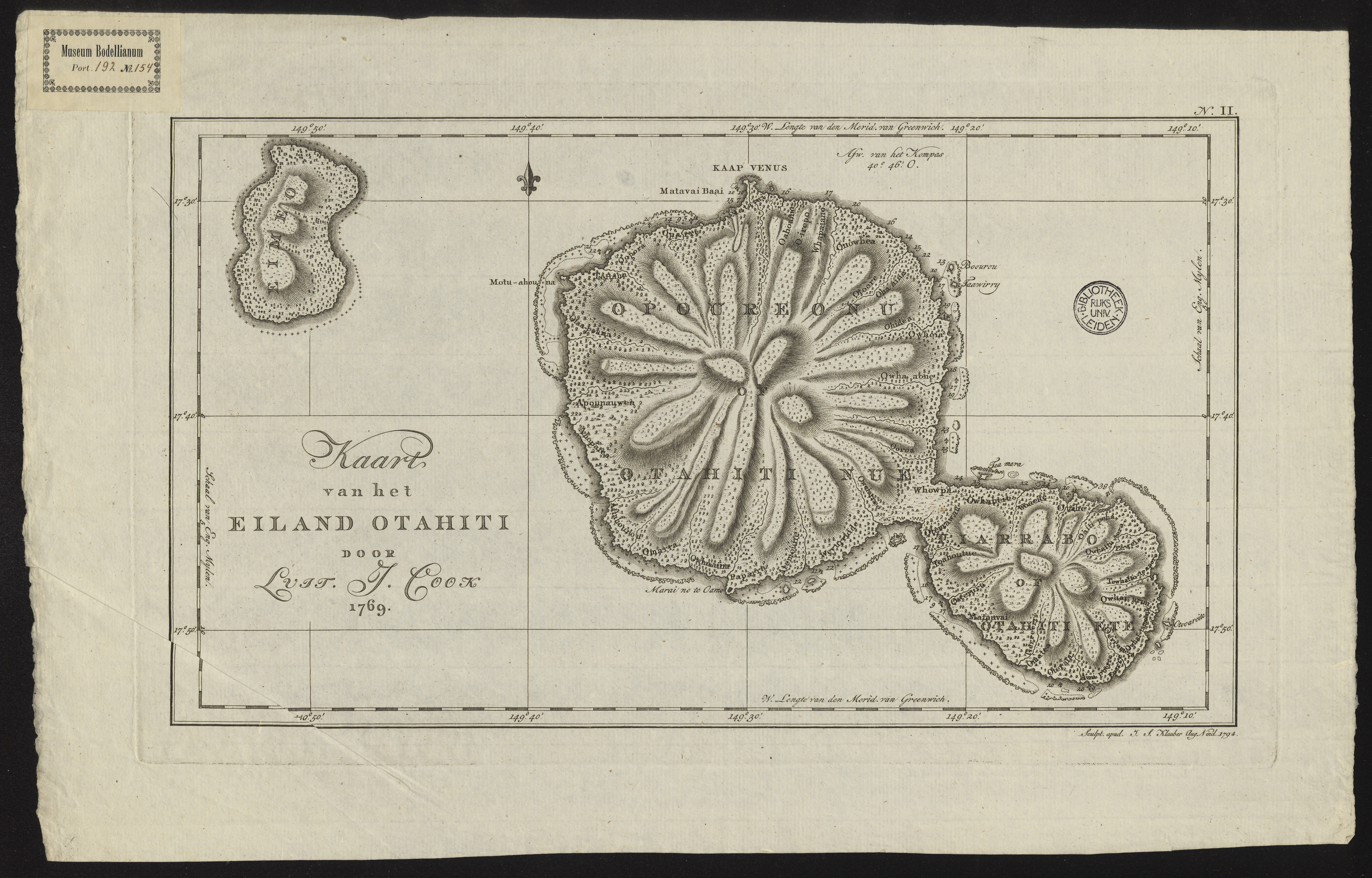
Figure 2: COLLBN Port 192 N 154: map of the island Tahiti. At the northern part, at Matavai Bay, a temporary observatory (Cape Venus) was constructed to record the transit of Venus.
Cook was also handed sealed instructions by the government, to be opened after the transit of Venus was recorded. He was instructed to seek out the “Great Southern Continent”, an undiscovered landmass believed to lie somewhere in the southern hemisphere. In the late eighteenth century there was much imperial rivalry between the European powers. England wanted to reach this fabled Terra Australis before the competition. During his travels aboard the Endeavour Cook sailed south to the 40th parallel, before heading to New Zealand. During his second circumnavigation (1772-1775) Cook crossed the Antarctic Circle thrice, proving once and for all that there was no great landmass on the southern hemisphere.
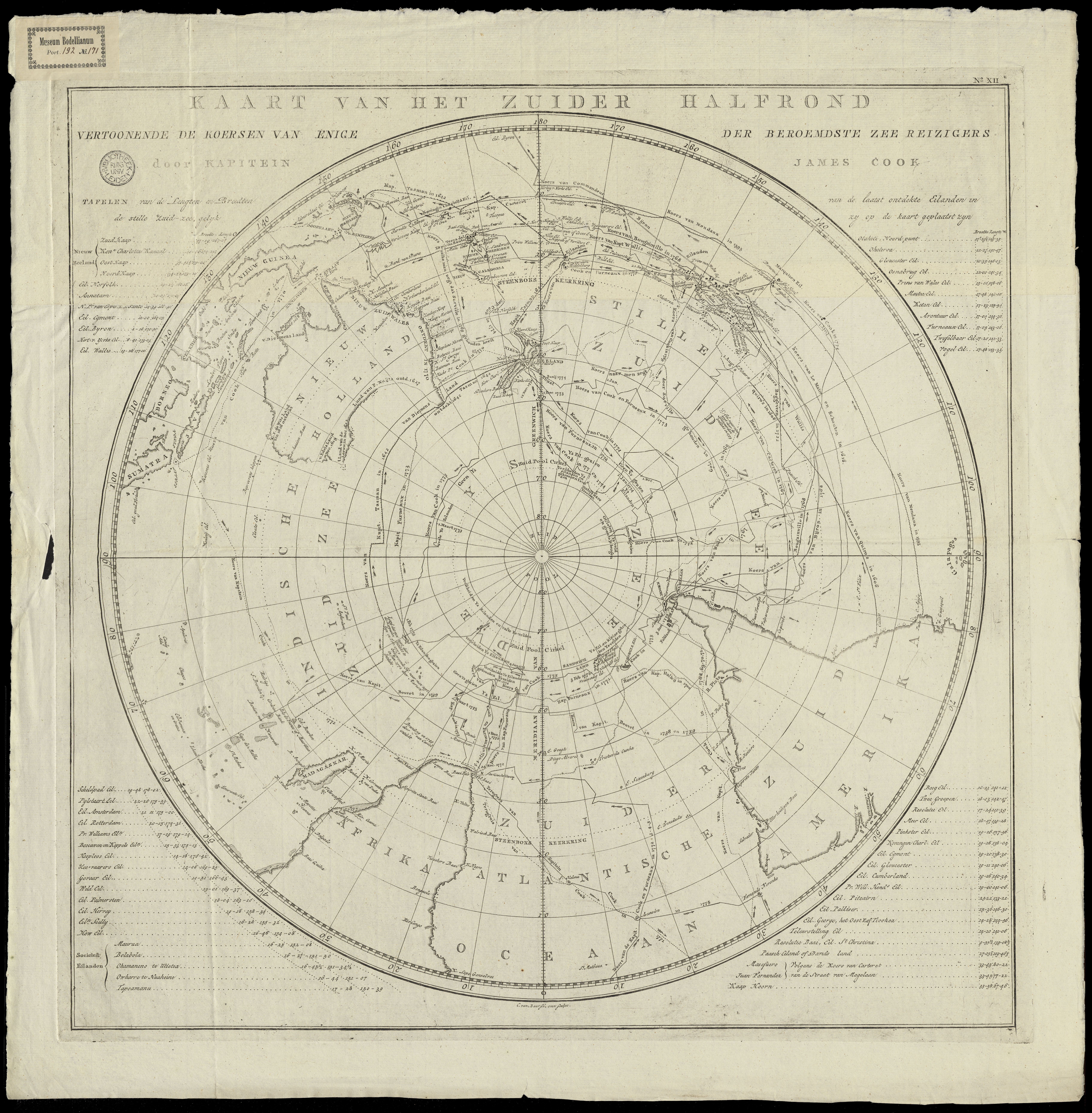
Figure 3: COLLBN Port 192 N 171: map of the southern hemisphere. The remarkable view, with the Antarctic at its center, allowed for the representation of the travels made by James Cook, and European explorers before him.
It is still fairly unknown that James Cook, besides being an excellent navigator and commander, was a very capable cartographer. Before his involvement with imperial exploration, Cook was stationed in Canada where he developed skills in surveying and drawing. When he reached New Zealand in October 1769 he used a technique known as a running survey, allowing him to survey the coastlines of the New Zealand islands while sailing. His data was so accurate that it remained unsurpassed for over a century. When Cook returned to Europe his collected cartographic data was almost immediately turned into print, satisfying an audience eager to learn more about the adventures of the South Seas Expedition.
The highlighted maps from the collections of Leiden University Libraries prove the immense popularity of Cook’s travels, even decades after his death. They come from the Dutch series Reize rondom de waereld , translated by Jan D. Pasteur (1753-1804) and jointly published in 13 volumes between 1795 and 1803 by the publishers Honkoop (Leiden), Allart (Amsterdam) and Van Cleef (The Hague). Pasteur was an influential politician during the Batavian Republic (1795-1806), successor state of the Republic of the Seven United Netherlands, and worked on this immense translation project in his spare time. About the accompanying plates, and maps, Pasteur wrote: “the quality of the execution, we are not afraid to say, surpasses that of the original English edition.”
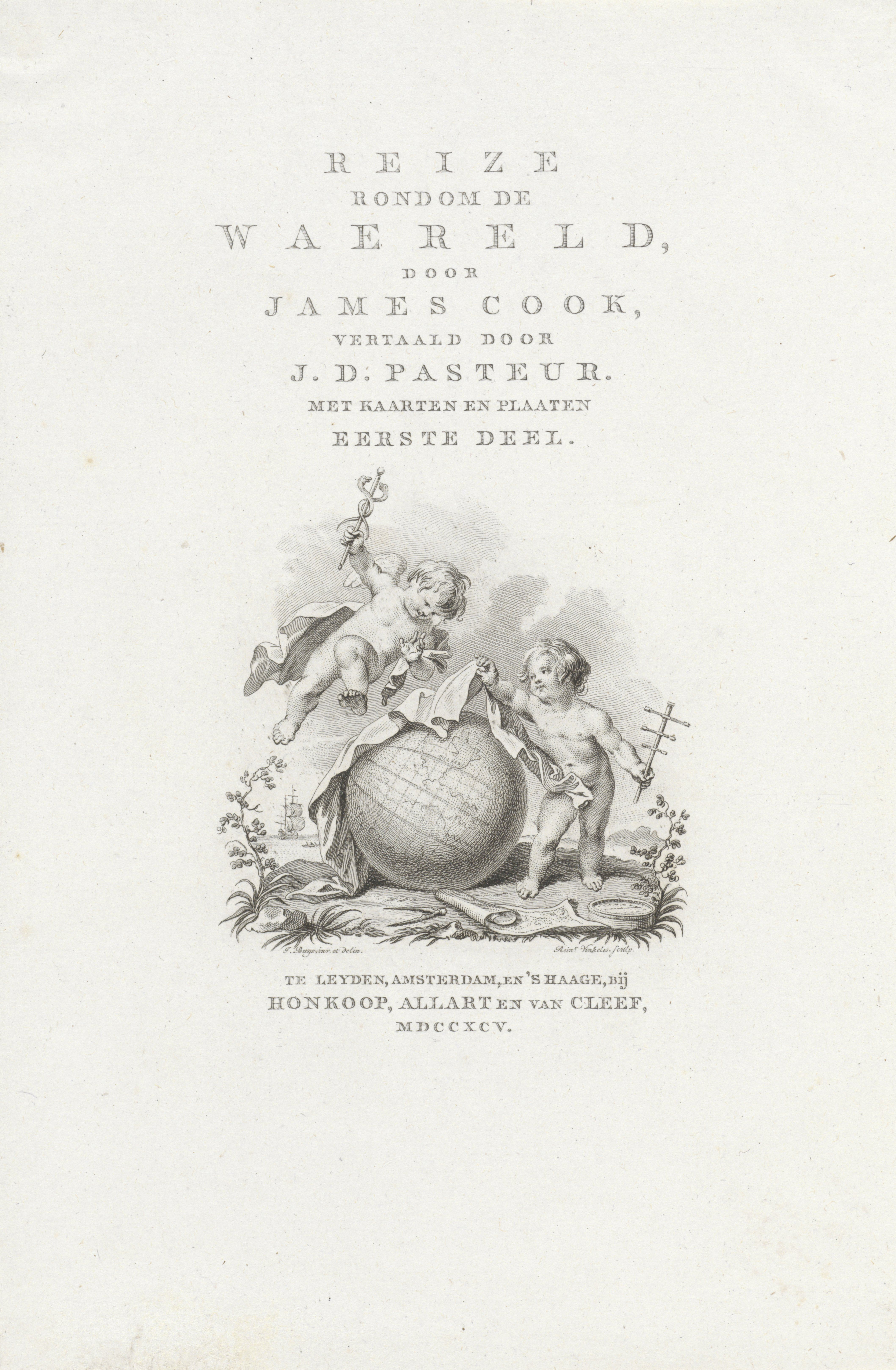
Figure 4: Title page for Reize rondom de waereld by James Cook, translated into Dutch by Jan D. Pasteur, 1795.
The greatest compliment about the enduring relevance of the cartography of Captain James Cook comes from the now 93-years old naturalist and BBC broadcaster Sir David Attenborough. When asked in 2018 about its accuracy, Attenborough remarked: “Well oddly enough I've actually sailed in the northern part of the Great Barrier Reef (Australia) using a chart that was prepared by Captain James Cook. It was still in use in the 1950s. His navigation was extraordinarily accurate. He continued to make all these detailed plottings, while he encountered great difficulties.”
Highlighted works:
COLLBN Port 192 N 67: Kaart van Nieuw Zuid Wales of de Oostlyke Kust van Nieuw Holland
COLLBN Port 192 N 154: Kaart van het Eiland Otahiti
COLLBN Port 192 N 171: Kaart van het zuider halfrond : vertoonende de Koersen van enige der beroemdste zee reizigers
KITLV3 M 3c 52: Reize rondom de waereld
Blog post by: Jeroen Bos, library staff member Leiden University Libraries, Early Modern History lecturer at Groningen University and co-author of Comprehensive Atlas of the Dutch United East India Company (Volume VI).
James Cook and his voyages
The son of a farm labourer, James Cook (1728–1779) was born at Marton in Yorkshire. In 1747 he was apprenticed to James Walker, a shipowner and master mariner of Whitby, and for several years sailed in colliers in the North Sea, English Channel, Irish Sea and Baltic Sea. In 1755 he volunteered for service in the Royal Navy and was appointed an able seaman on HMS Eagle . Within two years he was promoted to the rank of master and in 1758 he sailed to North America on HMS Pembroke . His surveys of the St Lawrence River, in the weeks before the capture of Quebec, established his reputation as an outstanding surveyor. In 1763 the Admiralty gave him the task of surveying the coast of Newfoundland and southern Labrador. He spent four years on HMS Grenville , recording harbours and headlands, shoals and rocks, and also observed an eclipse of the sun in 1766.
First voyage
In May 1768 Cook was promoted to the rank of lieutenant and given command of the bark Endeavour . He was instructed to sail to Tahiti to observe the transit of Venus in 1769 and also to ascertain whether a continent existed in the southern latitudes of the Pacific Ocean. The expedition, which included a party of scientists and artists led by Joseph Banks, left Plymouth in August 1768 and sailed to Brazil and around Cape Horn, reaching Tahiti in April 1769. After the astronomical observations were completed, Cook sailed south to 40°S, but failed to find any land. He then headed for New Zealand, which he circumnavigated, establishing that there were two principal islands. From New Zealand he sailed to New Holland, which he first sighted in April 1770. He charted the eastern coast, naming prominent landmarks and collecting many botanical specimens at Botany Bay. The expedition nearly ended in disaster when the Endeavour struck the Great Barrier Reef, but it was eventually dislodged and was careened and repaired at Endeavour River. From there it sailed around Cape York through Torres Strait to Batavia, in the Dutch East Indies. In Batavia and on the last leg of the voyage one-third of the crew died of malaria and dysentery. Cook and the other survivors finally reached England in July 1771.
Second voyage
In 1772 Cook, who had been promoted to the rank of captain, led a new expedition to settle once and for all the speculative existence of the Great Southern Continent by ‘prosecuting your discoveries as near to the South Pole as possible’. The sloops Resolution and Adventure , the latter commanded by Tobias Furneaux, left Sheerness in June 1772 and sailed to Cape Town. The ships became separated in the southern Indian Ocean and the Adventure sailed along the southern and eastern coasts of Van Diemen’s Land before reuniting with the Resolution at Queen Charlotte Sound in New Zealand. The ships explored the Society and Friendly Islands before they again became separated in October 1773. The Adventure sailed to New Zealand, where 10 of the crew were killed by Maori, and returned to England in June 1774. The Resolution sailed south from New Zealand, crossing the Antarctic Circle and reaching 71°10’S, further south than any ship had been before. It then traversed the southern Pacific Ocean, visiting Easter Island, Tahiti, the Friendly Islands, New Hebrides, New Caledonia, Norfolk Island and New Zealand. In November 1774 Cook began the homeward voyage, sailing to Chile, Patagonia, Tierra del Fuego, South Georgia and Cape Town. The expedition reached England in July 1775.
Third voyage
A year later Cook left Plymouth on an expedition to search for the North West Passage. His two ships were HMS Resolution and Discovery , the latter commanded by Charles Clerke. They sailed to Cape Town, Kerguelen Island in the southern Indian Ocean, Adventure Bay in Van Diemen’s Land, and Queen Charlotte Sound in New Zealand. They then revisited the Friendly and Society Islands. Sailing northwards, Cook became the first European to travel to the Hawaiian Islands (which he named the Sandwich Islands), and reached the North American coast in March 1778. The ships followed the coast northwards to Alaska and the Bering Strait and reached 70°44’N, before being driven back by ice. They returned to the Sandwich Islands and on 14 February 1779 Cook was killed by Hawaiians at Kealakekua Bay. Clerke took over the command and in the summer of 1779 the expedition again tried unsuccessfully to penetrate the pack ice beyond Bering Strait. Clerke died in August 1779 and John Gore and James King commanded the ships on the voyage home via Macao and Cape Town. They reached London in October 1780.
Acquisition
The earliest acquisitions by the Library of original works concerning Cook’s voyages were the papers of Sir Joseph Banks and a painting of John Webber, which were acquired from E.A. Petherick in 1909. In 1923 the Australian Government purchased at a Sotheby’s sale in London the Endeavour journal of James Cook, together with four other Cook documents that had been in the possession of the Bolckow family in Yorkshire. The manuscripts of Alexander Home were purchased from the Museum Bookstore in London in 1925, while the journal of James Burney was received with the Ferguson Collection in 1970. A facsimile copy of the journal of the Resolution in 1772–75 was presented by Queen Elizabeth II in 1954.
The 18 crayon drawings of South Sea Islanders by William Hodges were presented to the Library by the British Admiralty in 1939. They had previously been in the possession of Greenwich Hospital. The view from Point Venus by Hodges was bought at a Christie’s sale in 1979. The paintings of William Ellis were part of the Nan Kivell Collection, with the exception of the view of Adventure Bay, which was bought from Hordern House in Sydney in 1993. The painting of the death of Cook by George Carter and most of the paintings of John Webber were also acquired from Rex Nan Kivell. The painting by John Mortimer was bequeathed to the Library by Dame Merlyn Myer and was received in 1987.
Description
Manuscripts.
The Endeavour journal of James Cook (MS 1) is the most famous item in the Library’s collections. It has been the centrepiece of many exhibitions ever since its acquisition in 1923, and in 2001 it became the first Australian item to be included on the United Nations Educational, Scientific and Cultural Organization’s (UNESCO’s) Memory of the World Register. While there are other journals of the first voyage that are partly in Cook’s hand, MS 1 is the only journal that is entirely written by Cook and covers the whole voyage of the Endeavour . The early entries in 1768, as the ship crossed the Atlantic Ocean, are brief but the passages describing Cook’s experiences and impressions in Tahiti, New Zealand and New South Wales in 1769–70 are very detailed. The journal, which is 753 pages in length, was originally a series of paper volumes and loose sheets, but they were bound into a single volume in the late nineteenth century. The current binding of oak and pigskin dates from 1976.
Two other manuscripts, also acquired in 1923, relate to the first voyage. The Endeavour letterbook (MS 2), in the hand of Cook’s clerk, Richard Orton, contains copies of Cook’s correspondence with the Admiralty and the various branches of the Navy Board. Of particular importance are the original and additional secret instructions that he received from the Lords of the Admiralty in July 1768. The other item (MS 3) is a log of the voyage, ending with the arrival in Batavia. The writer is not known, although it may have been Charles Green, the astronomer. Other documents concerning the voyage are among the papers of Joseph Banks (MS 9), including his letters to the Viceroy of Brazil in 1768 and the ‘Hints’ of the Earl of Morton, the president of the Royal Society.
The Library holds a facsimile copy (MS 1153) of the journal of HMS Resolution on the second voyage, the original of which is in the National Maritime Museum in London. It is in the hand of Cook’s clerk, William Dawson. It also holds the journal (MS 3244) of James Burney, a midshipman on HMS Adventure , covering the first part of the voyage in 1772–73. It includes a map of eastern Van Diemen’s Land and Burney’s transcription of Tongan music. In addition, there is a letterbook (MS 6) of the Resolution for both the second and third voyages. Documents of the third voyage include an account of the death of Cook (MS 8), probably dictated by Burney, and two manuscripts of Alexander Home (MS 690). They contain descriptions of Tahiti and Kamtschatka and another account of Cook’s death.
The earliest manuscript of Cook in the collection is his description of the coast of Nova Scotia, with two maps of Harbour Grace and Carbonere, dating from 1762 (MS 5). The Library holds original letters of Cook written to John Harrison, George Perry, Sir Philip Stephens and the Commissioners of Victualling. There is also in the Nan Kivell Collection a group of papers and letters of the Cook family, 1776–1926 (MS 4263).
MS 1 Journal of the H.M.S. Endeavour, 1768-1771
MS 2 Cook's voyage 1768-71 : copies of correspondence, etc. 1768-1771
MS 3 Log of H.M.S. Endeavour, 1768-1770
MS 5 Description of the sea coast of Nova Scotia, 1762
MS 6 Letterbook, 1771-1778
MS 8 Account of the death of James Cook, 1779
MS 9 Papers of Sir Joseph Banks, 1745-1923
MS 690 Home, Alexander, Journals, 1777-1779
MS 1153 Journal of H.M.S. Resolution, 1772-1775
MS 3244 Burney, James, Journal, 1772-1773
MS 4263 Family papers 1776-1926
Many records relating to the voyages of Cook have been microfilmed at the National Archives (formerly the Public Record Office) in London and other archives and libraries in Britain. They include the official log of HMS Endeavour and the private journals kept by Cook on his second and third voyages. The reels with the prefixes PRO or M were filmed by the Australian Joint Copying Project.
mfm PRO 3268 Letters of Capt. James Cook to the Admiralty, 1768–79 (Adm. 1/1609-12)
mfm PRO 1550–51 Captain’s log books, HMS Adventure , 1772–74 (Adm. 51/4521-24)
mfm PRO 1554 Captain’s log books, HMS Discovery , 1776–79 (Adm. 51/ 4528-9)
mfm PRO 1554 Captain’s log books, HMS Resolution , 1779 (Adm. 51/4529)
mfm PRO 1555–6 Captain’s log books, HMS Discovery , 1776–79 (Adm. 51/4530-1)
mfm PRO 1561–3 Captain’s log books, HMS Endeavour , 1768–71 (Adm. 51/4545-8)
mfm PRO 1565–70 Captain’s log books, HMS Resolution , 1771–79 (Adm. 51/4553-61)
mfm PRO 1572 Logbooks, HMS Adventure , 1772–74 (Adm. 53/1)
mfm PRO 1575–6 Logbooks, HMS Discovery , 1776–79 (Adm. 53/20-24)
mfm PRO 1580 Logbooks, HMS Endeavour , 1768–71 (Adm. 53/39-41)
mfm PRO 1590–4 Logbooks, HMS Resolution , 1771–80 (Adm. 53/103-24)
mfm PRO 1756 Logbook, HMS Adventure , 1772–74 (BL 44)
mfm PRO 1756 Observations made on board HMS Adventure , 1772–74 (BL 45)
mfm PRO 1756A Logbook, HMS Resolution , 1772–75 (BL 46)
mfm PRO 1756 Observations made on board HMS Resolution , 1772–75 (BL 47)
mfm PRO 1756 Journal of Capt. J. Cook: observations on variations in compass and chronometer rates, 1776 (BL 48)
mfm PRO 1756 Astronomical observations, HMS Resolution , 1778–80 (BL 49)
mfm PRO 4461–2 Ship’s musters, HMS Endeavour , 1768–71 (Adm. 12/8569)
mfm PRO 4462–3 Ship’s musters, HMS Adventure , 1769–74 (Adm. 12/7550)
mfm PRO 4463–4 Ship’s musters, HMS Resolution , 1771–75 (Adm. 12/7672)
mfm PRO 4464 Ship’s musters, HMS Discovery , 1776–80 (Adm. 12/8013)
mfm PRO 4464–5 Ship’s musters, HMS Resolution , 1776–80 (Adm. 12/9048-9)
mfm PRO 6119 Deptford Yard letterbooks, 1765-78 (Adm. 106/3315-8)
MAP mfm M 406 Charts and tracings of Australian and New Zealand coastlines by R. Pickersgill and Capt. James Cook, 1769–70 (Hydrographic Department)
mfm M 869 Letters of David Samwell, 1773–82 (Liverpool City Libraries)
mfm M 1561 Log of HMS Endeavour , 1768–71 (British Library)
mfm M 1562 Journal of Capt. Tobias Furneaux on HMS Adventure , 1772–74 (British Library)
mfm M1563 Drawings of William Hodges on voyage of HMS Resolution , 1772–74 (British Library)
mfm M 1564 Log of Lieut. Charles Clerke on HMS Resolution , 1772–75 (British Library)
mfm M 1565 Journal of Lieut. James Burney on HMS Discovery , 1776–79 (British Library)
mfm M 1566 Journal of Thomas Edgar on HMS Discovery , 1776–79
mfm M 1580 Journal of Capt. James Cook on HMS Resolution , 1771–74 (British Library)
mfm M 1580–1 Journal of Capt. James Cook on HMS Resolution , 1776–79 (British Library)
mfm M 1583 Journal of David Samwell on HMS Resolution and Discovery , 1776–79 (British Library)
mfm M 2662 Correspondence of Sir Joseph Banks, 1768–1819 (Natural History Museum)
mfm M 3038 Letters of Capt. James Cook, 1775–77 (National Maritime Museum)
mfm M 3074 Drafts of Capt. James Cook’s account of his second voyage (National Maritime Museum)
mfm G 9 Journal of voyage of HMS Endeavour , 1768–71 (National Maritime Museum)
mfm G 13 Journal of voyage of HMS Resolution , 1772–75 (National Maritime Museum)
mfm G 27412 Journal of Capt. James Cook on HMS Endeavour , 1768–70 (Mitchell Library)
The only manuscript maps drawn by Cook held in the Library are the two maps of Halifax Harbour, Nova Scotia, contained in MS 5. The map by James Burney of Van Diemen’s Land, contained in his 1773–74 journal, is the only manuscript map in the Library emanating from Cook’s three Pacific voyages.
On the first voyage most of the surveys were carried out by Cook himself, assisted by Robert Molyneux, the master, and Richard Pickersgill, the master’s mate. Cook produced some of the fair charts, but it seems that most were drawn by Isaac Smith, one of the midshipmen. After the voyage the larger charts were engraved by William Whitchurch and a number of engravers worked on the smaller maps. The Library holds nine maps (six sheets) and five coastal views (one sheet) published in 1773, as well as two French maps of New Zealand and New South Wales based on Cook’s discoveries (1774).
Cook and Pickersgill, who had been promoted to lieutenant, carried out most of the surveys on the second voyage. Others were performed by Joseph Gilbert, master of the Resolution , Peter Fannin, master of the Adventure , the astronomer William Wales and James Burney. Isaac Smith, the master’s mate, again drew most of the fair charts of the voyage and William Whitchurch again did most of the engravings. The Library holds 15 maps (10 sheets) published in 1777.
On the third voyage, Cook seems to have produced very few charts. Most of the surveys were carried out by William Bligh, master of the Resolution , and Thomas Edgar, master of the Discovery . Henry Roberts, the master’s mate and a competent artist, made the fair charts and after the voyage he drew the compilation charts from which the engraved plates were produced. Alexander Dalrymple supervised the engravings. The Library holds five maps and five coastal views published in 1784–86.

The Library holds a number of objects that allegedly belonged to Cook, such as a walking stick, a clothes brush and a fork. A more substantial artefact is a mahogany and rosewood fall-front desk that was believed to have been used by Cook on one of his voyages. Other association items are a compass, protractor, ruler and spirit level owned by Alexander Hood, the master’s mate on HMS Resolution in 1772–75.
Three of the medals issued by the Royal Society in 1784 to commemorate the achievements of Cook are held in the Library. Another medal issued in 1823 to commemorate his voyages is also held.
The Library has several collections of tapa cloth, including a piece of cloth and two reed maps brought back by Alexander Hood in 1774 and a catalogue of 56 specimens of cloth collected on Cook’s three voyages (1787).
Captain James Cook's walking stick
Clothes brush said to have been the property of Captain Cook
Captain James Cook's fork
Mahogany fall-front bureau believed to have been used by Captain Cook
Compass, protractor, ruler and spirit level owned by Alexander Hood
Commemorative medal to celebrate the voyages of Captain James Cook (1784)
Medal to commemorate the voyages of Captain Cook (1823)
Sample of tapa cloth and two reed mats brought back by Alex Hood
A catalogue of the different specimens of cloth collected in the three voyages of Captain Cook
The Library holds a very large number of engraved portraits of James Cook, many of them based on the paintings by Nathaniel Dance, William Hodges and John Webber. It also holds two oil portraits by unknown artists, one being a copy of the portrait by Dance held in the National Maritime Museum in London. Of special interest is a large oil painting by John Mortimer, possibly painted in 1771, depicting Daniel Solander, Joseph Banks, James Cook, John Hawkesworth and Lord Sandwich.
There were two artists on the Endeavour : Alexander Buchan, who died in Tahiti in 1769, and Sydney Parkinson, who died in Batavia in 1771. The Library has a few original works that have been attributed to Parkinson, in particular a watercolour of breadfruit, which is in the Nan Kivell Collection. In addition, there are a number of prints that were reproduced in the publications of Hawkesworth and Parkinson in 1773, including the interior of a Tahitian house, the fort at Point Venus, a view of Matavai Bay, Maori warriors and war canoes, mountainous country on the west coast of New Zealand, and a view of Endeavour River.
William Hodges was the artist on the Resolution in 1772–75. The Library holds an outstanding collection of 18 chalk drawings by Hodges of the heads of Pacific Islanders. They depict men and women of New Zealand, Tahiti, Tonga, New Caledonia, New Hebrides and Easter Island. Other works by Hodges include an oil painting of a dodo and a red parakeet, watercolours of Tahiti, Tonga and the New Hebrides, and an oil painting of Point Venus. There are also two pen and wash drawings of the Resolution by John Elliott, who was a midshipman on the ship. Among the prints of Hodges are other heads of Pacific Islanders, a portrait of Omai, the Tahitian who visited England in 1775–76, and views of Tahiti, New Caledonia, New Hebrides, Norfolk Island, Easter Island and Tierra del Fuego.
John Webber, who was on the Resolution in 1776–80, had been trained as a landscape artist in Berne and Paris. Another artist on the expedition was William Ellis, the surgeon’s mate on the Discovery , who was a fine draughtsman. The Library holds 19 of Webber’s watercolours, ink and wash drawings, crayon drawings and pencil drawings of views in Tahiti, the Friendly Islands, the Sandwich Islands, Alaska and Kamchatka. There are also oil portraits by Webber of John Gore and James King. Ellis is equally well represented, with 23 watercolours, ink drawings and pencil drawings of scenes in Kerguelen Island, New Zealand, Tahiti, Nootka Sound, Alaska and Kamchatka. Of particular interest is a watercolour and ink drawing by Ellis of the Resolution and Discovery moored in Adventure Bay in 1777, the earliest original Australian work in the Pictures Collection. The death of Cook is the subject of the largest oil painting in the Library’s collection, painted by George Carter in 1781.
Omai, the first Polynesian to be seen in London, was the subject of a number of portraits, included a celebrated painting by Sir Joshua Reynolds. The Library has a pencil drawing of Omai by Reynolds. A pantomime by John O’Keefe entitled Omai, or a Trip Round the World , enjoyed great success in London in 1785–86, being played more than 50 times. The Library holds a collection of 17 watercolour costume designs for the pantomime, drawn by Philippe de Loutherbourg and based mainly on drawings by Webber. The subjects include ‘Obereyaee enchatress’, ‘Otoo King of Otaheite’, ‘a chief of Tchutzki’ and ‘a Kamtchadale’.
Publications
Bibliography.
Beddie,M.K. (ed.), Bibliography of Captain James Cook, R,N., F.R.S., circumnavigator , Library of New South Wales, Sydney, 1970.
Original Accounts of the Voyages
Hawkesworth, John, An account of the voyages undertaken by the order of His Present Majesty, for making discoveries in the Southern Hemisphere, and successively performed by Commodore Byron, Captain Wallis, Captain Carteret, and Captain Cook, in the Dolphin, the Swallow, and the Endeavour (3 vols, 1773)
Parkinson, Sydney, A journal of the voyage to the South Seas, in His Majesty’s Ship, the Endeavour (1773)
Marra, John, Journal of the Resolution’s Voyage, in 1772, 1773, 1774, and 1775, on Discovery to the Southern Hemisphere (1775)
Cook, James, A voyage towards the South Pole, and round the world: performed in His Majesty’s Ships the Resolution and the Adventure in the years 1772,1773, 1774, and 1775 (2 vols, 1777)
Forster, Georg, A voyage round the world in His Britannic Majesty’s Sloop, Resolution, Commanded by Capt. James Cook, during the years 1772, 3, 4 and 5 (2 vols, 1777)
Wales, William, The original astronomical observations, made in the course of a voyage towards the South Pole, and round the world (1777)
Rickman, John, Journal of Captain Cook’s last voyage to the Pacific Ocean, on discovery: performed in the years 1776, 1777, 1778, and 1779 (1781)
Zimmermann, Heinrich, Heinrich Zimmermanns von Wissloch in der Pfalz, Reise um die Welt, mit Capitain Cook (1781)
Ellis, William, An authentic narrative of a voyage performed by Captain Cook and Captain Clerke, in His Majesty’s ships Resolution and Discovery during the years 1776, 1777, 1778, 1779, and 1780 (2 vols, 1782)
Ledyard, John, Journal of Captain Cook’s last voyage to the Pacific Ocean, and in quest of a North-West Passage Between Asia & America, performed in the years 1776, 1777, 1778 and 1779 (1783)
Cook, James and King, James, A voyage to the Pacific Ocean: undertaken by Command of His Majesty, for making discoveries in the Northern Hemisphere, performed under the direction of Captains Cook, Clerke, and Gore, in the years 1776, 1777, 1778, 1779, and 1780 (4 vols, 1784)
Sparrman, Anders, Reise nach dem Vorgebirge der guten Hoffnung, den sudlischen Polarlandern und um die Welt (1784)
Modern Texts
Beaglehole, J.C. (ed.), The Endeavour journal of Joseph Banks, 1768–1771 (2 vols, 1962)
Beaglehole, J.C. (ed.), The journals of Captain James Cook on his voyages of discovery (4 vols, 1955–74)
David, Andrew (ed.), The charts & coastal Views of Captain Cook’s voyages (3 vols, 1988–97)
Hooper, Beverley (ed.), With Captain James Cook in the Antarctic and Pacific: the private journal of James Burney, Second Lieutenant on the Adventure on Cook’s second voyage, 1772–1773 (1975)
Joppien, Rudiger and Smith, Bernard, The art of Captain Cook’s voyages (3 vols in 4, 1985–87)
Parkin, Ray, H.M. Bark Endeavour: her place in Australian history: with an account of her construction, crew and equipment and a narrative of her voyage on the East Coast of New Holland in 1770 (1997)
Biographical Works and Related Studies
There are a huge number of books and pamphlets on the lives of Cook, Banks and their associates. The following are some of the more substantial works:
Alexander, Michael, Omai, noble savage (1977)
Beaglehole, J.C., The life of Captain James Cook (1974)
Besant, Walter, Captain Cook (1890)
Blainey, Geoffrey, Sea of dangers: Captain Cook and his rivals (2008)
Cameron, Hector, Sir Joseph Banks, K.B., P.R.S.: the autocrat of the philosophers (1952)
Carr, D.J., Sydney Parkinson, artist of Cook’s Endeavour voyage (1983)
Carter, Harold B., Sir Joseph Banks, 1743–1820 (1988)
Collingridge, Vanessa, Captain Cook: obsession and betrayal in the New World (2002)
Connaughton, Richard, Omai, the Prince who never was (2005)
Dugard, Martin, Farther than any man: the rise and fall of Captain James Cook (2001)
Duyker, Edward, Nature’s argonaut: Daniel Solander 1733–1782: naturalist and voyager with Cook and Banks (1998)
Furneaux, Rupert, Tobias Furneaux, circumnavigator (1960)
Gascoigne, John, Captain Cook: voyager between worlds (2007)
Hoare, Michael E., The tactless philosopher: Johann Reinhold Forster (1729–98) (1976)
Hough, Richard, Captain James Cook: a biography (1994)
Kippis, Andrew, The life of Captain James Cook (1788)
Kitson, Arthur, Captain James Cook, RN, FRS, the circumnavigator (1907)
Lyte, Charles, Sir Joseph Banks: 18th Century explorer, botanist and entrepreneur (1980)
McAleer, John and Rigby, Nigel, Captain Cook and the Pacific: art, exploration & empire (2017)
McCormick, E.H., Omai: Pacific envoy (1977)
McLynn, Frank, Captain Cook: master of the seas (2011)
Molony, John N., Captain James Cook: claiming the Great South Land (2016)
Moore, Peter, Endeavour: the ship and the attitude that changed the world (2018)
Mundle, Rob, Cook (2013)
Nugent, Maria, Captain Cook was here (2009)
Obeyesekere, Gananath, The apotheosis of Captain Cook: European mythmaking in the Pacific (1992)
O’Brian, Patrick, Joseph Banks, a life (1987)
Rienits, Rex and Rienits, Thea, The voyages of Captain Cook , 1968)
Robson, John, Captain Cook's war and peace: the Royal Navy years 1755-1768 (2009)
Sahlins, Marshall, How ‘natives’ think: about Captain Cook, for example (1995)
Saine, Thomas P., Georg Forster (1972)
Smith, Edward, The life of Sir Joseph Banks, president of the Royal Society (1911)
Thomas, Nicholas, Cook: The extraordinary voyages of Captain James Cook (2003)
Villiers, Alan, Captain Cook, the seamen’s seaman: a study of the great discoverer (1967).
Organisation
The manuscripts of Cook and his associates are held in the Manuscripts Collection at various locations. They have been catalogued individually. Some of them have been microfilmed, such as the Endeavour journal (mfm G27412), the Endeavour log and letterbook (mfm G3921) and the Resolution letterbook (mfm G3758). The Endeavour journal and letterbook and the papers of Sir Joseph Banks have been digitised and are accessible on the Library’s website. The microfilms have also been catalogued individually and are accessible in the Newspaper and Microcopy Reading Room.
The paintings, drawings, prints and objects are held in the Pictures Collection, while the maps and published coastal views are held in the Maps Collection. They have been catalogued individually and many of them have been digitised.
Biskup, Peter, Captain Cook’s Endeavour Journal and Australian Libraries: A Study in Institutional One-upmanship , Australian Academic and Research Libraries , vol. 18 (3), September 1987, pp. 137–49.
Cook & Omai: The Cult of the South Seas , National Library of Australia, Canberra, 2001.
Dening, Greg, MS 1 Cook, J. Holograph Journal , in Cochrane, Peter (ed.), Remarkable Occurrences: The National Library of Australia’s First 100 Years 1901–2001 , National Library of Australia, Canberra, 2001.
Healy, Annette, The Endeavour Journal 1768–71 , National Library of Australia, Canberra, 1997.
Healy, Annette, ' Charting the voyager of the Endeavour journal ', National Library of Australia News, volume 7(3), December 1996, pp 9-12
Hetherington, Michelle, 'John Hamilton Mortimer and the discovery of Captain Cook', British Art Journal, volume 4 (1), 2003, pp. 69-77
First posted 2008 (revised 2019)
The National Library of Australia acknowledges Australia’s First Nations Peoples – the First Australians – as the Traditional Owners and Custodians of this land and gives respect to the Elders – past and present – and through them to all Australian Aboriginal and Torres Strait Islander people.
Cultural Notification
Australian Aboriginal and Torres Strait Islander people are advised that this website contains a range of material which may be considered culturally sensitive including the records of people who have passed away.

The Ages of Exploration
Quick Facts:
British navigator and explorer who explored the Pacific Ocean and several islands in this region. He is credited as the first European to discover the Hawaiian Islands.
Name : James Cook [jeymz] [koo k]
Birth/Death : October 27, 1728 - February 14, 1779
Nationality : English
Birthplace : England

Captain James Cook
Print of James Cook, famous circumnavigator who explored and mapped the Pacific Ocean. The Mariners' Museum 1938.0345.000001
Introduction Captain James Cook is known for his extensive voyages that took him throughout the Pacific. He mapped several island groups in the Pacific that had been previously discovered by other explorers. But he was the first European we know of to encounter the Hawaiian Islands. While on these voyages, Cook discovered that New Zealand was an island. He would go on to discover and chart coastlines from the Arctic to the Antarctic, east coast of Australia to the west coast of North America plus the hundreds of islands in between.
Biography Early Life James Cook was born on October 27, 1728 in the village Marton-in-Cleveland in Yorkshire, England. He was the second son of James Senior and Grace Cook. His father worked as a farm laborer. Young James attended school where he showed a gift for math. 1 But despite having a decent education, James also wound up working as a farm laborer, like his father. At 16, Cook became an apprentice of William Sanderson, a shopkeeper in the small coastal town Staithes. James worked here for almost 2 years before leaving to seek other ventures. He then became a seaman apprentice for John Walker, a shipowner and mariner, in the port of Whitby. Here, Cook developed his navigational skills and continued his studies. Cook worked for Walker’s coal shipping business and worked his way up in rank. He completed his three-year apprenticeship in April 1750, then went on to volunteer for the Royal Navy. He would soon have the opportunity to explore and learn more about seafaring. He was assigned to serve on the HMS Eagle where he was quickly promoted to the position of captain’s mate due to his experience and skills. In 1757, he was transferred to the Pembroke and sent to Nova Scotia, Canada to fight in the Seven Years’ War.
Cook continued to expand his maritime knowledge and skills by learning chart-making. He helped to chart and survey the St. Lawrence River and surrounding areas while in Canada. His charts were published in England while he was abroad. After the war, between 1763 and 1767, Cook commanded the HMS Grenville , and mapped Newfoundland and Labrador’s coastlines. These maps were considered the most detailed and accurate maps of the area in the 18th century. After spending 4 years mapping coastlines in northeast North America, Cook was called back to London by the Royal Society. The Royal Society sent Cook to observe an event known as the transit of Venus. During a transit of Venus, Venus passes between the Earth and the Sun and appears to be a small black circle traveling in front of the Sun. By observing this event, they believed they could calculate the Earth’s distance from the Sun. In May 1768, Cook was chosen by the Society and promoted to lieutenant to lead an expedition to Tahiti, then known as King George’s Island, to observe the transit of Venus. 2 This begin the first of several voyages that would earn James Cook great fame and recognition.
Voyages Principal Voyage James Cook sailed from Deptford, England on July 30, 1768 on his ship Endeavour with a crew of 84 men. 3 The crew included several scientists and artists to record their observations and discoveries during the journey. They made many small stops at different locations along the way. In January 1769, they rounded the tip of South America, and finally reached Tahiti in April 1769. They established a base for their research that they named Fort Venus. On June 3, 1769, Cook and his men successfully observed the transit of Venus. While on the island, they collected samples of the native plants and animals. They also interacted with some native people, learning more about their customs and traditions. Cook sailed to some of the neighboring islands, including modern day Bora Bora, mapping along the way. After completing the observation of Venus’ transit, Cook was given new orders to sail south, search for the Southern Continent – known today as Australia. On August 9, 1769, the Endeavour departed from Tahiti in search of the Southern Continent. After sailing for several weeks with no sign of land, Cook decided to sail west. On October 6th, land was sighted, and Cook and his men made landfall in modern day New Zealand.
Cook named the place Poverty Bay. They were met by unfriendly natives, so Cook decided to sail south along the coast of this new land. He named several islands and bays along the way, such as Bare Island and Cape Turnagain. At Cape Turnagain, the Endeavour turned around and sailed north along the coastline again and rounded the northernmost tip of the island. They sailed down along the western coast Cook and his men crossed a strait to return to Cape Turnagain, thus completing a circumnavigation of the northern island. This trip proved that New Zealand was made up of two separate islands. The expedition then sailed south along the eastern coastline of the southern island. They stopped at Admiralty Bay on the northern coast to resupply before sailing west into open ocean. In April of 1770, Cook first spotted the northeastern coastline of modern day Australia. He landed in Botany Bay near modern day Sydney. 4 He explored some of the area and coastline including places such as Port Jackson and Cape Byron. The Endeavour then sailed around the northernmost tip of the continent before setting sail east back to England. They soon landed in Batavia, now known as Jakarta, in Indonesia. In Batavia, several of the crew, including James Cook became ill, many dying from diseases. 5 The expedition eventually sailed onward, and reached London on July 13, 1771.
Subsequent Voyages In 1772, Cook was promoted to captain. He was given command of the two ships, the Resolution and Adventure , to look for the Southern Continent. On July 13, 1772, the expedition left England, stopping at the Cape of Good Hope to resupply before sailing south. May 26, 1773, Cook and his crew reached Dusky Bay, New Zealand . They spent the winter anchored in Ship Cove, exploring inland and interacting with the Maori natives. When they departed from New Zealand in October of 1773, the two ships became separated and never reunited. 6 The Adventure returned to England. Cook and the Resolution continued onward exploring various islands throughout the Pacific. While sailing in the Pacific, the Resolution crossed into the Antarctic Circle several times sailing farther south than any other explorer at the time. Several times they got stuck in sea ice. So Cook decided to suspend the search for the Southern Continent. But they did not return to England just yet. They sailed to Easter Island and stayed there for seven months, exploring and mapping the nearby Society Islands and the Friendly Islands. November 10, 1774, the Resolution began its return journey to England.They traveled around the tip of South America and stopped briefly on the Sandwich Islands to claim them for England. Cook finally returned to England on July 30, 1775 and reported that there was no Southern Continent to be found.
Just one year later, Cook was given the Resolution and Discovery to lead yet an expedition to search for the Northwest Passage. The ships left England on July 12, 1776. A storm forced them to stop at Adventure Cove in Tasmania before continuing on to Ship Cove. In December of 1777 the men landed at Christmas Island, now known as Kiritimati. Several weeks later, they made a significant discovery when they came upon the islands of Hawaii. They landed at modern day Kauai and were fascinated by the environment and friendly natives. But Cook still wanted to discover the Northwest Passage so they left two weeks laters. They finally landed at modern day Vancouver Island where they interacted and traded with the native people. Cook continued his search for the Northwest Passage and commanded the expedition to sail northwest along the coastline of what is now Alaska, and throughout Prince William Sound. On August 9th, they reached the westernmost point of Alaska, which Cook named Cape Prince of Wales. From here, Cook sailed farther into the Arctic Circle until he was stopped by a thick wall of ice. Cook named this point Icy Cape. Cook and his men sailed back down the coast of Alaska and back south until they reached the Hawaiian Islands again.
Later Years and Death When first landing in Kealakekua Bay, they were met with angry natives. Cook soon met with the Hawaiian ruler, King Kalei’opu’u. It was a friendly meeting, was given large amounts of food and resources.They left Kealakekua Bay on February 4, 1779 but were forced to return a few days later after the Resolution was damaged in a storm. Once more, they were not greeted with joy by the natives. While the Resolution was being repaired, the crew noticed that the natives were stealing their supplies and tools. On February 14th, Cook attempted to stop the thievery by taking Chief Kalei’opu’u hostage. 7 However, fighting between the crew and native people had already started. When Cook attempted to return to his ship, he was attacked on the shoreline. He was beaten with stones and clubs and stabbed in the back of the neck. Cook died on the shore and his body was left behind as the other men returned to the ship. After making peace with the natives a few days later, pieces of Cook’s body were recovered and buried on February 22, 1779. The next day, the remaining crew left Hawaii to return to England. The ships arrived in England on October 4, 1780 after attempting to search for the Northwest Passage one more time.
Legacy Captain James Cook is known for his incredible voyages that took him farther south than any other explorer of his time. He was not able to prove that a southern continent existed, but he had many other achievements. He was the first to map the coastlines of New Zealand, the eastern coastline of what would become Australia, and several small islands in the Pacific. Cook was also one of the first Europeans to encounter the Hawaiian Islands. His reports on Botany Bay were part of the reason Britain established a penal colony there in 1787. 8 He is still recognized today for creating some of the most accurate maps of the Pacific islands during his time. James Cook helped the south seas go from being a vast and dangerous unknown area to a charted and inviting ocean.
- Charles J. Shields, James Cook and the Exploration of the Pacific (Philadelphia: Chelsea House Publishers, 2002), 16.
- Richard Hough, Captain James Cook (New York: WW Norton & Co., 1997) 38-39.
- James Cook, The Voyages of Captain Cook, ed. Ernest Rhys (Hertfordshire: Wordsworth Editions Limited, 1999), 11
- Captain James Cook and Robert Welsch, Voyages of Discovery (Chicago: Academy Chicago Publishers, 1993), v.
- Cook and Welsch, Voyages of Discovery , 102-106.
- Cook, The Voyages of Captain Cook , xiv.
- Charles J. Shields, James Cook and the Exploration of the Pacific , 56.
- Cook and Welsch, Voyages of Discovery , v.
- The Mariners' Educational Programs
- Bibliography
James Cook and the search for the “Northwest Passage”: the stakes and the scope of the third voyage
Propulsé par drupal.
In chapter XII of the fourth and final book of Jonathan Swift’s Gulliver’s Travels , first published in 1726, the eponymous character, Lemuel Gulliver, mentioned a task he had to fulfil upon his return to “civilisation”, so to speak: “I confess, it was whispered to me, that I was bound in Duty as a Subject of England , to have given in a Memorial to a Secretary of State, at my first coming over; because, whatever Lands are discovered by a Subject belong to the Crown”. [1] Even in a work of fiction, the link between a geographical discovery and the claim to a piece of land was recalled and its importance remains capital when one leaps into reality. Even though the advancement of science could define the eighteenth-century voyages of exploration, taking possession of unknown lands remained dear to the hearts of the explorers and James Cook was no exception to the rule. However, this concern was nowhere more obvious and prevalent, it seems, than in the relation of his third voyage, which he undertook from 1776 to 1779 – and could not complete, as he was killed on the then “Sandwich Islands” on February 14 th , 1779. The main object, which was the discovery of the fabled “Northwest Passage”, implied finding an answer to a mystery that was two centuries old and this essay will focus on the exploration of the Pacific Rim, up to the Arctic Circle, by James Cook between March and October 1778, as the Resolution and the Discovery sailed along Oregon to Alaska, then through the Bering Straits, and back to Unalaska, in the Aleutian Islands. However, this choice does not exclude references to other episodes of the third voyage or to the official instructions from the Admiralty. Indeed, the analysis of its stakes and scope refers to two notions inherent to the voyages of exploration: while the former term indirectly implies a possible extension of the British sphere of influence – in the case of Cook, of course –, the contribution to the advancement of learning is rather echoed in the latter term. The study of Cook’s journals, therefore, without any allusion to subsequent facts, proves to be of great interest in trying to define the real nature of the third voyage – also in comparison with the first and the second –, as most of the entries are fraught with the hesitation, even the tensions, between the wish for exploration and the will for the expansion of his mother country. The importance of the historical context, when rival empires were vying for the possession of lands in a world whose global geography began to appear – greatly thanks to James Cook, at the same time – should not be forgotten either, in an attempt to reveal the continuity or discontinuity in the voyage itself. In order to look into the real nature of the third voyage as “represented” in the journals, [2] this essay will thus be divided into three parts: after briefly recalling how the myth of the “Northwest Passage” was shaped, the contradictory – or complementary – notions at work in the relation of the third voyage will be scrutinised, before laying the emphasis on the discovery of the real nature of the North American continent. Lastly, the third voyage will be studied in the light of the broader geopolitical and commercial concerns of the time.
1. The “Northwest Passage”, a source of various ambitions
It first has to be recalled that the Northwest Passage was a myth that was forged as previous ones faded away. In the early sixteenth century, the belief that America and Asia were a single continent was shattered when it was discovered that they were separated by an ocean, later called “Pacific”: “The answer did not become certain until September 1513, when Vasco Nuñez de Balboa crossed the Isthmus of Panama on foot and reached the Mar del Sur (South Sea)”. [3] The geographers then assumed the existence of the fabled Straits of Anián as the easiest passage between the two continents and, already, Sir Francis Drake had attempted to reach the Atlantic through this passage, as he circumnavigated the globe between 1577 and 1580, even though his course remains uncertain: “How far north did Drake actually go in his journey along the western coast of America […]? Not very far and certainly not anywhere close to the mythical straits of Anián, if we are to trust the earliest account of the journey, i.e. the 1589 version of Hakluyt’s Principall Navigations ”. [4] Sir Humphrey Gilbert, in his Discourse of a Discovery for a New Passage to Cataia , published in 1576, had already written that a waterway from the Atlantic to the Pacific existed. Since then, the myth of the Northwest Passage had been a vivid one and navigators like Henry Hudson, Cavelier de la Salle or Henry Ellis, had all made attempts at crossing it, to no avail, and Samuel Hearne’s journey, in 1771, had even “eliminated the possibility that a passage for shipping could be found through North America”. [5]
In the late eighteenth century, the presence of the British Empire in North America was re-affirmed after victory in the Seven Years’ War and the dismantling of the French colonial empire, but the interest of the Royal Society in the discovery of the passage was revived by one of its council members, Daines Barrington, described by Glyn Williams as “the link between the society and the Admiralty in negotiations that resulted in Cook’s third voyage”. [6] Barrington was closely acquainted with the Earl of Sandwich and they both kept an eye on the accounts of the Russian explorations of the North Pacific that had been carried out for a few decades. James Cook was thus commissioned by the Admiralty to solve a riddle that had as much importance as the discovery of a Terra Australis incognita as, in December 1775, the British Parliament had offered a 20,000-pound reward for anyone who would find the passage:
It was a revised version of a bill passed in 1745 at the time of the Hudson Bay expeditions, with significant differences. The earlier act had specified that the passage must run into Hudson Bay, and it limited the reward to privately owned ships. The new act, passed in December 1775, offered the reward to naval as well as trading vessels and stipulated that the passage should lie north of latitude 52° n. [7]
The revised version of the bill accounted for the improvement of geographical knowledge but, unlike explorers like Hudson or Baffin, Cook endeavoured to find the passage from west to east and the goal of the voyage was explicitly assigned to him in the official instructions: “An attempt should be made to find out a Northern passage by Sea from the Pacific to the Atlantic Ocean”, [8] sailing along the North Pacific coastline , as the name given to the region by Sir Francis Drake was even recalled: “Upon your arrival on the coast of New Albion, […]”. [9] It was already assumed that the Passage was to be found north of latitude 65° n and recent experiments that seemed to show that salt water could not freeze had spurred Barrington’s enthusiasm. Cook also had to take advantage of the spring and the melting of the ice pack: “and, in the Spring of the ensuing Year 1778, to proceed from thence to the Northward as far as, in your prudence, you may think proper, in further search of a North East, or North West Passage”. [10] As a consequence, the scientific aspect was somehow downplayed in the journals, even though Cook pointed out, before he weighed anchor: “Received on board several Astronomical & Nautical Instruments which the Board of Longitude intrusted to me”, [11] but, contrary to the previous voyages, no scientists from the Royal Society boarded the Resolution or the Discovery , apart from artist John Webber, astronomer William Bayly and gardener David Nelson. This “paucity of civilian supernumeraries” [12] may stem from personal reasons, but the nature of the third voyage remained different, as Cook first had to sail to islands he had already discovered, before his attempt to find a waterway to the Atlantic, the main goal of his journey.
The reading of the journals reveals that James Cook, even before he reached the North Pacific, rather seemed to be concerned with extending the British sphere of influence through various means, besides fireworks meant to impress the natives. First, emphasising what the British had already brought to the natives of the Pacific islands, particularly in agriculture: “Before I returned on board I visited the several places where Mellon seeds & plants had been planted and had the Mortification to find that the most of them were distroyed by a small ant, but [the] Pine-aple plants I had planted were in a flourishing state”, [13] hinting that, at these latitudes, a similar method of cultivation could be possible. Then, he went on to praise the “civilising” role of the British and the will to entertain friendly relationships with the natives. Omai was the very example of this: “He was now fully sencible of the good treatment he had met with in England and entertained the highest ideas of the Country”. [14] As a mirror effect, some habits and customs of the natives still appeared to him as “uncivilised”. Lastly, a mark of the passage of the Resolution and the Discovery was often left, whether it be through a bottle containing a message or a few coins, “I also left on the little island a bottle containing this inscription, Georgius tertius Rex 31 Decembris 1777 Naves Resolution Iac. Cook P r Discovery Car. Clerke P r ”, [15] “At the foot of a tree […] I left a bottle in which was an Inscription seting forth the Ships Names, date &c a and two Silver two penny pieces (date 1772)”, [16] or the engraving of the names of the ships and their captains on wooden planks: “Before I left the island I had the following Inscription cut out upon the one end of his house viz. Georgius tertius Rex 2 Novembris 1777 Naves Resolution Fac. Cook P r Discovery Car. Clerke P r ”. [17] Cook had paid far less attention to this concern in his previous voyages and, as further evidence of the wish to extend the British sphere of influence, he named territories in the name of royal highnesses: “As thise islands have no name in the French Chart, I shall distinguish the two we have seen by the name of Prince Edward Islands after His Majestys 4 th Son and the others Morion and Crozet Islands”, [18] or even took possession of territories in the very name of the British Crown, as he had been instructed to do in countries that were not claimed by other European powers: [19]
In the after noon I sent M r King again with two armed boats, with orders to land on the northern point of the low land on the se side of the River, there to desplay the flag, take possession of the Country and River in His Majestys name and to bury in the ground a bottle containing t[w]o pieces of English coin (date 1772) and a paper on which was in[s]cribed the Ships names date &c a . [20]
The instructions could thus reveal a fundamental contradiction in the real intentions of the Admiralty. The need to share scientific knowledge through the publication of journals was prevalent in the late eighteenth century but, in the case of unexplored lands, there should be no interference with foreign powers, following the example of Sir Francis Drake, two centuries before, as efforts were made to keep his discoveries secret. [21] Taking possession of the lands without any competition from foreign powers was probably one of the hidden goals of the Admiralty and the hypothesis that secrecy began when the wish for expansion started to prevail deserves to be raised.
The balance seems to tip towards the wish for imperialism when Cook related his stays in the islands of the South Pacific, most of which he had already explored. When thinking about the main object of the voyage, the afore-mentioned stays could even be considered as digressions, but strict observations often concealed thoughts about a future expansion of the empire, as accounted for in the following description of an island in the Tonga archipelago: “From this hill we had a full View of the whole island except a part of the south point; […] I could not help flattering my self with the idea that some future Navigator may from the very same station behould these Medows stocked with Cattle, the English have planted at these islands”. [22] Even though such considerations could already be spotted in the journals of the first and the second voyages – to a lesser degree –, discontinuity thus seems to characterise those of the third voyage in this domain. The wish for expansion remained closely linked to scientific observations and the fact that the Admiralty had provided the funds for the voyage may have been a decisive factor as well. However, as far as geography is concerned, the stakes and the scope of the voyage had all the more importance as Cook had also been entrusted with drawing up a precise map of the North Pacific coastline.
2. The revelation of the North American continent
Until the eighteenth century, Spain had been the dominant power in the Pacific Ocean but, “As the political environment in Spain declined during the seventeenth century, no major attempts were made to sponsor voyages of exploration into the Pacific.” [23] The Russian government then subsidised voyages to map the North Pacific and, thanks to the voyages of Vitus Bering in 1728 and 1741, the western part of the area was already known. However, the eastern one remained a mystery, as shown by the maps drawn up before Cook’s third voyage. Maps by French geographers like Philippe Buache or Joseph Nicolas Delisle had already been published and the Carte des nouvelles découvertes au nord de la mer du sud tant à l’est de la Sibérie et du Kamtchatka qu’à l’ouest de la Nouvelle France , drawn up in 1752, [24] showed the approximate knowledge about the geography of present-day Alaska. A map by Thomas Jefferys published in 1761 in London gave an accurate depiction of Bering’s explorations, but the Northwest coast of America remained wrapped in mystery as well. During his explorations, Cook frequently criticised the previous maps and reports, particularly the one by Jacob von Staehlin, the secretary of the Saint Petersburg Academy of Sciences, who had detailed Bering’s discoveries: “I must have concluded M r Staehlins Map and account to be either exceeding erroneous even in latitude or else a mere fiction, a Sentance I had no right to pass upon it without farther proof”. [25] As was the case in the journals of the first and second voyages, Cook repeatedly reported his measures in latitude and longitude and, a few years later, in 1784, Henry Roberts’s Chart Exhibiting the Discoveries Made by Capt. James Cook showed a very accurate picture of the coastline of Oregon and of Alaska, which proved the invaluable accounts of the third voyage.
However, throughout his sailing up the coastline of North America – roughly between March and October 1778 –, in an attempt to find the Northwest Passage, a constant hesitation between hope and disappointment was to be found in most of the entries: after contemplating that a sound or an inlet might correspond to the fabled passage, Cook then realised that he had sailed past or round an island or discovered another part of North America’s mainland.
[…] there is here a space where Behring is supposed to have seen no land; it also favoured the account published by M r Staehlin, who makes Cape St Hermogenes and all the land Behring discovered to the sw of it to be a cluster of islands, […] so that every thing inspired us with hopes of finding here a passage Northward without being obliged to proceed any fa[r]ther to the South. [26] At 1 pm […] steered for the Channell above mentioned in hopes after we were through of finding the land trend away to the Northward, or at least find a passage to the West or sw out to Sea, for we supposed our selves, as it really happened, to be amongst islands and not an inlet of the Continent. [27] […] we were in great hopes the Continent here took a remarkable turn in our favour. [28] I gave up the design and continued to ply to the southward, or rather to the Westward for the Wind was from that quarter; but we gained nothing. [29]
The revelation of the real nature of the area was thus synonymous with disappointment or utter dejection, even though Cook refused to admit that the Northwest Passage did not exist and left the door open for future discoveries. First, he often tried to draw parallels between the natives of the North Pacific and those of Greenland, pointing out their common characteristics, thus assuming that their ancestors did once sail across the passage: “[…] from Crantz discription of the Greenlander, [they] seem to bear some affinity to them”. [30] Then, Cook had to suspend his explorations around the Bering Strait in October, 1778, as the sea began to ice over, which prevented the ships from going farther north. This led the captain to think that his voyage was not completed and that there would be another possibility to find the passage during the following summer: “The season was now so very far advanced and the time when the frost is expected to set in so near at hand, that I did not think it consistant with prudence to make any farther attempt to find a passage this year”. [31]
This qualified statement also echoed the doubts about the existence of the Passage in the late eighteenth century and a possible failure was even contemplated by the Admiralty: “And, having discovered such Passage, or failed in the attempt, make the best of your way back to England by such Route as you may think best for the improvement of geography and Navigation”. [32] In this respect, Cook’s reflections can be compared with those he had written down at the end of the second voyage, when he had indirectly admitted that the “Southern continent” did not exist – at least, according to the mental image that had prevailed up to then:
I had now made the circuit of the Southern Ocean in a high Latitude and traversed it in such a manner as to leave not the least room for the Possibility of there being a continent, unless near the Pole and out of the reach of Navigation; […] there may be a Continent or large tract of land near the Pole, I will not deny, on the contrary I am of opinion there is, and it is probable that we have seen a part of it. [33]
He did not go as far as denying the existence of the Northwest Passage – perhaps because the season was well advanced and because he thought there was still hope to find it – but a certain continuity thus seemed to prevail in the respective reflections on the actual results of the voyages – or the reflections “so far”, concerning the third, as Cook himself could not complete it.
However, the Northwest Passage could be compared to a “Gordian Knot”: the country that would discover it would establish its dominance in the Pacific area, developing its Asian trade and seizing the legendary and fabulous riches of the continent. As various other countries had their eyes set on the much-coveted passage, the third voyage can also be considered in the light of the geopolitical and commercial concerns of the time – as both remained linked.
3. The third voyage as the reflection of commercial and geopolitical concerns
As was previously mentioned, James Cook had not been the first navigator to undertake such a voyage of discovery, but his was perhaps one of the last opportunities to trace the course of this waterway. Occasionally, his thoughts departed from the extension of the British sphere of influence, rather focusing on the advancement of scientific knowledge, for the welfare of mankind, another echo of the instructions: “[…] so as to make some improvement to Geography and Navigation and at the same time be in a condition to return to the North in further Search of a Passage the ensuing summer”. [34] The “universal” concerns, though, tended to recede in front of the commercial opportunities that the voyage offered – even if the passage itself had not been discovered. The need to map the lands for the purposes of commerce was explicitly mentioned in the instructions: “you are, as far as your time will allow, very carefully to observe the true Situation of such Places, both in Latitude & Longitude; […] and also to survey, make Charts, and take views of, such Bays, Harbours, and different parts of the Coast, […] as may be useful either to Navigation or Commerce”. [35] Cook’s ports of call could become as many stopovers for commercial ships and fur trade was a privileged means to develop intercourse with the natives: “Their articles were the Skins of various animals, such as Bears, Wolfs, Foxes, Dear, Rackoons, Polecats, Martins and in particular the Sea Beaver”. [36] At the same time, companies like the Hudson’s Bay Company or the North West Company already wished to extend their influence over a large part of the North American continent – and the latter even funded Alexander McKenzie’s subsequent voyages of exploration. In numerous entries, Cook’s concerns remained similar and he mentions the importance of trading skins, for instance: “Whereas a trade with Foreigners would increase their wants by introducing new luxuries amongst them, in order to purchas which they would be the more assiduous in procuring skins, for […] here are all the Animals that are found in the Northern parts of the world whose skins are sought after”. [37]
On a larger scale, he laid the emphasis on the importance of raw materials and other natural resources in his detailed descriptions of the natives: “The points of some of their spears or lances, were of Iron shaped into the form of a Bear spear, others were of Copper and a few of bone which the points of their darts, arrows &c a were made of”. [38] The journals suggest that James Cook was undertaking a general survey of the land, in keeping with his reports on the soil, the vegetation and the fauna of the South Pacific islands. Similar reports are to be found in the entries from March to October 1778 as well:
It was perfectly distitute of Wood and even Snow, but was probably covered with a Mossy substance that gave it a brownish cast, in the low ground lying between the high land and the Sea was a lake extending to the se fa[r]ther than we could see. [39] The low land which joins this Peninsula to the Continent is full of narrow creeks and small ponds of Water […]. Here were a great Many geese and Bustards, but as they were very shy and no sort of Cover it was not possible to get within gun shot of them. [40]
However, the coastline, particularly west of the Bering Straits, was already known to Russian navigators or traders and, behind the commercial concerns, the backdrop of geopolitics is soon to be revealed. Cook is often wary of the possible presence of Russians along the coast: “I will be bold to say that the Russians were never amongst these people, nor carry on any commerce with them, for if they did they would hardly be cloathed in such valuable skins as those of the Sea beaver; the Russians would find some means or other to get them all from them”. [41] The crews of the Resolution and the Discovery even held a cordial meeting with three of them, in October 1778. Cook mentioned that their knowledge of the American coastline proved not to be as good as his and highlighted, in a digression, the advantage of government-funded expeditions: “[…] had not chance and his distresses carried [Bering] to the island which bears his name, and where he died, its probable the Russians would never have thought of making further discover[ie]s on the American Coast, as indeed Government did not for what has been sence done, has been by traders”. [42] The same concerns seem to be running throughout the third voyage as, in the South Pacific, Cook had mentioned previous French expeditions – those undertaken by Kerguelen, in particular –, as well as the aborted wish of the Spaniards to make Tahiti one of their colonies:
They told us these ships came from a country called Rema which undoubtedly must be Lima the Capital of Peru ; that the first time they came they built a house and left four men behind them viz. two Priests, a boy or a servant and one Mateama , […] that after a stay of ten Months the same two Ships returned and took them away”. [43]
Such extracts further accounted for the close link between scientific reports, settlements, the goods or gifts offered to the natives and the underlying wish for political expansion, with commerce as a prelude to it. The fact that the Spanish authorities had been instructed to arrest James Cook and his men seemed to give evidence that imperialism ultimately prevailed: “if [Cook’s] ships were encountered (or for some reason came into port in the Americas), they were to be stopped, the ships’ papers examined, and Cook himself fully interrogated”. [44] Reading the third voyage in this perspective sheds light on its expansionist goal and even the name given to a particular land had its importance and echoed the competition between the European powers: “Cook’s decision to name this previously discovered land Cape Prince of Wales was not well received in Russia, but the name has remained on the map”. [45]
After Cook’s untimely death, his journals were given by Captain Clerke to the Russian authorities in Kamchatka and then transmitted to the Admiralty, between five and seven months later. The need to make Cook’s voyage and discoveries known to a larger public seemed to be paramount and could be understood both in a scientific and a political perspective. However, one last element confers to the third voyage a more particular character as, this time, James Cook had probably intended to write a complete book, in the continuity of the publication of the account of the second voyage before he set out to sea again, in July 1776. He wished to imitate explorers like Bougainville, which seems to prove that the joint wishes to relate his voyage and to emphasise it was undertaken for the sake of the British Empire were central to his enterprise. The style of the journals of the third voyage was even different and Cook seemed to privilege the narrative instead of scientific observations and descriptions, even though uncertainty remains whether the contents was later amended or not.
In the compelling book The Course of Empire , written by American historian Bernard DeVoto, the following statement about James Cook is to be found: “He forever destroyed two shining myths, erasing the Southern Continent and the Northwest Passage from the map of human ignorance. He added great stores of knowledge to the intellectual estate of mankind”. [46] The chapter is subtitled “A Myth is killed” but, as far as the Northwest Passage is concerned, it could be possible to state that the myth was rather “re-shaped”. Cook’s third voyage, as a matter of fact, revealed the nature of the Northern Pacific and the Bering Strait area, but the commercial and geopolitical concerns were paramount and often showed through the scientific reports. A few mysteries still surround the third voyage – particularly, Cook’s changing attitude towards the Native populations, as well as towards the crews of both the Resolution and the Discovery – and they might also stem from the tension between exploration and expansion, which was felt more acutely then – this remains a simple hypothesis, though. The decisive character of Cook’s discoveries was soon acknowledged but, as he was sailing across the Pacific, a revolution was already setting astir the eastern part of North America and, in 1783, the Thirteen British Colonies were officially recognised as the independent United States of America. In the coming decades, the need to believe in the existence of a natural waterway between America and Asia – even though the scientific discoveries of the time proved the contrary – was still vivid, but the “Northwest Passage” was now imagined as a river flowing from the heartland to the Pacific. Three subsequent voyages – or attempts of voyage – accounted for the rivalry now opposing the British Empire and the fledgling Republic. First, American adventurer John Ledyard, who had taken part in the third voyage, tried to reach Oregon and cross North America from west to east in 1786, on the advice of Thomas Jefferson – to no avail, as he (Ledyard) was arrested in Russia. Then, Alexander McKenzie undertook two voyages in 1789 and 1792 in an attempt to reach the Pacific from Lake Athabasca, in Canada. Lastly, the Lewis and Clark Expedition, between 1804 and 1806, commissioned by President Jefferson, revealed the persistent wish to discover the fabled passage and, on April 7 th , 1805, Captain Meriwether Lewis’s entry in the journals of the Lewis and Clark Expedition proved the continuity with Cook’s voyages, as well as the legendary status that would be his from then on: “Our vessels consisted of six small canoes, and two large pirogues. This little fleet altho’ not quite so rispectable as those of Columbus or Capt. Cook, were still viewed by us with as much pleasure as those deservedly famed adventurers ever beheld theirs”. [47]
Notes de pied de page
- ^ Jonathan Swift, Gulliver's Travels , ed. Paul Turner, coll. World's Classics, Oxford, Oxford University Press, 1986, p. 285.
- ^ It should not be forgotten that James Cook's manuscripts, after they were handed to the Admiralty, were probably amended by Canon John Douglas, who edited the journals of the third voyage in 1784.
- ^ Iris Engstrand, 'Setting the Stage: Spain in the Pacific and the Northern Voyages of the 1770s', Arctic Ambitions. Captain Cook and the Northwest Passage , eds. James K. Barnett and David Nicandri, Seattle, University of Washington Press, 2015, p. 45.
- ^ Ladan Niayesh, 'From Myth to Appropriation: English Discourses on the Straits of Anián (1566-1628)', The Quest for the Northwest Passage: Knowledge, Nation and Empire, 1576-1806 , ed. Frédéric Regard, coll. Empires in Perspective, London, Routledge, 2012, p. 35.
- ^ Glyn Williams, 'James Cook and the Northwest Passage: Approaching the Third Voyage', James K. Barnett and David Nicandri (eds.), op. cit. , p. 32.
- ^ Ibid. , p. 23.
- ^ Ibid. , p. 28.
- ^ The Journals of Captain James Cook , ed. J. C. Beaglehole, volume III, Cambridge, Cambridge University Press-The Hakluyt Society, 1967, p. ccxx.
- ^ Ibid. , p. ccxxi.
- ^ Ibid. , p. ccxxii.
- ^ The Journals of Captain Cook , ed. Philip Edwards, London, Penguin Classics, 1999, p. 434.
- ^ Glyn Williams, op. cit. , James K. Barnett and David Nicandri (eds.), op. cit. , p. 37.
- ^ Philip Edwards (ed.), op. cit. , p. 475.
- ^ Ibid. , p. 435.
- ^ Ibid. , p. 529.
- ^ Ibid. , p. 549.
- ^ Ibid. , p. 524.
- ^ Ibid., p. 441.
- ^ J. C. Beaglehole (ed.), op. cit. , p. ccxxiii: "You are also with the consent of the Natives to take possession, in the Name of the King of Great Britain, of convenient Situations in such Countries as you may discover, that have not already been discovered or visited by any other European Power, [...] But if you find the Countries so discovered are uninhabited, you are to take possession of them for His Majesty by setting up proper Marks and Inscriptions as first Discoverers & Possessors."
- ^ Philip Edwards (ed.), op. cit. , p. 557.
- ^ Ladan Niayesh, op. cit. , Frédéric Regard (ed.), op. cit. , p. 34: "within a week of Drake's return to England in September 1580, he was summoned to court, where he surrendered his log book and chart to the queen. These materials were never published."
- ^ Iris Engstrand, op. cit. , James K. Barnett and David Nicandri (eds.), op. cit. , p. 47.
- ^ Philippe Buache, Carte des nouvelles découvertes au nord de la mer du sud tant à l'est de la Sibérie et du Kamtchatka qu'à l'ouest de la Nouvelle France , 1752.
- ^ <https://gallica.bnf.fr/ark:/12148/btv1b6700191j> last consulted on April 20, 2020.
- ^ Philip Edwards (ed.), op. cit. , p. 572.
- ^ J. C. Beaglehole (ed.), op. cit. , pp. 358-359.
- ^ Philip Edwards (ed.), op. cit. , p. 565.
- ^ Ibid. , p. 565.
- ^ Ibid. , p. 573.
- ^ Ibid. , pp. 555-556.
- ^ Ibid. , p. 577.
- ^ J. C. Beaglehole (ed.), op. cit. , p. ccxxii.
- ^ Philip Edwards (ed.), op. cit. , p. 414-415.
- ^ J. C. Beaglehole (ed.), op. cit. , p. ccxxiii.
- ^ Philip Edwards (ed.), op. cit. , p. 540.
- ^ Ibid. , p. 560.
- ^ Ibid. , p. 552.
- ^ Ibid. , p. 576.
- ^ Ibid. , p. 580.
- ^ Ibid. , p. 559.
- ^ Philip Edwards (ed.), op. cit. , p. 584.
- ^ Ibid. , p. 495.
- ^ Iris Engstrand, op. cit. , James K. Barnett and David Nicandri (eds.), op. cit. , p. 54.
- ^ Evguenia Anichtchenko, 'From Russia with Charts: Cook and the Russians in the North Pacific', James K. Barnett and David Nicandri (eds.), op. cit. , p. 75.
- ^ Bernard DeVoto, The Course of Empire , Boston-New York, Houghton Mifflin Company, 1998 [1952], p. 284.
- ^ The Journals of Lewis and Clark , ed. Bernard DeVoto, Boston-New York, Houghton Mifflin Company, 1997 [1953], p. 92.
Référence électronique
Pierre-François PEIRANO, « James Cook and the search for the “Northwest Passage”: the stakes and the scope of the third voyage », Astrolabe - ISSN 2102-538X [En ligne], Captain Cook after 250 years: Re-exploring The Voyages of James Cook (Avril 2020), mis en ligne le 24/04/2020, URL : https://www.crlv.org/articles/james-cook-and-the-search-for-the-northwest-passage-the-stakes-and-the-scope-of-the-third
Captain Cook after 250 years: Re-exploring The Voyages of James Cook (Avril 2020)

Table des matières
Table of contents, acknowledgements, introduction.
Par Ladan NIAYESH
Part 1: “Explorers and Conquerors”
Par Anna AGNARSDOTTIR
Par Pierre-François PEIRANO
Performing Cook: Early American explorers’ appropriation of James Cook’s voyages
Par Dane A. MORRISON
What Cook saw and what Hawkesworth wrote: Alterations and authorship in the publication of Cook’s Endeavour Journal
Par Jean-Stéphane MASSIANI
The voyages of Cook and Bougainville, through the eyes of their fellow travelers
Par Erik STOUT
Jean-Nicolas Démeunier and his translation of Cook’s A Voyage to the Pacific Ocean
Par Antoine ECHE
Recent museum exhibitions and authorized heritage discourses about James Cook: “Shared History” and “The Performance of Privilege”
Par John MULLEN
The style of sailors: Cook’s journals and logbooks
Par Odile GANNIER
The universal topics of all companies’: Exhibiting exploration and the voyages of James Cook
Par John MC ALEER
From William Hodges’s View of Matavai Bay (1776) to Simon Gende’s Captn Cook in Australia (2018): the aesthetic of Pacific exploration and encounter in the 18th century and beyond
Par Vanessa ALAYRAC-FIELDING
The biographical afterlives of James Cook
Par Sandhya PATEL
Kaleidoscopic Cook: shifting legacies explored in Barry Lopez’ Horizon
Par Ben FERGUSON
Autres numéros
Voyager au brésil, de léry à nos jours : transformations du genre viatique, voyager dans le xixe siècle avec les séries.

Quand les femmes arpentent les colonies

Jean de Léry - Agrégation 2022-2023

Le Voyage immobile (décembre 2020)
- Présentation du CRLV
- Liste des chercheurs
- Les colloques et séminaires
- Toutes les conférences
- Colloques et séminaires à venir
- Bibliographie des voyages
- Bibliothèque des voyages
- de 1883 à 2021
- Toutes les fiches
- Images viatiques
- Viatica Pacifica
- Lettres du voyageur
- Revue Viatica
- https://crlv.org/memoires-voyage
- Imago mundi
COMMENTS
The map shows the three voyages of Captain James Cook. The first voyage is in red, the second voyage is in green and the third voyage is in blue. Following Cook's death, the route his crew took is in the blue dashed line. (Credit: Andre Engels) The map shows the three voyages of Captain James Cook.
Click on the world map to view an example of the explorer's voyage. How to Use the Map. After opening the map, click the icon to expand voyage information. You can view each voyage individually or all at once by clicking on the to check or uncheck the voyage information. Click on either the map icons or on the location name in the expanded ...
First voyage of James Cook
James Cook: First Voyage
Leaving Plymouth, England. The beginning of the journey started in Plymouth, England where James Cook started his first journey on the HMS Endeavour, and a person called Joseph Banks who gave money to the people who organised the journey himself. This is the journey when Cook got promoted to Captain.
Unlike many famous sailors, Cook was born in a poor background. He applied to go to the navy at the age of 26, and when he got accepted he threw himself into the study of algebra, geometry, trigonometry, navagation and astronomy. He joined the navy at age 27, and got his first mission to sail to Tahiti and inspect the Transit of Venus.
James Cook - Wikipedia ... James Cook
Captain James Cook's journey. Captain James Cook, the famous explorer who was the first to chart the whole of New Zealand and parts of Australia.
This beautiful first-edition map by European cartographer Antonio Zatta is the first decorative map to show Cook's sea tracks in the Pacific. Nuove scoperte fatte nel 1765, 67, e 69 nel Mare del Sud. It records discoveries made during his Endeavour voyage to Australia, New Zealand, New Guinea and the South Pacific, during 1769-1770, as well ...
The cartography of Captain James Cook. June 02, 2019 • Maps and Atlases • 4 min read . It must have been quite the sight. On the 3rd of June 1769 - now 250 years ago - Englishmen were on the island of Tahiti looking through high-quality telescopes to watch a rare natural phenomenon: the transit of Venus across the face of the Sun.
James Cook and his voyages
James Cook | Biography, Accomplishments, Ship, Voyage ...
Two ships were secured, the Resolution for Captain Cook and the Adventure for Captain Tobias Furneaux (1735-1781), who had served under Wallis. Cook, James. A Voyage Towards the South Pole and Round the World: Performed in His Majesty's Ships the Resolution and Adventure, in the Years 1772, 1773, 1774 and 1775. 1st ed. 2 vols. London, 1777.
James Cook - Ages of Exploration
Captain James Cook's Journey. Captain Cook was an explorer, who is famous for being the first European to map out the East Coast of Australia.
Second voyage of James Cook
Notes de pied de page ^ Jonathan Swift, Gulliver's Travels, ed. Paul Turner, coll. World's Classics, Oxford, Oxford University Press, 1986, p. 285. ^ It should not be forgotten that James Cook's manuscripts, after they were handed to the Admiralty, were probably amended by Canon John Douglas, who edited the journals of the third voyage in 1784. ^ Iris Engstrand, 'Setting the Stage: Spain in ...
George Vancouver (1757--98), who became a noted explorer and surveyor of the Pacific Northwest, joined the Royal Navy at the age of 13 and was a midshipman on H.M.S. Discovery during Captain James Cook's ill-fated third voyage of 1778--80. This may be one of Vancouver's first charts. The purpose for which the chart was made is not known. Such charts may have been drafted by the midshipmen as ...
Below is the map and the stops Captain James Cook made. ... Journey of Captain James Cook. Below is the map and the stops Captain James Cook made. Macie . June 26, 2024. Credits: 01 / 10. 1. Early Life 1728. James Cook was born in Yorkshire on the 27th of October 1728 to a poor family. They were a farmer family. He was well educated and applied ...
The geographical knowledge of the mountain man Jedediah Smith (1799--1831) is recorded by George Gibbs on this map. Smith's explorations played a significant role in the settlement of the American West. Smith was the first white man to cross the future states of Nevada and Utah, the first American to enter California by the overland route, and the first American to explore the Pacific coast ...
The Journey of Captain James Cook. Captain Cook was a great explorer in the 1700s.
In the journal of Captain James Cook, "The small pox . . . made its appearance in 1767 and 1768. It was brought into the country by a Russian vessel bound to the Eastern islands, for the purpose of hunting otters, foxes, and other animals. ... In March 1881 the group left Petropavlovsk and started the journey towards Yavin by foot. Four months ...