- Salz- und Soleleitungswege
- Wanderpass und Wandernadel
- See- & Klamm-Wanderungen
- Familien-Wanderungen
- SalzAlpenSteig
- Berg- & Alpinsteige
- Klettersteige
- DAV Alpine Auskunft
- Hüttentouren
- Mountainbike
- Watzmann-Hochkönig-Runde
- Winterwandern
- Rodeln / Schlitten fahren
- Schneeschuhwandern
- Best of Winter
- Erlebnisse buchen
- Bergsteiger Fototage
- Winter im Nationalpark
- Nationalparkbuch
- Almerlebnisbus
- Pflanzen & Tiere
- Barrierefreiheit im Nationalpark
- Verhalten im Nationalpark
- Natur erleben
- Salzbergwerk
- Haus der Berge
- Kehlsteinhaus
- Botschafter
- Steinernes Meer
- Hagengebirge
- Lattengebirge
- Berggaststätten
- Watzmann Hüttentour
- Große Reibn Hüttentour
Öffnungszeiten Berghütten
- Das Land vor den Bergen
- Wandern im Stoißer Achental
- Ausflugsziele im Rupertiwinkel
- Veranstaltungen im Rupertiwinkel
- Bauerngärten
- Öko-Modellregion
- Kirche und Glaube
- Regionales Handwerk
- Regionale Lebensmittel
- Regional-Initiativen
- Essen & Trinken
- Historisches
- Museen & Ausstellungen
- Stadt- & Gästeführungen
- UNESCO-Biosphärenregion
- 50 Jahre Sound of Music
- Schnellsuche Reisezeitraum unbekannt Personenanzahl* 1 2 3 4 5 6 7 8 9 10 Unterkunftsart Bauernhof Ferienhaus Ferienwohnung Gasthof Hotel Jugendherberge Pension Ort Anger Berchtesgaden Bischofswiesen Marktschellenberg Neukirchen Piding Ramsau Schönau a. Königssee Teisendorf Unterkunft finden Buchung in nur 3 Minuten!
- Alle Gastgeber anzeigen
- Hotel / Zimmer
- Ferienwohnung/-haus
- Anzeige Online-Shop Berchtesgadener War online kaufen
- Wander-Gastgeber
- Qualitäts-Gastgeber
- Tagungs- & Kongresshotels
- Anzeige Bergerlebnis Newsletter Anmelden
- Kulturschmankerl
- Rennbob-Taxi
- Anzeige Digitaler Urlaubsbegleiter Jetzt mit MAXL planen
- Digitale Prospekte als PDF
- Prospektbestellung
- Anreise / Mobilität
- Gästekarte / Kurbeitrag
- Digitaler Urlaubsbegleiter MAXL
- Kontakt / Team
- Presse & Medien
- Veranstaltungskalender
- Geführte Wanderungen
- Wander-Festival
- Skitouren Testival
- Jennerstier
- Veranstaltungen im AlpenCongress
- Tagung & Kongress / MICE
- Public Viewing
- Verhalten bei Gewitter
- Bergwetter Alpen
- Seenbericht
- Schneevorhersage
- Schneebericht
- Alle Ausflugsziele
- Ausflugs-Ticker
- Ihre Meinung ist uns wichtig!
- Newsletter-Anmeldung

Gastgebersuche

Public Viewing Fußball-EM 2024
Hier werden die Spiele übertragen: Die besten Locations zum Mitfiebern und Feiern!

Neu: Frühstück am Kehlsteinhaus
Exklusiv von Montag bis Freitag bei den ersten drei Fahrten um 08:35 Uhr, 08:55 Uhr und 09:20 Uhr verfügbar. Mit nur 10 Tickets pro Fahrt ist dieses Erlebnis ein wahres Highlight.

Geöffnete Berghütten in den Berchtesgadener Alpen & wichtige Informationen für die Saison
Die Kneifelspitze - Berchtesgadens kleiner Hausberg
Leichte wanderung mit traumpanorama.
Die Wanderung auf die Kneifelspitze ist ein Muss für jeden Berchtesgaden-Urlauber. Durch die freistehende Lage hat man vom Gipfel der Kneifelspitze einen einzigartigen Rundumblick auf den Watzmann und die weiteren Berge rund um das Berchtesgadener Tal.

Details zur Wanderung auf die Kneifelspitze
Mehrere Ausgangspunkte kommen für eine Wanderung auf die Kneifelspitze in Frage, am bekanntesten ist wohl der Weg von der Wallfahrtskirche Maria Gern , einem der bekanntesten Fotomotive in Bayern. Auch Varianten rund um die Kneifelspitze sind möglich. Ziel jeder Variante der Wanderung ist die Berggaststätte Paulshütte auf dem Gipfel der Kneifelspitze.
Video: Berchtesgaden night and day
Das Video Berchtesgaden Night & Day zeigt den Wechsel von Tag und Nacht von der Kneifelspitze.
Die Wallfahrtskirche Maria Gern
Den Ausgangspunkt dieser Wanderung bildet die Wallfahrtskirche Maria Gern . Neben der wunderbaren Aussenansicht mit dem Watzmann im Hintergrund lohnt auch ein Blick ins Innere der Kirche: Rokoko Gemälde und Fresken aus dem 17. Jahrhundert zeugen von der besonderen Verehrung der Jungfrau Maria durch die Berchtesgadener.
Wegbeschreibung: Wanderung von Maria Gern auf die Kneifelspitze
In Maria Gern führt der bezeichnete AV-Weg 15 , der Kneifelspitzweg, zwischen der Wallfahrtskirche und dem Gasthaus Maria Gern sehr steil zum Parkplatz unterhalb des Lauchlehens. In der ersten Kehre zweigt der Wanderweg zur Marxenhöhe nach rechts ab. Die Variante über die Marxenhöhe belohnt den etwa 10 minütigen Umweg mit einem fantastischen Blick auf das Berchtesgadener Tal vom Aussichtspunkt.
Vorbei an Bauernhäusern führt der Weg am linken Wiesenrand aufwärts in den Wald. Bei der Einmündung in den breiten Weg auf 935 Metern links halten und auf dem Weg wandern bis an sein Ende. Am Ende des Weges führen steile Serpentinen zur Einmündung des vom Metzenleitenlehen heraufführenden Fahrweges. Diesem Weg folgt man nach links und erreicht so die Berggaststätte Paulshütte beziehungsweise den Gipfel der Kneifelspitze.

Wegbeschreibung von Berchtesgaden über die Metztenleiten zur Kneifelspitze
Vom Salzbergwerk Berchtesgaden führt diese Wanderung über den Metztenleitenweg zum Hausknechtlehen. Hier folgen sie der nach links abbiegenden Teerstraße bis zum Gasperllehen. Hier folgen Sie der steilen Fahrstraße zur Kneifelspitze. Wo der Weg am weitesten nach Osten führt zweigt der Kneifelspitz Rundweg ab. Um direkt zum Gipfel der Kneifelspitze aufzusteigen, folgen Sie weiter dem steilen Fahrweg. Der Anstieg von Maria Gern mündet im oberen Teil des Weges auf diesen Fahrweg ein.

zur vorherigen Wanderung
zur nächsten Wanderung
Wir setzen automatisiert nur technisch notwendige Cookies, deren Daten von uns nicht weitergegeben werden und ausschließlich zur Bereitstellung der Funktionalität dieser Seite dienen.
Außerdem verwenden wir Cookies, die Ihr Verhalten beim Besuch der Webseiten messen, um das Interesse unserer Besucher besser kennen zu lernen. Wir erheben dabei nur pseudonyme Daten, eine Identifikation Ihrer Person erfolgt nicht.
Weitere Informationen finden Sie in unserer Datenschutzerklärung .
- Tourensuche
- Tourenverhältnisse
- Neue Touren
- Beliebteste Touren
- Hüttensuche
- Beliebteste Hütten
- Übersichtskarte
- Übersicht & neue Panoramen
- Deutschland
- Österreich
- Rumänien
- Bergpartner
- Klettersteige
- Leichte 3000er
- Wandern mit Kindern
- Schneeschuhtouren
- Winterwandern
- Alpinlexikon
- Alpenblumen
- Lawinenwarndienst

Kneifelspitze (1189 m)
")
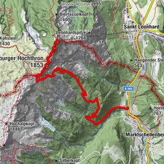
Maria Gern (740 m) - Lauchlehen (840 m) - Kneifelspitze (1189 m)
Geo-koordinaten des ausgangspunkts:.
47.654342, 13.002728 ( in Google Maps öffnen )
Passende Artikel bei Amazon.de:
- Kompasskarte 14 - Berchtesgadener Land, Chiemgauer Alpen
- Rother Wanderführer - Berchtesgadener Land

Einkehrmöglichkeit:
Berggaststätte Kneifelspitze (Paulshütte) (1189 m), Tel. +49 (0)8652/62338. Von Mitte März bis Anfang November täglich von 09:00 bis 18:00 Uhr geöffnet. Im November und Dezember jeweils Samstag und Sonntag und in den Weihnachtsferien von 25. Dezember bis 06. Januar täglich geöffnet.

Berchtesgaden - Wandern & Bergtouren

Touren in der Umgebung:

Folge hoehenrausch.de:
Unsere partner:.

Navigation:
über uns:.
- 0 Shopping Cart € 0,00 -->
Scenic Hike on Picturesque Kneifelspitze – A great view in Berchtesgaden
If you are looking for a hike that is not overly difficult, but not too easy either, Berchtesgadener Land in Bavaria, Germany has a Kneefelspitze route that will scratch that outdoor itch.
Mountain Moments is here to prepare you for this 2.5 hour, 6.4-km adventure, with a trail map, comprehensive but easy-to-understand photography workshops, and expert hiking tips and tricks.
What’s so special about Kneefelspitze? This is what awaits you on the location

A little less known view, but still as impressive or romantic as any, comes from the Maria Gern chapel and the Kneifelspitze elevation.
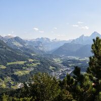
Here you can enjoy a south-facing location with fantastic views over Berchtesgaden towards the national park – with the Watzmann and its impressive rock face in the center.
Especially in late autumn, the view over the sea of fog on the sunny slope inspires all visitors. This special moment is accompanied by a culinary summit rest: the tender spinach dumplings in melted butter taste even better after all the effort.
Directions! This is how your Kneifelspitze trail looks like on a map
The start and endpoint of this tour are at the car park/bus stop Maria Gern (740m). Directly at the church, turn left up the steep road. At the junction, we take the hiking trail on the right to Marxenhöhe and keep right again after about 10 minutes.
From the vantage point (830m) back to the crossroads and right along the circular hiking trail to the Kneifelspitze. Arriving at the road, we follow it on the right-hand side, always gently uphill to the Pauls hut at the summit of the Kneifelsspitze (1189m).
Refreshment stops on this hiking route are Maria Gern and Pauls Hütte .

Before the well-deserved break, we invest another 2 minutes and go to the “Blick nach Salzburg” (signposted) and back to the hut.
On the way back, first follow the road down two hairpin bends and turn right at the first hiking trail sign in the direction of Maria Gern via Lauchenlehen. Briefly downhill on the forest road and turn right again in the direction of Maria Gern.
After a few meters of the beautiful hiking trail from the parking lot, continue downhill along the road to the starting point.
Photo tips that will make your Instagram pop! The Maria Gern chapel and Marxenhöhe viewing point

Three top photo spots await us on this tour – the most famous of which is right at the start: the Maria Gern chapel with the winding road as an imaging element. It can get crowded here at sunrise.
Mountain Moments Photo Workshops provide Photo Tours for everybody, Alpine Experience for beginners and intermediate-level photographers with 3 to 6-hour routes, as well as Summit Experience for more advanced photographers and hikers. We have private workshops and group classes .
The viewing point at the Marxenhöhe, which is only a 25-minute walk away, is significantly less busy. Here we have one of the best panoramas in the Berchtesgadener Land.
Only the view from the summit tops the whole thing: the Berchtesgadener Land spreads out in front of us at the Pauls Hütte, while on the other side of the mountain the Hochstaufen and the view as far as Salzburg greet us.

More information about your hiking adventure – from arrival to the finish line
Arrival: From Berchtesgaden to the district clinic/Maria Gern, then right towards Maria Gern uphill to the signposted parking lot n.
Public transport: By bus or train to Berchtesgaden, regional bus 837 from Berchtesgaden main station in the direction of Hintergern to the Maria Gern stop.
Difficulty: easy-medium
Duration: 2.5 hours, 6.4 km
Ascent/descent: 430hm/430hm
Highest/lowest point: 1189m/730m
Refreshment stop: Maria Gern, Pauls-Hütte ( Kneifelspitze )
Start/finish: car park/stop Maria Gern near Berchtesgaden (coordinates: geogr. 47.653589, 13.002802)
Particular dangers: –
Tips: Please note the private properties near the church.
The most beautiful photo spots and hikes in the German Alps – experience this hiking tour and 29 other exceptional regions now.

Fancy more hikes in the mountains – and beautiful photos? Get out into nature! Experience the best hikes and locations with our new book: German Alps – Photo and Hiking Guide. The 90 best Photo Locations and 30 most panoramic Hikes.
Here we have compiled the most beautiful locations and photo opportunities . 30 hikes with 90 photo spots are selected and described in such a way that you can easily experience these wonderful landscapes in Bavaria for yourself – including GPS tracks and hiking map and all other information.
You can take a closer look at the ebook here – – why not give it as a gift to someone you want to visit and photograph these places with!
Of course, you will find all the information about this hike in the ebook. You als get the GPS track of this trail, so you are on the safe side and won’t get lost and will find all photo locations easily.
Feel invited to comment when you have finished this hike, thanks.

Hi, i am Marius, i love exploring the mountains and nature. Friends say, i know the mountains better than most locals, but actually i get lost all the time while photographing ;). Read more about the Mountain Moments Team .
You might also like

Leave a Reply
Leave a reply cancel reply.
Your email address will not be published. Required fields are marked *
Save my name, email, and website in this browser for the next time I comment.
- Photography Workshops, Classes & Tours
- Private Photo Workshop


Kneifelspitze

Katharina hat die Bewertung „traumhaft schön“ abgegeben.
Von der Wallfahrtskirche Maria Gern führt uns der Kneifelspitzweg zum Weiler Lauch. Dort biegen wir nach links ab und umrunden den Weiler. Nach einem Waldstück bringt uns der Weg steil amsteigend im Zickzack hinauf auf den den 1188 m hohen Gipfel der Kneifelspitze, wo wir in der Berggaststätte "Paulshütte" einkehren können. Nachdem wir uns gestärkt haben und die herrliche Aussicht von Berchtesgadens Hausberg auf den Ort und den Watzmann genossen haben, steigen wir auf dem bekannten Weg wieder hinab nach Maria Gern.
Autorentipp

Einkehrmöglichkeiten
Sicherheitshinweise, weitere infos und links.
Wanderung auf die Kneifelspitze
Abendwanderung zur Kneifelspitze
Wegbeschreibung
In Maria Gern führt der bezeichnete AV-Weg 15 , der Kneifelspitzweg, zwischen der Wallfahrtskirche und dem Gasthaus Maria Gern sehr steil zum Parkplatz unterhalb des Lauchlehens. In der ersten Kehre zweigt der Wanderweg zur Marxenhöhe nach rechts ab. Die Variante über die Marxenhöhe belohnt den etwa 10 minütigen Umweg mit einem fantastischen Blick auf das Berchtesgadener Tal vom Aussichtspunkt.
Vorbei an Bauernhäusern führt der Weg am linken Wiesenrand aufwärts in den Wald. Bei der Einmündung in den breiten Weg auf 935 Metern links halten und auf dem Weg wandern bis an sein Ende. Am Ende des Weges führen steile Serpentinen zur Einmündung des vom Metzenleitenlehen heraufführenden Fahrweges. Diesem Weg folgt man nach links und erreicht so die Berggaststätte Paulshütte beziehungsweise den Gipfel der Kneifelspitze.
Öffentliche Verkehrsmittel
Suche fahrplan zum zielort, koordinaten, buchempfehlungen des autors.
- feste Schuhe
- Wanderstöcke
Ähnliche Touren in der Umgebung
- Gerer Höhenweg und Gerer Klamm
- Maximilians Reitweg
- Märchen- und Trimm-Dich-Pfad Bischofswiesen
- Untersbergrunde Tag 1: Berchtesgaden - Hintergern - Stöhrhaus
- Berchtesgadener Talweg: 4. Etappe Berchtesgaden - Marktschellenberg - Berchtesgaden
Fragen & Antworten
Bewertungen.

Fotos von anderen
Wetter am startpunkt der tour.
- Bilder einblenden Bilder ausblenden
- 4 Wegpunkte

Kneifelspitze von Maria Gern
- Einkehrmöglichkeit
Tourenbeschreibung
Die Kneifelspitze ist praktisch der Hausberg der Berchtesgadener in Bayern und bietet von seinem Gipfel auf 1.189 m ein umwerfendes Panorama unter anderem auf den Hohen Göll und den Watzmann.

Höhenprofil
Bergwelten-tipp.
Die Paulshütte - oder Berggaststätte Kneifelspitze - lädt zu einer gemütlichen Rast am Gipfel ein.
Anfahrt & Parken
Autobahnabfahrt Bad Reichenhall, weiter bis Bad Reichenhall, hier weiter auf der B20 nach Berchtesgaden. In Bischofswiesen links abzweigen nach Anzenbach und hier der Beschilderung nach Maria Gern folgen.
Parkplatz Maria Gern
Öffentliche Verkehrsmittel
Mit der Bahn nach Berchtesgaden, mit dem Bus nach Maria Gern.
Weitere Tourenempfehlungen

Wanderung zum Purtschellerhaus von der Enzianhütte

Wanderung zur Kreealm-Kreehütte von Stockham/Hüttschlag

Wanderung zur Sausteigalm von St. Gilgen

Wanderung zur Gsengalmhütte von der Bergstation der Karkogelbahn / Abtenau
Bergwelten entdecken, unterkünfte.
- Tourensuche
- Tourenplaner
- Reiseführer
- Ausflugsziele
- Essen & Trinken
- Unterkünfte
- Klettergebiete
- Aktuelle Bedingungen
- Lawinenlage
- Veranstaltungen
- Geschichten
- Bücher & Karten
- Einstellungen
Wanderung auf die Kneifelspitze

Berchtesgadener Land: Aussichtsreicher Rundwanderweg
Autorentipp.

Einkehrmöglichkeiten
Sicherheitshinweise.
Müssen Sie keine beachten, es ist ein sehr schöner Wanderweg!
Weitere Infos und Links
Besuchen Sie unsere kostenlose König-guat APP
- Für Android im Google Play Store
- Für Iphone/Apple im APP Store
Wegbeschreibung
Start der Wanderung ist direkt bei der Wallfahrtskirche Maria Gern. Zuerst geht es steil der Asphaltierten Strasse Bergauf. In der ersten Kurve zweigt der Wanderweg nach rechts über die Marxenhöhe ab. Sie folgen dem Wanderweg, wo sie von zahlreichen Wandertafeln begleitet werden. Die letzten 100 Höhenmeter führt Sie der Weg durch den Wald und über Wurzeln. Am Ende dieses Weges zweigen Sie nach links ab und nach ca. 10 Minuten erreichen Sie die Kneifelspitze und die Paulshütte auf 1189 Höhenmeter. Der Abstieg erfolgt bis zur Abzweigung Lauch gleich wie der Aufstieg. Ab dieser Abzweigung folgen Sie dem Wanderweg zurück bis zur Wallfahrtskirche Maria Gern.
Öffentliche Verkehrsmittel
Mit der Deutschen Bahn und den lokalen Busunternehmen .
Koordinaten
Buchtipps für die region, kartentipps für die region.
- Festes Schuhwerk
- Wanderstecken von Vorteil
- genügend zum Trinken
- Regenjacke bzw. Windjacke
Ähnliche Touren in der Umgebung
- Kneifelspitze - Leichte Aussichtstour mit Gipfelrestaurant
- Auf die Kneifelspitze
- Maria Gern - Kneifelspitze - Marxenhöhe
- Kneifelspitze mit Panorama- und Salzburgblick
- Rundwanderung Maria Gern
Fragen & Antworten
Hier kannst du gezielt Fragen an den Autor stellen.
Bewertungen
Gib die erste Bewertung ab und hilf damit anderen.
Fotos von anderen
Wetter am startpunkt der tour.
- Bilder einblenden Bilder ausblenden
- 3 Wegpunkte
- Schneehöhe Mit Pro+ freischalten
Ausflugsziele und Freizeittipps in der Region
- Unterkünfte
- Sportanbieter
Kneifelspitze

Leichte Wanderung auf den kleinen Berchtesgadener Hausberg
Wallfahrtskirche Maria Gern
Von der Wallfahrtskirche Maria Gern führt uns der Kneifelspitzweg zum Weiler Lauch. Dort biegen wir nach links ab und umrunden den Weiler. Nach einem Waldstück bringt uns der Weg steil amsteigend im Zickzack hinauf auf den den 1188 m hohen Gipfel der Kneifelspitze, wo wir in der Berggaststätte "Paulshütte" einkehren können. Nachdem wir uns gestärkt haben und die herrliche Aussicht von Berchtesgadens Hausberg auf den Ort und den Watzmann genossen haben, steigen wir auf dem bekannten Weg wieder hinab nach Maria Gern.
In Maria Gern führt der bezeichnete AV-Weg 15 , der Kneifelspitzweg, zwischen der Wallfahrtskirche und dem Gasthaus Maria Gern sehr steil zum Parkplatz unterhalb des Lauchlehens. In der ersten Kehre zweigt der Wanderweg zur Marxenhöhe nach rechts ab. Die Variante über die Marxenhöhe belohnt den etwa 10 minütigen Umweg mit einem fantastischen Blick auf das Berchtesgadener Tal vom Aussichtspunkt.
Vorbei an Bauernhäusern führt der Weg am linken Wiesenrand aufwärts in den Wald. Bei der Einmündung in den breiten Weg auf 935 Metern links halten und auf dem Weg wandern bis an sein Ende. Am Ende des Weges führen steile Serpentinen zur Einmündung des vom Metzenleitenlehen heraufführenden Fahrweges. Diesem Weg folgt man nach links und erreicht so die Berggaststätte Paulshütte beziehungsweise den Gipfel der Kneifelspitze.
Paulshütte, Kneifelspitze
feste Schuhe Wanderstöcke
Achtung: Stellenweise ist der Weg sehr steil!
Den Abstecher zum Aussichtspunkt Marxenhöhe soltle man sich nicht entgehen lassen: Dort steht eine ganz besodnere Schaukel!
Wanderung auf die Kneifelspitze
Abendwanderung zur Kneifelspitze
B305 bis Berchtesgaden, weiter über die Locksteinstraße nach Maria Gern oder B20 bis Bischofswiesen, von dort über die Aschauerweiherstraße in Richtung Maria Gern
Buslinie 837 - Berchtesgaden Richtung Hintergern, Bushaltestelle "Maria Gern"
Berchtesgaden, Maria Gern
- GPX GPS Exchange Format (XML)
- KML Google Earth, Google Maps

Allgemeine Infos
- Berchtesgadener Land 1672
- Berchtesgaden 666
Beliebte Touren in der Umgebung
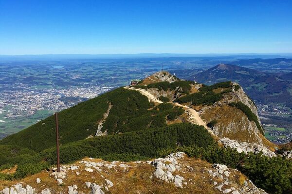
Untersberg ab Marktschellenberg zum Salzburger Hochthron
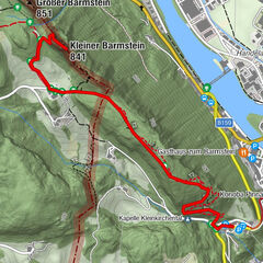
Wanderung zum Kleinen Barmstein über die Ruine Thürndl
Fuschlseewanderung


Moobly - Mitfahrzentrale

Wandern im Winter

Skitourenkurs

Unterwegs am Nockberge-Trail

Hochwanner - Bike & Hike

Klettersteig-Spezial
Bergtour - kneifelspitze.

Kneifelspitze (1189 m)
Bergtour | berchtesgadener alpen | berchtesgaden 490 hm | insg. 03:15 std. | schwierigkeit (1 von 6).
Für diese Tour derzeit leider nicht verfügbar.
Um diese Funktion zu nutzen, loggen Sie sich bitte ein.
Tour mit Freunden teilen
Tourensteckbrief Kneifelspitze
Bilder zur Tour

Die Kneifelspitze vor dem Untersberg mit dem ungefähren Wegverlauf.

Vom Parkplatz sieht man auf den Weg um das Lauchlehen – und weit oben das Ziel.

Gutes Zeichen: Die Fahne weht, die Einkehr ist gesichert.

Panorama, in echt und mit Beschriftung.

Die Berggaststätte Kneifelspitze

Freier Blick auf die Berchtesgadener Bergwelt

Das Gipfelkreuz steht direkt auf der Sonnenterrasse.

Am Nebengipfel zeigen sich Untersberg und die Hochfläche von Ettenberg.

Bequem: Der Rundweg um die Kneifelspitze

Gut beschildert: Die Wege an der Kneifelspitze

Immer wieder schön: Der Panoramaweg über die Marxenhöhe

Postkartenmotiv: Die Wallfahrtskirche Maria Gern
Karten und Routenskizze
Auf dem Kartenausschnitt können Sie die Lage der Tour und die Anfahrt nachvollziehen. Soweit ein GPS-Track hinterlegt ist, dient die Karte auch als Routenskizze.

Download GPS Daten
Wettervorhersage.

Top - Bergtouren aus der Region Berchtesgadener Alpen
Hier finden Sie die schönsten Touren aus dieser Gegend. Die Region Berchtesgadener Alpen ist bekannt für ihre Vielfalt, für ihren landschaftlichen Reiz und hohen Erholungswert. In unserem Tourenarchiv finden Sie dazu Gebietsinformationen und weitere lohende Routenvorschläge mit Bildern und GPS-Daten.
Kommentar zur Tour
Es gibt keine kommentare zu dieser tour..
Kneifelspitze Hike

Just across the border from Salzburg where I live is the exquisite Berchtesgaden National Park in Bavaria, Germany. I explored some of Berchtesgaden two summers ago on a biking and hiking day trip to Königssee, Obersee und Röthbachfall , and again earlier this spring with a hike around Hintersee .
The Berchtesgaden National Park is perhaps most famously home to the Eagle's Nest, a Nazi building on the summit of the Kehlstein, used by members of the Nazi Party for government and social meetings. However, it is the exquisite natural landscapes that draw many visitors to this incredible region, home to alpine lakes, hikes, mountain ranges and wonderful views.
This time, in search of a gorgeous afternoon hike to properly kick off the arrival of the hot summer weather to the area, Karolina and I drove about half an hour southwest of Salzburg to Maria Gern and hiked all the way up to the Kneifelspitze which offers a beautiful panoramic view of the Untersberg and back towards Salzburg in one direction, and overlooking the town of Berchtesgaden and Der Watzmann mountain in the other.
The hike was the perfect length, although it does feature a number of switchbacks at the top! We stopped for dinner at Maria Gern right next to the iconic pink Wallfahrstkirche on the way back down and I always say that food tastes better (a) after a hike and (b) when eaten outside. We loved this hike and said "wow" at least 100 times at all the different views.
KNEIFELSPITZE HIKE DETAILS
When: year-round, but recommended on a clear, sunny day
Where: Berchtesgaden National Park, Germany
Difficulty: intermediate, with quite a few switchbacks
Length: the return loop trail from Maria Gern to Kneifelspitze was 9km and just over 500m elevation gain according to my Strava which took us just over two hours of moving time, plus of course lots of time to take photos and enjoy the different viewpoints!
Directions: we parked on the road (P3) near Maria Gern and then followed the yellow signs up to Kneifelspitze, with the final destination the Paulshütte which boasts epic views over Berchtesgaden. Check out my Strava activity for our exact route .
Bathrooms: yes, at the Maria Gern and at the Paulshütte
Public Transit: yes, bus 837 runs from Salzburg Hauptbahnhof to Hintergern and stops at Maria Gern

Spotted lambs on our drive home

The townof Berchtesgaden at golden hour
PIN THIS POST TO REFER BACK TO LATER!

Share this:
- Click to share on Twitter (Opens in new window)
- Click to share on Facebook (Opens in new window)

Hi! I’m Jana, a British-Dutch-Canadian with a dream of seeing every country in the world. I am a storyteller, photographer and adventurer passionate about documenting and sharing my travels.
Find me on: Twitter | Instagram | Facebook
Other Posts You May Like
Visiting neuschwanstein castle, königssee, obersee & röthbachfall hike, best lakes near salzburg, this is germany’s cutest town, leave a reply cancel reply.
Your email address will not be published. Required fields are marked *
Notify me of follow-up comments by email.
Notify me of new posts by email.
This site uses Akismet to reduce spam. Learn how your comment data is processed .
- Travel tips
- Photography
- Mediakit & Collaboration
- In the media
- Press releases
Berchtesgaden: 15 easy (family) hikes amid beautiful scenery
The Berchtesgadener Land and especially the Alpine region is among the most impressive landscapes in Germany. There are many more superb hikes in the Berchtesgaden Alps – and not all of them are reserved for professionals. In the Berchtesgadener Land, there are a lot of easy tours suitable for beginners and families with children. We want to show you 15 of these dream tours amid breathtaking scenery.

Hi! Wir sind Biggi & Flo
Wir nehmen dich als Reisejournalisten mit zu den schönsten Orten der Welt! Werbehinweis: Alle mit einem * markierten Links sind Werbelinks.
Hiking in Berchtesgadener Land

Next to the Zugspitze near Garmisch-Partenkirchen, the Watzmann is the most famous mountain in Germany – and also the most distinctive. With its double peak, the Watzmann – located in the Berchtesgaden National Park – can be recognized from afar.
The Watzmann crossing is considered a dream tour among mountaineers, but it requires alpine experience and a lot of stamina. But don’t worry, for beautiful views and great tours, it does not always have to be an extreme mountain hike.
In the Berchtesgaden Alps there are many other first-class hikes – and not all of them are reserved for mountain professionals. We show you the most beautiful mountain tours that you can also do as a beginner or as a family with children.
Map: Easy hikes in Berchtesgadener Land
Here you can find our top hikes in Berchtesgaden on the convenient overview map:
[mapsmarker layer=”31″]
1. Toter Mann

Climbing the 1391-meter high mountain by the name of Toter Mann (translated: Dead Man) – also called “sun terrace of Ramsau” – is a classic hike in the Berchtesgadener Land and doable almost all year round. This easy hike is also well-suited for beginners.
The starting point is the parking site of the mountain inn Zipfhäusl (Schwarzecker Weg 8, 83486 Ramsau bei Berchtesgaden). At first, you follow the street and soon afterwards turn onto a wide road way. When you reach the mountain hut Bezoldhütte, which was built in 1883 at the top of the Toter Mann, you will have covered a distance of four kilometers as well as about 500 meters in height.
The route doesn’t cause any problems and is very popular with families and children. If you’re not in a hurry and take your time, you’ll reach the peak in around two hours. Countless benches and green meadows invite you to enjoy the view of the Watzmann – and let me tell you, it is stunning.
If you’re not keen on the climb, you can take the Hirscheck chairlift to the top. If you’re more ambitious, descend to the saline pipeline path (Soleleitungsweg). The trail requires a bit of surefootedness but is still manageable.
Once you’ve arrived at the saline pipeline path, you’ll be welcomed by the mountain inn Söldenköpfl, which is open all year. The view from here is absolutely breathtaking. A gorgeous forest track – the former saline pipeline path – will take you to the mountain inn Gerstreit. And – you might have guessed it – the view from here is also amazing. From the inn, you can return to the parking site.
Total trail length: 11.9 kilometers (considerably shorter with the Hirscheck chairlift) – Elevation gain: 570 meters
2. Soleleitungsweg

From the mountain inn Söldenköpfl, hikers can enjoy an incredible panoramic view over the mountains. The inn is also one of the stops of the circular hike to the Toter Mann, but if you’re not ready for that tour, start from the parking site at the mountain inn Zipfhäusl (Schwarzecker Weg 8, 83486 Ramsau bei Berchtesgaden).
From there, you can take the Soleleitungsweg to the mountain inn Söldenköpfl , which is a route of about five and a half kilometers. This former saline pipeline path is breathtaking and the view is hard to beat. In total, the round trip adds up to almost eleven kilometers, but the elevation gain is minimal. If that is still too far for you, you can walk a mere three kilometers to the mountain inn Gerstreit .
Total trail length: 10.6 kilometers – Elevation gain: – meters
3. Hintersee circular hike

The Hintersee is one of the most beautiful mountain lakes in Bavaria. The short circular hike around the lake is amazingly beautiful, perfectly suitable for families and normally also doable in the winter. However, it can get quite slippery, so you might want to use crampons .
The circular hike around the Hintersee is just under three kilometers long, so you’ll need about an hour. By the way, the lake also provides one of the most well-known photo subjects in the Berchtesgadener Land. In the summer, you can rent a boat and explore the Hintersee on the water.
Total trail length: 2.9 kilometers – Elevation gain: – 0 meters
4. Dötzenkopf

The Dötzenkopf is exactly 1001 meters high and thus the smallest one-thousander in Germany. The hike is ideal for beginners and families with children. As one of the backyard mountains of Bad Reichenhall, the Dötzenkopf is a popular destination among locals, too.
No matter if it’s after work or during lunch break, they go there all the time. From the parking site, a nice trail leads you upwards pretty quickly. It’s beautiful and not that difficult, but it still requires a certain degree of surefootedness as there’s the occasional root or stone tread to overcome.
Even though it’s just 1001 meters high, the peak presents a stunning view over Bad Reichenhall and the surrounding mountains. In addition, some benches at the peak call for a delicious snack.
Total trail length: 3.5 kilometers – Elevation gain: 350 meters
5. Almbach Gorge

The Almbach Gorge is among the most beautiful gorges in the German Alps. Unlike the Partnach Gorge in Garmisch-Partenkirchen, the Almbach Gorge is not that overcrowded and provides an unforgettable experience of nature.
From the parking site, a broad forest trail runs along the Almbach stream and gets narrower and narrower. The hiking trail through the Almbach Gorge is absolutely GORGEous (pun intended). The path is mostly secured but not at all places. Especially if it’s wet, caution is advised.
The final destination of the hike is the Sulzer Wasserfall, which is the eleventh highest waterfall in Germany with 114 meters. The Almbach Gorge is usually open from May to October and closed during the colder months.
Total trail length: 3.5 kilometers – Elevation gain: 200 meters
6. Grünstein

The 1304-meter high Grünstein is one of the mountains with the best view of the Watzmann. The easiest trail onto the Grünstein starts at the parking site Hammerstiel in Schönau. From there, a broad forest track, which gets narrower along the way, leads you up to the peak in about one and a half hours. This version is also suitable for beginners and families, while the alternative route starting from Schönau am Königssee is a bit more difficult.
At times, this trail can get pretty steep and requires some surefootedness in the upper part, especially when descending over the loose boulders. If you’re looking for a challenge, try taking the Grünstein via ferrata (level of difficulty: B/C, options: D/E). Please be aware that you can only take the via ferrata for going up to the peak – climbing down that path is strictly forbidden.
Total trail length: 8.6 kilometers – Elevation gain: 690 meters
7. Malerwinkel circular trail

The Malerwinkel circular trail runs along the Königssee and is also suitable for families with children. The view of the lake from different viewpoints along the way is truly beautiful. You can reach the Malerwinkel viewpoint after a very short hike; sit down on one of the two benches there to let the gorgeous panoramic view sink in. The circular trail now leads you in the direction of Rabenwand. This short detour is not a must, but definitely worth it.
Total trail length: 4.7 kilometers – Elevation gain: 190 meters

The hike onto the 1782-meter high Zwiesel – the highest peak within the Staufen massif – is a relatively easy mountain tour for the whole family. The view from the peak is really breathtaking. For the hike, you will need a basic amount of stamina and surefootedness, especially in the upper part of the trail.
All in all, the climb is pretty manageable, though. Halfway along the route, you can stop by at the Zwieselalm for food and drinks (private business, open from mid-May to mid-October, in good weather sometimes also drinks in autumn, tel.: +49-8651-3107, no website).
Total trail length: 8.1 kilometers – Elevation gain: 870 meters
9. Kneifelspitze

The hike onto the Kneifelspitze is among the outright hiking highlights in Berchtesgaden. The tour is relatively short and also suitable for beginners. Even though it’s just 1189 meters high, the peak provides a stunning view of the Watzmann .
The starting point of the hike is the pilgrimage Church of Maria Gern, one of the most famous photo subjects in Bavaria . Follow the hiking trail AV-Weg 15, the so-called Kneifelspitzweg. Shortly after the start, you can make a slight detour to the Marxenhöhe , a fantastic viewpoint with some benches to enjoy the amazing view.
At the peak of the Kneifelspitze you cannot only enjoy a great view, but also stop off at the mountain inn Paulshütte .
Total trail length: 6.4 kilometers – Elevation gain: 520 meters
10. Litzlalm

The Litzlalm (open daily from mid-May to mid-October) is located amid beautiful scenery and was a filming location for many regional films and TV series like “Der Bergdoktor” (translated: “The Mountain Doctor”).
Yes, the Litzlalm is the incarnation of everything you associate with a holiday in the mountains. The hike is pretty long and starts at the beautiful Hintersee. In the beginning, the trail runs alongside a rushing stream called Klausbach. After about an hour, you take the ascending path to the Litzlalm.

You’ll pass the Bindalm and the Gasthaus am Hirschbichl before arriving at your destination after three to three and a half hours. However, in this gorgeous scenery, time flies! If you don’t feel like hiking quite that far, just take the bus: the Almerlebnisbus will take you through the Klausbachtal valley all the way to Hirschbichl . From that stop, it’s only a short hike to the Litzlalm.
Extra tip: from the Litzlalm, it’s not far to the Litzlkogel (1625 m), from where you have another amazing view. By the way, the tour to the Litzlalm is also very popular among mountain bikers. This tip comes from Toni Wegschneider from Wildtier-Führungen , who offer hikes with experts on the wildlife of the Alps.

Total trail length: 16.6 kilometers (considerably shorter with the Almerlebnisbus) – Elevation gain: 530 meters
11. Stubenalm

The Stubenalm just below the mountain hut Watzmannhaus is also a popular destination among hikers. You can either start the tour at the Wimbach Bridge in Ramsau or the parking site Hammerstiel in Schönau.
From both locations, you can reach the Stubenalm in about one and a half hours. From there, you have an amazing view of the Reiter Alm and the Hochschwarzeck. Two alpine cabins offer food and drinks to hikers amid wonderful mountain scenery.
Total trail length: 6.0 kilometers – Elevation gain: 520 meters
12. Halsalm

The circular hike via the Halsalm starts from the lake Hintersee and leads you into the valley Klausbachtal at the beginning. Shortly after, you’ll have to turn right onto a broad, curvy path in the direction of Halsgrube. The Halsalm is open in summer and provides a stunning view of the Hintersee. You will descend through the Antonigraben, which does require some surefootedness.

Total trail length: 6.0 kilometers – Elevation gain: 440 meters
13. Ragert Alm

The hike to the Ragert Alm also starts from the Hintersee. The tour follows a simple trail through the wild and romantic valley Klausbachtal that’s well-known for its golden eagles. The trail to the Ragert Alm branches off at a wooden bridge, from where you should reach the alp in just 15 minutes.
Just follow the signposts. The trails are very nice and even suitable for families with small children. The hike is doable in about an hour. If that’s too far, you can also take the Almerlebnisbus through the Klausbachtal valley. Get out at the stop Ragert Alm and you will only have about 15 minutes left to walk.
Total trail length: 5.8 kilometers – Elevation gain: 90 meters

The Jenner is one of the most beautiful peaks in the Berchtesgadener Land. The view of the Königssee and the Watzmann is breathtaking. The cable car Jennerbahn will take you up to almost 1800 meters.
It takes around 20 minutes from the summit station to the actual peak. If you’re in for a real hike though, you’ll climb the mountain on foot. The starting point of the tour is the parking site Hinterbrand. You’ll follow the forest track to the middle station of the Jennerbahn and continue on the Königsweg, a forest road on which you’ll pass many alpine pastures and meadows. You can also combine the Jenner hike with the Schneibstein (#15 on our list).
Total trail length: 12.6 kilometers – Elevation gain: 750 meters
15. Schneibstein

Have you always wanted to climb a two-thousander but never dared to actually do it? The Schneibstein is the chance you’ve been waiting for. After all, it’s considered the easiest two-thousander in the Berchtesgaden Alps.
Following the Königsweg, the climb is pretty unproblematic from the middle station of the Jennerbahn (the parking site Hinterbrand requires a small fee) until you reach the mountain hut Carl-von-Stahl-Haus at 1736 meters. If you’ve decided to hike instead of taking the cable car, you should spend the night at the Stahl-Haus and tackle the Schneibstein peak the next day.
With more than 16 kilometers, the tour would otherwise be too long for beginners. From the Stahl-Haus, a nice mountain trail leads all the way up to the peak. Surefootedness is vital but the trail never really gets too difficult. When the Jennerbahn is operating (at the earliest in summer 2018), the hike is also well-manageable as a longer day-tour.
Total trail length: 16.2 kilometers – Elevation gain: 1160 meters

Florian Westermann
Florian is a travel journalist, photographer and co-founder of the travel blog Phototravellers . "Photography and the mountains are my passion. I've been to North America countless times, but I'm also fascinated by the Nordic countries, Italy and of course our home country Germany." By the way, here you can find my online photography course .
No comments
Your opinion is important to us cancel reply.
Hast du Fragen oder Anregungen? Dann hinterlasse hier einen Kommentar – wir antworten so schnell wie möglich
You might also be interested in

Cool things to do in Munich: 20 beautiful places you must see [with map]

Things to do in Cologne: 10 beautiful places you must see [with map]

The 15 most beautiful Christmas Markets in Germany

Munich: 10 tips for your day in the Englischer Garten

Zugspitze: Hike over the Gatterl – the route for beginners
- Route planner

Horst experienced this adventure with komoot!
Have your own adventure with the #1 outdoor app today., kneifelspitze #3 🏔 v. gasthof dürrlehen, tour overview, html.reactmodal__html--open{overflow:hidden;}html.reactmodal__html--open:not(.fullsize){scrollbar-gutter:stable;}html.reactmodal__html--open.reactmodal__html--panel #pagemountnode:before{content:'';position:fixed;width:100%;height:100%;} gasthof dürrlehen.
Hiking Highlight
Sign up for a free komoot account to see more photos and Highlights from this Tour.
Sign up to see route details
Know exactly what to expect with inch-by-inch surface, waytype, and elevation info.

October 17, 2021
- Create a Copy of This Tour
- Report Tour

Compared to the rise of v. on the other side (Maria Gern) this is the nicer option.
Nice view of the entire Untersberg massif.
Both inns (Kneifelspitze, Dürrlehen) are highly recommended!

Good tip👍I only knew the rise of Maria Gern so far.
Sign up for a free komoot account to join the conversation.
You Might Also Like

COMMENTS
Kneifelspitze (leicht, 450hm, 3h) Die Kneifelspitze (1189m) in den Berchtesgadener Alpen mit dem direkt darauf gelegenen Berggaststätte Kneifelspitze - auch Paulshütte genannt - ist zu jeder Jahreszeit einen Besuch wert. Denn die Aussicht auf die Berchtesgadener Alpen, allen voran Watzmann, Hoher Göll und Hochkalter, sucht für die ...
Leichte Wanderung mit Traumpanorama. Die Wanderung auf die Kneifelspitze ist ein Muss für jeden Berchtesgaden-Urlauber. Durch die freistehende Lage hat man vom Gipfel der Kneifelspitze einen einzigartigen Rundumblick auf den Watzmann und die weiteren Berge rund um das Berchtesgadener Tal. Der Hohe Göll hinter dem Gipfelkreuz der Kneifelspitze.
Maria Gern Andachtsstätte. Kneifelspitze (1.189 m) Gipfel. 2,5 km. Paulshütte Restaurant. 2,5 km. Beschreibung. Die Kneifelspitze ist der Hausberg der Berchtesgadener. Die Tour beginnt bei der Wallfahrtskirche Maria Gern, deren Inneres ebenso wie ihre wunderbare Lage unsere Beachtung verdient. Der Aufstieg ist relativ kurz, aber konstant steil.
Bei einer Wanderung von Maria Gern auf die Kneifelspitze steht nicht die alpine Herausforderung, sondern der Genuss im Vordergrund. Die leichte Tour führt mit überschaubarem Höhenunterschied auf einen sanften Aussichtsberg, der einen fantastischen Ausblick über Berchtesgaden zum Hohen Göll, zum Steinernen Meer, zum Watzmann und zum Hochkalter erlaubt.
Directions! This is how your Kneifelspitze trail looks like on a map. The start and endpoint of this tour are at the car park/bus stop Maria Gern (740m). Directly at the church, turn left up the steep road. At the junction, we take the hiking trail on the right to Marxenhöhe and keep right again after about 10 minutes.
Maria Gern - Kneifelspitze Summit. Discover this 2.7-mile out-and-back trail near Berchtesgaden, Bavaria. Generally considered a moderately challenging route, it takes an average of 1 h 56 min to complete. This is a very popular area for hiking, so you'll likely encounter other people while exploring. The trail is open year-round and is ...
Kneifelspitze. 13 Bewertungen · Wanderung · Berchtesgaden. Verantwortlich für diesen Inhalt. Tourenportal Berchtesgadener Land. Blick von der Kneifelspitze über Berchtesgaden zum Watzmann. Foto: Bergerlebnis Berchtesgaden, Tourenportal Berchtesgadener Land. Katharina Prix. am 14.01.2024.
05:43. 16.2 km. 2.8 km/h. 690 m. 690 m. Plan Your Own Tour. Discover the best hikes and paths to Kneifelspitze in Schellenberger Forst, Berchtesgadener Land. Explore it on the map and plan your own route to Kneifelspitze.
Varied circular route in Berchtesgadener Land, Bavaria. The start is near Maria Gern, there are parking spaces here. It goes north on the Gerner Höhenweg and up to the Kneifelspitze, Berchtesgaden's local mountain. Once here, the breathtaking panorama and a stop at the Paulshütte can be enjoyed. The Almbachklamm is not far away with waterfalls and hiking trails. At a short point on the way ...
Kneifelspitze - View to Salzburg loop from Unterau is an intermediate Hiking Tour. See this Tour and others like it, or plan your own with komoot! Detailed maps and GPS navigation for the hike: "Kneifelspitze - View to Salzburg loop from Unterau" 02:21 h 5.35 km. komoot.
17.000 Touren, 1.600 Hütten und täglich Neues aus den Bergen. Magazin. Touren. Hütten. Unterkünfte. Bergdate. Podcast. ... Die Kneifelspitze ist praktisch der Hausberg der Berchtesgadener in Bayern und bietet von seinem Gipfel auf 1.189 m ein umwerfendes Panorama unter anderem auf den Hohen Göll und den Watzmann.
Top empfohlene Tour Wanderung auf die Kneifelspitze. Wanderung · Berchtesgadener Land Verantwortlich für diesen Inhalt ... Am Ende dieses Weges zweigen Sie nach links ab und nach ca. 10 Minuten erreichen Sie die Kneifelspitze und die Paulshütte auf 1189 Höhenmeter. Der Abstieg erfolgt bis zur Abzweigung Lauch gleich wie der Aufstieg.
Zusatzinfos. Wanderung auf die Kneifelspitze. Abendwanderung zur Kneifelspitze. Anreise. B305 bis Berchtesgaden, weiter über die Locksteinstraße nach Maria Gern oder B20 bis Bischofswiesen, von dort über die Aschauerweiherstraße in Richtung Maria Gern. Öffentliche Verkehrsmittel.
Kleiner Berg, große Aussicht, so könnte man etwa die Kneifelspitze beschreiben. Dank der Lage inmitten des Berchtesgadener Talkessels ermöglicht der freistehende Berg mit Gasthaus direkt am höchsten Punkt eine tolle Rundsicht auf die Berchtesgadener Gipfelprominenz. Entsprechend beliebt ist die Wanderung, die in Maria Gern mit einem ...
Kneifelspitze - BDG is an intermediate Hiking Tour: 4.95 km and takes 02:05 h. View this route or plan your own! Daniela SJ planned an outdoor adventure with komoot! Distance: 4.95 km | Duration: 02:05 h. komoot. Discover. Route planner. Features.
Varied loop in Berchtesgadener Land, Bavaria. The start is near Maria Gern, there are parking spaces here. It goes north on the Gerner Höhenweg and up to the Kneifelspitze, Berchtesgaden's local mountain. Once here, the breathtaking panorama and a stop at the Paulshütte can be enjoyed. The Almbachklamm is not far away with waterfalls and hiking trails. At a short point on the way ...
28. August 2020. 24. Januar 2020. Meld dich kostenlos bei komoot an, um 33 weitere Insider-Tipps und -Tricks zu sehen. Entdeck die besten Wanderungen und Rundwege zum Wandern in der Nähe von Kneifelspitze in Berchtesgaden, Berchtesgadener Land. Plan deine eigene Tour zum Wandern.
Kneifelspitze Hike Just across the border from Salzburg where I live is the exquisite Berchtesgaden National Park in Bavaria, Germany. I explored some of Berchtesgaden two summers ago on a biking and hiking day trip to Königssee, Obersee und Röthbachfall , and again earlier this spring with a hike around Hintersee .
Popular, panoramic loop in Berchtesgadener Land, Bavaria. This hike starts at the car park and the "Staatlicher Gutshof" bus stop in Berchtesgaden. Via Unterau and along the Berchtesgadener Ache, the route leads through the Almbachklamm gorge to the Kneifelspitze. From the peak there is a magnificent view of the Watzmann, the surrounding mountains and a little later even Salzburg.
Kneifelspitze - Aussichtspunkt Kneifelspitze Runde von Gerner Straße is an intermediate Hiking Tour: 5.82 km and takes 02:14 h. View this route or plan your own! Mike planned an outdoor adventure with komoot!
Here you will find the most beautiful tours in the Berchtesgaden Alps in Bavaria. ... The hike onto the Kneifelspitze is among the outright hiking highlights in Berchtesgaden. The tour is relatively short and also suitable for beginners. Even though it's just 1189 meters high, the peak provides a stunning view of the Watzmann . ...
Runde über die Kneifelspitze is an intermediate Hiking Tour: 6.10 km and takes 02:42 h. View this route or plan your own! Gerrit S. planned an outdoor adventure with komoot!
Komoot user Horst recorded a hike: Kneifelspitze #3 🏔 v. Gasthof Dürrlehen. See this route and plan your own adventure with komoot!